Subject: Colonial Mid-Atlantic United States, Revolutionary War
Period: 1776 (dated)
Publication: Scots Magazine
Color: Black & White
Size:
8.5 x 6.8 inches
21.6 x 17.3 cm
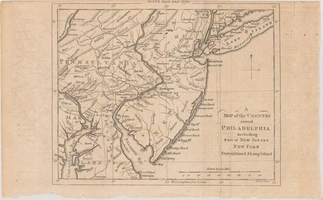
This Revolutionary War period map encompasses the area of Eastern Pennsylvania through Long Island and south to include Chesapeake Bay. The map was issued to illustrate the British Army's objective of defeating Gen. Washington at Long Island and then marching to Philadelphia and putting a quick end to the conflict. It is centered on Philadelphia, includes most of New Jersey, Delaware, Long Island, southwest Pennsylvania, northern Chesapeake Bay, and the greater New York City area. The southern New Jersey coast is labeled Sandy Barren Deserts. The map is filled with interesting features including Indian villages, towns and cities, ferries, and roads (including the distances between towns). Adorned with a simple compass rose. This copper plate was engraved by D. Lizars. This is the uncommon issue created for the Scots Magazine, published from Edinburgh as opposed to the more common issue published the same month in the London-based Gentleman's Magazine. The map carries the imprint "Scots Mag: Sept. 1776" in the upper neatline.
References: Jolly #SCOT-45; Phillips (M) p.699; cf. Sellers and Van Ee #1041.
Condition: B+
Issued folding on watermarked paper with light offsetting and one small worm hole.