Filtered by Category:Canada(Show All Categories)
Showing results for:Auction 168
Catalog Archive
28 lots
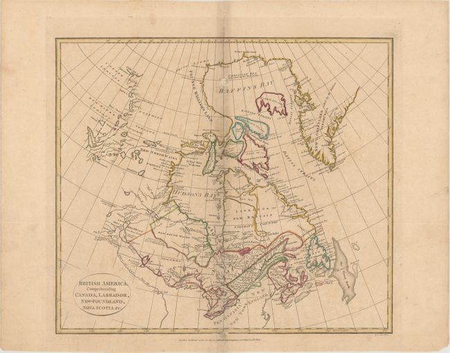
Auction 168, Lot 113
Subject: Canada
Cruttwell, Clement
British America, Comprehending Canada, Labrador, New-foundland, Nova Scotia &c:, 1808
Size: 15.1 x 13.3 inches (38.4 x 33.8 cm)
Estimate: $150 - $180
Sold for: $110
Closed on 6/6/2018
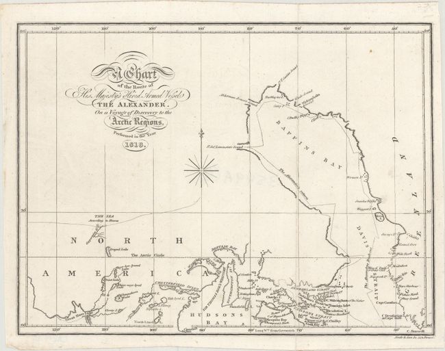
Auction 168, Lot 114
Subject: Northern Canada, Baffin Bay
Parry, William Edward (Adm. Sir)
A Chart of the Route of His Majesty's Hired Armed Vessel the Alexander. On a Voyage of Discovery to the Arctic Regions, 1818
Size: 9.9 x 7.4 inches (25.1 x 18.8 cm)
Estimate: $180 - $210
Sold for: $95
Closed on 6/6/2018
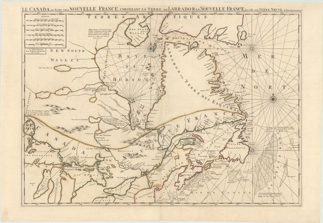
Auction 168, Lot 115
Subject: Eastern Canada
Mortier, Pierre
Le Canada ou Partie de la Nouvelle France, Contenant la Terre de Labrador la Nouvelle France, les Isles de Terre Neuve. De Nostre Dame &c:, 1696
Size: 30.7 x 21.4 inches (78 x 54.4 cm)
Estimate: $1,000 - $1,400
Sold for: $850
Closed on 6/6/2018
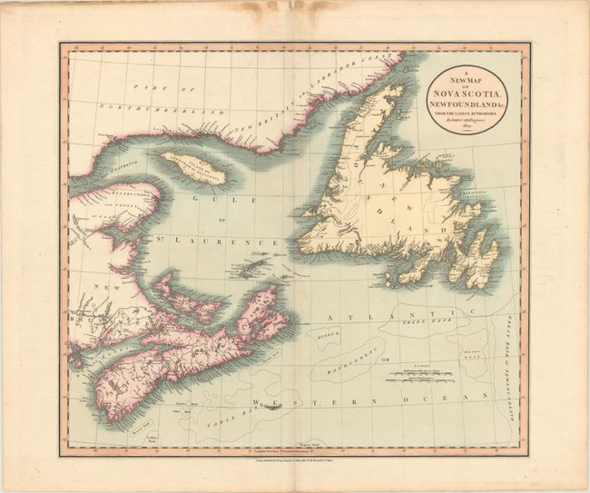
Auction 168, Lot 116
Subject: Eastern Canada
Cary, John
A New Map of Nova Scotia, Newfoundland &c. from the Latest Authorities, 1807
Size: 20.3 x 18 inches (51.6 x 45.7 cm)
Estimate: $140 - $170
Sold for: $100
Closed on 6/6/2018
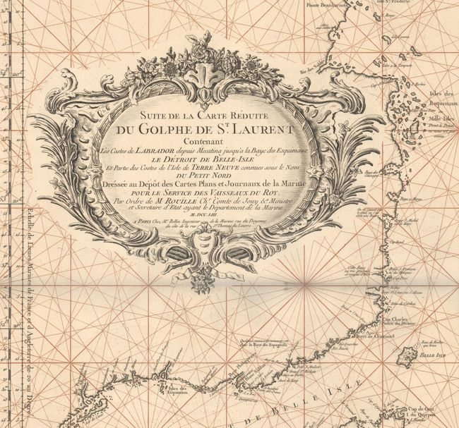
Auction 168, Lot 117
Subject: Labrador & Newfoundland, Canada
Bellin, Jacques Nicolas
Suite de la Carte Reduite du Golphe de St. Laurent Contenant les Costes de Labrador Depuis Mecatina Jusqu'a la Baye des Esquimaux..., 1753
Size: 22.4 x 35.8 inches (56.9 x 90.9 cm)
Estimate: $475 - $600
Sold for: $350
Closed on 6/6/2018
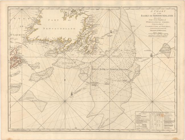
Auction 168, Lot 118
Subject: Newfoundland, Canada
Jefferys/Sayer & Bennett
A Chart of the Banks of Newfoundland, Drawn from a Great Number of Hydrographical Surveys, Chiefly from Those of Chabert, Cook and Fleurieu, Connected and Ascertained by Astronomical Observations, 1775
Size: 26.4 x 19.6 inches (67.1 x 49.8 cm)
Estimate: $275 - $375
Sold for: $200
Closed on 6/6/2018
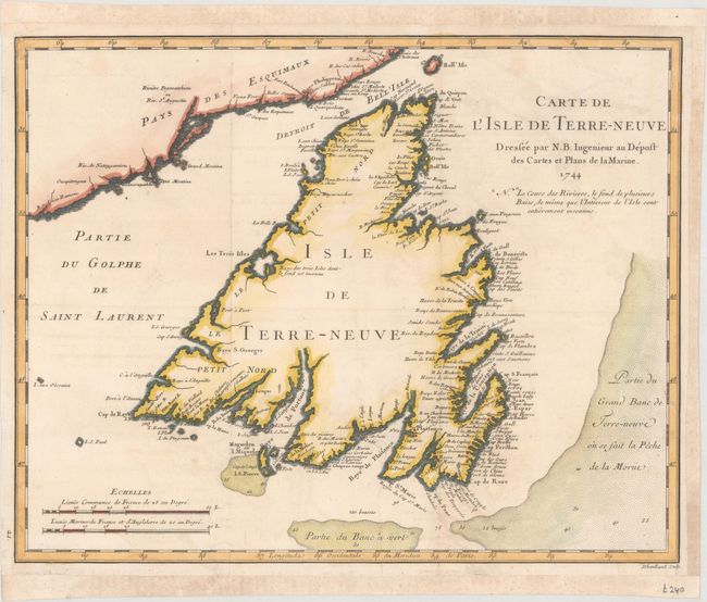
Auction 168, Lot 119
Subject: Newfoundland, Canada
Bellin, Jacques Nicolas
[Lot of 2] Carte de l'Isle de Terre-Neuve [and] Carte des Bayes, Rades et Port de Plaisance dans l'Isle de Terre Neuve..., 1744
Size: See Description
Estimate: $200 - $230
Sold for: $150
Closed on 6/6/2018
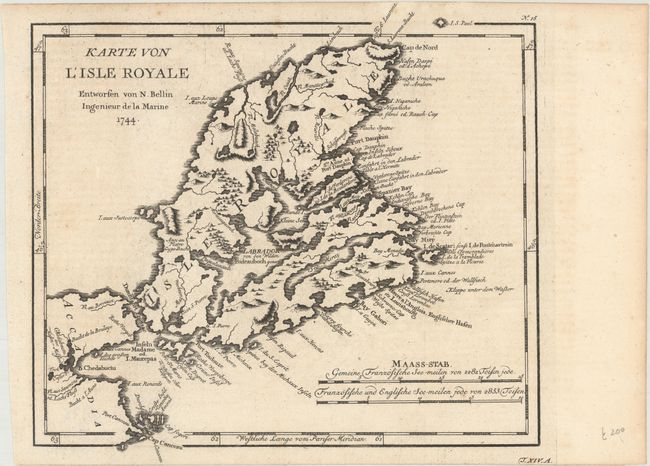
Auction 168, Lot 120
Subject: Cape Breton Island, Canada
Bellin, Jacques Nicolas
[Lot of 2] Karte von l'Isle Royale [and] Grundriss des Hafens Dauphin und Seiner Rheede Nebst der Einfahrt in den Labrador, 1744
Size: 10.6 x 9.6 inches (26.9 x 24.4 cm)
Estimate: $180 - $220
Sold for: $130
Closed on 6/6/2018
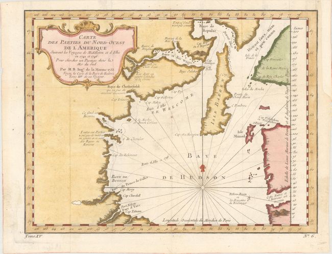
Auction 168, Lot 121
Subject: Hudson Bay, Canada
Bellin, Jacques Nicolas
Carte des Parties du Nord-Ouest de l'Amerique Suivant les Voyages de Middleton et d Ellis en 1742 et 1746..., 1753
Size: 10.9 x 8.3 inches (27.7 x 21.1 cm)
Estimate: $100 - $130
Sold for: $75
Closed on 6/6/2018
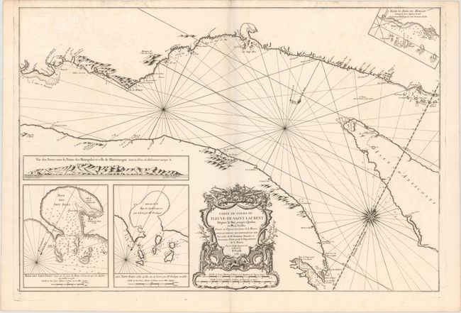
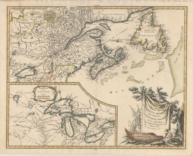
Auction 168, Lot 122
Subject: St. Lawrence River, Canada
Bellin, Jacques Nicolas
Carte du Cours du Fleuve de Saint Laurent Depuis la Mer Jusqu'a Quebec, en Deux Feuilles ... IIe. Feuille, 1761
Size: 33.2 x 22.4 inches (84.3 x 56.9 cm)
Estimate: $400 - $500
Unsold
Closed on 6/6/2018
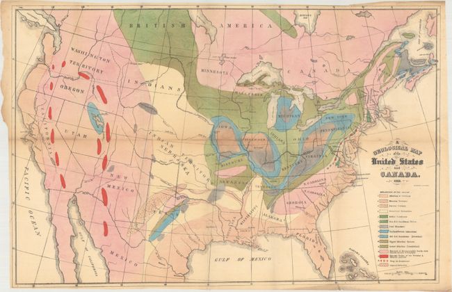
Auction 168, Lot 123
Subject: United States & Canada, World
Hitchcock, Edward
[Maps with Report] A Geological Map of the United States and Canada [and] Outline of the Geology of the Globe, 1856
Size: 5.5 x 8.7 inches (14 x 22.1 cm)
Estimate: $1,000 - $1,300
Includes Hitchcock's First Geological Map of the United States
Sold for: $750
Closed on 6/6/2018
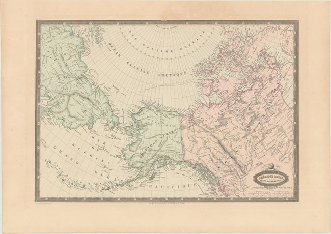
Auction 168, Lot 124
Subject: Northern United States & Canada, Alaska, Asia
Garnier, Francis Marie Joseph
Amerique Russe, et Partie des Regions Polaires Boreales, 1860
Size: 18.8 x 13 inches (47.8 x 33 cm)
Estimate: $140 - $170
Sold for: $90
Closed on 6/6/2018
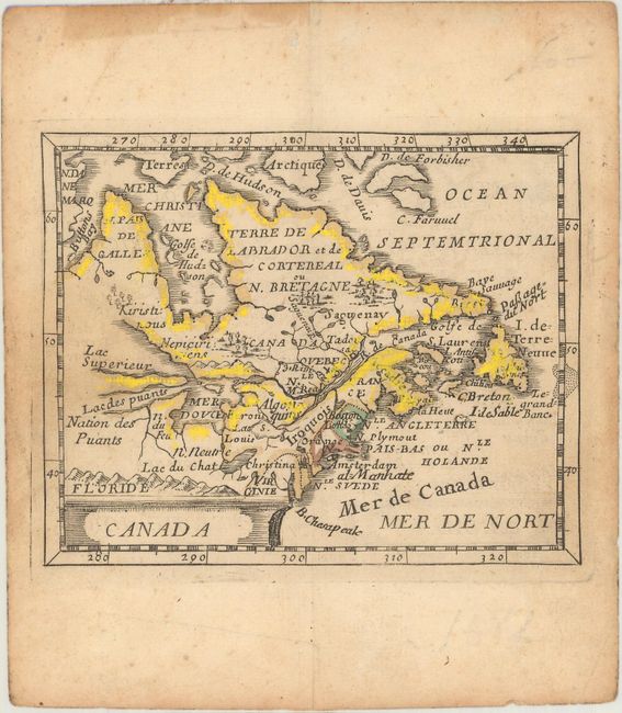
Auction 168, Lot 125
Subject: Colonial Northeastern United States & Canada
Duval, Pierre
Canada, 1682
Size: 4.8 x 3.8 inches (12.2 x 9.7 cm)
Estimate: $375 - $450
Sold for: $190
Closed on 6/6/2018
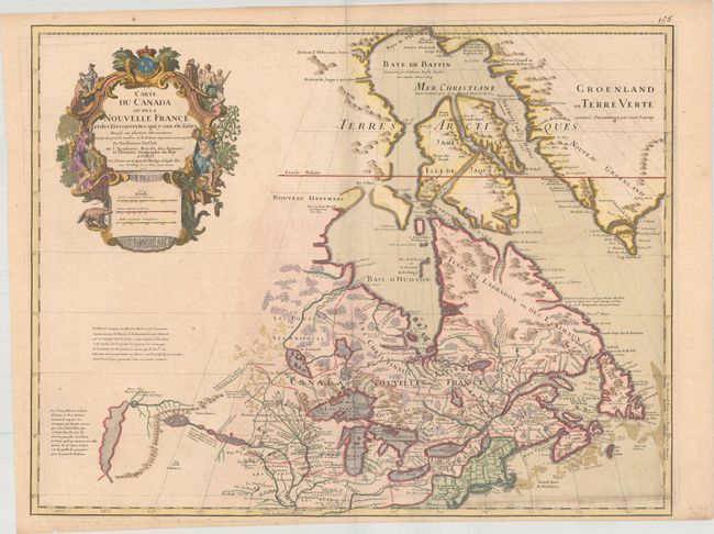
Auction 168, Lot 126
Subject: Colonial Northeastern United States & Canada, Great Lakes
Delisle, Guillaume
Carte du Canada ou de la Nouvelle France et des Decouvertes qui y ont ete faites…, 1718
Size: 25.5 x 19.7 inches (64.8 x 50 cm)
Estimate: $2,200 - $2,500
Delisle's Seminal Map of Canada and the Great Lakes
Sold for: $1,600
Closed on 6/6/2018
Auction 168, Lot 127
Subject: Colonial Northeastern United States & Canada, Great Lakes
Robert de Vaugondy, Didier
Partie de l'Amerique Septent? qui Comprend la Nouvelle France ou le Canada, 1755
Size: 23.5 x 18.6 inches (59.7 x 47.2 cm)
Estimate: $550 - $650
Sold for: $400
Closed on 6/6/2018
Auction 168, Lot 128
Subject: Central United States & Canada
U.S. Government
[17 Maps in Report] Boundary Between the United States and Great Britain. Message from the President of the United States..., 1838
Size: 5.5 x 8.8 inches (14 x 22.4 cm)
Estimate: $220 - $250
Sold for: $275
Closed on 6/6/2018
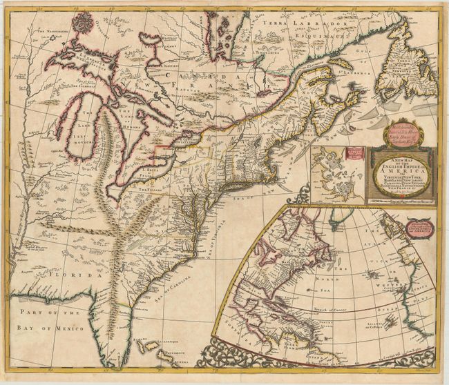
Auction 168, Lot 129
Subject: Colonial Eastern United States & Canada
Senex, John
A New Map of the English Empire in America viz Virginia New York Maryland New Iarsey Carolina New England Pennsylvania Newfoundland New France &c, 1719
Size: 23.6 x 19.9 inches (59.9 x 50.5 cm)
Estimate: $2,400 - $3,000
Important Map of the American Colonies
Sold for: $3,500
Closed on 6/6/2018
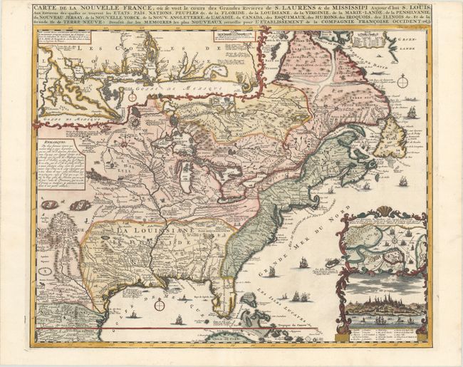
Auction 168, Lot 130
Subject: Colonial Eastern United States & Canada
Chatelain, Henry Abraham
Carte de la Nouvelle France, ou se Voit le Cours des Grandes Rivieres de S. Laurens & de Mississipi Aujour d'hui S. Louis, aux Environs des-quelles se Trouvent les Etats, Pais, Nations, Peuples &c..., 1720
Size: 19.4 x 16.6 inches (49.3 x 42.2 cm)
Estimate: $3,000 - $3,750
One of the Most Informative 18th Century Maps of the French Possessions in North America
Sold for: $2,200
Closed on 6/6/2018
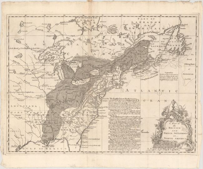
Auction 168, Lot 131
Subject: Colonial Eastern United States & Canada
Phinn, Thomas
A Map of the British and French Settlements in North America, 1755
Size: 15 x 10.9 inches (38.1 x 27.7 cm)
Estimate: $475 - $600
Sold for: $320
Closed on 6/6/2018
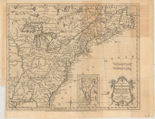
Auction 168, Lot 132
Subject: Colonial Eastern United States & Canada
Kitchin, Thomas
A New Map of the British Dominions in North America; with the Limits of the Governments Annexed Thereto by the Late Treaty of Peace, and Settled by Proclamation, October 7th, 1763, 1763
Size: 11.9 x 9.5 inches (30.2 x 24.1 cm)
Estimate: $325 - $400
Sold for: $240
Closed on 6/6/2018
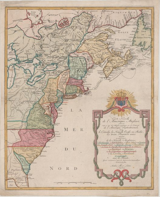
Auction 168, Lot 133
Subject: Colonial Eastern United States & Canada
Lotter, Mathias Albrecht
Carte Nouvelle de l'Amerique Angloise Contenant tout ce que les Anglois Possedent sur le Continent de l'Amerique Septentrionale Savoir le Canada, la Nouvelle Ecosse ou Acadie, les Treize Provinces Unies..., 1776
Size: 19.3 x 23.6 inches (49 x 59.9 cm)
Estimate: $1,100 - $1,400
Sold for: $1,100
Closed on 6/6/2018
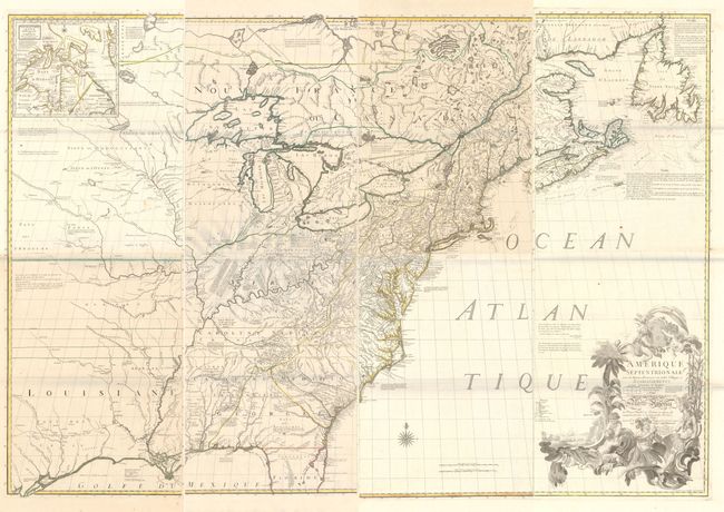
Auction 168, Lot 134
Subject: Colonial Eastern United States & Canada
Mitchell/Le Rouge
[On 8 Sheets] Amerique Septentrionale avec les Routes, Distances en Miles, Villages et Etablissements... / North America..., 1777
Size: 19 x 53 inches (48.3 x 134.6 cm)
Estimate: $10,000 - $13,000
Third French Edition of Mitchell's Monumental Map
Sold for: $7,500
Closed on 6/6/2018
Auction 168, Lot 135
Subject: Colonial Eastern United States & Canada
Sotzmann, Daniel Friedrich
Die Vereinigten Staaten von Nord-America. Nach der von Wm. Faden 1783 herausgegebenen Charte / Les Etats Unis de l'Amerique Septentrionale d'Apres la Carte de Wm. Faden Publiee a Londres en 1783..., 1785
Size: 10 x 7.6 inches (25.4 x 19.3 cm)
Estimate: $600 - $800
Rare, Multi-Lingual Reduced Version of Faden's Map of 1783
Unsold
Closed on 6/6/2018
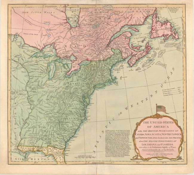
Auction 168, Lot 136
Subject: Eastern United States & Canada
Laurie & Whittle
The United States of America with the British Possessions of Canada, Nova Scotia, New Brunswick and Newfoundland Divided with the French, Also the Spanish Territories of Louisiana and Florida..., 1794
Size: 19.9 x 17.8 inches (50.5 x 45.2 cm)
Estimate: $750 - $900
Sold for: $1,000
Closed on 6/6/2018
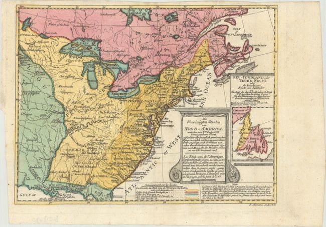
Auction 168, Lot 137
Subject: Eastern United States & Canada
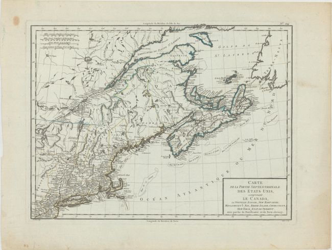
Tardieu, Pierre Francois
Carte de la Partie Septentrionale des Etats Unis, Comprenant le Canada, la Nouvelle Ecosse, New Hampshire, Massachuset's Bay, Rhode-Island, Connecticut, New-Yorck, Etat de Vermont..., 1797
Size: 16.8 x 12.6 inches (42.7 x 32 cm)
Estimate: $240 - $300
Sold for: $180
Closed on 6/6/2018
Auction 168, Lot 138
Subject: Eastern United States & Canada
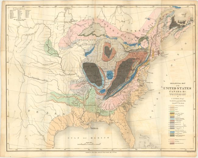
Lyell, Charles
Geological Map of the United States Canada &c. Compiled from the State Surveys of the U.S. and Other Sources [with] Travels in North America, in the Years 1841-2; with Geological Observations on the United States, Canada, and Nova Scotia, 1845
Size: 19.6 x 15.2 inches (49.8 x 38.6 cm)
Estimate: $750 - $900
First American Edition of Lyell's Important Account & Geological Map
Sold for: $750
Closed on 6/6/2018
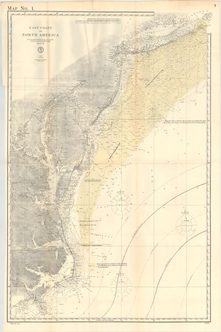
Auction 168, Lot 139
Subject: Eastern United States & Canada
U.S. Hydrographic Office
[Lot of 3] East Coast of North America [and] North East Coast of North America Sheet II [and] Sheet III [and] The River & Gulf of St. Lawrence, Newfoundland, Nova Scotia, and the Banks Adjacent, from the English Admiralty & French Marine Surveys, 1878
Size: See Description
Estimate: $250 - $325
Sold for: $100
Closed on 6/6/2018
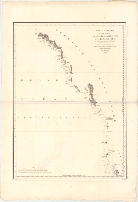
Auction 168, Lot 140
Subject: Western United States & Canada
La Perouse, Comte Jean F. Galoup, de
Carte Generale d'une Partie de la Cote du Nord-Ouest de l'Amerique Reconnue par les Fregates Francaises la Boussole et l'Astrolabe, 1797
Size: 19.4 x 26.9 inches (49.3 x 68.3 cm)
Estimate: $275 - $350
Sold for: $190
Closed on 6/6/2018
28 lots