Subject: Colonial Northeastern United States & Canada
Period: 1682 (published)
Publication: Le Monde ou la Geographie Universelle
Color: Hand Color
Size:
4.8 x 3.8 inches
12.2 x 9.7 cm
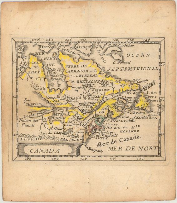
This little map is derived from Sanson's influential Le Canada ou Nouvelle France of 1656. The map is centered on the French possessions in North America with emphasis on the Great Lakes. Lake Superior and Michigan (Lac des puants) are shown with open-ended western shores and Lake Erie (Lac du Chat) is located too far south. In northern Canada, a sea route is shown through the northwest part of Hudson Bay. The British, Dutch and Swedish colonies are depicted along the eastern seaboard from Virginia to Newfoundland (I. de Terre Neuve). This is the third state with several additional names including Mer de Canada, 3 Rivieres, al=Manhate, B. Chesapeak and Boston. Pierre Duval was Nicolas Sanson's nephew and pupil. He published a wide range of atlases and individual maps including a fine miniature world geography with many of the maps based on Sanson.
References: Burden #351; Kershaw #141; McCorkle #661.1; King (2nd ed) pp. 132-135; Pastoureau, Duval XI Fa.
Condition: B+
On watermarked paper with a light dampstain at left. There are remnants of cello tape along the top edge of the sheet on verso with some minor staining on recto far from the image.