Subject: United States
Period: 1856 (dated)
Publication:
Color: Hand Color
Size:
39.9 x 28.9 inches
101.3 x 73.4 cm
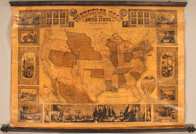
A terrific wall map published at a time when many territorial borders were at their most unique configurations. Utah is a large territory that includes all of Nevada and most of Colorado, and New Mexico extends between Texas and California. In California, the Gold Region is prominently depicted. Oregon and Washington territories extend to the Continental Divide. Nebraska extends from Kansas to the Canadian border and includes today's Montana, Wyoming and much of the Dakotas. Minnesota Territory includes the eastern Dakotas, and Oklahoma is Indian Territory. There is an extensive railroad network throughout the East, with wagon roads and emigrant routes shown in the western territories. Surrounding the map is a series of 15 vignettes including the signing of the Declaration of Independence, the Landing of Columbus, and the Battle of Monterey. Linen backed with original rollers.
References:
Condition: B
Original color with a dampstain at top left and light toning due to the varnish. There are numerous cracks with a tiny chip in the inset map of Mexico and two small chips in the vignette at bottom. The rollers are present and attached but loose in a few places.