Subject: Colonial Northeastern United States & Canada, Great Lakes
Period: 1718 (circa)
Publication:
Color: Hand Color
Size:
25.5 x 19.7 inches
64.8 x 50 cm
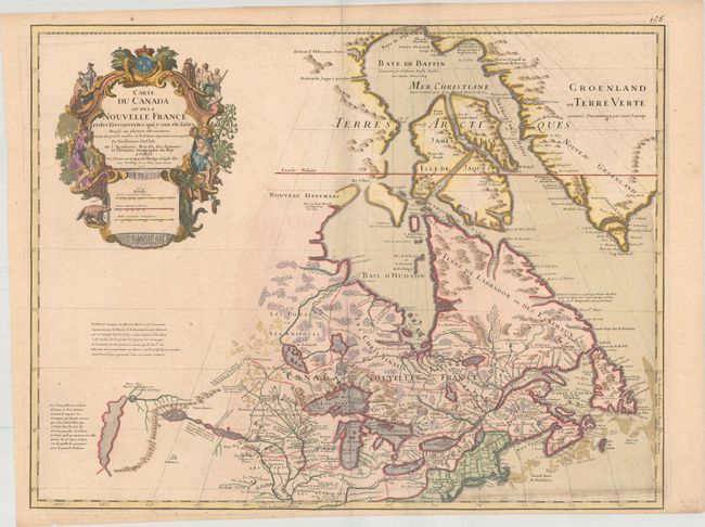
Delisle's map of Canada and the Great Lakes is one of the most outstanding and influential maps of the eighteenth century. The Great Lakes are portrayed correctly for the first time, and Detroit marks its debut on this map, only two years after its founding. Delisle's cartography is very meticulous and adds new information from Joliet, Franquelin, and the Jesuit explorers. It correctly positions the Ohio River but confuses its name with the Wabash River. West of the Mississippi Lahontan's fictitious Riviere Longue is prominently depicted. In Canada special attention is given to the rivers and lakes between Hudson Bay and the St. Lawrence, and Lac de Assenipoils (Lake Winnipeg) connects to Hudson Bay. Sanson's three islands of the Arctic are retained. Exquisite cartouche with a beaver, natives (one of whom is bearing a scalp), a priest, and friars, engraved by Guerard. This is the fifth state of the map, with et Premier Geographe du Roy added to Delisle imprint.
References: Kershaw #312; Schwartz & Ehrenberg p. 135-137 & Plt. 80; Tooley (Amer) #38 & Plt. 10; Karpinski pp. 118 & 123.
Condition: B+
A nice impression on watermarked paper with minor soiling at bottom right. There are two light extraneous creases to the right of the centerfold, one of which has been reinforced on verso with hinge tape.