Subject: United States, Texas
Period: 1845 (dated)
Publication: Meyer's Hand-Atlas
Color: Hand Color
Size:
15.2 x 11.4 inches
38.6 x 29 cm
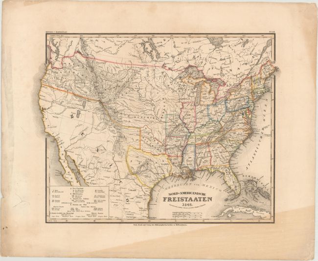
The United States and Great Britain established in 1818 joint claim over the Oregon Territory - the region north of Spanish controlled Upper California up to the southern boundary of Russia's Alaska Territory at North latitude 54°40'. By the late 1830's this arrangement was beginning to fall apart.
In the 1840's the expansionist Democrats, including their 1844 presidential candidate, James Polk, claimed the entire region for the United States. Their expansionist desires were expressed by Polk's famous campaign slogan, "Fifty-four Forty or Fight!" The slogan also became a rally cry for Americans desiring to settle the territory. Following Polk's election, the dispute was resolved by the 1846 Treaty of Oregon, which struck a compromise that fixed the U.S./Canadian boundary at 49º North.
An attractive map of the United States just prior to the Mexican-American War, showing a small Republic of Texas with its southwestern border on the Nueces River. The native regions are named in the Midwest and West, including Distrikt Huron, Sious Distrikt, Ozark Distrikt, Osagen Distrikt, and Mandanen Distrikt. The Oregon Distrikt is diminished by British claims on the Columbia River.
References:
Condition: B+
Original outline color with a triangular band of toning at bottom right, an archivally repaired tear in the left blank margin, and additional light toning and soiling along the edges of the sheet.