Filtered by Category:United States(Show All Categories)
Showing results for:Auction 119
Catalog Archive
246 lots
Page 1 of 5
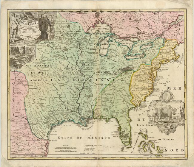
Auction 119, Lot 117
Subject: Colonial North America
Homann, Johann Baptist
Amplissimae Regionis Mississipi seu Provinciae Ludovicianae…, 1730
Size: 22.8 x 19 inches (57.9 x 48.3 cm)
Estimate: $1,600 - $1,800
Sold for: $1,400
Closed on 5/9/2007
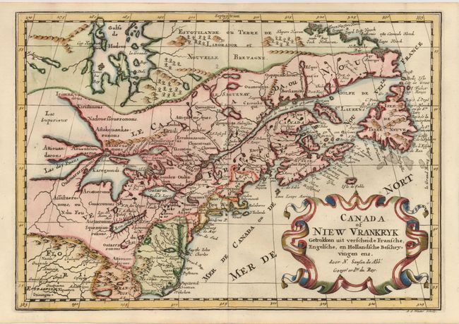
Auction 119, Lot 138
Subject: Colonial United States and Canada
Sanson, Nicolas
Canada of Niew Vrankryk Getrokken uit verscheide Fransche, Engelsche, en Hollandsche Beschryvingen enz, 1705
Size: 11.7 x 8.2 inches (29.7 x 20.8 cm)
Estimate: $750 - $950
Sold for: $650
Closed on 5/9/2007
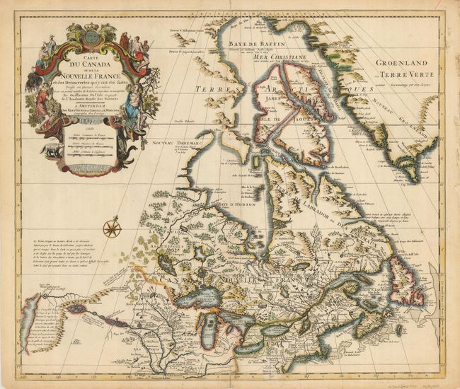
Auction 119, Lot 139
Subject: Colonial United States and Canada
Delisle/Covens & Mortier
Carte du Canada ou de la Nouvelle France…, 1730
Size: 22.5 x 19.3 inches (57.2 x 49 cm)
Estimate: $1,100 - $1,400
Sold for: $700
Closed on 5/9/2007
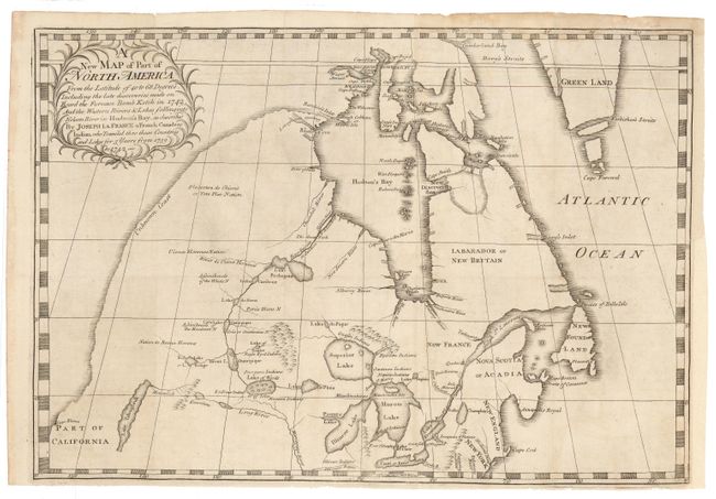
Auction 119, Lot 140
Subject: Colonial United States and Canada
La France, Joseph
A new Map of Part of North America From the Latitude of 40 to 68 Degrees. Including the late discoveries made on Board the Furnace Bomb Ketch in 1742…, 1744
Size: 18.5 x 13 inches (47 x 33 cm)
Estimate: $4,500 - $6,000
Sold for: $3,250
Closed on 5/9/2007
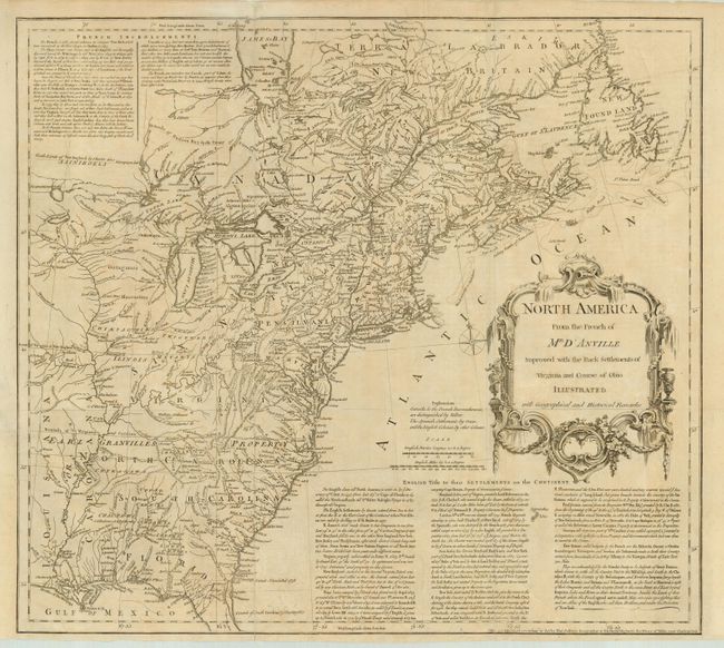
Auction 119, Lot 141
Subject: Colonial United States and Canada
Jefferys, Thomas
North America From the French of Mr. D'Anville Improved with the Back Settlements of Virginia and Course of Ohio Illustrated with Geographical and Historical Remarks, 1755
Size: 20 x 18 inches (50.8 x 45.7 cm)
Estimate: $1,300 - $1,600
Sold for: $1,200
Closed on 5/9/2007
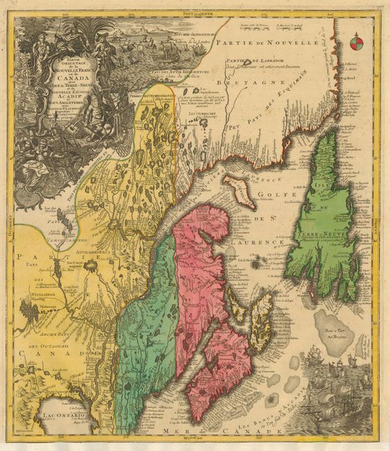
Auction 119, Lot 142
Subject: Colonial United States and Canada
Seutter/Lotter
Partie Orientale de la Nouvelle France ou du Canada avec l'Isle de Terre-Neuve et de Nouvelle Ecosse, Acadie et Nouv. Angleterre…, 1756
Size: 19.3 x 22.3 inches (49 x 56.6 cm)
Estimate: $1,000 - $1,300
Unsold
Closed on 5/9/2007
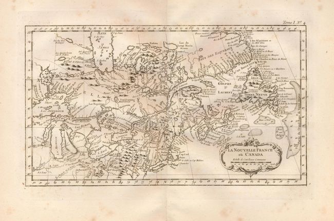
Auction 119, Lot 143
Subject: Colonial United States and Canada
Bellin, Jacques Nicolas
La Nouvelle France ou Canada, 1764
Size: 13.8 x 7.8 inches (35.1 x 19.8 cm)
Estimate: $240 - $300
Sold for: $150
Closed on 5/9/2007
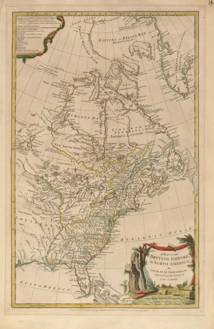
Auction 119, Lot 144
Subject: Colonial United States and Canada
Dunn, Samuel
A Map of the British Empire, in North America, 1776
Size: 11.8 x 18.8 inches (30 x 47.8 cm)
Estimate: $1,400 - $1,700
Sold for: $1,600
Closed on 5/9/2007
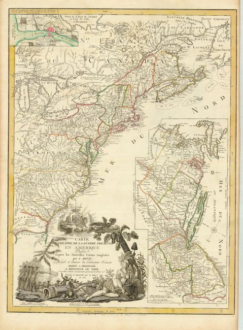
Auction 119, Lot 145
Subject: Colonial United States and Canada
Denis, Louis
Carte du Theatre de la Guerre Presente en Amerique Dressee d'apres les Nouvelles Cartes Anglaises, 1782
Size: 19.5 x 26.3 inches (49.5 x 66.8 cm)
Estimate: $3,000 - $4,000
Sold for: $5,500
Closed on 5/9/2007
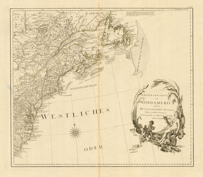
Auction 119, Lot 146
Subject: Canada & United States
Schraembl, Franz Anton
[2 Sheets] General Karte von Nordamerica samt den Westindischen Inseln Verfasst von Herrn Pownall, 1788
Size: 23 x 20 inches (58.4 x 50.8 cm)
Estimate: $800 - $950
Sold for: $600
Closed on 5/9/2007
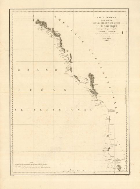
Auction 119, Lot 147
Subject: Western Canada & United States
La Perouse, Comte Jean F. Galoup, de
Carte Generale d'une Partie de la Cote du Nord-Ouest de l'Amerique reconnue par les Fregates Francaises la Boussole et l'Astrolabe, 1797
Size: 19.3 x 27 inches (49 x 68.6 cm)
Estimate: $150 - $250
Sold for: $90
Closed on 5/9/2007
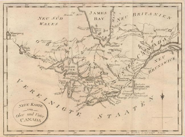
Auction 119, Lot 148
Subject: Canada & United States & Great Lakes
Stockdale, John
Neue Karte von Ober und Unter Canada, 1801
Size: 8.8 x 6.5 inches (22.4 x 16.5 cm)
Estimate: $120 - $160
Sold for: $60
Closed on 5/9/2007
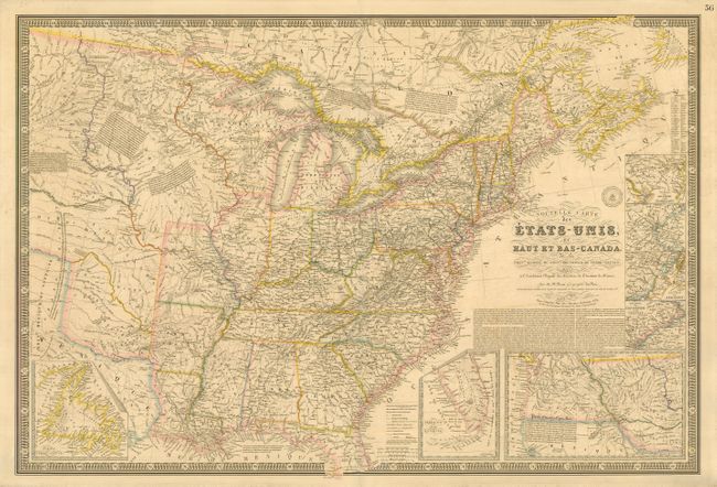
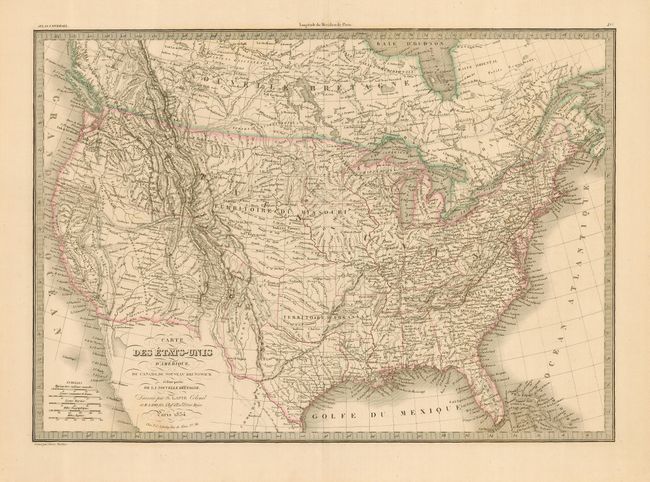
Auction 119, Lot 149
Subject: Canada & United States
Brue, Adrien Hubert
Nouvelle Carte des Etats-Unis, du Haut et Bas-Canada, de la Nouvle. Ecosse, du Nouvau. Brunswick, de Terre-Neuve &c., 1832
Size: 36.8 x 24.8 inches (93.5 x 63 cm)
Estimate: $700 - $800
Unsold
Closed on 5/9/2007
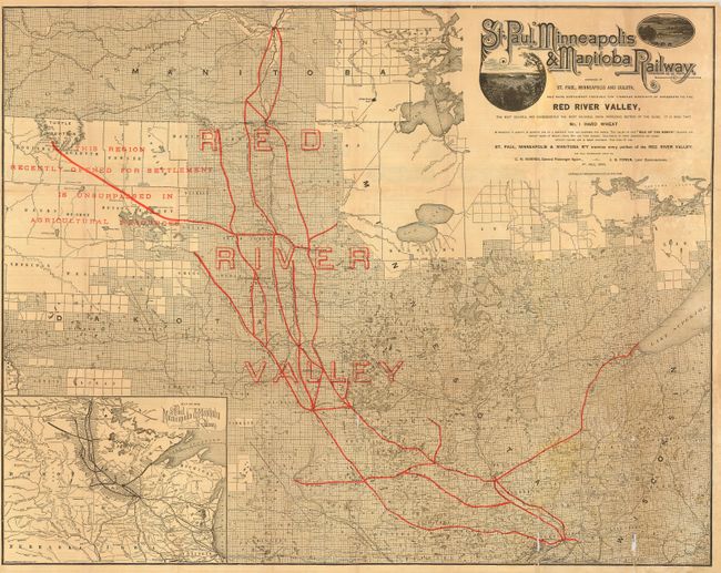
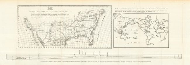
Auction 119, Lot 150
Subject: Central United States - Manitoba
Railroad Companies, (Various)
St. Paul, Minneapolis & Manitoba Railway, 1884
Size: 30.3 x 24 inches (77 x 61 cm)
Estimate: $150 - $200
Sold for: $400
Closed on 5/9/2007
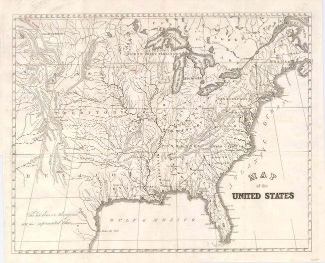
Auction 119, Lot 151
Subject: United States
U.S. Government
[Lot of 2] Map of the United States [and] U. States, 1839
Size: See Description
Estimate: $120 - $140
Unsold
Closed on 5/9/2007
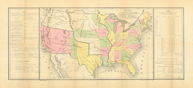
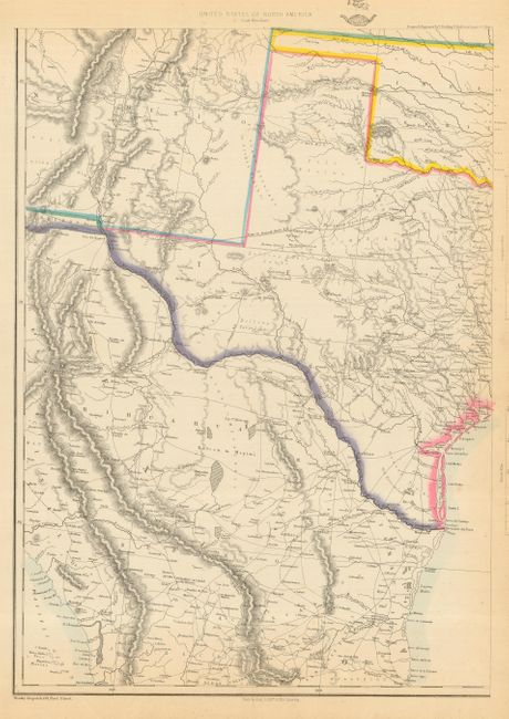
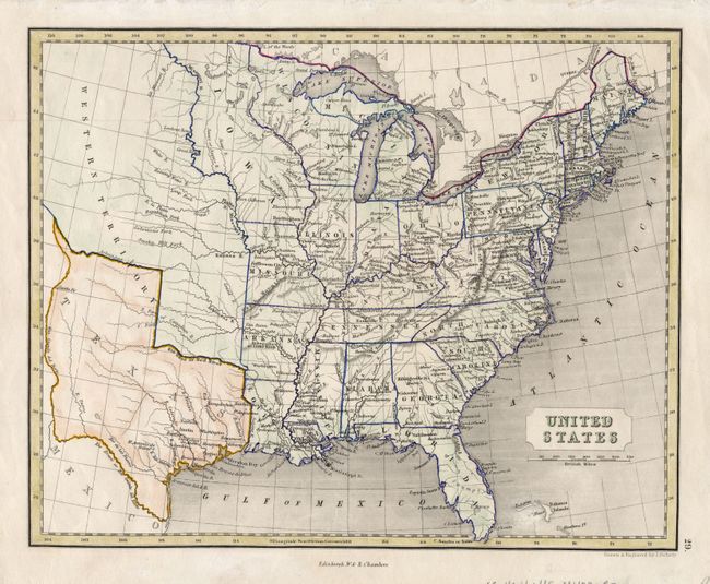
Auction 119, Lot 152
Subject: United States, Texas
Gilman, E.
[United States], 1848
Size: 21.5 x 13.8 inches (54.6 x 35.1 cm)
Estimate: $600 - $800
Sold for: $550
Closed on 5/9/2007
Auction 119, Lot 153
Subject: United States
U.S. Government
[Lot of 4 - Early Railroad Maps], 1848
Size: See Description
Estimate: $200 - $300
Sold for: $210
Closed on 5/9/2007
Auction 119, Lot 154
Subject: United States
Lapie, Alexander Emile & Pierre
Carte des Etats-Unis d'Amerique, du Canada, du Nouveau Brunswick et d'une partie de la Nouvelle Bretagne, 1854
Size: 21.5 x 15.3 inches (54.6 x 38.9 cm)
Estimate: $200 - $250
Unsold
Closed on 5/9/2007
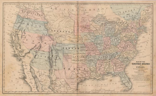
Auction 119, Lot 155
Subject: United States
Burgess, Daniel
[Lot of 2] Map of the United States and Canada, Designed to Accompany Smith's Geography for Schools [and] United States, 1855-57
Size: See Description
Estimate: $100 - $200
Sold for: $160
Closed on 5/9/2007
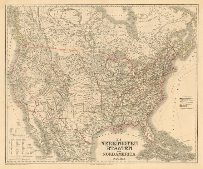
Auction 119, Lot 156
Subject: United States
Weimar Geographisches Institut
Die Vereinigten Staaten von Nord America nebst Canada, 1858
Size: 25 x 21 inches (63.5 x 53.3 cm)
Estimate: $160 - $200
Sold for: $170
Closed on 5/9/2007
Auction 119, Lot 157
Subject: United States
Ettling, Theodor
[Lot of 6] United States of North America, 1858-63
Size: 12 x 16.8 inches (30.5 x 42.7 cm)
Estimate: $400 - $600
Unsold
Closed on 5/9/2007
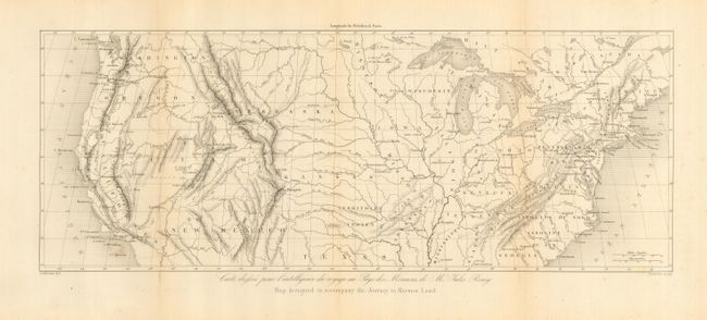
Auction 119, Lot 158
Subject: United States
Remy, Jules
Map designed to accompany the Journey to Mormon Land, 1861
Size: 17.5 x 6.8 inches (44.5 x 17.3 cm)
Estimate: $170 - $250
Sold for: $130
Closed on 5/9/2007
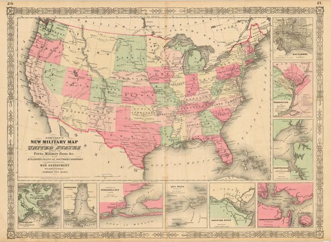
Auction 119, Lot 159
Subject: United States
Johnson & Ward
New Military Map of the United States Showing the Forts, Military Posts, &c with Enlarged Plans of Southern Harbors, 1864
Size: 22.5 x 15.8 inches (57.2 x 40.1 cm)
Estimate: $140 - $180
Sold for: $200
Closed on 5/9/2007
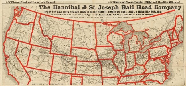
Auction 119, Lot 160
Subject: United States
Railroad Companies, (Various)
The Hannibal & St. Joseph Rail Road Company Offer for Sale…, 1867
Size: 26.8 x 12 inches (68.1 x 30.5 cm)
Estimate: $200 - $300
Sold for: $350
Closed on 5/9/2007
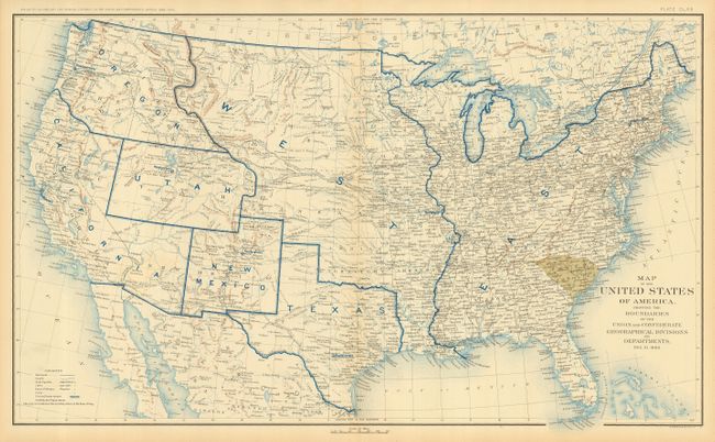
Auction 119, Lot 161
Subject: United States
U.S. Government
[Lot of 10] Map of the United States of America, Showing the Boundaries of the Union and Confederate Geographical Divisions and Departments [1861-1865], 1891-95
Size: 27.7 x 16.5 inches (70.4 x 41.9 cm)
Estimate: $1,000 - $1,500
Sold for: $1,400
Closed on 5/9/2007
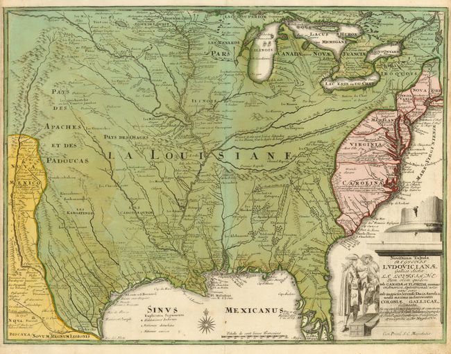
Auction 119, Lot 162
Subject: Colonial United States
Weigel, Christopher
Novissima Tabula Regionis Ludovicianae Gallice dicta la Louisiane…, 1734
Size: 16 x 12.3 inches (40.6 x 31.2 cm)
Estimate: $1,400 - $1,800
Sold for: $1,000
Closed on 5/9/2007
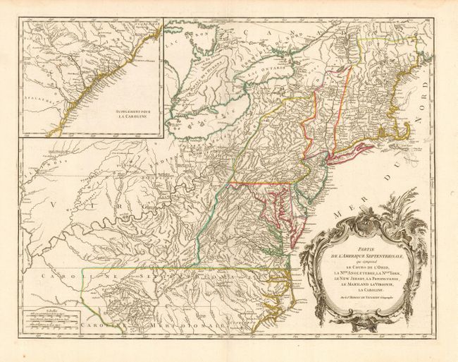
Auction 119, Lot 163
Subject: Colonial United States
Robert de Vaugondy, Gilles
Partie de l'Amerique Septentrionale, qui Comprend le Cours de l'Ohio, la Nlle Angleterre, la Nlle York, le New Jersey, la Pensylvanie, la Maryland la Virginie, la Caroline, 1768
Size: 24.5 x 18.8 inches (62.2 x 47.8 cm)
Estimate: $950 - $1,100
Sold for: $700
Closed on 5/9/2007
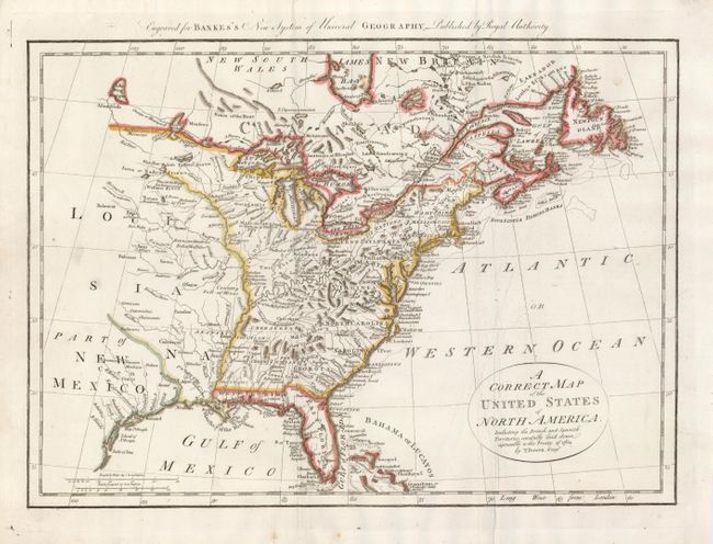
Auction 119, Lot 164
Subject: Colonial United States
Bowen, Thomas
A Correct Map of the United States of North America, Including the British and Spanish Territories, carefully laid down agreeable to the Treaty of 1784, 1785
Size: 17.4 x 12.1 inches (44.2 x 30.7 cm)
Estimate: $325 - $400
Sold for: $350
Closed on 5/9/2007
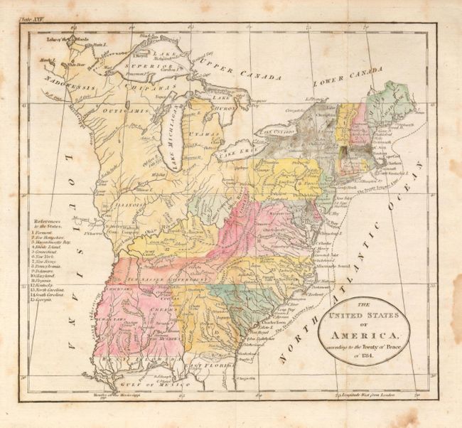
Auction 119, Lot 165
Subject: United States - Eastern
Russell, John C.
The United States of America, according to the Treaty of Peace of 1784, 1795
Size: 8 x 7 inches (20.3 x 17.8 cm)
Estimate: $120 - $160
Sold for: $95
Closed on 5/9/2007
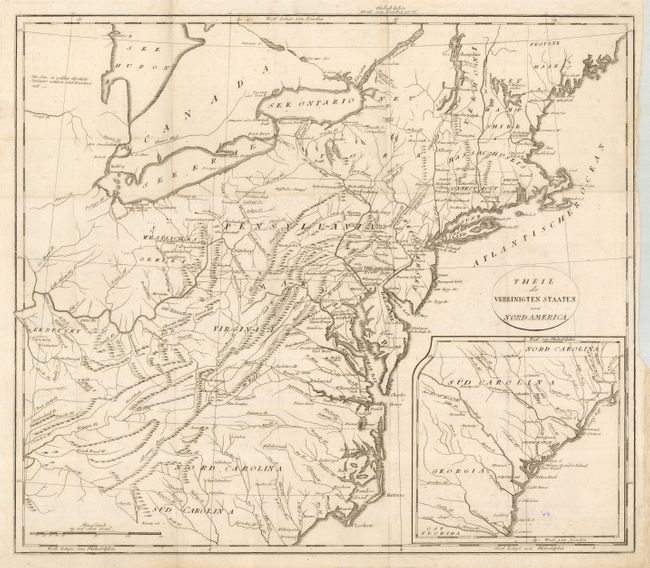
Auction 119, Lot 166
Subject: United States - Eastern
Weld, Isaac
Theil der Vereinigten Staaten von Nord America, 1805
Size: 18.3 x 15.8 inches (46.5 x 40.1 cm)
Estimate: $200 - $300
Sold for: $150
Closed on 5/9/2007
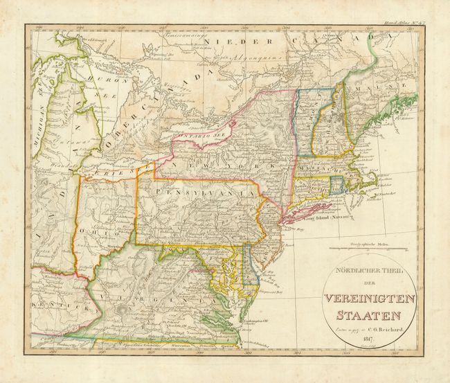
Auction 119, Lot 167
Subject: United States - Eastern
Reichard, Christian Gottlieb Theoph
Nordlicher Theil der Vereinigten Staaten, 1817
Size: 13.3 x 11 inches (33.8 x 27.9 cm)
Estimate: $250 - $300
Sold for: $180
Closed on 5/9/2007
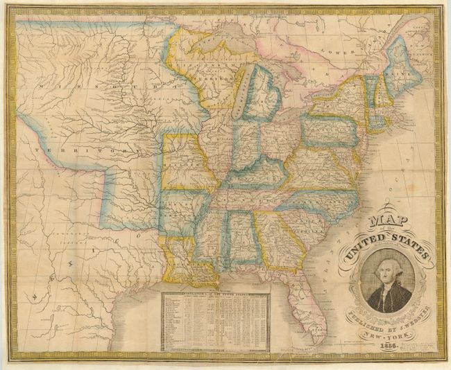
Auction 119, Lot 168
Subject: United States - Eastern
Phelps, Humphrey
Map of the United States Published by J. Webster, 1836
Size: 19.8 x 19 inches (50.3 x 48.3 cm)
Estimate: $750 - $1,000
Sold for: $500
Closed on 5/9/2007
Auction 119, Lot 169
Subject: United States - Eastern
Gellatly, J.
United States, 1845
Size: 10 x 8 inches (25.4 x 20.3 cm)
Estimate: $200 - $250
Sold for: $150
Closed on 5/9/2007
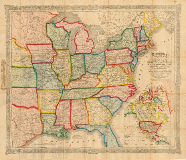
Auction 119, Lot 170
Subject: United States - Eastern
Fisher, Richard Swainson
Dinsmore's Complete Map of the Railroads & Canals of the United States & Canada Carefully Compiled from Authentic Sources, 1856
Size: 30.5 x 25 inches (77.5 x 63.5 cm)
Estimate: $1,000 - $1,400
Unsold
Closed on 5/9/2007
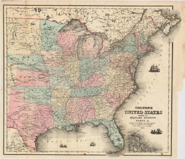
Auction 119, Lot 171
Subject: United States - Eastern, Central
Colton, Joseph Hutchins
Colton's United States shewing the Military Stations Forts &c., 1861
Size: 16 x 15 inches (40.6 x 38.1 cm)
Estimate: $300 - $350
Sold for: $275
Closed on 5/9/2007
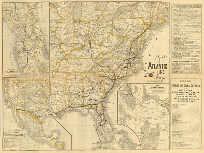
Auction 119, Lot 172
Subject: United States - Eastern
Railroad Companies, (Various)
Map of the Atlantic Coast Line of Railways & Connections, 1891
Size: 17.3 x 15.5 inches (43.9 x 39.4 cm)
Estimate: $200 - $250
Sold for: $350
Closed on 5/9/2007
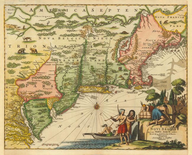
Auction 119, Lot 173
Subject: Colonial - New England & Mid-Atlantic
Montanus, Arnoldus
Novi Belgii, quod nunc Novi Jorck Vocatur, Novae qz. Angliae & Partis Virginiae Accuratissima et Novissima Delineatio, 1671
Size: 14.3 x 11.3 inches (36.3 x 28.7 cm)
Estimate: $1,600 - $1,900
Sold for: $1,700
Closed on 5/9/2007
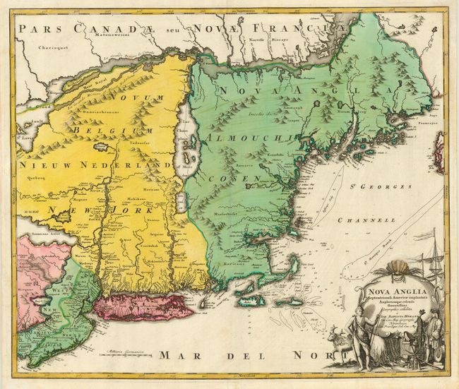
Auction 119, Lot 174
Subject: Colonial New England
Homann, Johann Baptist
Nova Anglia Septentrionali Americae implantata Anglorumque coloniis florentissima, 1720
Size: 23 x 19.2 inches (58.4 x 48.8 cm)
Estimate: $2,000 - $2,300
Sold for: $1,200
Closed on 5/9/2007
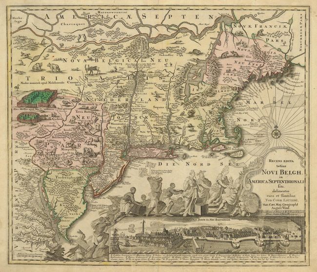
Auction 119, Lot 175
Subject: Colonial New England
Seutter/Lotter
Recens Edita totius Novi Belgii, in America Septentrionali siti, delineatio cura et Sumtibus, 1757
Size: 22.6 x 19.6 inches (57.4 x 49.8 cm)
Estimate: $4,000 - $5,000
Unsold
Closed on 5/9/2007
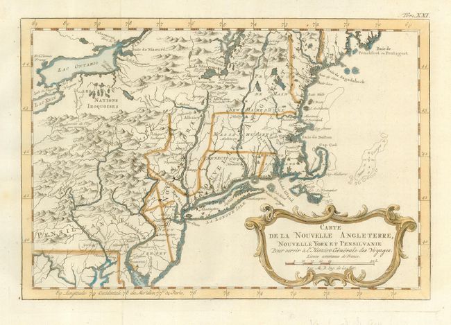
Auction 119, Lot 176
Subject: Colonial New England and Mid-Atlantic
Bellin, Jacques Nicolas
Carte de la Nouvelle Angleterre, Nouvelle Yorck, Pensilvanie…, 1757
Size: 11.5 x 7.8 inches (29.2 x 19.8 cm)
Estimate: $350 - $450
Sold for: $190
Closed on 5/9/2007
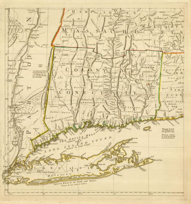
Auction 119, Lot 177
Subject: Colonial New England
Jefferys, Thomas
[A Map of the Most Inhabited Part of New England], 1777
Size: 19 x 20 inches (48.3 x 50.8 cm)
Estimate: $1,000 - $1,200
Sold for: $750
Closed on 5/9/2007
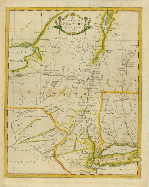
Auction 119, Lot 178
Subject: Northeastern United States, New York
Anon.
An accurate Map of New York in North America, from a late Survey, 1780
Size: 10.5 x 13 inches (26.7 x 33 cm)
Estimate: $300 - $350
Sold for: $220
Closed on 5/9/2007
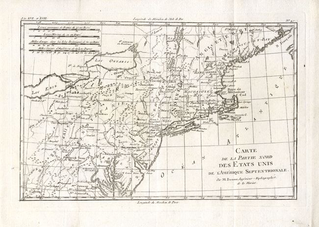
Auction 119, Lot 179
Subject: United States - New England
Bonne, Rigobert
Carte de la Partie Nord, des Etats Unis, de l'Amerique Septentrionale, 1783
Size: 12.7 x 8.4 inches (32.3 x 21.3 cm)
Estimate: $180 - $200
Sold for: $120
Closed on 5/9/2007
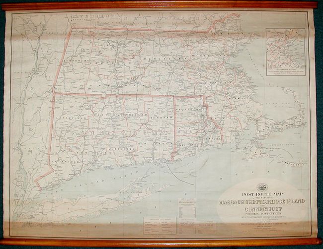
Auction 119, Lot 180
Subject: United States - New England
U.S. Government
Post Route Map of the States of Massachusetts, Rhode Island & Connecticut, 1911
Size: 44.5 x 33.5 inches (113 x 85.1 cm)
Estimate: $150 - $100
Sold for: $110
Closed on 5/9/2007
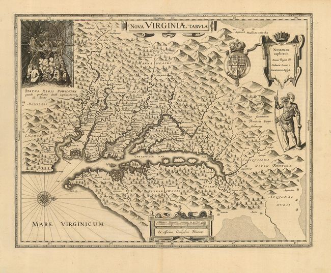
Auction 119, Lot 181
Subject: Colonial Chesapeake Bay
Hondius/Blaeu
Nova Virginiae Tabula, 1640
Size: 18.7 x 14.7 inches (47.5 x 37.3 cm)
Estimate: $3,250 - $3,750
Sold for: $2,400
Closed on 5/9/2007
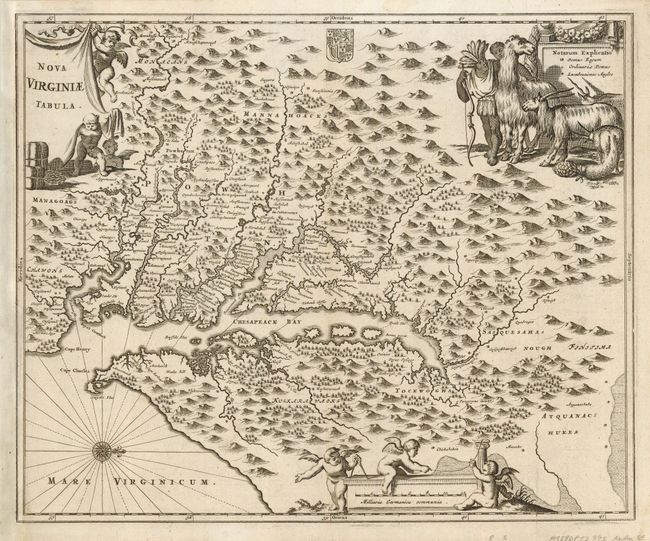
Auction 119, Lot 182
Subject: Colonial Chesapeake Bay
Montanus, Arnoldus
Nova Virginiae Tabula, 1671
Size: 13.8 x 11.3 inches (35.1 x 28.7 cm)
Estimate: $1,300 - $1,500
Sold for: $950
Closed on 5/9/2007
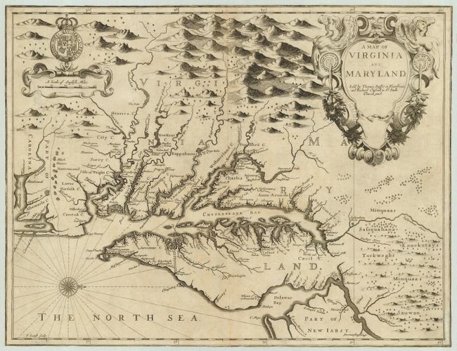
Auction 119, Lot 183
Subject: Colonial Chesapeake Bay
Speed/Lamb
A Map of Virginia and Maryland, 1676
Size: 19.3 x 14.8 inches (49 x 37.6 cm)
Estimate: $4,500 - $5,500
Sold for: $3,250
Closed on 5/9/2007
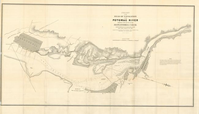
Auction 119, Lot 184
Subject: United States - Mid-Atlantic
U.S. War Department
Chart of the Head of Navigation of the Potomac River Shewing the Route of the Alexandria Canal Made in Pursuance of a Resolution of the Alexa. Canal Company Oct. 1838…, 1838
Size: 36 x 19 inches (91.4 x 48.3 cm)
Estimate: $200 - $250
Sold for: $800
Closed on 5/9/2007
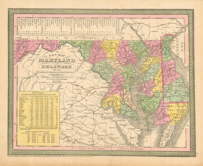
Auction 119, Lot 185
Subject: Maryland and Delaware
Desilver, Charles
A New Map of Maryland and Delaware with their Canals, Roads & Distances, 1855
Size: 13.3 x 10 inches (33.8 x 25.4 cm)
Estimate: $110 - $130
Sold for: $75
Closed on 5/9/2007
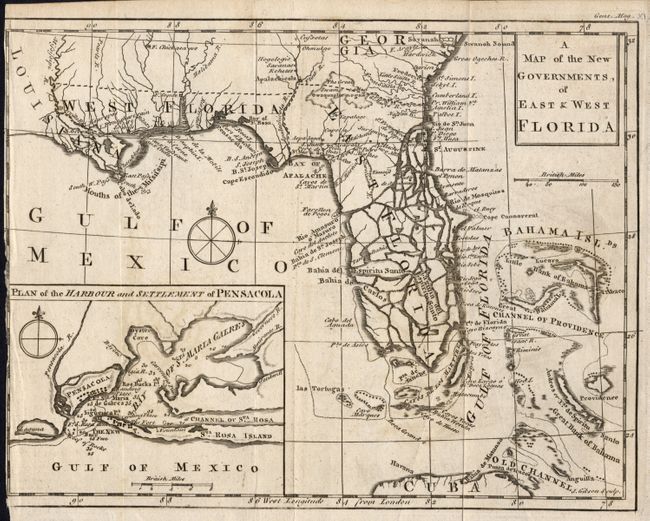
Auction 119, Lot 186
Subject: Gulf Coast and Florida
Gibson, John
A Map of the New Governments, of East & West Florida, 1763
Size: 9.8 x 7.5 inches (24.9 x 19.1 cm)
Estimate: $200 - $250
Sold for: $240
Closed on 5/9/2007
246 lots
Page 1 of 5