Subject: Colonial United States and Canada
Period: 1776 (dated)
Publication:
Color: Hand Color
Size:
11.8 x 18.8 inches
30 x 47.8 cm
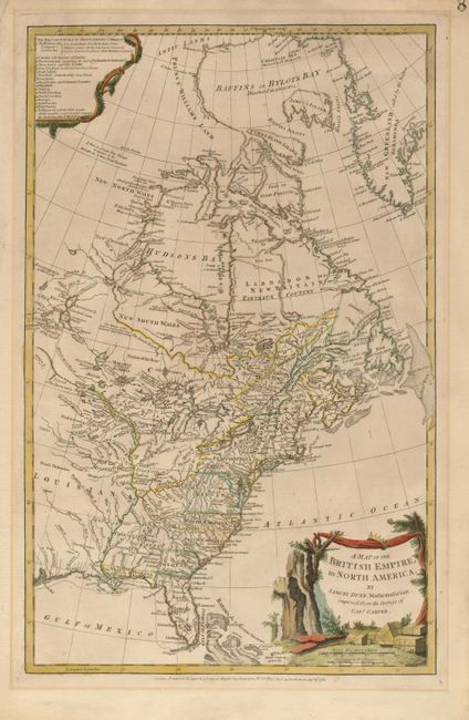
This uncommon map is based on the surveys of Captain Jonathan Carver and was issued during the Revolutionary War period. This particular map was issued in both The American Military Pocket Atlas, also known as the Holster Atlas carried by British redcoats, and Thomas Jeffrey's American Atlas. The western boundaries of most of the thirteen colonies are left open, but the colonial claims extend to the Mississippi River. A key at the upper left lists the British territories claimed in North America, including the Hudson Bay Company lands, the Reserved Lands west of Appalachia to the Ohio and Mississippi rivers, in addition to both East and West Florida. A notation west of Hudson Bay notes that if there is a Northwest Passage, it would be through one of the inlets attached to Hudson Bay. The decorative landscape cartouche depicts the boxes of tea from the Boston Tea Party of 1773 as well as the paddles the Bostonians used to push any recalcitrant floating boxes back into the sea. A fascinating map that appears with a different title and information after the birth of the United States.
References: Stevens & Tree #53 (b); Sellers & Van Ee #129; Schwartz & Ehrenberg pg. 190.
Condition: A
Lovely impression and delicate original color. There is a minor mat burn in the blank margins, not affecting image. Toned on verso with tape residue from hinges at top. The paper is sound and supple.