Filtered by Category:Canada(Show All Categories)
Showing results for:Auction 185
Catalog Archive
36 lots
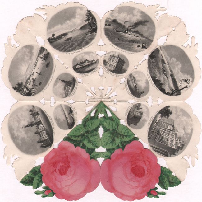
Auction 185, Lot 55
Subject: Cartographic Miscellany, Canada
The Canada Rose. Part. II, 1859
Size: 9.1 x 9.1 inches (23.1 x 23.1 cm)
Estimate: $400 - $500
Views of Canada in a Souvenir Rose
Unsold
Closed on 11/17/2021
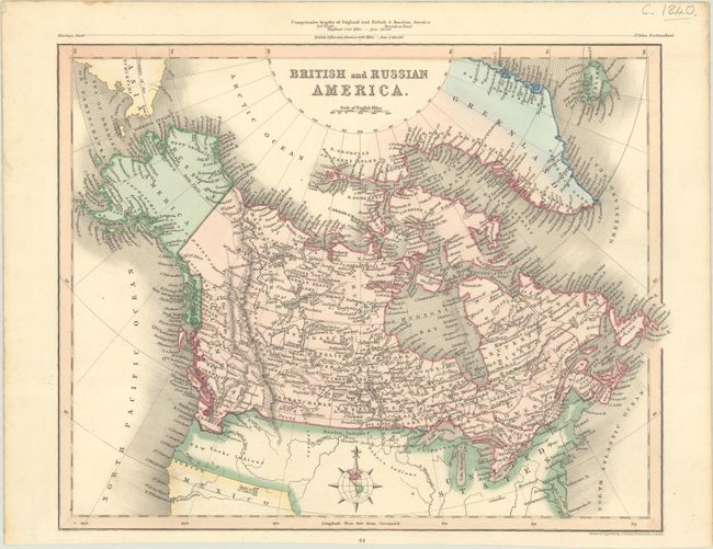
Auction 185, Lot 115
Subject: Canada
[Lot of 2] British and Russian America [and] British North America, 1834-40
Size: See Description
Estimate: $100 - $130
Sold for: $170
Closed on 11/17/2021
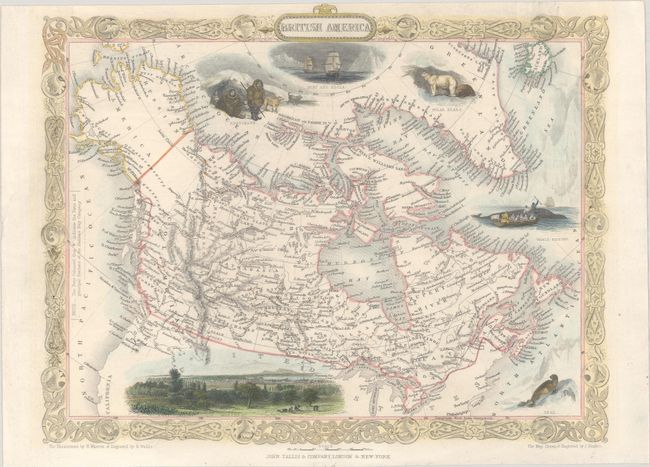
Auction 185, Lot 116
Subject: Canada
Tallis, John
British America, 1850
Size: 12.9 x 10 inches (32.8 x 25.4 cm)
Estimate: $120 - $150
Sold for: $180
Closed on 11/17/2021
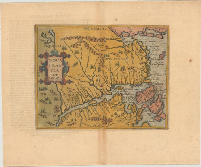
Auction 185, Lot 117
Subject: Eastern Canada
Metellus, Natalius Sequanus
Nova Francia et Canada, 1598
Size: 9.3 x 7.4 inches (23.6 x 18.8 cm)
Estimate: $1,300 - $1,600
Metellus's Rare Reduced Version of Wytfliet's Map of Eastern Canada
Sold for: $2,500
Closed on 11/17/2021
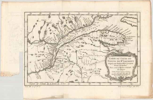
Auction 185, Lot 118
Subject: Eastern Canada, St. Lawrence River
Bellin, Jacques Nicolas
[Lot of 2] Carte du Cours du Fleuve de St. Laurent Depuis son Embouchure Jusqu'au Dessus de Quebec... [and] Suite de Cours du Fleuve de St. Laurent, Depuis Quebec Jusqua'au Lac Ontario..., 1757
Size: See Description
Estimate: $160 - $190
Sold for: $110
Closed on 11/17/2021
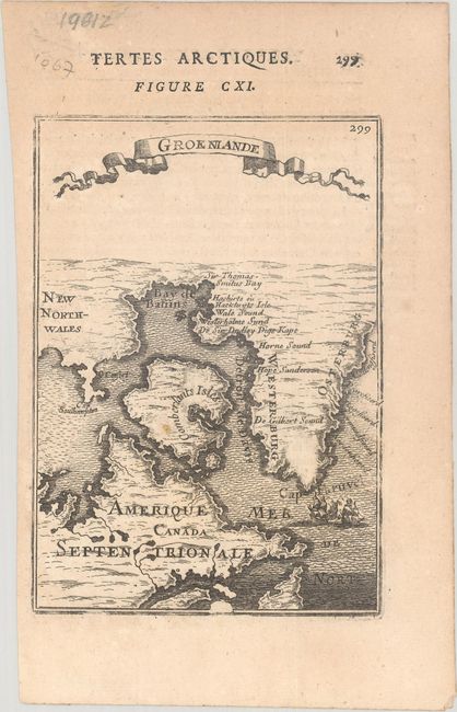
Auction 185, Lot 119
Subject: Northeastern Canada & Greenland
Mallet, Alain Manesson
Groenlande, 1683
Size: 4.1 x 5.9 inches (10.4 x 15 cm)
Estimate: $100 - $130
Sold for: $60
Closed on 11/17/2021
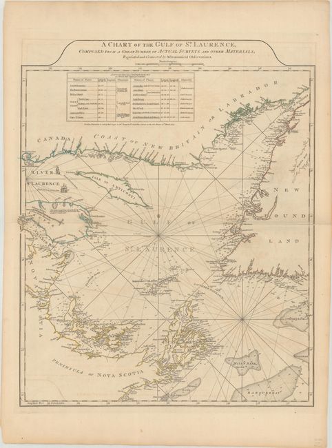
Auction 185, Lot 120
Subject: Gulf of St. Lawrence, Canada
Jefferys/Sayer & Bennett
A Chart of the Gulf of St. Laurence, Composed from a Great Number of Actual Surveys and Other Materials, Regulated and Connected by Astronomical Observations, 1775
Size: 19.7 x 24.1 inches (50 x 61.2 cm)
Estimate: $275 - $350
Sold for: $180
Closed on 11/17/2021
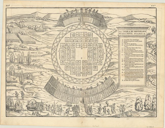
Auction 185, Lot 121
Subject: Montreal, Canada
Gastaldi/Ramusio
La Terra de Hochelaga nella Nova Francia, 1556
Size: 14.6 x 10.6 inches (37.1 x 26.9 cm)
Estimate: $2,200 - $2,500
The First Published Plan of a Settlement in North America
Sold for: $2,750
Closed on 11/17/2021
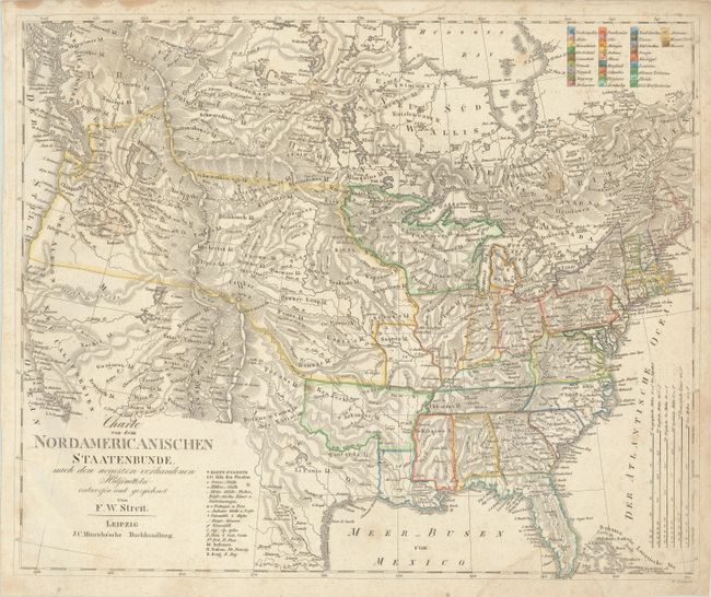
Auction 185, Lot 123
Subject: United States & Canada
Streit, Friedrich Wilhelm
Charte von dem Nordamericanischen Staatenbunde, nach den Neuesten Vorhandenen..., 1821
Size: 18.6 x 15.3 inches (47.2 x 38.9 cm)
Estimate: $325 - $400
Sold for: $200
Closed on 11/17/2021
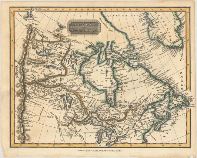
Auction 185, Lot 124
Subject: Canada & Northern United States
[Lot of 3] British Colonies in North America [and] British Colonies, in North America; from the Best Authorities [and] British Colonies, in North America from the Best Authorities, 1797-1815
Size: See Description
Estimate: $240 - $300
Sold for: $230
Closed on 11/17/2021
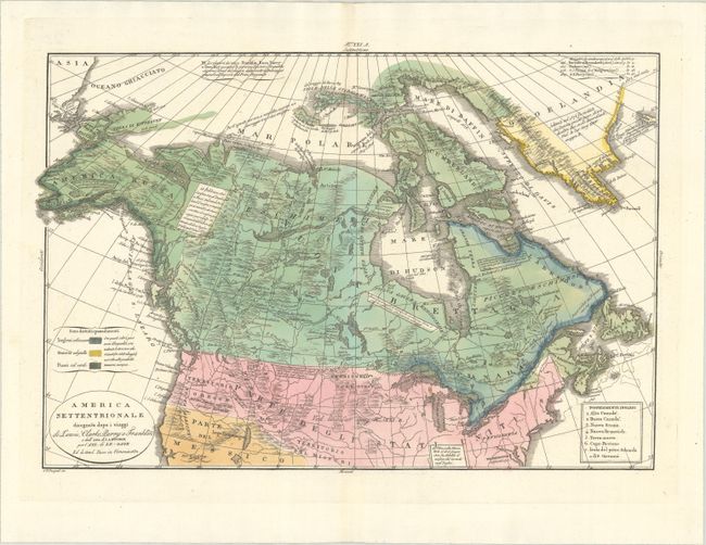
Auction 185, Lot 125
Subject: Canada & Northern United States
Tasso, G.
America Settentrionale Disegnata Dopo i Viaggi di Lewis, Clarke, Parry e Franklin..., 1832
Size: 17.9 x 12.3 inches (45.5 x 31.2 cm)
Estimate: $400 - $475
Sold for: $200
Closed on 11/17/2021
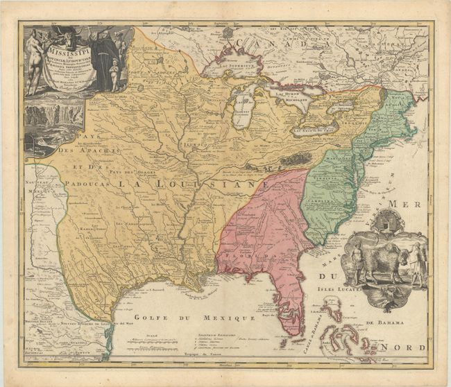
Auction 185, Lot 126
Subject: Colonial Eastern United States & Canada
Homann, Johann Baptist
Amplissimae Regionis Mississipi seu Provinciae Ludovicianae a R.P. Ludovico Hennepin Francisc Miss. in America Septentrionali Anno 1687..., 1730
Size: 22.9 x 19.3 inches (58.2 x 49 cm)
Estimate: $2,000 - $2,300
Striking Map of Colonial America with Bison Vignette
Sold for: $1,500
Closed on 11/17/2021
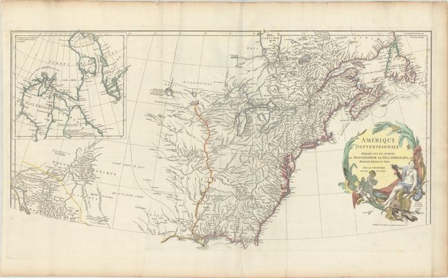
Auction 185, Lot 128
Subject: Colonial Eastern United States & Canada
Anville, Jean Baptiste Bourguignon d'
Amerique Septentrionale Publiee sous les Auspices de Monseigneur le Duc d'Orleans Premier Prince du Sang, 1746
Size: 33.8 x 18 inches (85.9 x 45.7 cm)
Estimate: $600 - $750
Sold for: $450
Closed on 11/17/2021
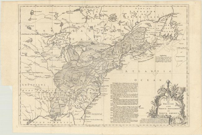
Auction 185, Lot 130
Subject: Colonial Eastern United States & Canada
Lodge, John
A Map of the British and French Settlements in North America, 1755
Size: 15.3 x 11 inches (38.9 x 27.9 cm)
Estimate: $500 - $650
Sold for: $375
Closed on 11/17/2021
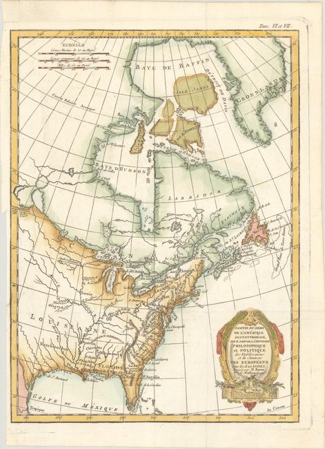
Auction 185, Lot 131
Subject: Colonial Eastern United States & Canada
Bonne/Raynal
Partie du Nord de l'Amerique Septentrionale, pour Servir a l'Histoire Philosophique et Politique des Etablissemens et du Commerce des Europeens dans les Deux Indes, 1774
Size: 9.4 x 12.7 inches (23.9 x 32.3 cm)
Estimate: $200 - $230
Sold for: $150
Closed on 11/17/2021
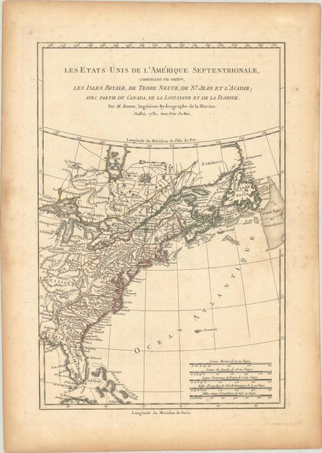
Auction 185, Lot 132
Subject: Colonial Eastern United States & Canada
Bonne, Rigobert
Les Etats Unis de l'Amerique Septentrionale, Contenant en Outre, les Isles Royale, de Terre Neuve, de St. Jean et l'Acadie; avec Partie du Canada, de la Louisiane et de la Floride, 1781
Size: 8.4 x 12.6 inches (21.3 x 32 cm)
Estimate: $160 - $190
Sold for: $95
Closed on 11/17/2021
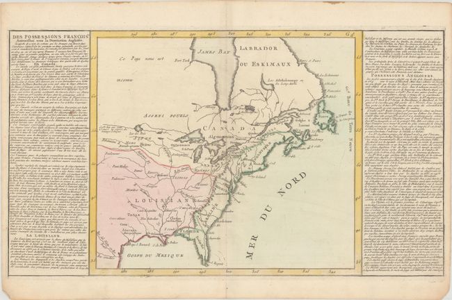
Auction 185, Lot 133
Subject: Eastern United States & Canada
[Lot of 2] Des Possessions Francoises Aujourd'hui sous la Domination Angloises... [and] Etats-Unis de l'Amerique Seple. avec le Canada et la Floride, 1780-90
Size: See Description
Estimate: $275 - $350
Sold for: $325
Closed on 11/17/2021
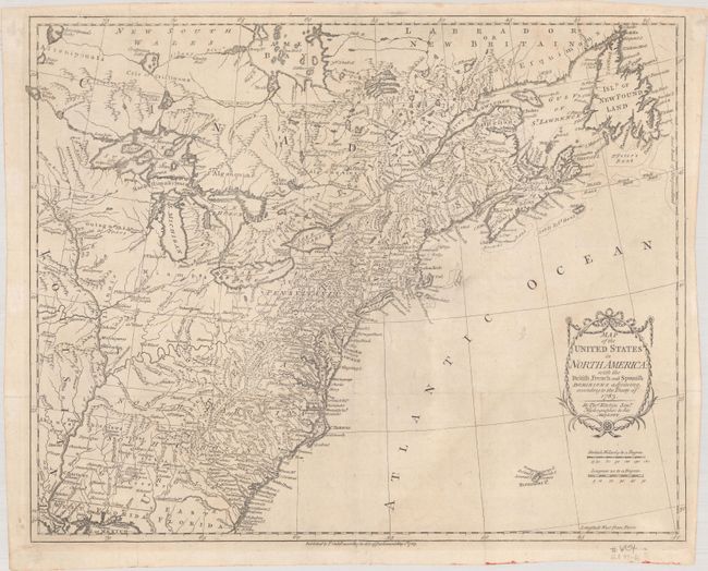
Auction 185, Lot 134
Subject: Eastern United States & Canada
Kitchin, Thomas
Map of the United States in North America: with the British, French and Spanish Dominions Adjoining, According to the Treaty of 1783, 1783
Size: 20.3 x 16.2 inches (51.6 x 41.1 cm)
Estimate: $1,100 - $1,400
One of the Earliest English-Produced Maps to Acknowledge the United States
Sold for: $800
Closed on 11/17/2021
Auction 185, Lot 135
Subject: Eastern United States & Canada
Le Rouge, George Louis
Carte d'une Partie de l'Amerique Septentrionale, pour Servir a l'Histoire de la Derniere Guerre, 1787
Size: 19.4 x 24.1 inches (49.3 x 61.2 cm)
Estimate: $1,000 - $1,300
Sold for: $500
Closed on 11/17/2021
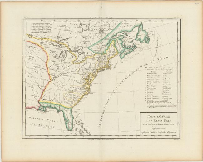
Auction 185, Lot 136
Subject: Eastern United States & Canada
Tardieu, Pierre Francois
Carte Generale des Etats Unis de l'Amerique Septentrionale, Renfermant Aussi Quelques Provinces Angloises Adjacentes, 1797
Size: 16.9 x 12.8 inches (42.9 x 32.5 cm)
Estimate: $240 - $300
Sold for: $120
Closed on 11/17/2021
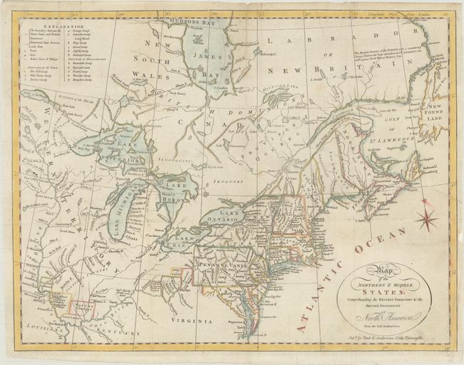
Auction 185, Lot 137
Subject: Northeastern United States & Canada
Doolittle, Amos
Map of the Northern & Middle States: Comprehending the Western Territory & the British Dominions in North America from the Best Authorities, 1800
Size: 15.1 x 11.6 inches (38.4 x 29.5 cm)
Estimate: $325 - $400
Sold for: $230
Closed on 11/17/2021
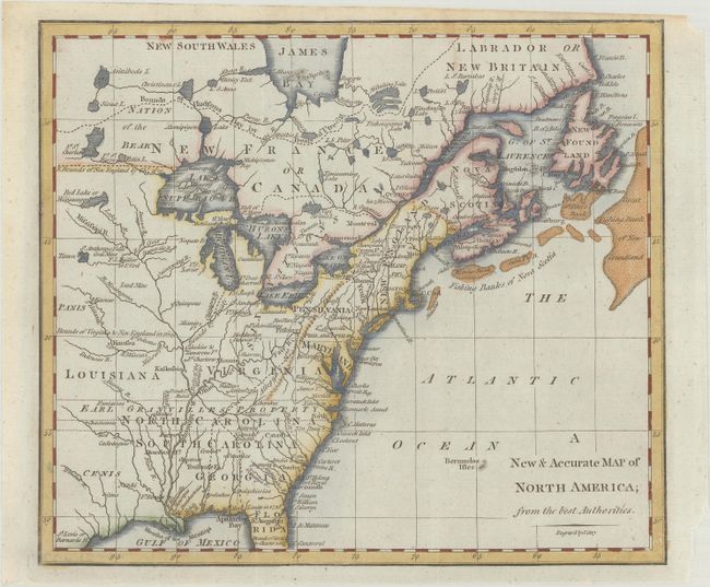
Auction 185, Lot 138
Subject: Eastern United States & Canada
Cary, John
A New & Accurate Map of North America; from the Best Authorities, 1801
Size: 8.8 x 7.6 inches (22.4 x 19.3 cm)
Estimate: $160 - $190
Sold for: $275
Closed on 11/17/2021
Auction 185, Lot 139
Subject: Eastern United States & Canada, Franklin
Rochefoucald Liancourt, Francois Alexander
America, 1805
Size: 12.9 x 15.9 inches (32.8 x 40.4 cm)
Estimate: $1,000 - $1,300
Sold for: $950
Closed on 11/17/2021
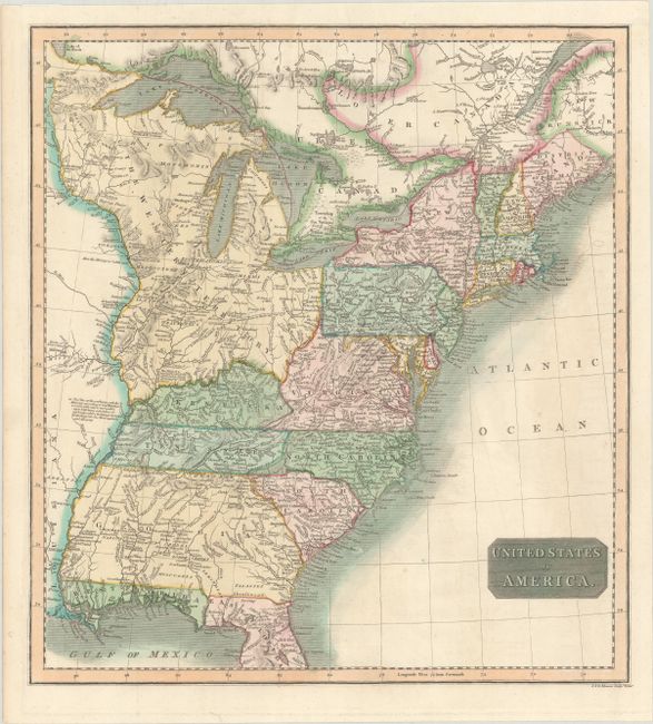
Auction 185, Lot 140
Subject: Eastern United States & Canada
Thomson, John
United States of America, 1815
Size: 14.8 x 16.1 inches (37.6 x 40.9 cm)
Estimate: $190 - $220
Sold for: $240
Closed on 11/17/2021
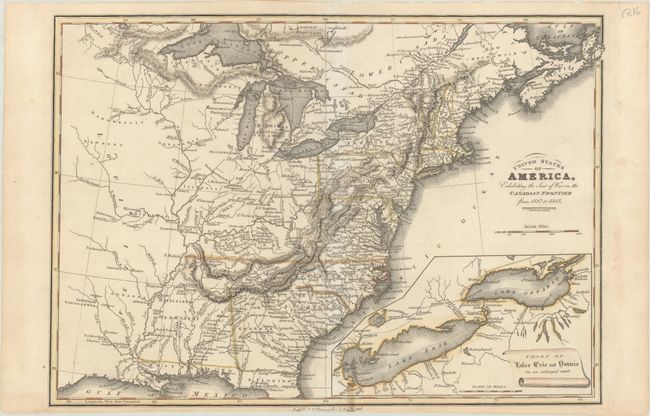
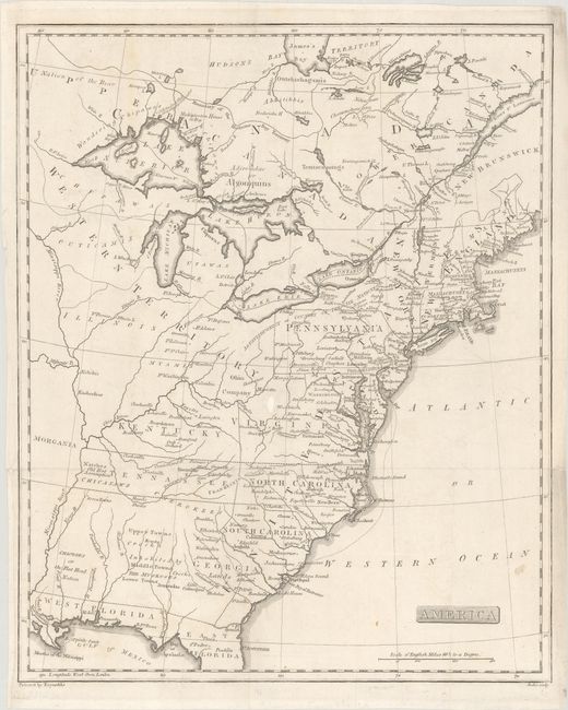
Auction 185, Lot 141
Subject: Eastern United States & Canada
Baines, Edward
United States of America, Exhibiting the Seat of War on the Canadian Frontier from 1812 to 1815, 1816
Size: 13.5 x 9.6 inches (34.3 x 24.4 cm)
Estimate: $300 - $375
Sold for: $160
Closed on 11/17/2021
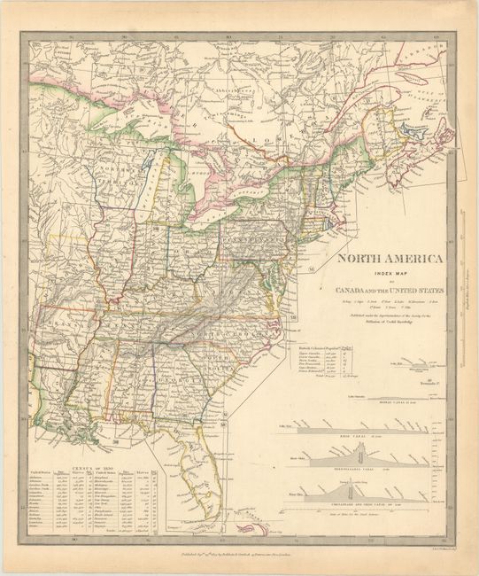
Auction 185, Lot 142
Subject: Eastern United States & Canada
SDUK Society for the Diffusion of Useful Knowledge
North America Index Map to Canada and the United States, 1834
Size: 12.7 x 14.5 inches (32.3 x 36.8 cm)
Estimate: $50 - $70
NO RESERVE
Sold for: $75
Closed on 11/17/2021
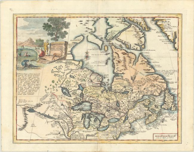
Auction 185, Lot 144
Subject: Colonial Northeastern United States & Canada, Great Lakes
Albrizzi, Girolamo
Carta Geografica del Canada nell' America Settentrionale, 1750
Size: 16.9 x 13.1 inches (42.9 x 33.3 cm)
Estimate: $750 - $900
Sold for: $650
Closed on 11/17/2021
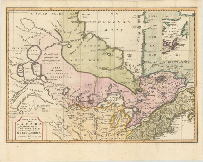
Auction 185, Lot 145
Subject: Colonial Northeastern United States & Canada
Tirion, Isaac
Nieuwe Kaart van Kanada, de Landen aan de Hudsons-Baay en de Noordwestelyke Deelen van Noord-Amerika, 1769
Size: 17.3 x 12.3 inches (43.9 x 31.2 cm)
Estimate: $200 - $230
Sold for: $200
Closed on 11/17/2021
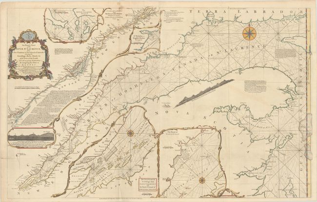
Auction 185, Lot 146
Subject: Colonial Northeastern United States & Canada
Jefferys/Sayer
An Exact Chart of the River St. Laurence, from Fort Frontenac to the Island of Anticosti Shewing the Soundings, Rocks, Shoals &c. with Views of the Lands..., 1775
Size: 37.4 x 23.7 inches (95 x 60.2 cm)
Estimate: $500 - $600
Sold for: $500
Closed on 11/17/2021
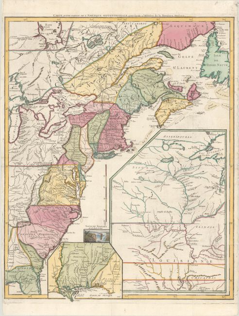
Auction 185, Lot 147
Subject: Northeastern United States & Canada, Great Lakes
Robert de Vaugondy, Didier
Partie de l'Amerique Septent? qui Comprend la Nouvelle France ou le Canada, 1799
Size: 23.6 x 18.9 inches (59.9 x 48 cm)
Estimate: $475 - $600
Sold for: $350
Closed on 11/17/2021
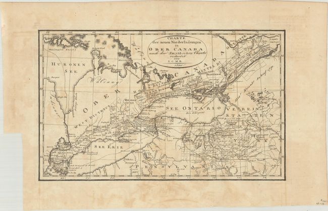
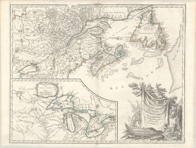
Auction 185, Lot 148
Subject: Northeastern United States & Canada, Great Lakes
I.C.M.R.
Charte der Neuen Niederlassungen in Ober Canada nach der Smythschen Charte, 1800
Size: 12.4 x 7.6 inches (31.5 x 19.3 cm)
Estimate: $140 - $170
Sold for: $220
Closed on 11/17/2021
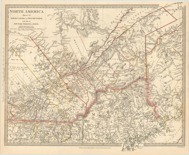
Auction 185, Lot 149
Subject: Northeastern United States & Canada
[Lot of 2] North America Sheet II Lower-Canada and New Brunswick with Part of New-York, Vermont and Maine [and] Lower Canada, New Brunswick, Nova Scotia &c., 1832-60
Size: See Description
Estimate: $80 - $100
NO RESERVE
Sold for: $120
Closed on 11/17/2021
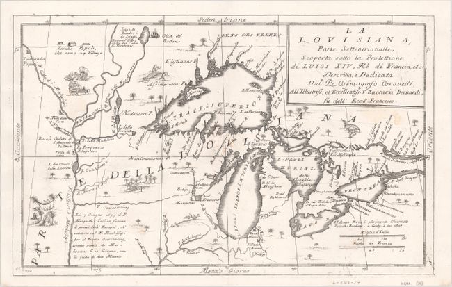
Auction 185, Lot 150
Subject: Colonial Central United States & Canada, Great Lakes
Coronelli, Vincenzo Maria
La Louisiana, Parte Settentrionalle, Scoperta Sotto la Protettione di Luigi XIV, Re di Francia, Etc. , 1696
Size: 16.4 x 10.1 inches (41.7 x 25.7 cm)
Estimate: $2,750 - $3,500
Coronelli's Important Map of the Great Lakes & Upper Mississippi River Valley
Sold for: $4,500
Closed on 11/17/2021
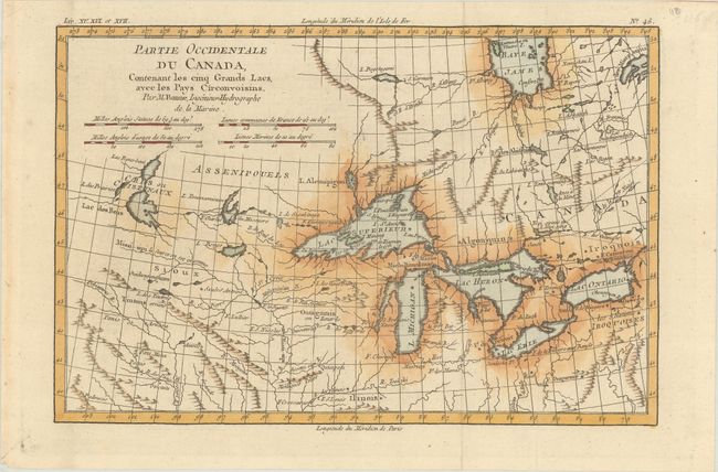
Auction 185, Lot 151
Subject: Colonial Central United States & Canada, Great Lakes
Bonne, Rigobert
Partie Occidentale du Canada, Contenant les Cinq Grands Lacs, avec les Pays Circonvoisins, 1780
Size: 12.5 x 8.3 inches (31.8 x 21.1 cm)
Estimate: $220 - $250
Sold for: $110
Closed on 11/17/2021
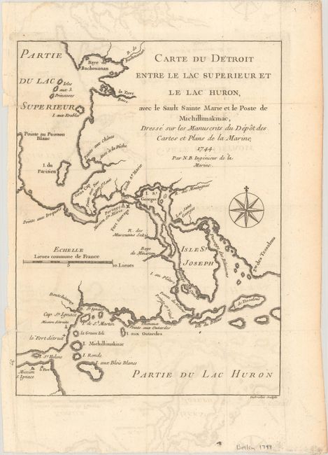
Auction 185, Lot 152
Subject: Colonial Great Lakes
Bellin, Jacques Nicolas
Carte du Detroit Entre le Lac Superieur et le Lac Huron, avec le Sault Sainte Marie et le Poste de Michillimakinac..., 1744
Size: 6.3 x 8.4 inches (16 x 21.3 cm)
Estimate: $200 - $230
Sold for: $300
Closed on 11/17/2021
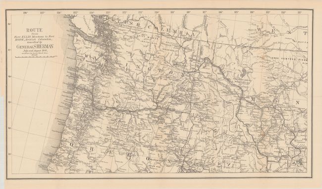
Auction 185, Lot 153
Subject: Northwestern United States & British Columbia
U.S. Government
[Map with Report] Route from Fort Ellis Montana to Fort Hope, British Columbia, Travelled by General Sherman July and August 1884, as Shown by Heavy Black Line, 1883
Size: 27.4 x 15.2 inches (69.6 x 38.6 cm)
Estimate: $250 - $325
Sold for: $150
Closed on 11/17/2021
36 lots