Catalog Archive
Auction 185, Lot 153

"[Map with Report] Route from Fort Ellis Montana to Fort Hope, British Columbia, Travelled by General Sherman July and August 1884, as Shown by Heavy Black Line", U.S. Government

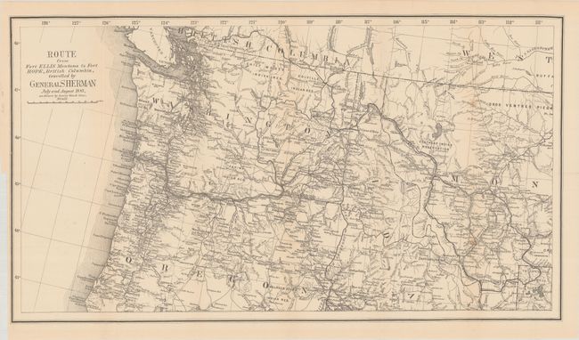
Subject: Northwestern United States & British Columbia

Period: 1883 (dated)

Publication:

Color: Black & White

Size:
27.4 x 15.2 inches
69.6 x 38.6 cm
Download High Resolution Image
(or just click on image to launch the Zoom viewer)

A heavy dark line depicts General Sherman's route from Yellowstone to Fort Hope, B.C. Sherman led his troops through the sites of many native battles in his final year as the Head of the Army, retiring in November of 1883. The map has fine detail of watersheds in the Northwest. It extends as far east as Bozeman to show most of Yellowstone National Park, and south to show Point Orford in Oregon. Roads, Indian reserves, towns, rivers and the rail lines are noted. The map is accompanied by the 50-page disbound report by John C. Tidball describing Sherman's journey.

References:

Condition: B+

Issued folding with a hint of toning and a couple of spots along a vertical fold at right. Disbound text is lightly toned.

Estimate: $250 - $325

Sold for: $150

Closed on 11/17/2021

Archived