The Mapmakers Who Made the 18th Centuryby Joe McAlhany
Our series on notable mapmakers throughout the centuries continues with a look at four of the major cartographers and publishers of the 18th century: Guillaume Delisle, Johann Baptist Homann, Thomas Jefferys, and Herman Moll. (You can click here to learn more about mapmakers of the 16th century and click here to read about mapmakers of the 17th century.) During the 17th century, the Dutch dominated the field of cartography with their ornate style, but by the early 18th century, the epicenter of European mapmaking had shifted to Paris. French cartographers embraced the Enlightenment concept of “positive geography” and developed a more scientific approach to cartography. But as the century progressed and the power and influence of the British Empire expanded, the map publishing business in London boomed. Meanwhile, German publishers produced beautiful maps that continued the decorative legacy of the Golden Age of Dutch cartography without sacrificing the level of detail and information valued in a more scientific era.
Guillaume Delisle (1675-1726)
If Nicolas Sanson is the “father” of French cartography, then Guillaume Delisle (or de l’Isle) could be considered the “son,” the representative of the next generation of French cartographers. According to Carl Moreland and David Bannister, he was recognized as “‘the first scientific cartographer’ and the foremost geographer of his age.” Along with his contemporaries, he ushered in a new era of increased accuracy and integrity in mapping.
Guillaume Delisle was born in Paris on February 28, 1675, to Marie Malaine and Claude Delisle, a geographer and historian who studied under Sanson. A precocious child, Guillaume supposedly drew his first map at age 9. He was a pupil of Jean Dominique Cassini (1625-1712), an Italian astronomer appointed to the Paris Observatory by Louis XIV. Cassini introduced astronomical methods for measuring longitude and developed a method of triangulation with mathematician Jean Picard. These innovations paved the way for Delisle’s own rigorous geography.
In 1700, Delisle and his father were locked in an extended public plagiarism dispute against Jean-Baptiste Nolin, who had copied geographical discoveries that the Delisles claimed were original to their world map. Eventually a jury of experts (among them Cassini) ruled in favor of the Delisles. According to Mary Sponberg Pedley, “One result of this suit was to establish the young Delisle’s authority as a mapmaker through his command of a map’s sources.”
Delisle was elected to the Académie Royale des Sciences in 1702. This appointment granted him access to the most up-to-date information on discoveries in the New World and advancements in astronomy and geography. He published groundbreaking maps of North America that featured more accurate versions of the course of the Mississippi River, peninsular California, the Great Lakes, and Canada. Throughout his career, he carefully studied firsthand accounts and other cartographic sources and updated his maps as new information flooded in. His reputation as a master geographer led to his appointment as the Dauphin’s tutor and Premier Géographe du Roi in 1718.
On January 25, 1726, Delisle died in Paris. Although two of his brothers, Joseph Nicolas and Louis, were also cartographers, Delisle’s widow Marie Angélique carried on his business, selling his maps until her own death in 1745. She was succeeded by her son-in-law Philippe Buache. In 1780, Jean Claude Dezauche purchased the Delisle and Buache stock.
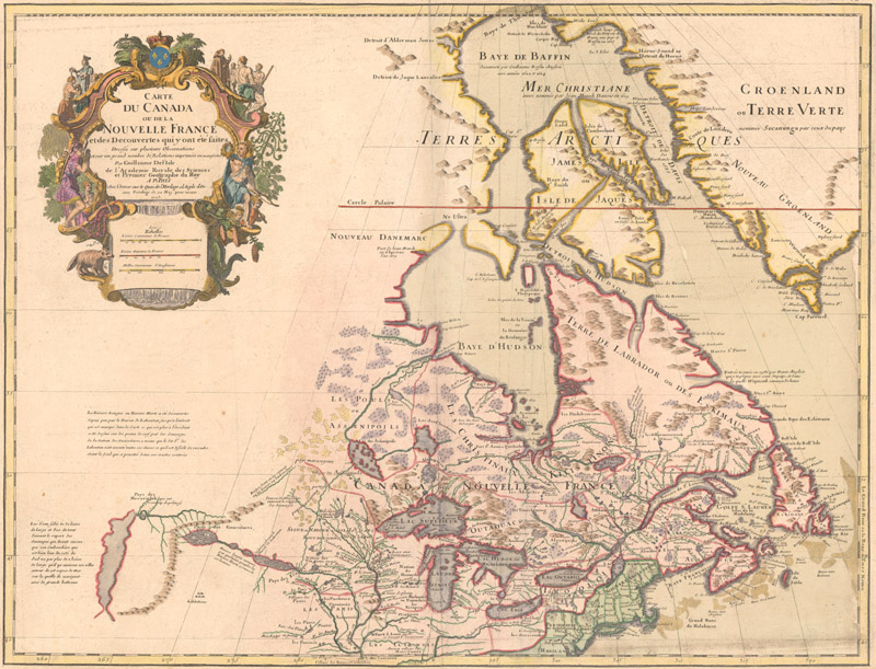
Carte du Canada ou de la Nouvelle France et des Decouvertes qui y ont ete faites… (1703)
Delisle's map of Canada and the Great Lakes is one of the most outstanding and influential maps of the century. For the first time, the Great Lakes are portrayed correctly, and Detroit marks its debut on this map, only two years after its founding. Delisle's meticulous cartography incorporates new information from Louis Jolliet, Jean-Baptiste-Louis Franquelin, and the Jesuit explorers. It correctly positions the Ohio River but confuses its name with the Wabash River. West of the Mississippi, Lahontan's fictitious Riviere Longue is prominently traced. In Canada, special attention is given to the rivers and lakes between Hudson Bay and the St. Lawrence, and Lac de Assenipoils (Lake Winnipeg) connects to Hudson Bay. Sanson's three islands of the Arctic are retained. The exquisite cartouche, engraved by Guerard, features a beaver, natives (one of whom is bearing a scalp), a priest, and friars. Pictured above is the fifth state of the map, published circa 1718, with Delisle’s imprint amended to reflect his new position as Premier Géographe du Roi.
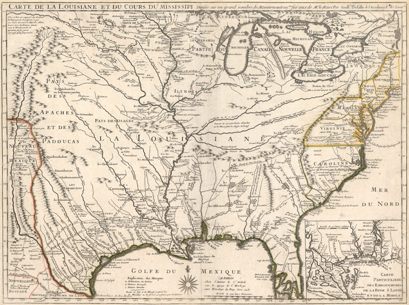
Carte de la Louisiane et du Cours du Mississipi… (1718)
During an expedition down the Mississippi River in 1682, René-Robert Cavelier, Sieur de La Salle named the Mississippi Basin La Louisiane after Louis XIV and claimed the area for France. This map by Delisle became the foundation map for the massive new French colony. It draws on the cartographic work of the previous half century and had a tremendous impact on the history of cartography. For the remainder of the century, numerous European cartographers copied the map for their depictions of the region.
The map was designed for the political purpose of invalidating the English claims west of the Appalachian Mountains and laid claim to Carolina by the French, which provoked an angry English response. Delisle renders the French claims with the Rio Grande serving as the boundary line between Louisiana and Mexico, a position which was contested between the French, Spanish, and British and spawned a “cartographic war.”
However, the map is most notable today for its delineation of the Mississippi valley. It was the first detailed map of the Gulf region and the Mississippi, and the first to show the explorations of Hernando de Soto, Alphonse de Tonty, Luis de Moscoso Alvarado, and Louis Juchereau de St. Denis. Delisle based the cartography on the memoir and manuscript maps of French missionary Francois le Maire. The map is also notable for featuring the first printed appearance of the name “Texas” on a map, noting the legendary Mission de los Teijas.
Herman Moll (ca. 1654-1732)
In the early decades of the 18th century, there was no mapmaker and engraver in Britain more prolific than Herman Moll. Over the course of more than five decades, he produced countless cartographic works: maps, charts, globes, atlases, and geographies. His engraving style is one of the most instantly recognizable in the history of cartography—there is no mistaking a Moll map for anybody else’s work. His personality and worldview were often explicitly on display in his maps, with extensive notes of text championing the British Empire or expressing contempt for other mapmakers (“ignorant Pretenders”).
Information about his early life is sparse; until 1978, it was widely believed that he was Dutch. He was born circa 1654 in Germany, possibly in Bremen. In 1678, he emigrated from Germany and went to work as an engraver for Moses Pitt. Soon he joined one of London's most interesting social circles, which gathered at Jonathan's Coffee House, and included stock speculators, scientists, archaeologists, authors, pirates, and sea-captains. From these friends, Moll gained a great deal of privileged information that he compiled into his cartographic works.
After a partnership with Philip Lea as a publisher and map-seller dissolved in 1691, Moll spent the next 17 years working primarily as an engraver. There was plenty of work for him. As public interest in the expeditions of English mariners such as William Dampier and William Hacke increased, publishers sought to meet the demand with accounts of their travels—and what better way to illustrate these tales of globetrotting than with maps. Moll contributed maps to many publications, including Thesaurus Geographicus (1695), Dampier’s New Voyage Round the World (1697), A System of Geography (1701), and John Harris’ Navigantium (1705). As Ashley Baynton-Williams states in his excellent biography of Moll in the first issue of MapForum, “The list of books published from 1695 to 1708 containing a map or maps by Moll is a long one, with perhaps as many as half the books containing a single map published in this time frame having that map engraved by Moll.”
Starting in 1707, Moll embarked on what would become his best known work: the large decorative maps produced for The World Described. Originally published separately, this series of two-sheet maps was compiled into a complete elephant folio atlas in 1717. Among the maps of note in the atlas are Moll’s world map and his famous Beaver and Codfish maps of North America. The maps from this atlas continued to be popular in the decades following Moll’s death, undoubtedly shaping how the British saw the world.
Moll continued his smaller scale work as well. In 1711, he founded Atlas Geographus, a quarto geography released in monthly installments that ran until 1717. His Atlas Minor (first published in 1729), a quarto atlas of 62 maps, was a late success, with new editions published until the 1760s. After Moll’s death on September 22, 1732, Thomas and John Bowles took possession of his stock and continued publishing his maps and atlases. Due to his popularity and the sheer volume of his work, Moll’s maps continued to dominate the British market for decades.
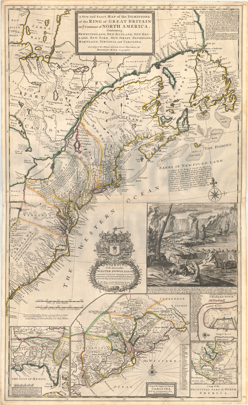
A New and Exact Map of the Dominions of the King of Great Britain on ye Continent of North America... (1715)
First published in 1715 as part of The World Described, Moll’s famous “Beaver Map” is widely considered to be one of the earliest and most important maps to depict the emerging boundary dispute between the French and British colonies in North America. It refutes the French claims to the Carolinas from Delisle’s Louisiana map (discussed in the preceding section) and shows the region from Newfoundland south to the mouth of the St. John's River (Florida) under British Control. In addition, the inset A Map of the Principal Part of North America extends British claims further north with New Britain occupying Labrador and the area surrounding Hudson's Bay.
The map thoroughly reflects the contemporary British view of North America. It is sometimes referred to as the first American postal map as it traces several early postal routes. In the interior, numerous forts, Indian tribes, mountains, and watersheds are identified along with copious notations. Along the Appalachians, Moll claims that the Iroquois "are all hearty friends to ye English." The lower third of the map contains four insets: a large and detailed map of the Carolinas; a map of the present-day southern United States based upon Indian Agent Thomas Nairne; a map of eastern North America showing colonial interests; and a plan of Charleston.
The map’s nickname is derived from its striking inset scene of beavers constructing a dam at Niagara Falls, based in large part on a view from Nicholas de Fer's large wall map entitled Carte de la Mer du Sud & de la Mer du Nord. Beavers were an apt symbol for America given the animal’s critical importance in the fur trade as well as its industrious nature. Moll describes the beaver's process as they "lay ye foundation of ye Dam; they make Mortar, work up, and finish ye whole with great order and wonderfull Dexterity."
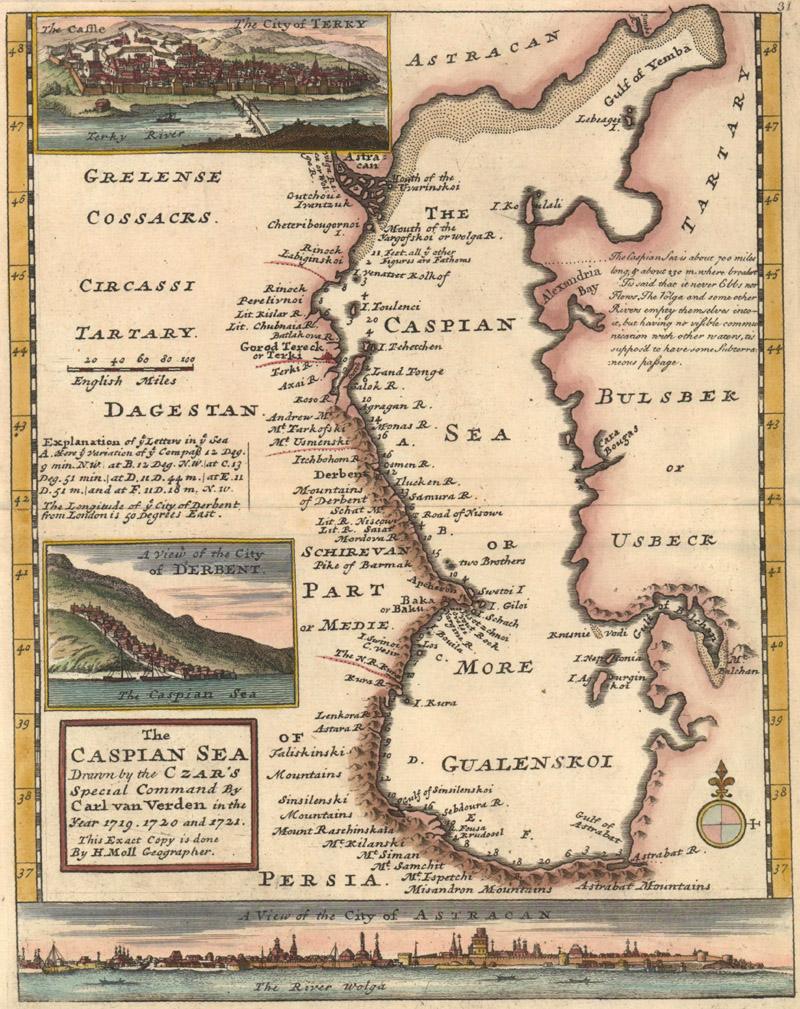
The Caspian Sea Drawn by the Czar's Special Command by Carl van Verden in the Year 1719. 1720 and 1721 (ca. 1729)
Although this small map of the Caspian Sea is far from one of Moll’s most important, it is nonetheless a fine example of the craftsmanship he continued to bring to his projects even in his later years. First published in his Atlas Minor in 1729, it is surprisingly detailed for its size, showing a western coastline with numerous place names as well as depth soundings. A lettered key at left details the variations of the compass at several locations within the Caspian Sea, and a note at right explains that the sea never ebbs or flows and that there are likely subterranean passages between the sea and other rivers. The composition is complete with three inset city views of Derbent, Astrakhan, and Terky, a city along the Terek River.
Johann Baptist Homann (1664-1724)
Johann Baptist Homann was the key German cartographer and map publisher of his era. He was born in Oberkammlach in Swabia, Bavaria, on March 20, 1664. After an education with the Jesuits, he converted to Protestantism and relocated to Nuremberg in 1687, where he found work as a public notary. In 1693, he moved to Vienna, where he studied engraving and printing for a couple years. When he returned to Nuremberg, he began to work as an engraver for cartographers such as Jacob von Sandrart and David Funcke.
In 1702, Homann founded his own publishing firm. It was the beginning of a publishing empire that would continue for the next century and a half. The firm began to compile atlases starting in 1707, culminating in Homann’s masterwork, Grosser Atlas uber die Ganze Welt, a collection of more than 100 maps that was first published in 1716. Homann’s maps were distinguished by their distinctive lettering, attention to political divisions, and large, ornate cartouches featuring allegorical figures and local detail. His city plans are especially impressive, with sprawling, intricately detailed panoramic views extending across the bottom.
Homann was appointed Imperial Geographer by the Holy Roman Emperor Charles VI and was named a member of the Prussian Royal Academy of Sciences in Berlin in 1715. These positions earned him access to the latest cartographic information and an imperial printing privilege, a proto-copyright that protected his work from being copied by other publishers. But even though direct copying was forbidden, Homann’s maps shaped German cartography for a century. The maps of Matthäus Seutter (a former Homann apprentice) and Tobias Conrad Lotter, the other major German publishers of the era, are heavily indebted to the Homann style.
After Homann’s death in July 1724, his son Johann Christoph took over the company, running it until his own death in 1730. The firm continued from that point under the name Homann Heirs until circa 1852, when manager Christoph Melchior Fembo finally shuttered the business.
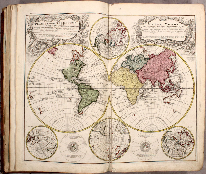
Grosser Atlas uber die Gantze Welt... (1716)
First published in 1716, Homann’s landmark atlas solidified his reputation as the great German mapmaker of his era. The atlas featured maps of the world and continent, but much of the work consists of stunningly detailed regional maps of Europe; the example above (published circa 1751) includes 100 maps spanning the entire continent. Numerous subsequent editions were issued, including updated posthumous editions published by the Homann Heirs.
The map pictured above is the atlas’s double-hemisphere world map drawn by Georg Moritz Lowitz and based on the work of Johann Mathias Haas. It includes four polar spheres, each in a different projection, and two interesting diagrams depicting the earth as it would be seen from space. North America is still blank above California and Hudson Bay is open-ended in the northwest corner. The large, mythical Xarayes Lake appears in the center of South America. In the South Pacific, there are partial coastlines of New Zealand, Australia and Tasmania.
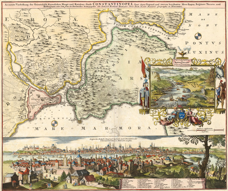
Accurate Vorstellung der Orientalisch-Kayserlichen Haupt- und Residenz-Stadt Constantinopel… (ca. 1720)
This map is one of the most decorative maps of the strategic region between the Mediterranean and Black seas and a fine example of Homann’s classic city views. The lower third of the sheet is a finely rendered bird's-eye panorama of Constantinople viewed from the north. A legend identifies the Seraglio, Hagia Sophia, the Galata Tower, several mosques, and many other locations of note. It portrays the entrance to the Golden Horn before any bridges were built. At right there is a large inset bird's-eye view of the Dardanelles with several ships engaged in battle in the Sea of Marmara. The inset is framed by coats-of-arms, flags, shields, and figures representing civilized Europe on the left and barbaric Asia on the right.
Thomas Jefferys (ca. 1719-1771)
The London-based engraver, geographer, and publisher Thomas Jefferys is best known for the maps of North American and the Caribbean that he published in the lead-up to the Seven Years’ War and his later English county maps based on original surveys. Little is known about his early life, but it is generally believed that he was born around Birmingham in 1719. His professional life began in 1735, when he started an apprenticeship with Emanuel Bowen. During this time, he also met the engraver and mapmaker Thomas Kitchin, another apprentice at Bowen’s shop, and Bradock Mead, better known as John Green, a passionate Irish cartographer with an outlaw lifestyle who collaborated with Jefferys on some of his most important works.
Jefferys struck out on his own in 1744 and received his first royal appointment as the geographer to Frederick, Prince of Wales, a couple years later. He began publishing plans of manufacturing towns in the Midlands, a precursor to his later surveys of England. In 1750, he set up shop at Charing Cross, where he would remain for the rest of his life. There he started to produce milestone maps of the Americas, among them the Fry-Jefferson survey of Virginia (engraved and published by Jefferys in 1753); John Green’s six-sheet chart of the Americas (also 1753); and Captain James Cook’s twelve-sheet chart of the St. Lawrence River (1760). Robert Sayer compiled much of Jefferys’ work from this period and published an atlas, A General Topography of North America, in 1768.
In 1760, Jefferys succeeded his old master Bowen as the Geographer to the King. As his career took off and the Seven Years’ War came to a close, Jefferys turned his attention back to his native country. He embarked on an ambitious project to create comprehensive new maps of various English counties. Unfortunately, commissioning new field surveys was extremely costly, leading him to declare bankruptcy in 1766. Thanks to the help of Sayer and some “compassionate” friends, Jefferys was able to continue work on his county maps—but only after he sold off much of his stock at auction.
The final five years of Jefferys life were very fruitful; along with his collaborators, he produced multi-sheet maps of Bedfordshire, Oxfordshire, Yorskhire, and several other counties. But this final burst of work did little to improve his financial situation: Jefferys died on November 20, 1771, with only 20 pounds (and his debts) to his name. His sixteen-year-old son, Thomas, took control of the business along with William Faden, who supplanted Jefferys as Geographer to the King. Sayer also continued to publish Jefferys’ material with partner John Bennett in collections such as The American Atlas, The West India Atlas, and The North-American Pilot (all published in 1775).
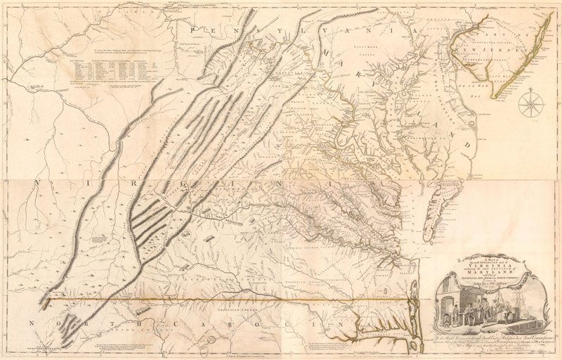
A Map of the Most Inhabited Part of Virginia Containing the Whole Province of Maryland with Part of Pensilvania, New Jersey and North Carolina (1753)
As mentioned above, Jefferys engraved and published the four-sheet map of Colonel Joshua Fry and Peter Jefferson’s landmark survey of colonial Virginia and Maryland, beginning with the first edition in 1753. Fry and Jefferson, then surveyor and deputy surveyor for Albemarle County respectively, were tasked with drawing the first updated map of Virginia since Augustine Hermann’s map of 1673. They were ideal appointees for the project as they had accumulated a substantial amount of information from their work on the backcountry, the Northern Neck controversy, and the westward extension of the border between Virginia and North Carolina. Their knowledge, along with reports received from their acquaintances who had explored the western territories, produced the most detailed account of the inhabited parts of the colony. A major revision in 1755 incorporated new information about the western frontier from information collected by Fry, George Washington, and the journals of John Dalrymple and Christopher Gist.
Cartographically, the map was the first to correctly orient the ridges of the Appalachian Mountains and the western flow of the New, Greenbrier, and Monongahela Rivers. The map also depicts the "Great Waggon Road" that begins in Philadelphia and heads south through the Shenandoah Valley and into North Carolina. Both of these important features would serve as paths toward future population flow and development. Numerous early plantations are located including landowners' names. To the east the map shows the road from Williamsburg to Edenton, North Carolina and details the flow of rivers into Albemarle Sound.
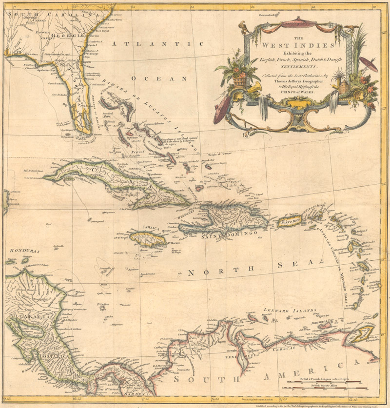
The West Indies Exhibiting the English, French, Spanish, Dutch & Danish Settlements (1760)
Some of Jefferys’ most important contributions to the history of cartography were his maps focused on the West Indies, including the 16-sheet chart of the region that formed the heart of his posthumously published West-India Atlas (1775). This uncommon map of the Caribbean comes from The Natural and Civil History of the French Dominions in North and South America, a monumental earlier work describing Canada, Louisiana, and the French possessions in the West Indies. The chart shows the colonial holdings of Britain, France, Spain, the Netherlands, and Denmark during the Seven Years’ War, providing critical context for Jefferys’ British audience. Southern Florida is shown with large, interconnected waterways effectively turning the region into an archipelago. The boundary between Florida and Georgia is labeled Limits Stipulated in 1738.
The World Takes Shape
Delisle, Moll, Homann, and Jefferys were at the cutting edge of 18th-century cartography, helping to shape and define a world rapidly coming into focus. Over the course of the century, exploration and colonization expanded the scope of the known world, especially in the Pacific and the Americas. Advances in geography enabled cartographers to map these new discoveries with increasing accuracy. The days of conjecture and myth in cartography were fast coming to an end. Our next newsletter will take us into the 19th century, specifically focusing on the emerging American mapmakers.
References:
Baynton-William, Ashley, “The World Described,” MapForum Issue 1, London, Spring 2004.
French, Josephine (ed.), Tooley’s Dictionary of Mapmakers – Revised Edition, Map Collector Publications Limited/Early World Press, England, 1999-2004.
Manasek, F.J., Curt Griggs & Marti Griggs. Collecting Old Maps, Old Maps Press, Clarkdale, Arizona, 2015.
Moreland, Carl & David Bannister, Christie's Collectors Guides Antique Maps, Phaidon, Oxford, 1986.
Pedley, Mary Sponberg, The Commerce of Cartography: Making and Marketing Maps in Eighteenth Century France and England, University of Chicago Press, 2005.
Worms, Laurence, “Beginning the World Afresh,” MapForum Issue 3, London, Autumn 2004.
STILL MORE Free Online Content for Cartophilesby Eliane & Jon Dotson
We are still compiling a list some of the free online resources that are now available to satiate your need for cartographic content while you remain confined. In case you missed it, we are repeating the list below, along with a few new items you may find interesting:
NEW! Waldseemüller’s Carta Marina. Chet van Duzer's 8 May 2020 talk at Stanford's Rumsey Center on "Portraying the World Anew: Martin Waldseemüller’s Carta Marina" is available here on YouTube.
NEW! Ortelius’ Theatrum Orbis Terrarum. Jim Akerman of the Newberry Library in Chicago has created an online presentation featuring Ortelius' famous atlas that can be viewed here.
History of Cartography Project. Several volumes of the monumental History of Cartography project are available for free online. Click here.
Library of Congress Story Maps. Story Maps are "immersive web applications that tell the incredible stories of the Library’s collections through narrative, multimedia, and interactive maps." Click here for all of the LOC's Story Maps or click here for "Maps that Changed our World."
Article on Mapping Public Health. The Washington Map Society has just released a member's-only article that appeared in the Spring 2018 issue of The Portolan. Click here for a high-resolution version of Lauren Bouchard Killingsworth’s prize-winning article on “Mapping Public Health in Nineteenth-Century Oxford,” or click here for a low-resolution version.
How Maps Are Made. This lecture by Chris Lane of the Philadelphia Print Shop West was previously given at the Miami Map Fair and is available on YouTube by clicking here. Chris intends to add more lectures to his YouTube channel soon.
Library of Congress Maps Blog. Both the collections and the staff of the Geography & Map Division of the Library of Congress are incredible resources, and there is a blog dedicated to highlighting some of the maps in their collection. To view the blog click here.
The Bodleian's Map Room Blog. Not to be outdone, the Bodleian Library at the University of Oxford also has a blog about "items of interest from the wonderful world of maps." To read the blog click here.
PJ Mode Collection of Persuasive Cartography. Housed on the Cornell University Library website, this collection of over 800 thoroughly catalogued maps focuses on "maps intended primarily to influence opinions or beliefs." You can view the maps in high resolution, read about each map's historical significance, and even download the map images to your own computer. Click here to view the collection.
"New Projections" Podcast. Curtis Bird, owner of The Old Map Gallery in Denver, Colorado has a podcast that focuses on map-related topics. You can download it though the Apple podcasts app, the Google podcasts app, or listen to it from your computer by clicking here.
Miniature Maps. This "illustrated guide to miniature antique maps, charts, plans and atlases" was created by Geoffrey L. King and is the definitive resource on this subject. Lose yourself in a tiny world by clicking here.
The Map Room Blog. This blog by Jonathan Crowe "covers everything from antique map collecting to the latest in geospatial technology" and represents curated content drawn from all over the internet. You can search through the archive to find specific topics. Click here for the blog.
OWA Newsletter Archive. This is actually our 54th newsletter, and all of our previous newsletters are available in an archive on our website. We have dozens of articles on mapmakers, cartographic curiosities, collecting tips, and more. Check out our newsletter archive here.