Subject: Caribbean
Period: 1760 (published)
Publication: The Natural and Civil History of the French Dominions in North and South America
Color: Hand Color
Size:
17.7 x 18.4 inches
45 x 46.7 cm
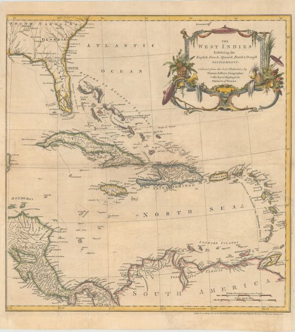
Thomas Jefferys was one of the most important English map publishers of the 18th century. His work included prints and maps of locations around the world, but his most notable maps are of North America and the West Indies. He began his career in the map trade in the early 1730s, working as an engraver for a variety of London publishers, and eventually setting up his own shop. In 1746, he was appointed Geographer to the Prince of Wales, and in 1760 he became Geographer to the King. These titles granted access to manuscripts and cartographic information held by the government. In the early 1760s he embarked on an ambitious project to produce a series of English county maps based on new surveys, but ran out of money and filed for bankruptcy in 1766. He then partnered with London publisher Robert Sayer, who reissued many of Jefferys plates and continued to issue new editions after Jefferys' death in 1771. Jefferys' American Atlas and the accompanying West-India Atlas, published post posthumously, are considered his most important cartographic works.
This is an uncommon map of the Caribbean showing the colonial holdings of Britain, France, Spain, the Netherlands and Denmark during the Seven Years' War. Southern Florida is shown with large, interconnected waterways effectively turning the region into an archipelago. The boundary between Florida and Georgia is labeled Limits Stipulated in 1738. There is good detail of the rivers, mountains, and coastal place names throughout. This map was published in The Natural and Civil History of the French Dominions in North and South America, Jefferys' monumental geographical and historical work describing Canada, Louisiana and the French possessions in the West Indies. This map is rarely offered on the market.
References: Shirley (BL Atlases) G.JEF-1a #9.
Condition: B+
A nice impression, issued folding, now pressed with light offsetting and a few fold separations that have been professionally repaired. There is a binding tear at right that enters 1.5" into image that has also been professionally repaired.