Subject: Colonial Eastern United States & Canada
Period: 1715 (dated)
Publication: The World Described, or a New and Correct Sett of Maps...
Color: Hand Color
Size:
24.1 x 39.9 inches
61.2 x 101.3 cm
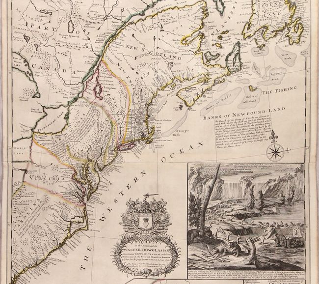
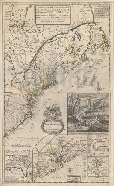
This is Moll's famous "Beaver Map," first published in 1715 and widely considered to be one of the earliest and most important maps to depict the emerging boundary dispute between the French and British colonies in North America. Moll's map refutes the French claims to the Carolinas as seen in Delisle's Carte de la Louisiane et du Cours du Mississipi and shows the region from Newfoundland south to the mouth of the St. John's River (Florida) under British Control. In addition, the inset A Map of the Principal Part of North America extends British claims further north with New Britain occupying Labrador and the area surrounding Hudson's Bay. The map is also notable for showing a number of early postal routes in the colonies and is sometimes referred to as the first American postal map. In the interior, numerous forts, Indian tribes, mountains, and watersheds are identified along with copious notations. Along the Appalachians, Moll notes that the Iroquois "are all hearty friends to ye English." In the Atlantic, Moll notes France's fishing rights in the banks: "The French by the Treaty of Utrecht are allowed to catch Fish, and to dry them on land, in that Part only, and no other, of the Island of Newfound-Land." The lower third of the map contains four insets including a large and detailed map of the Carolinas, a map of the southern United States based upon Indian Agent Thomas Nairne, a map of eastern North America showing colonial interests, and a plan of Charleston. All in all, a very complete picture of the British view of North America at the time.
The map is richly embellished with a dedication cartouche to Walter Douglas, Captain-General and Governor-General of the Leeward Islands, a compass rose with fleur-de-lis, and the striking scene at Niagara Falls, where dozens of beavers construct a dam. The use of the beaver as a symbol for America is apropos as it demonstrates the animal's critical importance in the fur trade as well as its hard-working nature. Moll describes the beaver's process as they "lay ye foundation of ye Dam; they make Mortar, work up, and finish ye whole with great order and wonderfull Dexterity." Moll followed Nicholas de Fer's large wall map entitled Carte de la Mer du Sud & de la Mer du Nord for much of the design on this inset.
This is the third state of the map with imprint "Printed and sol by Tho: Bowles next ye Chapter House in At. Paul's Church-yard, John Bowles at the Black Horse in Cornhill, and by I. King at ye Globe in ye Poultrey near Stocks Market," published circa 1731. Printed on two joined sheets.
References: McCorkle #715.1; Stevens & Tree #55c; Pritchard & Taliaferro #19; Cumming (SE) #158; Schwartz & Ehrenberg, plt. 78; Shirley (BL Atlases) T.MOLL-4c #10.
Condition: A
A beautiful example with dark impression and contemporary outline color. There is some very minor creasing adjacent to St. George's Bank and one tiny hole caused by a paper flaw in the rocky area of the Beaver inset only visible when held to light. Very nearly an A+. The first image was taken with a digital camera to show the true colors of the map. The second image was run through our digital scanner for zooming purposes. The bluish hue near the center of this second image is caused by the scanner and not on the physical map.