The Mapmakers Who Made the 16th Centuryby Joe McAlhany
As every map enthusiast knows, the history of cartography is a vast subject. Scholars and specialists can spend their entire lives exploring one tick mark in the grand timeline of cartographic history and never exhaust their chosen topic. Most of us start out with a more general view, but with all those tick marks from cave drawings to GPS, it can be easy to get overwhelmed. So how should one best approach the rich history of maps and mapmakers?
How about one century at a time? Over the next four newsletters, Old World Auctions will do just that, providing readers with a brief overview of the trends and developments in mapping during the 16th, 17th, 18th, and 19th centuries. We will do this by identifying several key mapmakers from each era and considering their contributions to cartographic history through the lens of their most interesting maps.
We make no claim that this will be a definitive ranking of cartographers and maps (as if such a thing were even possible), or an in-depth dive into an entire century of mapmaking. Our aim is to highlight a sampling of the major figures in the art of mapmaking and to magnify examples of their defining work. These are some of the most significant notches on the timeline of cartographic history, but they are only a part of the story.
This month, we will by taking a closer look at three of the biggest names in 16th-century cartography: Sebastian Münster, Gerard Mercator, and Abraham Ortelius.
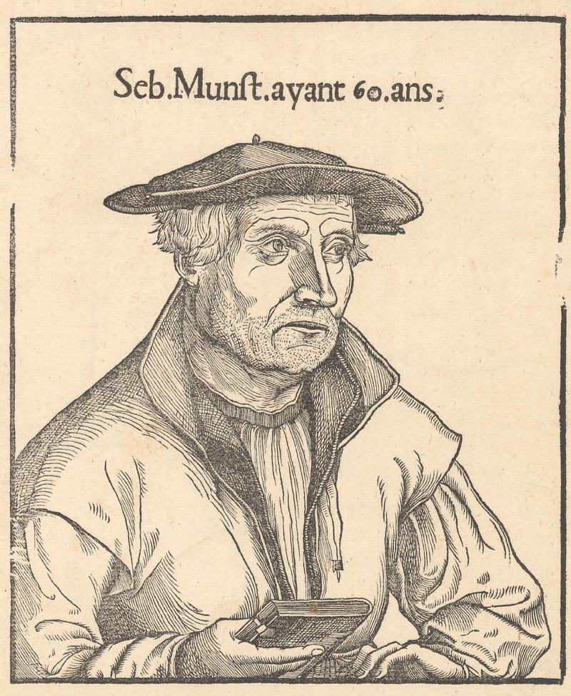
Sebastian Münster (1488-1550)
Sebastian Münster, "Seb. Munst. Ayant 60. Ans.," 1552
Our discussion of the cartography of the 16th century begins with the Hebraist, mathematician, and geographer Sebastian Münster. He is best known for his groundbreaking edition of Ptolemy’s Geographia (first published in 1540) and the Cosmographia (first published in 1544).
Münster was born on January 20, 1488, into a family of farmers in Ingelheim, Germany. In 1505, while studying at Heidelberg, he entered the Franciscan order. Over the course of his extended education, he studied under Konrad Pellikan, a Protestant theologian and humanist, and Johann Stöffler, a mathematician, astronomer, astrologer, priest, and maker of astronomical instruments. After five years of teaching Hebrew at Heidelberg, Münster accepted a position as chair of Hebrew at the University of Basel in 1529. Upon moving to Basel, where the Reformed tradition had taken hold, he left the Franciscans to become a Lutheran. His interest in Lutheranism dates back to at least 1520, when Münster created a German translation of Luther’s Ninety-five Theses, printed by Adam Petri.
In 1530, Münster married Petri’s widow. His new stepson, Heinrich Petri, had taken over the family printing press -- and would in time become his stepfather’s publisher. Heinrich published the first edition of Münster’s Geographia in 1540. Münster prepared 48 maps, including 27 classic Ptolemaic maps and an additional 21 modern maps, among them the first set of continental maps. These modern maps would later appear in Münster’s magnum opus, the Cosmographia.
First published in 1544, the Cosmographia was the first description of the world to appear in German. The compendium originally featured 24 double-page maps and 2 half-page maps in addition to hundreds of smaller woodcuts throughout the text depicting town views, battles, mythical beasts, and much more. A remarkable success, subsequent editions were published in Latin, French, Italian, and Czech until 1628.
Unfortunately, Münster did not live to see the later editions of his masterwork. He died of the plague on May 20, 1550. His heirs Heinrich and Sebastian Petri handled the publication of subsequent posthumous editions, consistently adding new material; their final edition included more than 260 maps and views across its 1,752 pages.
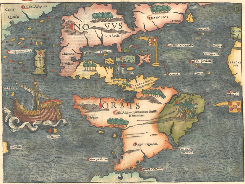
Novae Insulae, XVII Nova Tabula (1540)
Münster’s map of the Americas is the most notable of the continental maps added to his edition of the Geographia. Because of the popularity of Münster’s work, this landmark map played a crucial role in shaping the perception of the Western Hemisphere. When the map was reissued in the Cosmographia starting in 1544, it popularized the name "America." The inclusion of the Sea of Verrazano -- the enormous unnamed body of water that nearly bisects the eastern part of North America -- helped to inspire more British and French exploration in the region. They were looking for a Northwest Passage to the treasures of Cathay and the Spice Islands. Instead, they discovered a New World.
The map is the first to center on the Americas in their entirety. North America appears in an unusual, California-less configuration. Terra Florida is the only place name in the present-day United States, appearing in the Southeast beneath an east-west mountain range. Eastern Canada features a few place names: Francisca, C. Britonum, and the island Corterati (likely an early depiction of Newfoundland). In Mexico, the lake at Temistitan empties into the Gulf of Mexico, and the Yucatan is an island. South America has a large bulge in the southwest and a truncated Amazon River. An illustration in present-day Brazil warns of cannibals, with a head and leg ominously hanging from a hidden trap.
It is also the first printed map to name the Pacific Ocean (Mare Pacificum). The detail in the ocean reflects the influence of Marco Polo’s 13th-century explorations. An archipelago of 7,448 islands is located, and Japan (Zipangri) appears a short distance off the western coast of Mexico. The map pre-dates Europeans’ first encounter with Japan by three years, so its inclusion here is interesting. Ferdinand Magellan’s ship, the Victoria, is prominent in the South Pacific.
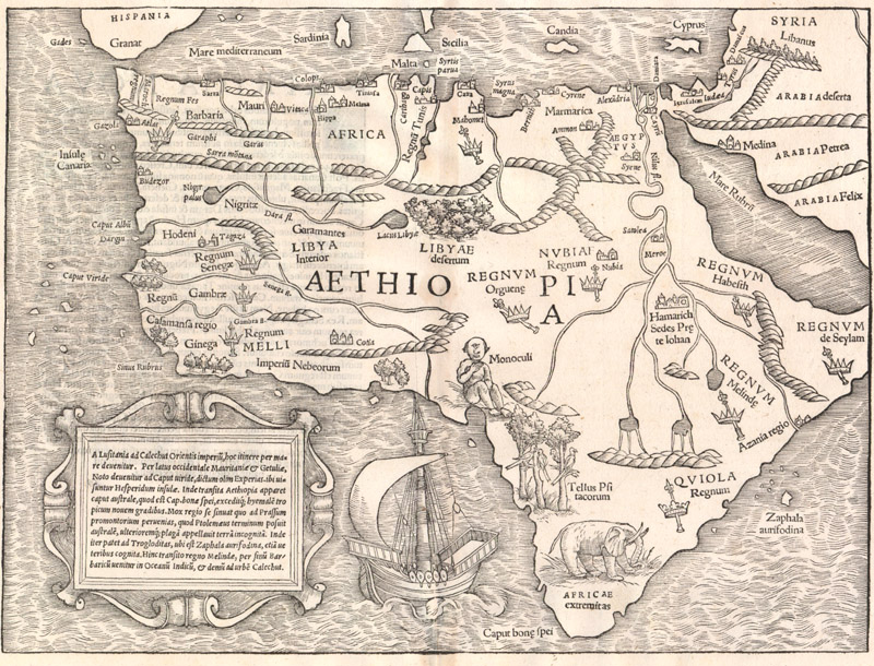
Africa XVIII Nova Tabula (1540)
According to Richard L. Betz, "This is the earliest, readily available, printed map to show the entire continent of Africa." Like Münster’s map of the Western Hemisphere, his map of Africa was first published in the Geographia in 1540 and was subsequently issued in the Cosmographia beginning in 1544. Due to the wide reach and influence of Münster’s work, the map likely defined the mysterious continent for generations of Europeans.
Münster combines Ptolemaic geography with more contemporary sources, selectively drawing on Portuguese and Arabic knowledge of the region. Africa’s general shape is taken from Münster’s own world map of 1532. He adheres to Ptolemy’s theory on the White Nile’s sources, tracing the river’s origins to twin lakes derived from the Mountains of the Moon. The Blue Nile emerges from a lake in the Abyssian Highlands. At the confluence of the Nile’s sources, Münster locates Hamarich, the capital of the mythical Christian king Prester John. Although Europeans had been aware of Madagascar since Marco Polo’s explorations, the island is strangely absent on this map.
The map is further distinguished by its memorable decorative elements. An iconic medieval Cyclops (Monoculi) reigns at the map’s center, a quintessential example of mapmakers adding fabulous creatures to maps of unknown regions. Illustrations of parrots and an elephant line the southwest coast. Scepters denote the various kingdoms. A large galleon sails the South Atlantic, next to a strapwork cartouche with Latin text describing European explorations along the coasts.
Gerard Mercator (1512-1594)
Coletta Hondius, "Gerardus Mercator…," 1638
Dubbed "the Ptolemy of our time" by friend and contemporary Abraham Ortelius, Gerard Mercator is generally considered one of the most significant cartographers of all time. Most notably, he invented the widely used Mercator’s projection and coined the term "atlas."
Mercator was born on March 5, 1512, in Rupelmonde, Flanders, about 10 miles from Antwerp. Beginning in 1530, he attended the University of Leuven, where he studied under Gemma Frisius, a key figure in the Golden Age of Netherlandish cartography in his own right. After receiving his degree in 1532, Mercator arranged an apprenticeship in astronomy and geography with Frisius and developed skills as a surveyor, cartographer, and builder of mathematical instruments. At the same time, he learned the art of copper engraving at the workshop of Gaspard van der Heyden. His first credited engraving job was on Frisius’1636 terrestrial globe, completed in van der Heyden’s shop.
The following year, Mercator published his first map, a six-sheet wall map of the Holy Land. He had made an official start as a mapmaker, and other credits soon followed. His cordiform world map of 1538 was the first to identify North and South America as separate continents (a concept first reiterated by Abraham Ortelius on his map of the Pacific, discussed in the section below). He also found success as a globe-maker, producing his own terrestrial globe in 1541 and a celestial globe a decade later.
In 1544, as the Roman Inquisition took hold in Flanders, Mercator was accused of being a Lutheran heretic for his correspondence with Franciscan friars. He was imprisoned in a castle in Rupelmonde for seven months, going free only after several local figures objected to the lack of evidence against him. Following this religious persecution, Mercator was able to return to his mapmaking with his support from the court still intact. He left Flanders for the more religiously tolerant Duisburg in 1552, pursuing opportunities at a new university planned by William, Duke of Cleve. While plans for the university came to naught, Mercator issued some of his most important work during this time, including large-scale maps of Europe (1554), the British Isles (1564), and the world (1569).
The 21-sheet world map of 1569 is Mercator’s most significant contribution to cartography. It is the first map to utilize Mercator’s proprietary projection. Rather than depicting the world as a rectangular grid of longitudes and latitudes, Mercator sought to create a more useful projection for navigators. He devised a cylindrical projection that extends the distance between parallels as they approach the poles. This allows for loxodromes or rhumbs (lines used to show a ship’s course) to be represented as a straight line.
Mercator was appointed Cosmographer to the Duke of Cleve in 1563-64, which inspired him to begin working on his 5-part cosmography of the world. The parts would cover creation, the heavens, geography (further subdivided into three parts: modern, Ptolemaic, and historical), history, and chronology. He started with the Chronology (1569), his version of the history of the world, which was subsequently banned by the Catholic Church for its mentions of Martin Luther and other Protestant heretics. Next, he tackled Ptolemy, publishing a faithful version of the Geographia in 1578.
As he put together his edition of Ptolemy, he began work on his modern atlas. Progress was slow; Mercator largely toiled alone as he compiled sources, wrote the accompanying text, drew the maps, and cut the plates. It would have been an ambitious project for a man of any age, but Mercator was in his seventies and plagued by increasingly bad health. He managed to complete three sections before his death in 1594.
His son Rumold published the "complete" Atlas Sive Cosmographicae Meditationes de Fabrica Mundi et Fabricati Figura in 1595. Although it lacked maps of Spain, Portugal, and the continents, this atlas included 78 previously published Mercator maps along with an additional 28 maps completed by Rumold. It was reissued again in 1602. In 1604, Mercator’s grandson Gerard sold the copperplates for his Geographia and Atlas to Jodocus Hondius and Cornelis Claesz.
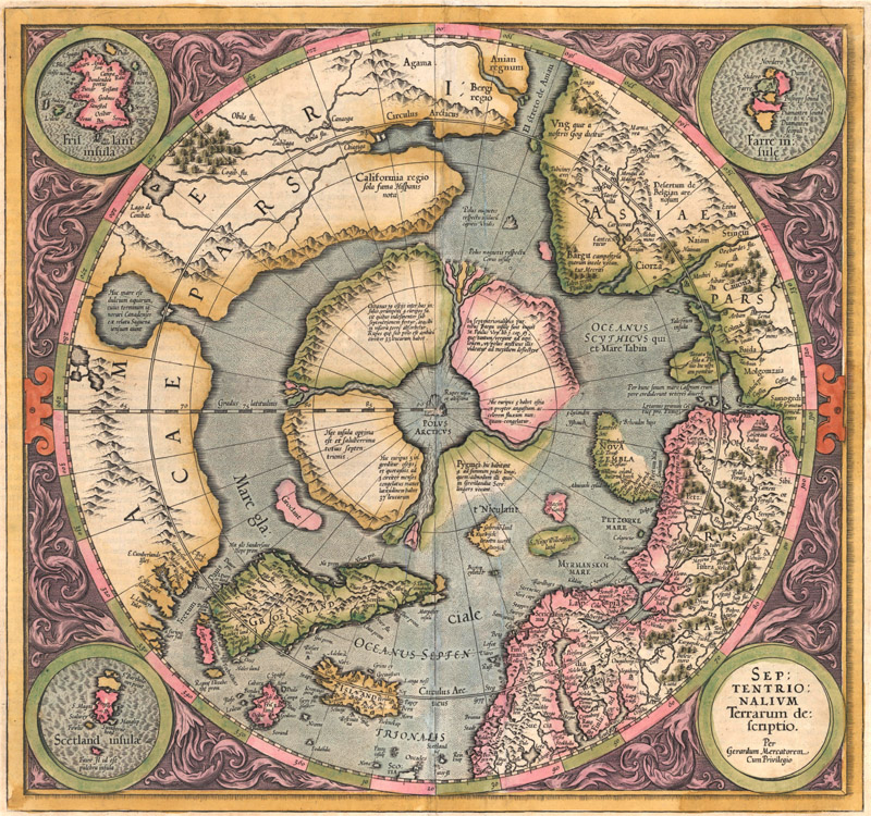
Septentrionalium Terrarum Descriptio (1595)
First published in the Atlas a year after Mercator’s death, this map is the first separately printed map devoted to the Arctic. Its depiction of the North Pole is rooted in myth, showing a whirlpool formed by four converging rivers with a mammoth rock at its center, all surrounded by a ring of large islands. According to a note, one of the islands is inhabited by pygmies. Another island rock, located just outside the polar mass, represents the magnetic north. The mythical island of Frisland appears in a roundel at top left.
Although the map is mostly sourced from an inset on Mercator’s 1569 world map, it has been updated with information from Martin Frobisher and John Davis’ searches for northern passages to Asia. The map includes an early reference to California, appearing for some odd reason to the north of El Streto de Anian. Pictured here is the second state of the plate, first published in 1606, featuring updates in the region north of Russia, including undefined coastlines to one of the islands surrounding the pole and Novaya Zemlya.
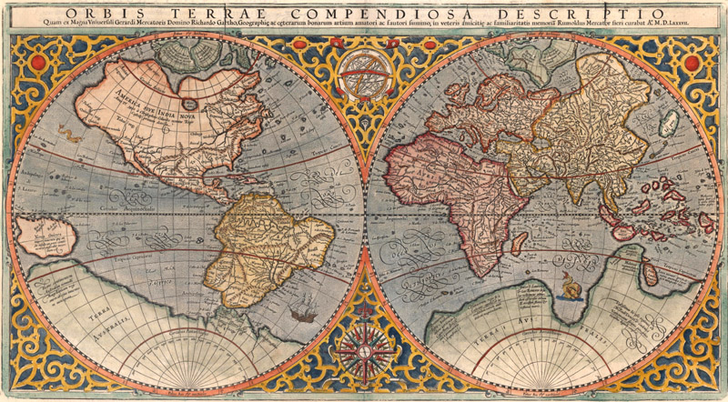
Orbis Terrae Compendiosa Descriptio quam ex Magna Universali Gerardi Mercatoris Domino Richardo Gartho... (1587)
According to Rodney Shirley, there are only three known copies of Mercator’s groundbreaking 1569 world map remaining in the world today. The next best thing for the collector is his son’s condensed double-hemisphere version of the map, first published in 1587, while the elder Mercator still lived. It is a beautiful map, surrounded by an elaborate strapwork border, with an armillary sphere and 32-point compass rose tucked between the hemispheres.
Rumold scrapped his father’s tricky new projection in favor of a double-hemispheric projection, but the geography largely remains the same. Gerard Mercator drew on an extensive list of sources for his 1569 map, including contemporaries such as Ortelius, Gastaldi, and Ramusio, as well as classical sources like Ptolemy, Pliny, and Mela. Mercator’s son copied this blend of ancient and modern authorities and propagated the many misperceptions and myths from his father’s map. Once again, the North Pole is delineated according to legend, and there is a clearly defined Northwest Passage. The southwest coast of South America has a swollen appearance. Tierra del Fuego is connected to the gargantuan Terra Australis, the fabulous southern continent that mapmakers copied for a century to come. Lucach, Maletur, and Beach, place names originating in the travel accounts of Marco Polo, also appear along the coast of the southern continent, in the vicinity of present-day Australia. New Guinea is depicted in a large, circular configuration. Satyrorum Insule, a trio of small, fictitious islands, hover above a kite-like Japan.
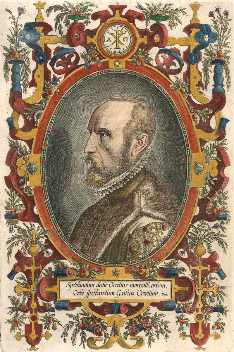
Abraham Ortelius (1527-1598)
Abraham Ortelius, "Spectandum Dedit Ortelius Mortalib. Orbem, Orbi Spectandum Galleus Ortelium," 1598
One of the pioneering figures of the Golden Age of Netherlandish cartography, Abraham Ortelius is best known for creating the first modern atlas, Theatrum Orbis Terrarum, in 1570.
Ortelius was born in Antwerp on April 4, 1527. As early as age 19, he was working with maps as an "afsetter," or colorist. He began to support his family as a trader in books, prints, and maps. This line of work brought him across Europe; he traveled to Belgium, Germany, France, Italy, and later England and Ireland and picked up multiple languages along the way. During a trip to the Frankfurt Book Fair in 1554, Ortelius met Gerard Mercator. Mercator was one of the key inspirations for Theatrum Orbis Terrarum, providing critical information and support. Mercator’s biographer Walter Ghim suggests that Mercator had conceived of his atlas before Ortelius but deliberately waited until his friend had found success with the publication of Theatrum before completing his own version. (The more likely story is that Mercator’s progress was slowed down by the hunt for reliable sources and his meticulous engraving process.)
At the time of its publication, Theatrum Orbis Terrarum was the most expensive book ever produced. Despite its high price tag, the atlas was an enormous success. For the first time, readers could purchase a uniform collection of maps, similar in size and bound together in one volume, with related text. Ortelius was scrupulous about citing his sources and asked readers to submit corrections and additional maps to improve and expand his atlas. From 1570 to 1612, 7,300 copies of Theatrum were published in 31 editions. Ortelius amended the atlas with Additamenta and Parergons, a series of maps focused on ancient history. The first edition included 70 maps on 53 sheets; the last edition ballooned to 167 maps. After the successful publication of the atlas, Ortelius was appointed His Majesties Royal Cartographer by Philip II of Spain.
Ortelius died in Antwerp on June 28, 1598. Posthumous editions were published by Jan Baptista Vrients, who purchased the rights from Ortelius’ heirs in 1601.
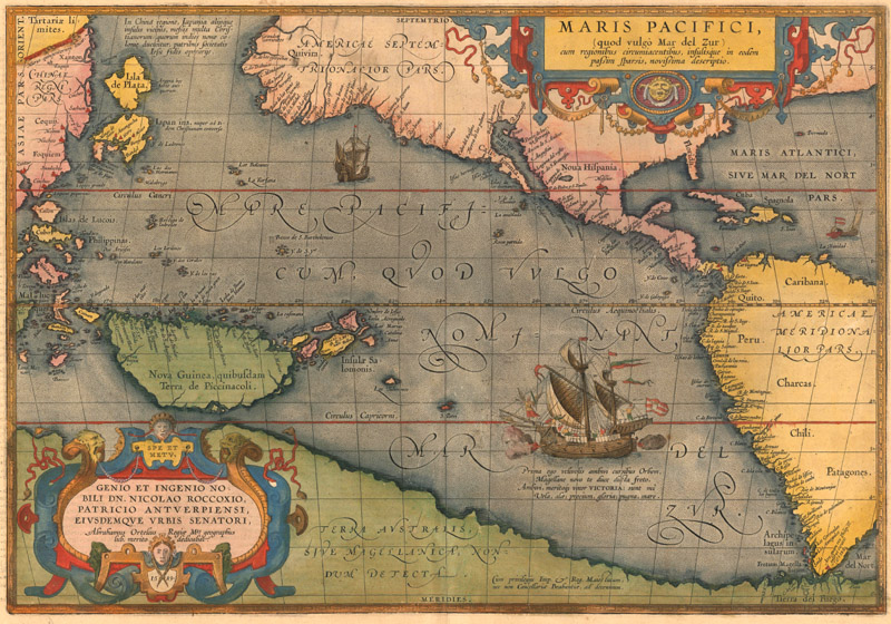
Maris Pacifici, (quod Vulgo Mar del Zur)… (1589)
Ortelius’ map of the Pacific Ocean is among the most sought after maps from Theatrum Orbis Terrarum. First published in the atlas in 1590, it is more uncommon than Ortelius’ earlier maps featuring the Americas. It is the first map to name both North and South America, after Mercator’s world map of 1538. Even more importantly, it is the first printed map to specifically focus on the Pacific, based on the up-to-date cartography of Frans Hogenberg, Mercator’s world map of 1569, and the Portuguese manuscript maps of Bartolomeo de Lasso. The map was the culmination of 16th century European knowledge of the ocean, published at a time when Spanish ships were exploring the western coast of the Americas and Manilla galleons were dodging English pirates on the route to Acapulco. As on Munster’s map of the Americas, Ferdinand Magellan’s pioneering voyage across the Pacific in 1520-21 is commemorated with a large illustration of his ship, the Victoria, in the South Sea (Mar del Zur).
Because it was not widely copied, the map’s depiction of the region remains unique and novel. Ortelius widens the gap between Asia and North America and properly locates the Philippines and Japan, although the mythical Isle of Silver (Isla de Plata) floats to the north of Japan. Within his work, Ortelius wavered on the question of whether or not New Guinea was an island; his 1570 world map shows it as one while his 1587 map of the Americas connects it to the southern continent. Here it is unambiguously delineated as an island. The map accurately narrows Hogenberg’s depiction of North America at the latitude of the Tropic of Cancer. California is depicted in peninsular form, with the first appearance of the R. Grande at the head of the Gulf of California. Following Mercator’s world map, Tierra del Fuego is part of the vast and mysterious Terra Australis.
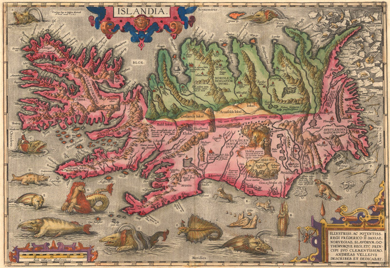
Islandia (1585)
Dated 1585, but first published in 1587, Ortelius’ map of Iceland is one of the pinnacles of decorative cartography. It fills the seas with an imaginative assemblage of beasts, with a lettered key on verso providing descriptions of each creature. Alongside its relatively realistic portrayal of whales, walruses, and polar bears, there are more fantastical monsters, among them a sea horse (complete with mane), a sea cow, and an aquatic hyena supposedly derived from the accounts of Swedish writer and cartographer Olaus Magnus. Ortelius attributes the cartography to Danish historian Andres Sorensen Vedel, who drew on a now-lost map by Bishop Gudbrandur Thorlaksson, a native Icelander who likely utilized early records of fjords, church documents, and his firsthand knowledge of his homeland as sources.
A New Way of Seeing the World
Münster, Mercator, and Ortelius ushered in the age of the modern atlas. Their trailblazing publications introduced the world to a new method of compiling and presenting maps. In the 17th century, mapmakers like the Hondius family, the Blaeu family, John Speed, and Nicolas Sanson would take their lead and further develop the atlas. We will discuss their contributions to cartographic history in our next newsletter.
References:
Betz, Richard L., The Mapping of Africa – A Cartobibliography of Printed Maps of the African Continent to 1700, Hes & De Graaf Publishers, ‘t Goy-Houten, 2007.
Burden, Philip D., The Mapping of North America – A List of Printed Maps 1511-1670, Raleigh Publications, Rickmansworth, 1996.
Monmonier, Mark, "Mercator’s Résumé," excerpted from Rhumb Lines and Map Wars: A Social History of the Mercator Projection, University of Chicago Press, Chicago, 2004. https://www.press.uchicago.edu/Misc/Chicago/534316.html (accessed 3/5/20).
Shirley, Rodney W., The Mapping of the World – Early Printed World Maps 1472-1700, Holland Press Limited, London, 1987.
Shirley, Rodney W., Maps in the Atlases of the British Library – A Descriptive Catalogue c. AD 850-1800 – Volume 1, The British Library, London, 2004.
Sigurðsson, Haraldur, Image of Iceland – Milestones in Cartography, The Culture House, Reykjavik, 2002.
Suárez, Thomas, Early Mapping of the Pacific – The Epic Story of Seafarers, Adventurers, and Cartographers Who Mapped the Earth’s Greatest Ocean, Periplus Editions, Singapore, 2004.
Van den Broecke, Marcel P.R., Ortelius Atlas Maps – An Illustrated Guide, HES Publishers, ‘t Goy-Houten, 1996.
Van der Krogt, Dr. Peter, Koeman’s Atlantes Neerlandici Volume I, HES Publishers, ‘t Goy-Houten, 1997.
Free Online Content for Cartophilesby Eliane & Jon Dotson
We are living in challenging and unprecedented times with the global spread of Covid-19. We hope that you and your loved ones are staying safe and finding opportunities to connect with one another. Fortunately many of the measures currently advised have been in common practice at OWA for many years due to the requirements to handle antique maps and our small staff size. As a result, we are able to continue our normal operations and plan to keep working as long as it is prudent to do so. (We expect to move forward with our April 15 auction as planned.) The only big change is that we are now learning how to operate while homeschooling our kids in the office (due to school closures), and we feel very lucky that our work situation allows us this flexibility.
As everyone copes with the challenges of staying at home, we have been amazed and inspired by all of the free online resources that are now available to educate, inform, entertain, and connect us. Museums, zoos, teachers, theaters, small businesses, and individuals have created online content and experiences, bringing rich resources from around the world to your computer. If you are looking to satiate your need for cartographic content while you remain confined, you may want to check out some of these free online resources:
Library of Congress Maps Blog. Both the collections and the staff of the Geography & Map Division of the Library of Congress are incredible resources, and there is a blog dedicated to highlighting some of the maps in their collection. To view the blog click here.
The Bodleian's Map Room Blog. Not to be outdone, the Bodleian Library at the University of Oxford also has a blog about "items of interest from the wonderful world of maps." To read the blog click here.
PJ Mode Collection of Persuasive Cartography. Housed on the Cornell University Library website, this collection of over 800 thoroughly catalogued maps focuses on "maps intended primarily to influence opinions or beliefs." You can view the maps in high resolution, read about each map's historical significance, and even download the map images to your own computer. Click here to view the collection.
"New Projections" Podcast. Curtis Bird, owner of The Old Map Gallery in Denver, Colorado has a podcast that focuses on map-related topics. You can download it though the Apple podcasts app, the Google podcasts app, or listen to it from your computer by clicking here.
Miniature Maps. This "illustrated guide to miniature antique maps, charts, plans and atlases" was created by Geoffrey L. King and is the definitive resource on this subject. Lose yourself in a tiny world by clicking here.
The Map Room Blog. This blog by Jonathan Crowe "covers everything from antique map collecting to the latest in geospatial technology" and represents curated content drawn from all over the internet. You can search through the archive to find specific topics. Click here for the blog.
OWA Newsletter Archive. This is actually our 54th newsletter, and all of our previous newsletters are available in an archive on our website. We have dozens of articles on mapmakers, cartographic curiosities, collecting tips, and more. Check out our newsletter archive here.