The Mapmakers Who Made the 17th Centuryby Eliane Dotson
We continue our survey of mapmakers over the centuries with four of the most prolific publishers of the seventeenth century: the Hondius family, the Blaeu family, John Speed, and Nicolas Sanson. (To read our article on sixteenth century mapmakers, click here.) Known as the Golden Age of Cartography, the seventeenth century was dominated by the Dutch, due in large part to the success and prosperity of Dutch exploration and trade. As wealth increased so did the middle class and their desire for cultural goods. These new customers were interested in maps and atlases, particularly about newly discovered lands, but they also saw them as symbols of their status that they could proudly display in their homes. Mapmakers responded by hiring the most skilled engravers, including lavish embellishments on their maps, and coloring atlases to order. The end result was a work of art, making seventeenth century maps some of the most popular even today.
Hondius Family - Jodocus Hondius Sr. (1563-1612); Jodocus Hondius Jr. (1593-1629); Henricus Hondius (1596/7-1651)
Like so many businesses in the 16th and 17th centuries, engraving, mapmaking and publishing were family enterprises, resulting in the personal and professional relationships of Dutch mapmakers being intricately interwoven. Jodocus Hondius Sr. was born in Flanders in 1563 but moved to London in 1584 where he focused on his skills as an engraver and instrument maker. In London he met numerous scholars, explorers, engravers and mapmakers, which guided his career further towards engraving and cartography. Hondius Sr. married Colette van den Keere, the sister of the well-known engraver Pieter van den Keere (Petrus Kaerius). They had three children: Elisabeth Hondius (who later married Johannes Janssonius, also known as Jan Jansson), Jodocus Hondius Jr., and Henricus Hondius. After moving to Amsterdam in 1593, the Hondius and Van den Keere families met Petrus Plancius and Cornelis Claesz., with whom they collaborated on several projects.
Jodocus Hondius Sr. and Claesz. acquired Gerard Mercator's copperplates around 1604, and this key step enabled the Hondius family to evolve from engravers to publishers. Hondius Sr. and Claesz. published a new edition of Ptolemy's Geographia and a revised edition of Mercator's unfinished Atlas, adding 36 new maps. Hondius Sr. also had small versions of Mercator's maps engraved and published them in the popular Atlas Minor beginning in 1607. After Jodocus Sr.'s death in 1612, the business was continued by his wife, sons, and son-in-law, Jansson. They completed both joint projects, including editions of the Atlas and Atlas Minor, the Atlas Novus, and a pair of large globes, as well as solo projects, such as Jodocus Jr.'s Theatrum Geographiae Veteris with Petrus Bertius.
After Jodocus Jr.'s death in 1629, his copperplates were sold to Willem Jansz. Blaeu, the biggest competitor to the Hondius-Jansson firm. Unfortunately this gave Blaeu an advantage in the publishing business, and Henricus Hondius and Jan Jansson soon responded by engraving copies of the plates that had been sold to Blaeu. Hondius-Jansson and Blaeu competed with one another with very similar copies of an Appendix to Mercator's Atlas in 1630 and the multi-volume Atlas Novus in 1640.
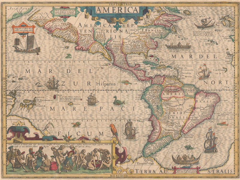
America (1606)
The decorations on Jodocus Hondius' map of the Americas, including sea monsters, indigenous birds, native canoes and sailing vessels, are taken from De Bry's Grand Voyages. Particularly notable is the scene of natives preparing an intoxicating drink made from manioc roots, which is derived from Hans Staden's harrowing venture into Brazil. The continents are presented on a stereographic projection, which was becoming increasingly popular at the beginning on the 17th century. It presents a more correct western coastline of South America and narrows the breadth of Mexico. However, North America is still too broad and Virginia has an exaggerated coastline.
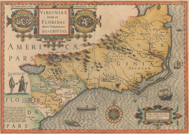
Virginiae Item et Floridae Americae Provinciarum, Nova Descriptio (1606)
This stunning map was compiled from two of the most important source maps of the early colonial period: John White's Virginia and Jacques le Moyne's Florida. Hondius' map became the prototype map of the region for the first half of the 17th century and continued to influence the cartography of the region until the middle of the 18th century. Largely due to the enormous success of Hondius' Atlas, Le Moyne's erroneous depiction of a large inland lake (Lacus aquae dulcis) from which the R. de May (St. John's River) flows in a southeasterly direction was popularized. Chesapeake Bay, here called Chesepioock Sinus, and the area south towards C.S. Romano Hispanis are shown in their White delineations. The Indian villages of Paquiwok, Croatoan, and Wococon are named in the Outer Banks and several others along the Albemarle and Pamlico Sounds. The map is extensively decorated with depictions of Indian villages incorporated in the title cartouche, a Floridian king and queen and Virginian natives in a canoe taken from De Bry, wildlife including a wild turkey, ships, sea monsters and a superb compass rose.
Blaeu Family - Willem Janszoon Blaeu (1571-1638); Joan Blaeu (1597-1673); Cornelis Blaeu (ca. 1610-42)
Willem Janszoon was born about 50 kilometers north of Amsterdam, and had the fortune to train in astronomy and the sciences in Denmark with celebrated astronomer, Tycho Brahe. His first cartographic work was a celestial globe based on the observations of Brahe. At the turn of the century Willem founded a globe and instrument business in Amsterdam, which was quickly becoming one of the wealthiest trading cities in Europe. Willem's business expanded to include publishing maps, charts and atlases, with some of his early works being maps of the world and continents in 1605-6 and a marine atlas, Het Licht der Zeevaerdt (The Light of Navigation), which went through many editions between 1608-30.
In 1618 Jan Jansson established his business next door to Willem's shop, which caused some confusion as Willem was publishing under the name Willem Jansz. or Guilelmus Janssonius. To prevent any misunderstandings, he changed his family name around 1621 to Blaeu after his grandfather, who was known as "blauwe Willem" (blue Willem).
Blaeu had ambitions to publish a world atlas, and purchasing Jodocus Hondius Jr.'s copperplates after his death in 1629 enabled him to complete this project. The Atlantic Appendix included 37 of the purchased copperplates (with Blaeu's name replacing that of Hondius Jr.'s) and 23 new ones. This endeavor appeared to increase the rivalry between Blaeu and the Hondius-Jansson firm, and the two publishing houses battled one another with atlases containing an increasing number of maps. In 1634 Blaeu published his Novus Atlas with around 200 maps and German text; Latin, French and Dutch editions followed in 1635 under the title Theatrum Orbis Terrarum.
After Willem's death in 1638, his sons, Joan (or Johannes) and Cornelis, took over the business. As Cornelis died a few years later, Joan became the sole proprietor and embarked on an ambitious project to further compete with Johannes Jansson: Atlas Maior. Although Joan's original concept for the Atlas Maior never came to fruition, the final work contained around 600 maps and was published in 9-12 volumes (depending on the edition) from 1662-72. In 1672 the Blaeu publishing house suffered a devastating fire, destroying one of the printing presses and many copperplates. Joan Blaeu died the following year, and his remaining stock and copperplates were sold to Frederick de Wit, Pieter Schenk and Gerard Valck, among others.
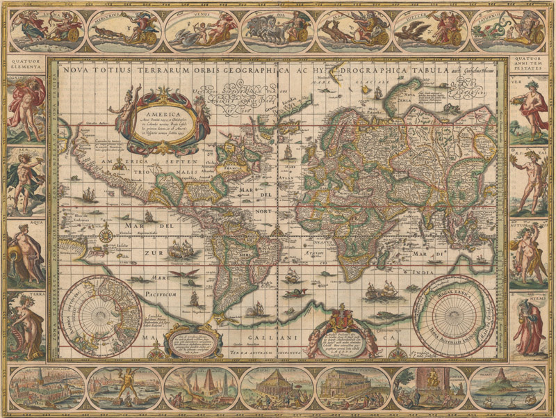
Nova Totius Terrarum Orbis Geographica ac Hydrographica Tabula (1606)
A magnificent map featuring a carte-a-figures border with allegorical representations of the sun, the moon, the five known planets, the four elements and the four seasons. Along the bottom are vignettes showing the seven wonders of the world: the Hanging Gardens of Babylon; the Colossus straddling the harbor at Rhodes; the Pyramids; the Mausoleum of Halicarnassus in Bodrum, Turkey; the Temple of Diana; the Statue of Jupiter; and the lighthouse at Alexandria. Josua van Ende engraved this map, reducing it from Blaeu's 1605 wall map for inclusion in atlases.
Petrus Plancius' world map of 1592 was the main source of geographical information. The map is shown on Mercator's projection with a massive Southern Continent attached to New Guinea, with the coastal names of Beach and Psittacorum regio noted from Marco Polo's travel memoirs. North America has the westward bulge characteristic of the time, with the Strait of Anian noted. Korea is shown as an island and Japan is in a kite-like shape. The map itself is richly decorated with cartouches, sea battles, monsters and compass roses.
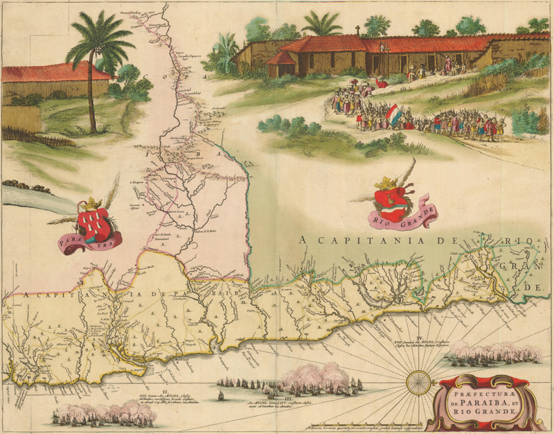
Praefecturae de Paraiba, et Rio Grande (1647)
This superb map of the Brazilian coastline includes the capitanias of Paraiba and Rio Grande. The map was drawn after actual surveys by Georg Markgraf, Elias Herckmanns and others, and was among the first maps of Brazil based on non-Portuguese data. The map is richly engraved with a huge scene of a procession of Tupinamba Indians carrying a French flag, part of a sugar mill, and three major sea battles depicted in the sea. The series of four maps of the capitanias of Brazil are unlike any other map in Blaeu's atlases. Blaeu first issued this and its companion maps in 1647 for Gaspar Barleus' Rerum per octennium in Brasilia. They were also assembled into a large wall map, Brasilia qua parte paret Belgis; the places where the sheets overlapped are marked by faint lines at left. The maps then appeared in the Atlas Maior beginning in 1662.
John Speed (1552 - 1629)
Born in Cheshire, England in 1552, John Speed began his career as a tailor in his father's business. Over time he caught the attention of educated individuals who offered Speed allowances in order for him to focus on research and intellectual pursuits full time. His primary interests were history and cartography, and he published his first map, Canaan as it was Possessed both in Abraham and Israels Dayes, in 1595.
One of Speed's most defining works, however, was his History of Great Britaine, which was first published in 1611 and was accompanied by an atlas volume the following year. The atlas, The Theatre of the Empire of Great Britaine, contained the first set of individual county maps of England and Wales, as well as maps of Scotland and Great Britain. The majority of the maps were engraved in Amsterdam by Jodocus Hondius and exemplified artistic mapmaking with city plans, armorial shields, vignettes of battles, and other decorative details. The first edition was published by John Sudbury and George Humble, and was subsequently published a number of times through 1676 by other publishers, including Hodocus Hondius, Johannes Blaeu, William Humble, Roger Rea, Thomas Bassett and Richard Chiswell.
Beginning in 1627, just two years before Speed's death, the History of Great Britaine was often bound with his world atlas. A Prospect of the Most Famous Parts of the World was the first world atlas published by an Englishman and included 21 maps of the world, continents, various countries in Europe and Asia, and the Bermudas. Highly prized for their decorative borders, these maps included images of costumed figures of the region ranging from nobility to country folk, as well as bird's-eye views of important cities. Speed's Prospect was also published in multiple editions through 1676 by George Humble, William Humble, Roger Rea, Thomas Bassett and Richard Chiswell. The final edition in 1676 is notable for the addition of eight new maps compiled by Thomas Bassett and Richard Chiswell, including those of Virginia and Maryland, New England, Carolina, and Jamaica.
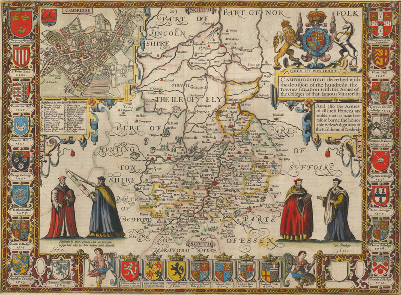
Cambridgshire Described with the Devision of the Hundreds, the Townes Situation, with the Armes of the Colleges of that Famous Universiti (1610)
This is one of the county maps published in The Theatre of the Empire of Great Britaine, and is considered one of the most decorative maps of Cambridgeshire. The map is flanked with University armorials with the dates of their founding. The coats of arms of Dukes and Earls form a border along the bottom. The map was drawn and updated from the surveys of Norden and Saxton and is filled with detail. Four university scholars and a bold title cartouche topped with the royal arms further adorn the map. The composition is completed with an inset plan of Cambridge with a key to the colleges and churches.
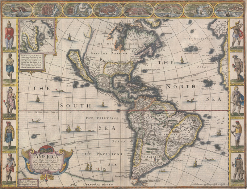
America with Those Known Parts in That Unknowne Worlde Both People and Manner of Buildings Discribed and Inlarged (1626)
This English map of the Americas is the earliest folio atlas map to depict California as an island, thus propagating one of the most enduring cartographic myths. It is also significant for its accurate depiction of the coast between Chesapeake and Cape Cod, and early portrayal of the English colonies, Iames Citti (Jamestown) and Plymouth. Boston and Long Island are not shown. The spurious islands of Brasil and Frisland still appear in the Atlantic. An inset map shows Greenland and Iceland. The map is the superb workmanship of the Dutch engraver, Abraham Goos. It is decorated in the popular carte-a-figures style with panels of costumed native figures at each side and vignettes of major cities at top. The figures at left represent the native people of North America, and at right the major South American tribes. The cities illustrated include Havana, Mexico City, Rio de Janeiro, Cusco, and other important South American settlements. A number of sea monsters, flying fish and sailing ships also decorate the map.
Nicolas Sanson (1600 - 1667)
Nicolas Sanson was one of the foremost French cartographers of the 17th century, and is often considered as the "father" of French cartography. Born in Abbeville in December 1600, Nicolas Sanson was educated by the Jesuits in nearby Amiens. He studied history, and it is believed that he turned to cartography simply as a means to illustrate history. One of his first cartographical enterprises was a 6-sheet map of ancient Gaul, published in 1627, although Sanson apparently had begun drafting the map as young as 18 years of age. His maps soon came to the attention of Cardinal Richelieu, King Louis XIII's chief minister, and Sanson was asked to tutor the king in geography. Louis XIII later appointed Sanson "Geographe Ordinaire du Roy" (Geographer to the King). This appointment helped both expand and protect Sanson's role in the French map market.
Over his career, Nicolas Sanson created around 300 maps - some on his own and others through collaborations. The most significant works that Sanson edited on his own were his quarto atlases of the four continents (L'Europe, L'Asie, L'Afrique, and L'Amerique) which he published between 1647-57. These small atlases of the continents proved hugely popular and were republished and copied by various map publishers through the early eighteenth century.
Sanson developed several important partnerships with engravers and printsellers over the years, first with Melchoir Tavernier and later with Pierre Mariette. Sanson created one of his most important works with Mariette, Cartes Generales de Toutes les Parties du Monde, which first appeared in 1658 and was the first full French world atlas. The first edition of this folio atlas included over 100 maps, and new maps were included in several editions though 1676. As Mariette died in 1657 and Sanson in 1667, the later editions were published by their sons, Pierre Mariette II and Guillaume Sanson. To read more about Sanson and Mariette's partnership, click here.
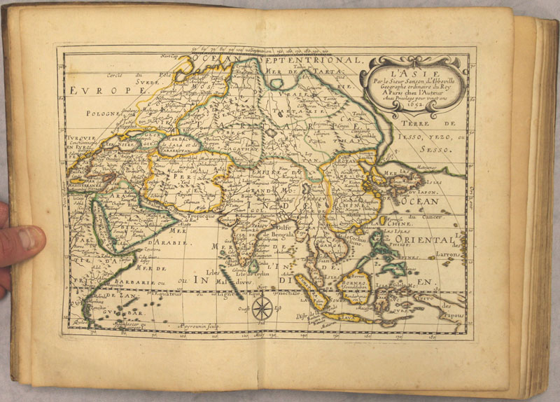
L'Asie en Plusieurs Cartes Nouvelles, et Exactes; & en Divers Traitte's de Geographie, et d'Histoire... (1658)
Sanson's small atlas of Asia contained 17 maps accompanied by corresponding text. Sanson credits numerous sources for the maps and text, including the ancient geographers (Ptolemy, Pliny and Holy Scripture), the Arabs Al-Idrisi and Oulough Beg, the histories of explorers by Linschoten and Samuel Purchas, and the great Dutch cartographers of the 16th and early 17th centuries (Mercator, Hondius, Jansson, Blaeu and Visscher). Sanson also acknowledges the work of the Jesuits for his maps of China and Japan. In particular, the map of Asia is important in the cartographic development of the region. It diverges from Sanson's folio map of 1650 in the appearance of a new landmass to the north of Japan labeled Terre de Iesso, Yezo ou Sesso. Sanson's depiction of this region is a combination of the reports of recent Dutch discoveries by De Vries and speculations of De Gama's discovery of a large landmass in the north Pacific. Japan is shown based on Jesuit sources and Korea is a globular-shaped island.
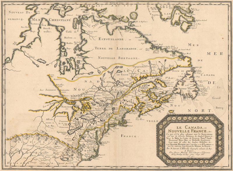
Le Canada, ou Nouvelle France, &c. (1656)
This is one of the most influential seventeenth century maps of the French and English colonies in North America. It concentrates on the region of greatest French interest with the boundary lines reflecting the French version of territorial boundaries. Sanson based the map primarily on Jesuit sources, retaining Champlain's basic cartographic model for the northern parts of Canada. He added some nomenclature of James, Foxe, and Button and retained the earlier concept of Button's Northwest Passage, in the southwest corner of the bay. The most important aspect of the map is the first appearance of L. Erie, ou du Chat as a recognizable lake. This delineation influenced the cartography of the region for over 100 years and was not superceded until Delisle's Carte du Canada in 1703. The entire Great Lakes basin and the St. Lawrence River are shown in great detail, with Lake Superior and Michigan (Lac du Puans) left open-end to the west. Other geographical improvements introduced with this map include a more detailed Hudson Bay, the introduction of Long Island, and the correct position of New Amsterdam.
The End of the Golden Age of Cartography
At the time they were published, Hondius, Blaeu, Speed and Sanson's maps gave Europeans a window into newly explored regions. Not only did their maps show geography, they also depicted images of the mysterious peoples, customs, and animals that could be found in these foreign lands. Europeans were fascinated with exploration and knowledge and maps became increasingly sought-after by the affluent, setting the stage for wider distribution of maps and atlases in the eighteenth century. Our next newsletter will tackle the prominent mapmakers of the eighteenth century, during which the Dutch lost their stronghold on the map industry and were overtaken by the French and English.
References:
Burden, Philip D., The Mapping of North America – A List of Printed Maps 1511-1670, Raleigh Publications, Rickmansworth, 1996.
Moreland, Carl & David Bannister, Christie's Collectors Guides Antique Maps, Phaidon, Oxford, 1986.
Petto, Christine Marie, When France Was King of Cartography, Lexington Books, Lanham, Maryland, 2007.
Shirley, Rodney W., Maps in the Atlases of the British Library – A Descriptive Catalogue c. AD 850-1800 – Volume 1, The British Library, London, 2004.
Van der Krogt, Dr. Peter, [Introduction to] Atlas Maior of 1665, Taschen, China, 2006.
Van der Krogt, Dr. Peter, Koeman’s Atlantes Neerlandici Volume I, HES Publishers, ‘t Goy-Houten, 1997.
MORE Free Online Content for Cartophilesby Eliane & Jon Dotson
In our last newsletter we shared some of the free online resources that are now available to satiate your need for cartographic content while you remain confined. In case you missed it, we are repeating the list below, along with a few new items you may find interesting:
NEW! History of Cartography Project. Several volumes of the monumental History of Cartography project are available for free online. Click here.
NEW! Library of Congress Story Maps. Story Maps are "immersive web applications that tell the incredible stories of the Library’s collections through narrative, multimedia, and interactive maps." Click here for all of the LOC's Story Maps or click here for "Maps that Changed our World."
NEW! Article on Mapping Public Health. The Washington Map Society has just released a member's-only article that appeared in the Spring 2018 issue of The Portolan. Click here for a high-resolution version of Lauren Bouchard Killingsworth’s prize-winning article on “Mapping Public Health in Nineteenth-Century Oxford,” or click here for a low-resolution version.
NEW! How Maps Are Made. This lecture by Chris Lane of the Philadelphia Print Shop West was previously given at the Miami Map Fair and is available on YouTube by clicking here. Chris intends to add more lectures to his YouTube channel soon.
Library of Congress Maps Blog. Both the collections and the staff of the Geography & Map Division of the Library of Congress are incredible resources, and there is a blog dedicated to highlighting some of the maps in their collection. To view the blog click here.
The Bodleian's Map Room Blog. Not to be outdone, the Bodleian Library at the University of Oxford also has a blog about "items of interest from the wonderful world of maps." To read the blog click here.
PJ Mode Collection of Persuasive Cartography. Housed on the Cornell University Library website, this collection of over 800 thoroughly catalogued maps focuses on "maps intended primarily to influence opinions or beliefs." You can view the maps in high resolution, read about each map's historical significance, and even download the map images to your own computer. Click here to view the collection.
"New Projections" Podcast. Curtis Bird, owner of The Old Map Gallery in Denver, Colorado has a podcast that focuses on map-related topics. You can download it though the Apple podcasts app, the Google podcasts app, or listen to it from your computer by clicking here.
Miniature Maps. This "illustrated guide to miniature antique maps, charts, plans and atlases" was created by Geoffrey L. King and is the definitive resource on this subject. Lose yourself in a tiny world by clicking here.
The Map Room Blog. This blog by Jonathan Crowe "covers everything from antique map collecting to the latest in geospatial technology" and represents curated content drawn from all over the internet. You can search through the archive to find specific topics. Click here for the blog.
OWA Newsletter Archive. This is actually our 54th newsletter, and all of our previous newsletters are available in an archive on our website. We have dozens of articles on mapmakers, cartographic curiosities, collecting tips, and more. Check out our newsletter archive here.