Subject: Colonial Virginia, Maryland
Period: 1775 (dated)
Publication: Thomas Jefferys' American Atlas
Color: Hand Color
Size:
48.5 x 31 inches
123.2 x 78.7 cm
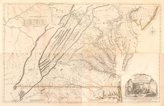
By the middle of the 18th century, there was a strong need for an updated map of the colony of Virginia, as no comprehensive map based on new surveys had been produced since Augustine Hermann’s map of 1673. George Montagu Dunk, Earl of Halifax and newly appointed president of the Board of Trade and Plantations in 1748, made this a top priority and immediately requested new details regarding the extent of English settlement on the frontiers and the potential French encroachment in those areas claimed by the British. In response to Lord Halifax's request, the acting governor of Virginia, Lewis Burwell, appointed Colonel Joshua Fry and Peter Jefferson (the father of Thomas Jefferson) to draw an updated map of Virginia.
Fry and Jefferson, then surveyor and deputy surveyor for Albemarle County respectively, were ideal appointees for the project as they had accumulated a substantial amount of information from their work on the backcountry, the Northern Neck controversy, and the westward extension of the border between Virginia and North Carolina. Their knowledge, along with reports received from their acquaintances who had explored the western territories, produced the most detailed account of the inhabited parts of the colony. In 1751, Fry and Jefferson produced a draft to governor Burwell (only one year after the request), and it was formally presented to the Board of Trade and Plantations in 1752. A major revision in 1755 incorporated new information about the western frontier from information collected by Fry, George Washington, and the journals of John Dalrymple and Christopher Gist.
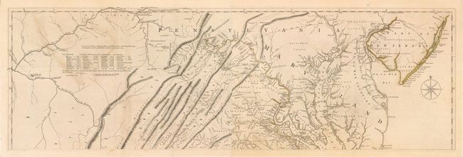
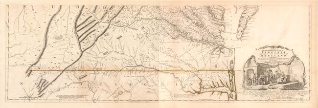
Cartographically, the map was the first to correctly orient the ridges of the Appalachian Mountains and the western flow of the New, Greenbrier and Monongahela Rivers. The map also depicts the "Great Waggon Road" that begins in Philadelphia and heads south through the Shenandoah Valley and into North Carolina. Both of these important features would serve as paths toward future population flow and development. Numerous early plantations are located including landowner's names. To the east the map shows the road from Williamsburg to Edenton, North Carolina and details the flow of rivers into Albemarle Sound.
The title cartouche in the lower right corner illustrates the tobacco trade, which was the backbone of Virginia’s economy. The major rivers in the Tidewater region were critical to this industry as they allowed for direct transport of the crops from plantations to ocean-going vessels. Eliminating the need for land transportation made the planters more profitable, and thus able to grow rapidly and capitalize on the significant amount of land accessible to the river system. Drawn by Francis Hayman and engraved by Charles Grignion, the vignette shows slave labor preparing the massive barrels of tobacco for transport to Europe while a wealthy merchant is served a beverage. At left a hogshead of tobacco spills onto the dock, visually representing the cornucopia or "horn of plenty."
This is the sixth state of eight known states. The first four states are essentially unobtainable. The fifth and sixth state are identical, with the only difference being the date change from 1768 to 1775. Published by Thomas Jefferys and Robert Sayer. Printed on four sheets and joined into two as issued, and would measure 48" x 31" if fully joined. The image shows the map sheets overlaid as if they were joined.
References: Stephenson & Mckee, pp. 52-55, 83; Pritchard & Taliaferro pp. 154-159; Cummings (SE) #281, #449.
Condition: B+
Strong impression on watermarked paper in original outline color. There are some areas of light offsetting, most notably on the upper sheet at left as well as some areas of light toning and a few minor spots. The map has been professionally removed from mounting board with the only evidence being some very light adhesive residue on verso that is not visible on the face of the map.