Filtered by Category:United States(Show All Categories)
Current Auction
166 lots
Page 1 of 4
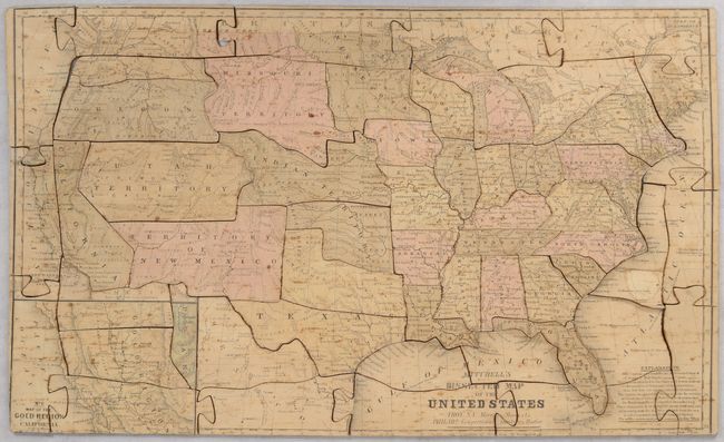
Lot 42
Subject: Cartographic Miscellany, Puzzle Map, United States
Mitchell/Cowperthwait/Desilver
Mitchell's Dissected Map of the United States, 1854
Size: 17.3 x 10.3 inches (43.9 x 26.2 cm)
Estimate: $500 - $650
Early and Rare American Puzzle
Sold for: $425
Closed on 6/18/2025
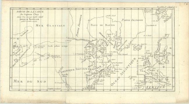
Lot 93
Subject: Colonial United States & Canada
Robert de Vaugondy, Didier
Carte des Parties Nord et Ouest de l Amerique Dressee d'Apres les Relations les Plus Authentiques par M... en 1764, 1772
Size: 15 x 11.7 inches (38.1 x 29.7 cm)
Estimate: $200 - $230
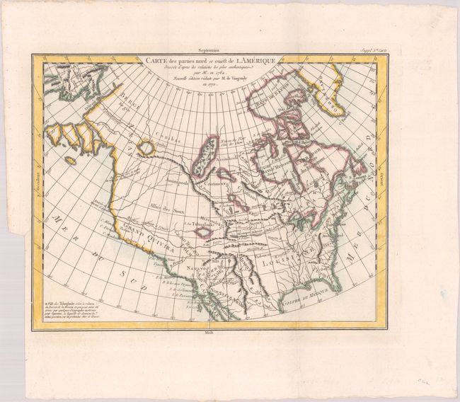
Lot 94
Subject: Colonial United States & Canada, Arctic
Robert de Vaugondy, Didier
Partie de la Carte du Capitaine Cluny Auteur d'un Ouvrage Anglois Intitule American Traveller Publie a Londres en 1769, 1773
Size: 16.4 x 8.6 inches (41.7 x 21.8 cm)
Estimate: $110 - $140
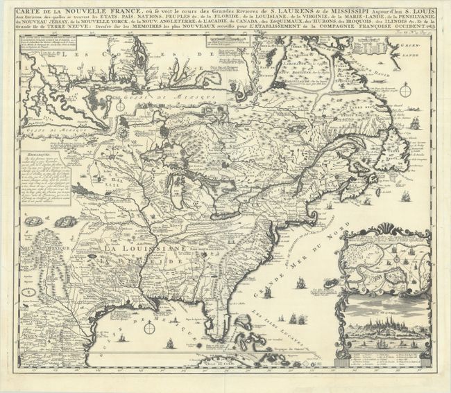
Lot 95
Subject: Colonial Eastern United States & Canada
Chatelain, Henry Abraham
Carte de la Nouvelle France, ou se Voit le Cours des Grandes Rivieres de S. Laurens & de Mississipi Aujour d'hui S. Louis, aux Environs des-quelles se Trouvent les Etats, Pais, Nations, Peuples, &c. de la Floride, de la Louisiane, de la Virginie..., 1719
Size: 19.3 x 16.7 inches (49 x 42.4 cm)
Estimate: $2,200 - $2,500
One of the Most Informative 18th Century Maps of the French Possessions in North America
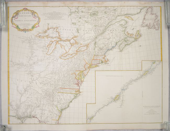
Lot 96
Subject: Colonial Eastern United States & Canada
Anville, Jean Baptiste Bourguignon d'
[On 4 Joined Sheets] Canada Louisiane et Terres Angloises, 1755
Size: 44.8 x 33.9 inches (113.8 x 86.1 cm)
Estimate: $1,400 - $1,700
D'Anville's Spectacular Map of Eastern Seaboard on 4 Joined Sheets
Sold for: $1,000
Closed on 6/18/2025
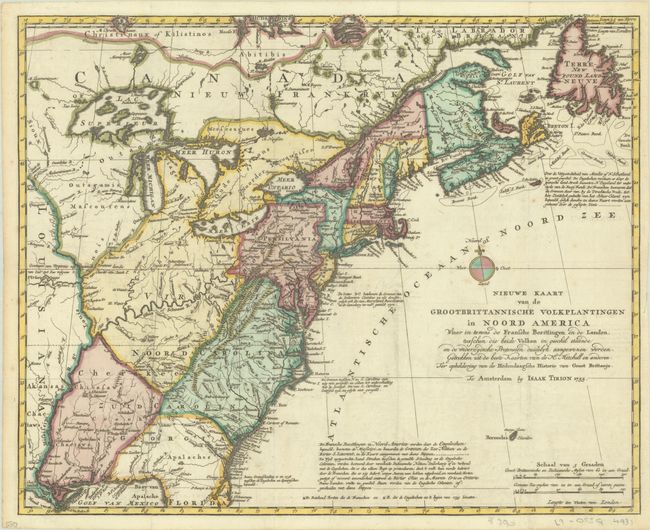
Lot 97
Subject: Colonial Eastern United States & Canada
Tirion, Isaac
Nieuwe Kaart van de Grootbrittannische Volkplantingen in Noord America waar in Tevens de Fransche Bezittingen en de Landen..., 1755
Size: 17.9 x 14.4 inches (45.5 x 36.6 cm)
Estimate: $600 - $750
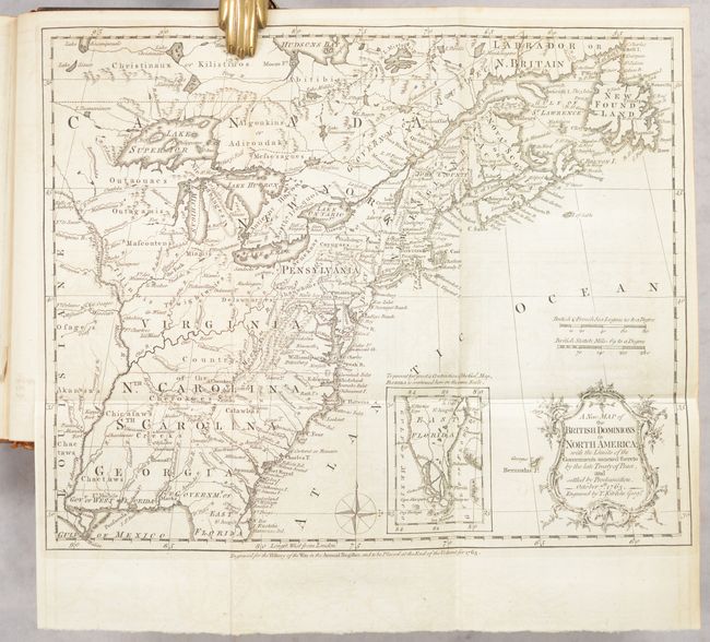
Lot 98
Subject: Colonial Eastern United States & Canada, History Book
Kitchin, Thomas
[Maps in Book] A New Map of the British Dominions in North America; with the Limits of the Governments Annexed Thereto by the Late Treaty of Peace... [bound in] The Annual Register, or a View of the History, Politicks, and Literature…, 1764
Size: 11.9 x 9.6 inches (30.2 x 24.4 cm)
Estimate: $600 - $750
Historical Map in First Edition Publication of Proclamation Ending French and Indian War
Sold for: $450
Closed on 6/18/2025
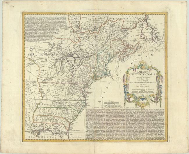
Lot 99
Subject: Colonial Eastern United States & Canada
Homann Heirs
America Septentrionalis a Domino d'Anville in Galliis Edita nunc in Anglia Coloniis in Interiorem Virginiam Deductis nec non Fluvii Ohio..., 1777
Size: 20.1 x 18.1 inches (51.1 x 46 cm)
Estimate: $700 - $850
Sold for: $1,100
Closed on 6/18/2025
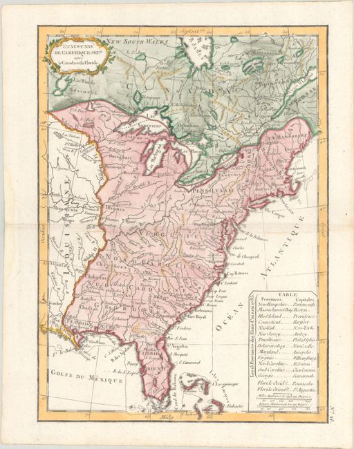
Lot 100
Subject: Eastern United States & Canada
Delamarche, Charles Francois
Etats-Unis de l'Amerique Seple. avec le Canada et la Floride, 1793
Size: 7.2 x 9.8 inches (18.3 x 24.9 cm)
Estimate: $200 - $230
Sold for: $150
Closed on 6/18/2025
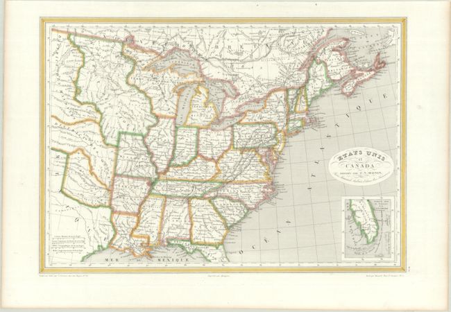
Lot 101
Subject: Eastern United States & Canada, Texas
Monin, Charles V.
Etats Unis et Canada, 1830
Size: 18.1 x 12.6 inches (46 x 32 cm)
Estimate: $180 - $210
Sold for: $130
Closed on 6/18/2025
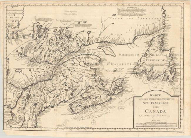
Lot 102
Subject: Colonial Northeastern United States & Canada
Bellin, Jacques Nicolas
Karte von dem Ostlichen-Stucke von Neu Frankreich oder Canada, 1744
Size: 21.9 x 15.6 inches (55.6 x 39.6 cm)
Estimate: $350 - $425
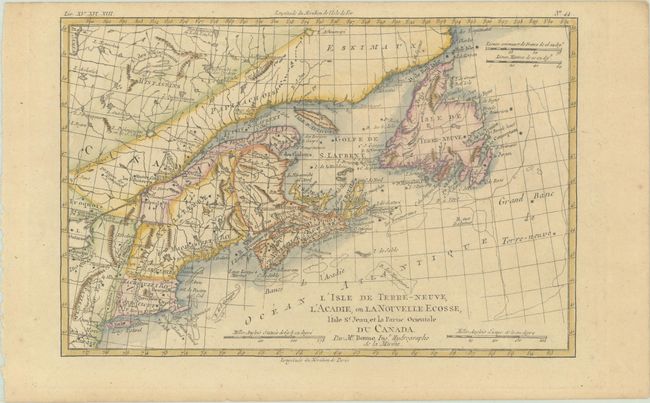
Lot 103
Subject: Colonial Northeastern United States & Canada
Bonne, Rigobert
L'Isle de Terre-Neuve, l'Acadie, ou la Nouvelle Ecosse, l'Isle St. Jean, et la Partie Orientale du Canada, 1780
Size: 12.5 x 8.3 inches (31.8 x 21.1 cm)
Estimate: $140 - $170
Sold for: $100
Closed on 6/18/2025
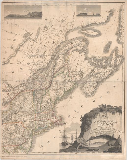
Lot 104
Subject: Northeastern United States & Canada
Bouchette, Joseph
[Eastern Sheet] Map of the Provinces of Upper & Lower Canada with the Adjacent Parts of the United States of America &c. Compiled from the Latest Surveys and Adjusted from the Most Recent and Approved Astronomical Observations, 1815
Size: 24.3 x 30 inches (61.7 x 76.2 cm)
Estimate: $2,400 - $3,000
Eastern Sheet of Bouchette's Rare Map Presenting Lower Canada and New England
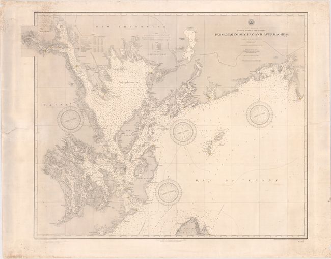
Lot 105
Subject: Passamaquoddy Bay & Bay of Fundy
U.S. Hydrographic Office
Passamaquoddy Bay and Approaches, 1891
Size: 36.6 x 28.9 inches (93 x 73.4 cm)
Estimate: $275 - $350
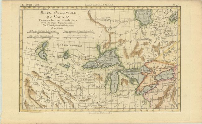
Lot 106
Subject: Colonial Great Lakes
Bonne, Rigobert
Partie Occidentale du Canada, Contenant les Cinq Grands Lacs, avec les Pays Circonvoisins, 1780
Size: 12.6 x 8.3 inches (32 x 21.1 cm)
Estimate: $240 - $300
Sold for: $180
Closed on 6/18/2025
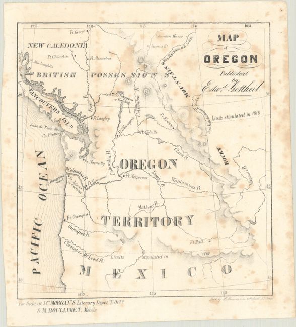
Lot 107
Subject: Northwestern United States & Canada
Map of Oregon, 1846
Size: 6 x 6.4 inches (15.2 x 16.3 cm)
Estimate: $110 - $140
Rare Map of Oregon Territory Published in New Orleans
Sold for: $80
Closed on 6/18/2025
Lot 108
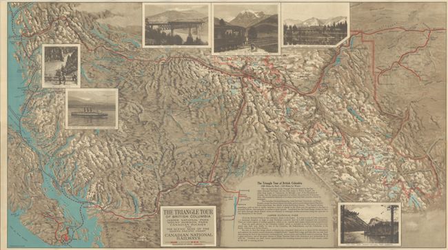
Subject: Northwestern United States & Canada
Railroad Companies, (Various)
The Triangle Tour of British Columbia - Jasper National Park Mount Robson Park Canadian Rockies and the Scenic Seas of the North Pacific Coast [on verso] Alaska and the Yukon, 1927
Size: 29.8 x 16.8 inches (75.7 x 42.7 cm)
Estimate: $140 - $170
Sold for: $100
Closed on 6/18/2025
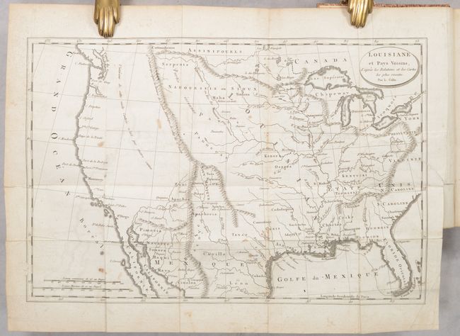
Lot 109
Subject: United States
Baudry des Lozieres, Louis Narciss
[Map in Book] Louisiane et Pays Voisins, d'Apres les Relations et les Cartes les Plus Recentes [in] Voyage a la Louisiane, et sur le Continent de l'Amerique Septentrionale..., 1802
Size: 5 x 8 inches (12.7 x 20.3 cm)
Estimate: $475 - $600
Sold for: $350
Closed on 6/18/2025
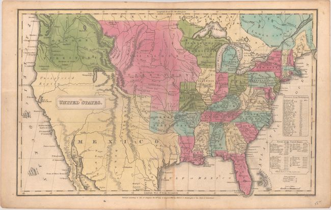
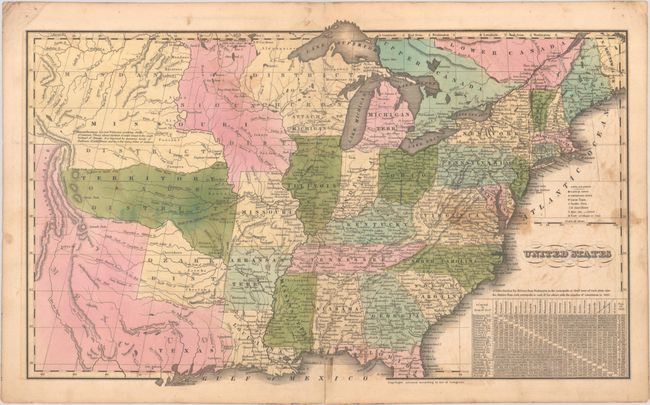
Lot 110
Subject: United States
Huntington, F. J.
United States, 1830
Size: 16 x 10.2 inches (40.6 x 25.9 cm)
Estimate: $160 - $190
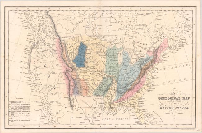
Lot 111
Subject: United States
Hinton, John Howard
A Geological Map of the United States, 1832
Size: 15.4 x 9.9 inches (39.1 x 25.1 cm)
Estimate: $240 - $300
Sold for: $180
Closed on 6/18/2025
Lot 112
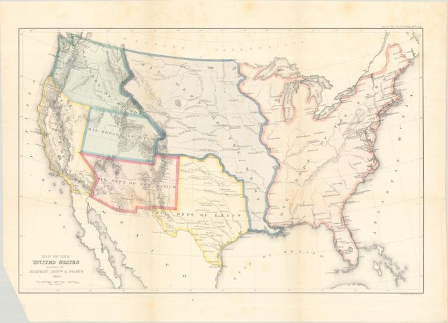
Subject: United States
U.S. Government
Map of the United States Exhibiting the Military Depts. & Posts, 1860
Size: 19.8 x 12.9 inches (50.3 x 32.8 cm)
Estimate: $300 - $375
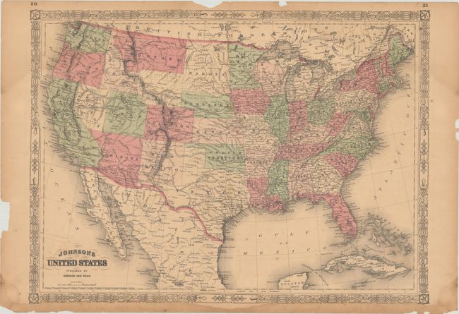
Lot 113
Subject: United States
Johnson and Ward
Johnson's United States, 1864
Size: 23.3 x 17.1 inches (59.2 x 43.4 cm)
Estimate: $90 - $120
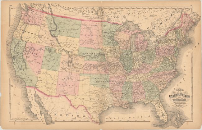
Lot 114
Subject: United States
Walling & Gray
Map of the United States and Territories, 1872
Size: 26.1 x 16.8 inches (66.3 x 42.7 cm)
Estimate: $180 - $220
Features an Orphaned "Part of Dakota"
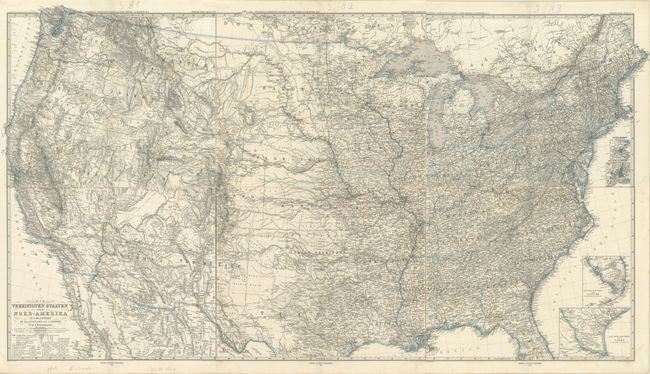
Lot 115
Subject: United States
Petermann, Augustus Herman
[On 6 Sheets] Die Vereinigten Staaten von Nord-Amerika in 6 Blattern, 1873
Size: 15.9 x 13.3 inches (40.4 x 33.8 cm)
Estimate: $240 - $300
Sold for: $180
Closed on 6/18/2025

Lot 116
Subject: United States
Donaldson, Thomas
Map of the United States Exhibiting the Grants of Lands Made by the General Government to Aid in the Construction of Railroads and Wagon Roads..., 1884
Size: 28.5 x 19.8 inches (72.4 x 50.3 cm)
Estimate: $250 - $325

Lot 117
Subject: United States
U.S. Bureau of Indian Affairs
Map Showing the Location of the Indian Reservations Within the Limits of the United States and Territories..., 1885
Size: 33.6 x 21.2 inches (85.3 x 53.8 cm)
Estimate: $160 - $190
Sold for: $120
Closed on 6/18/2025
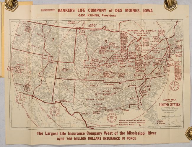
Lot 118
Subject: United States
Kenyon Company, The
Radio Map of the United States, 1925
Size: 21 x 13 inches (53.3 x 33 cm)
Estimate: $140 - $170
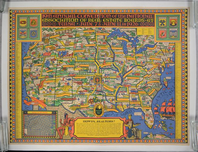
Lot 119
Subject: United States; Tulsa, Oklahoma
19th Annual Convention of the National Association of Real Estate Boards at Tulsa June 7 to June 11 in 1926, 1926
Size: 46.4 x 34.7 inches (117.9 x 88.1 cm)
Estimate: $1,100 - $1,400
Rare Pictorial Map that Shows All Roads Leading to the Real Estate Convention in Tulsa
Sold for: $800
Closed on 6/18/2025
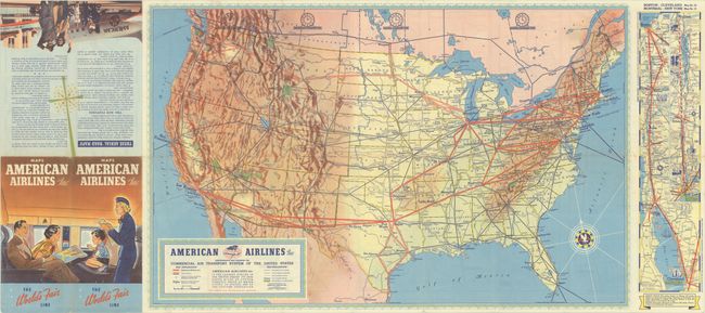
Lot 120
Subject: United States, Aviation
American Airlines Inc. Comprehensive Map Showing the Commercial Air Transport System of the United States, 1939
Size: 27.7 x 17.6 inches (70.4 x 44.7 cm)
Estimate: $180 - $220
A Very Early American Airlines Map
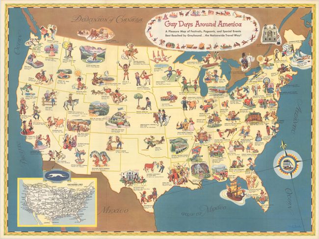
Lot 121
Subject: United States
Gay Days Around America - A Pleasure Map of Festivals, Pageants, and Special Events Best Reached by Greyhound... the Nationwide Travel Way!, 1949
Size: 23.4 x 17.5 inches (59.4 x 44.5 cm)
Estimate: $220 - $250
Sold for: $110
Closed on 6/18/2025
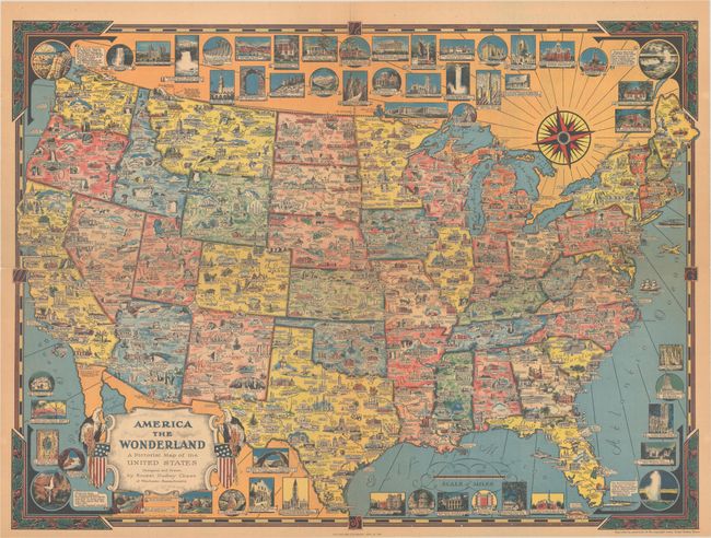
Lot 122
Subject: United States
Dudley Chase, Ernest
America the Wonderland - A Pictorial Map of the United States, 1954
Size: 27.9 x 20.6 inches (70.9 x 52.3 cm)
Estimate: $300 - $375

Lot 123
Subject: United States
U.S. Department of Interior
A Seafood Tour of the U.S.A. - A Cookery Compendium of Selected Seafoods for Delectable Dining, 1961
Size: 19.8 x 18.3 inches (50.3 x 46.5 cm)
Estimate: $140 - $170
Unusual Unrecorded Government Pictorial Map Promoting Seafood

Lot 124
Subject: United States
The National Rifle Association Pictorial Wildlife and Game Map of the United States, 1972
Size: 26.9 x 18.9 inches (68.3 x 48 cm)
Estimate: $240 - $300
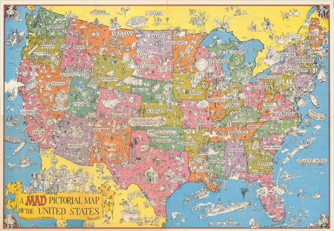
Lot 125
Subject: United States
A Mad Pictorial Map of the United States, 1981
Size: 28.9 x 20.2 inches (73.4 x 51.3 cm)
Estimate: $120 - $150

Lot 126
Subject: Northern United States
Map of the Pioneer Way - Oregon Trail Olympia to Kansas City - National Old Trails Road Kansas City to Washington, D.C. Showing Every City, Town, Village and Hamlet Throughout Its Entire Length..., 1916
Size: 45.8 x 16.5 inches (116.3 x 41.9 cm)
Estimate: $200 - $250
Early Persuasive Map Promoting a National Highway System
Sold for: $140
Closed on 6/18/2025
Lot 127
Subject: Eastern & Central United States
Huntington, Eleazor
United States, 1833
Size: 17.6 x 10.6 inches (44.7 x 26.9 cm)
Estimate: $110 - $140
Sold for: $80
Closed on 6/18/2025
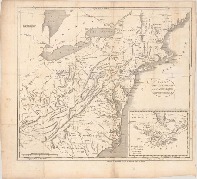
Lot 128
Subject: Eastern United States
Partie des Etats-Unis de l'Amerique Septentrionale, 1799
Size: 18.6 x 16.2 inches (47.2 x 41.1 cm)
Estimate: $180 - $220
Sold for: $130
Closed on 6/18/2025
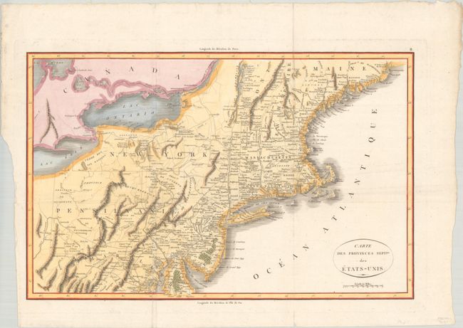
Lot 129
Subject: Eastern United States
Rochefoucald Liancourt, Francois Alexander
Carte des Provinces Septles. des Etats-Unis, 1807
Size: 19.9 x 12.8 inches (50.5 x 32.5 cm)
Estimate: $200 - $230
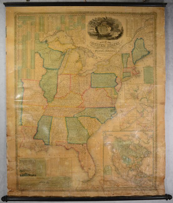
Lot 130
Subject: Eastern United States
Mitchell/Young
Map of the United States, 1845
Size: 34.7 x 43.5 inches (88.1 x 110.5 cm)
Estimate: $900 - $1,100
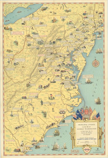
Lot 131
Subject: Eastern United States
Principal Events in the Life of George Washington in Those States That Lie Between the Hudson and Savannah, 1932
Size: 17.3 x 25.8 inches (43.9 x 65.5 cm)
Estimate: $160 - $190
Sold for: $120
Closed on 6/18/2025
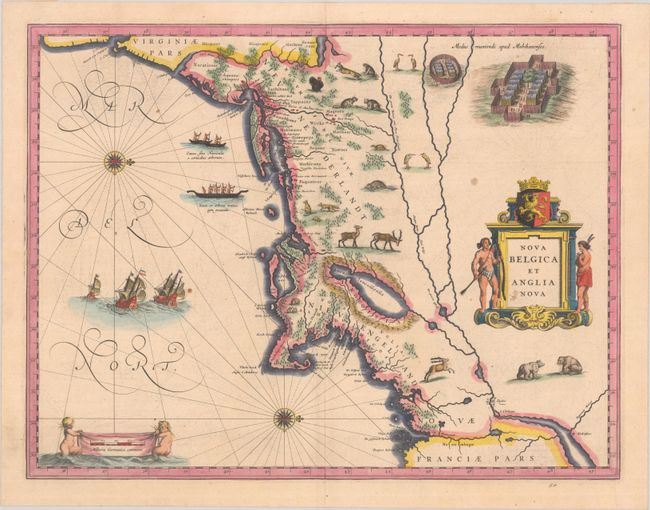
Lot 132
Subject: Colonial New England & Mid-Atlantic United States
Blaeu, (Family)
Nova Belgica et Anglia Nova, 1638
Size: 19.9 x 15.3 inches (50.5 x 38.9 cm)
Estimate: $1,600 - $1,900
Important Map of Colonial New England and the Mid-Atlantic
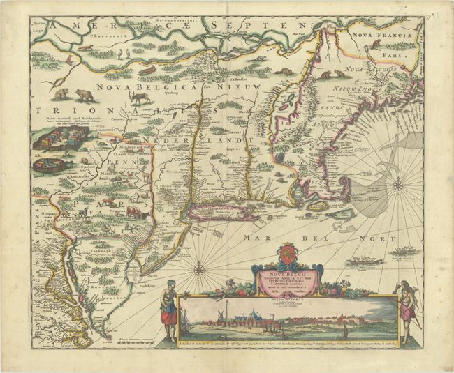
Lot 133
Subject: Colonial New England & Mid-Atlantic United States
Danckerts, Justus
Novi Belgii Novaeque Angliae nec non Pennsylvaniae et Partis Virginiae Tabula Multis in Locis Emendata, 1690
Size: 21.4 x 18.2 inches (54.4 x 46.2 cm)
Estimate: $4,000 - $4,750
Danckerts' Decorative Map with Early View of New York City in Full Contemporary Color
Sold for: $3,000
Closed on 6/18/2025
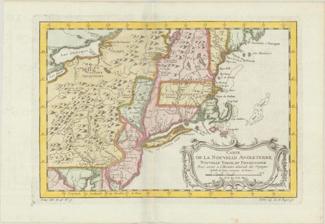
Lot 134
Subject: Colonial New England & Mid-Atlantic United States
Bellin, Jacques Nicolas
Carte de la Nouvelle Angleterre, Nouvelle Yorck, et Pensilvanie. Pour Servir a l'Histoire Generale des Voyages, 1757
Size: 11.8 x 8.1 inches (30 x 20.6 cm)
Estimate: $220 - $250
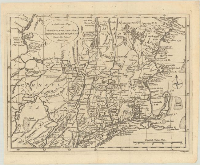
Lot 135
Subject: Colonial New England & Mid-Atlantic United States
Lodge, John
An Exact Map of New England, New York, Pensylvania & New Jersey, from the Latest Surveys, 1777
Size: 10.1 x 7.6 inches (25.7 x 19.3 cm)
Estimate: $350 - $425
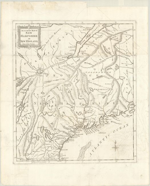
Lot 136
Subject: Colonial New England United States
Anon.
An Accurate Map of New Hampshire in New England, from a Late Survey, 1781
Size: 11.1 x 12.7 inches (28.2 x 32.3 cm)
Estimate: $325 - $400

Lot 137
Subject: New England United States
Johnson & Browning
Johnson's New England, 1860
Size: 17 x 24 inches (43.2 x 61 cm)
Estimate: $70 - $90
NO RESERVE
Sold for: $100
Closed on 6/18/2025
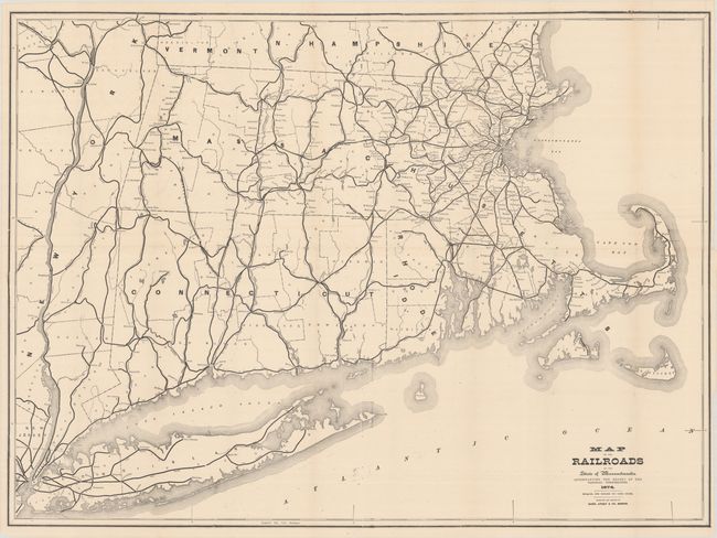
Lot 138
Subject: New England United States
Rand, Avery & Co.
Map of the Railroads of the State of Massachusetts..., 1874
Size: 38 x 28 inches (96.5 x 71.1 cm)
Estimate: $140 - $170

Lot 139
Subject: Colonial Mid-Atlantic United States
Anon.
A Map of That Part of America Where a Degree of Latitude Was Measured for the Royal Society: by Cha. Mason, & Jere. Dixon, 1769
Size: 4 x 6.6 inches (10.2 x 16.8 cm)
Estimate: $240 - $300
Sold for: $475
Closed on 6/18/2025
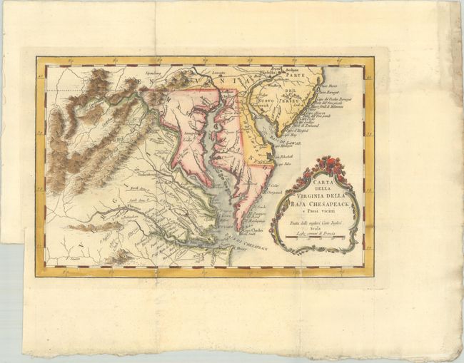
Lot 140
Subject: Colonial Mid-Atlantic United States
Bellin, Jacques Nicolas
Carta della Virginia della Baja Chesapeack, e Paesi Vicini, 1781
Size: 11.2 x 7.3 inches (28.4 x 18.5 cm)
Estimate: $240 - $300
Sold for: $220
Closed on 6/18/2025
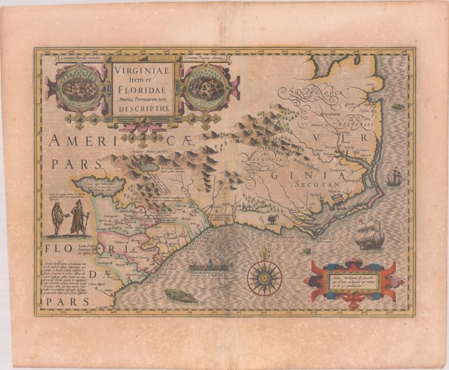
Lot 141
Subject: Colonial Southeastern United States
Hondius, Jodocus
Virginiae Item et Floridae Americae Provinciarum, Nova Descriptio, 1619
Size: 19.1 x 13.5 inches (48.5 x 34.3 cm)
Estimate: $1,400 - $1,700
A Seminal Map of the Southeast and Early American Cartography in Full Contemporary Color
166 lots
Page 1 of 4