Subject: Northern United States
Period: 1916 (dated)
Publication:
Color: Printed Color
Size:
45.8 x 16.5 inches
116.3 x 41.9 cm
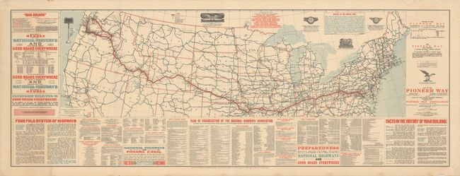
This scarce and elaborate production promoting the "Pioneer Way" was published by the National Highways Association under the direction of A.L. Westgard. It highlights a proposed highway route from Washington D.C. to Olympia, WA that would traverse "14 states, touching 6 state capitals and 107 counties, touching 65 county seats." Coupled with other highways drawn in blue, the map presents a potentially robust road network in the northern half of the country (a note at right states "this map shows tentative locations for part of a system"). Flanking the map are panels of related text including a list of the original board members and charter, the proposal for a “Four Fold System of Highways,” and a history of road building. The National Highways Association was instrumental in generating federal interest in and funding for highways, and maps like this played a key part in the Association's promotional strategy. We found no past sales records or institutional examples on OCLC.
References:
Condition: B+
Originally issued folding and now rolled with some light toning at left and faint dampstains at right. A couple of small edge tears confined to the margins have been closed on verso with archival tape.