Subject: Colonial New England & Mid-Atlantic United States
Period: 1690 (circa)
Publication:
Color: Hand Color
Size:
21.4 x 18.2 inches
54.4 x 46.2 cm
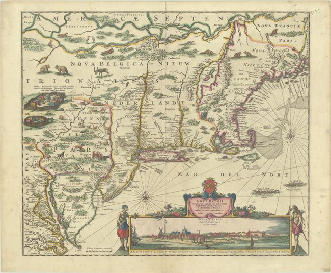
This is one of the most decorative colonial maps of the United States and the last in the Jansson/Visscher series. Geographically and stylistically, the map is derived from Visscher's map of circa 1655, which is nearly identical with Jansson's map, which in turn borrowed heavily from the Blaeu map of 1635, including some of its most glaring errors. It covers the region from Chesapeake Bay to Penobscot Bay and includes the placement of nearly every colonial settlement along the coastline and rivers. The land is fully engraved to show forests, mountains, rivers and lakes with most of the geography based on the work of Champlain. Lacus Irocoisiensis (Lake Champlain) remains radically misplaced to the east of the Connecticut River, the St. Lawrence River (also called the Grand River of New Netherland) and Ottawa River are intertwined, and the coast of New England is imperfectly mapped. The influence of the Dutch in the region over that of the English was also grossly misrepresented in this map, exemplified by the large lettering of Nova Belgica Nieuw Nederlandt compared with the diminutive lettering of Nova Anglia Nieuw Engelandt. This is the third state, revised to show Niew Castel alias Sandhoeck on the west side of the Delaware Bay, and Yermonton above Philadelphia. The Delaware River was completely redrawn to erase a connection with the Hudson River. An array of domestic animals have been added to the wild animals and Indian village scene.
The most important feature of the map is the superb view of New York below the title cartouche that was taken from the Visscher map. In this state, the title to this view acknowledges the English hold over the city with Nieuw Yorck, eertys Genaemt above the original title Nieuw Amsterdam op't Eylant Manhattans. This view is one of the earliest images of New York City showing the southern tip of Manhattan Island as a small settlement dominated by a Dutch fort and the buildings of the Dutch West India Company. This fascinating view is based on the Albertina drawing, discovered in the Albertina Collection of the Austrian National Library in 1991, and is believed to have been used to illustrate the text of Adriaen van der Donck's Remonstrance. The Albertina drawing depicts the struggling Dutch colony of New Amsterdam circa 1648, and was designed to substantiate Van der Donck's plea to the States-General for additional support for the colony. Although the buildings, structures, and layout are nearly identical in Visscher and Albertina views, Visscher beautified the appearance of the town to accomplish a very different goal: encouraging emigration to the new colony.
References: Burden #434; McCorkle #680.2; Tooley (Amer), p. 286, Campbell, Jansson-Visscher #9a.
Condition: A
A crisp impression with full contemporary color on a bright sheet with an archivally repaired centerfold separation at bottom and light soiling that is mostly confined to the blank margins.