Filtered by Category:United States(Show All Categories)
Showing results for:Auction 191
Catalog Archive
234 lots
Page 1 of 5
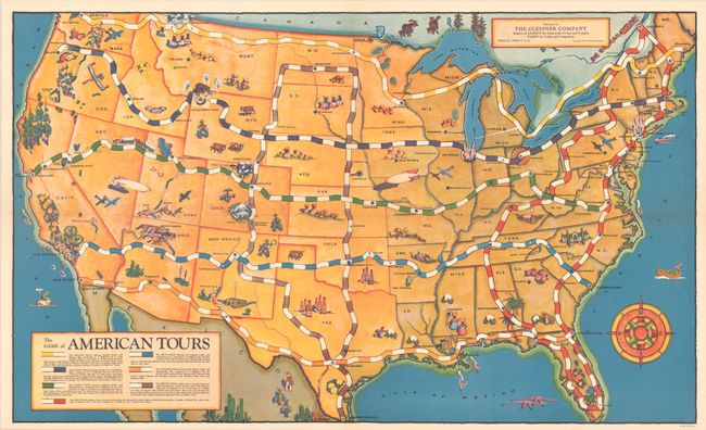
Auction 191, Lot 68
Subject: Cartographic Miscellany, Games, United States
The Game of American Tours, 1933
Size: 28.6 x 17.3 inches (72.6 x 43.9 cm)
Estimate: $400 - $475
Complete Depression-Era Map Board Game
Sold for: $200
Closed on 2/8/2023
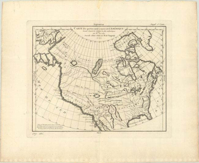
Auction 191, Lot 122
Subject: Colonial United States & Canada
Robert de Vaugondy, Didier
Carte des Parties Nord et Ouest de l'Amerique Dressee d'Apres les Relations les Plus Authentiques par M... en 1764, 1772
Size: 14.4 x 11.3 inches (36.6 x 28.7 cm)
Estimate: $220 - $250
Sold for: $160
Closed on 2/8/2023
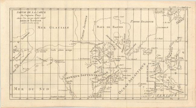
Auction 191, Lot 123
Subject: United States & Canada, Arctic
[Lot of 2] Partie de la Carte du Capitaine Cluny Auteur d'un Ouvrage Anglois Intitule American Traveller Publie a Londres en 1769 [and] Arctic Regions and British America, 1772-1853
Size: See Description
Estimate: $180 - $220
Sold for: $70
Closed on 2/8/2023
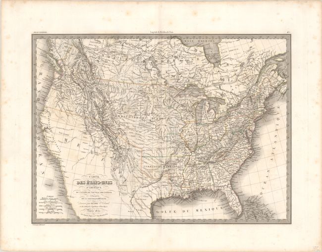
Auction 191, Lot 124
Subject: United States & Canada
Lapie, Alexander Emile & Pierre
Carte des Etats-Unis d'Amerique, du Canada, du Nouveau Brunswick et d'une Partie de la Nouvelle Bretagne, 1832
Size: 21.2 x 15.5 inches (53.8 x 39.4 cm)
Estimate: $275 - $350
Sold for: $200
Closed on 2/8/2023
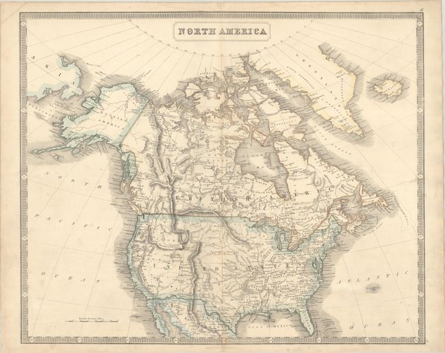
Auction 191, Lot 125
Subject: United States & Canada
Philip, George
North America, 1855
Size: 23.9 x 19.7 inches (60.7 x 50 cm)
Estimate: $160 - $190
Sold for: $210
Closed on 2/8/2023
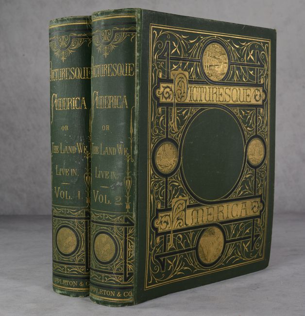
Auction 191, Lot 126
Subject: United States & Canada
Bryant, William C.
[2 Volumes] Picturesque America; or, the Land We Live In..., 1872-74
Size: 10.3 x 13.1 inches (26.2 x 33.3 cm)
Estimate: $550 - $700
Sold for: $400
Closed on 2/8/2023
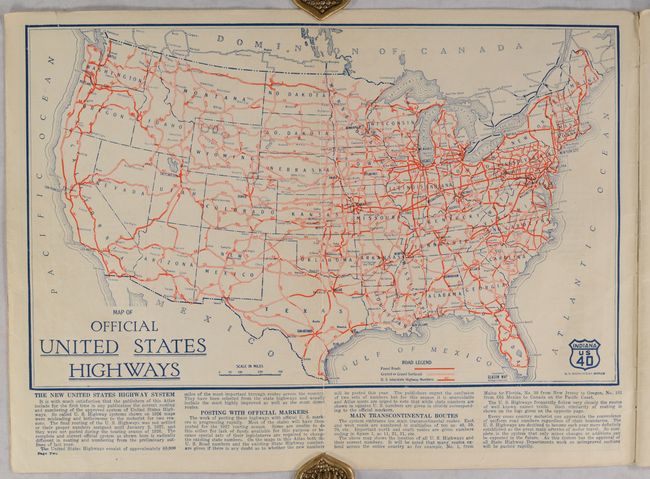
Auction 191, Lot 127
Subject: United States & Canada, Road Atlas
Clason Map Company
Clason's Touring Atlas of the United States with Road Maps of Every State and Ontario and Quebec, Canada, 1927
Size: 8.6 x 12 inches (21.8 x 30.5 cm)
Estimate: $150 - $180
Sold for: $110
Closed on 2/8/2023
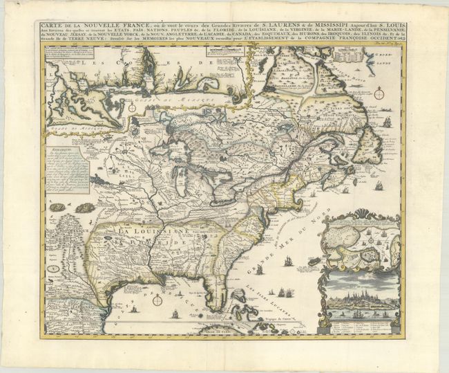
Auction 191, Lot 128
Subject: Colonial Eastern United States & Canada
Chatelain, Henry Abraham
Carte de la Nouvelle France, ou se Voit le Cours des Grandes Rivieres de S. Laurens & de Mississipi Aujour d'hui S. Louis, aux Environs des-quelles se Trouvent les Etats, Pais, Nations, Peuples &c. de la Floride..., 1720
Size: 19.1 x 16.6 inches (48.5 x 42.2 cm)
Estimate: $3,000 - $3,750
One of the Most Informative 18th Century Maps of the French Possessions in North America
Sold for: $3,000
Closed on 2/8/2023
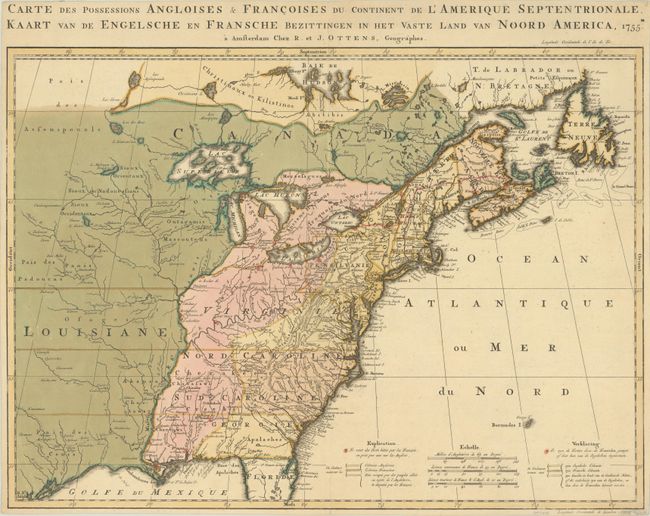
Auction 191, Lot 129
Subject: Colonial Eastern United States & Canada
Ottens, Reiner and Joshua
Carte des Possessions Angloises & Francoises du Continent de l'Amerique Septentrionale / Kaart van de Engelsche en Fransche Bezittingen in het Vaste Land van Noord America, 1755
Size: 22.4 x 16.3 inches (56.9 x 41.4 cm)
Estimate: $1,400 - $1,700
Dutch Version of an Important Map Showing Territorial Claims at the Outset of the French and Indian War
Sold for: $1,000
Closed on 2/8/2023
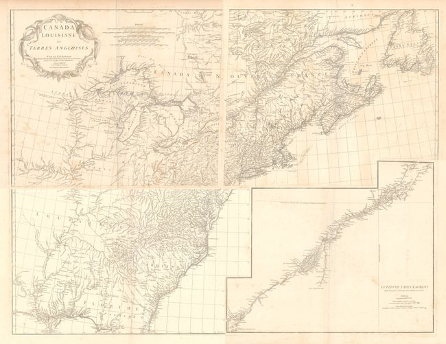
Auction 191, Lot 130
Subject: Colonial Eastern United States & Canada
Anville, Jean Baptiste Bourguignon d'
[On 4 Sheets] Canada Louisiane et Terres Angloises, 1755
Size: 22 x 18.8 inches (55.9 x 47.8 cm)
Estimate: $1,100 - $1,400
D'Anville's Spectacular Map of Eastern Seaboard
Sold for: $800
Closed on 2/8/2023
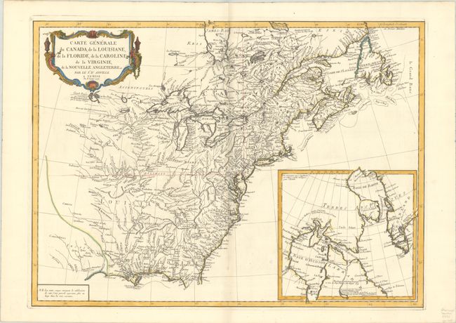
Auction 191, Lot 131
Subject: Colonial Eastern United States & Canada
D'Anville/Santini
Carte Generale du Canada, de la Louisiane, de la Floride, de la Caroline, de la Virginie, de la Nouvelle Angleterre etc. par le Sr. d'Anville, 1776
Size: 25.7 x 18.9 inches (65.3 x 48 cm)
Estimate: $475 - $600
Sold for: $350
Closed on 2/8/2023
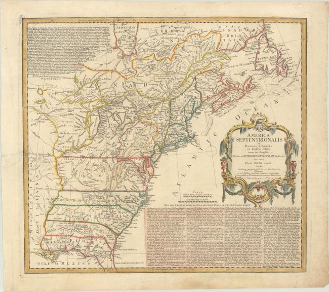
Auction 191, Lot 132
Subject: Colonial Eastern United States & Canada
Homann Heirs
America Septentrionalis a Domino d'Anville in Galliis Edita nunc in Anglia Coloniis in Interiorem Virginiam Deductis nec non Fluvii Ohio Cursu…, 1777
Size: 20 x 18 inches (50.8 x 45.7 cm)
Estimate: $550 - $700
Sold for: $650
Closed on 2/8/2023
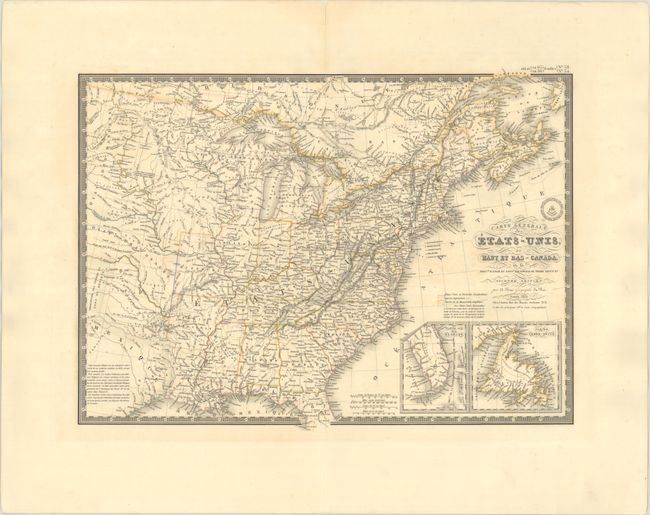
Auction 191, Lot 133
Subject: Eastern United States & Canada
Brue, Adrien Hubert
Carte Generale des Etats-Unis, du Haut et Bas-Canada, de la Nouvle. Ecosse du Nouvau. Brunswick de Terre Neuve &a. Seconde Edition, 1832
Size: 20.3 x 14.8 inches (51.6 x 37.6 cm)
Estimate: $230 - $275
Sold for: $170
Closed on 2/8/2023
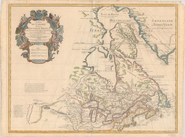
Auction 191, Lot 134
Subject: Colonial Northeastern United States & Canada, Great Lakes
Delisle, Guillaume
Carte du Canada ou de la Nouvelle France et des Decouvertes qui y ont ete Faites Dressee sur Plusieurs Observations et sur un Grand Nombre de Relations Imprimees ou Manuscrites..., 1703
Size: 25.6 x 19.6 inches (65 x 49.8 cm)
Estimate: $1,900 - $2,200
Delisle's Seminal Map of Canada and the Great Lakes
Sold for: $1,400
Closed on 2/8/2023
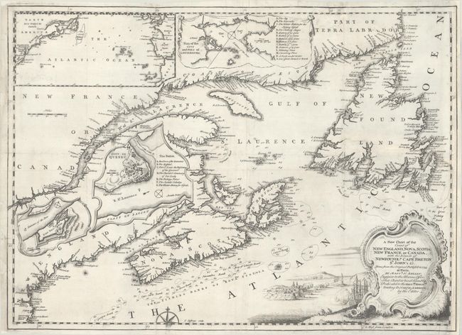
Auction 191, Lot 135
Subject: Colonial Northeastern United States & Canada
Jefferys, Thomas
A New Chart of the Coast of New England, Nova Scotia, New France or Canada, with the Islands of Newfoundld. Cape Breton St. John's &c..., 1746
Size: 18.6 x 13.5 inches (47.2 x 34.3 cm)
Estimate: $350 - $425
Sold for: $475
Closed on 2/8/2023
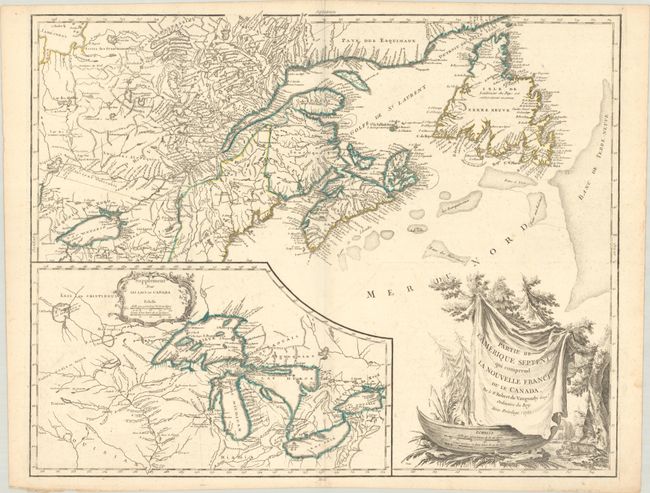
Auction 191, Lot 136
Subject: Colonial Northeastern United States & Canada, Great Lakes
Robert de Vaugondy, Didier
Partie de l'Amerique Septent? qui Comprend la Nouvelle France ou le Canada, 1755
Size: 23.8 x 19.1 inches (60.5 x 48.5 cm)
Estimate: $550 - $700
Sold for: $400
Closed on 2/8/2023
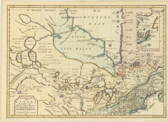
Auction 191, Lot 137
Subject: Colonial Northeastern United States & Canada
Tirion, Isaac
Nieuwe Kaart van Kanada, de Landen aan de Hudsons-Baay en de Noordwestelyke Deelen van Noord-Amerika, 1769
Size: 17.4 x 12.3 inches (44.2 x 31.2 cm)
Estimate: $275 - $350
Sold for: $325
Closed on 2/8/2023
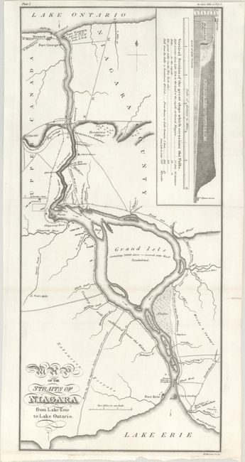
Auction 191, Lot 138
Subject: Niagara Falls, New York & Canada
Map of the Straits of Niagara from Lake Erie to Lake Ontario, 1818
Size: 6.9 x 15.1 inches (17.5 x 38.4 cm)
Estimate: $250 - $325
Sold for: $350
Closed on 2/8/2023
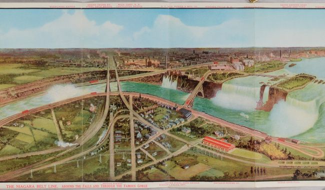
Auction 191, Lot 139
Subject: Niagara Falls, New York & Canada
Railroad Companies, (Various)
The Niagara Belt Line. Around the Falls And Through the Famous Gorge [and] One Way from Buffalo, Tonawanda, Niagara Falls and Lewiston to Toronto. By The “Niagara River Route.” [in] New York Central Lines "Travel Series No. 9" Niagara Falls..., 1912
Size: 4.3 x 8.5 inches (10.9 x 21.6 cm)
Estimate: $160 - $190
Sold for: $120
Closed on 2/8/2023
Auction 191, Lot 140
Subject: Central United States & Canada
U.S. Government
[19 Maps in Report] Boundary Between the United States and Great Britain. Message from the President of the United States..., 1838
Size: 5.6 x 8.9 inches (14.2 x 22.6 cm)
Estimate: $200 - $230
Sold for: $170
Closed on 2/8/2023
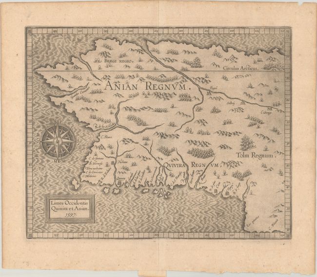
Auction 191, Lot 141
Subject: Alaska & Western Canada
Wytfliet, Cornelis
Limes Occidentis Quivira et Anian, 1597
Size: 11.5 x 9.3 inches (29.2 x 23.6 cm)
Estimate: $1,900 - $2,200
Early and Imaginary Map of Alaska and the Northwest Passage
Sold for: $1,400
Closed on 2/8/2023
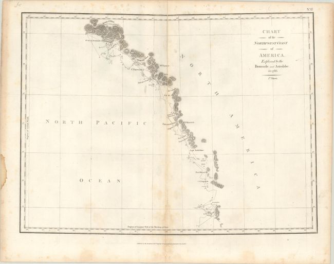
Auction 191, Lot 142
Subject: Western United States & Canada
La Perouse, Comte Jean F. Galoup, de
[On 3 Sheets] Chart of the North West Coast of America. Explored by the Boussole, and Astrolabe in 1786, 1798
Size: 19.3 x 14.3 inches (49 x 36.3 cm)
Estimate: $500 - $650
Sold for: $250
Closed on 2/8/2023
Auction 191, Lot 143
Subject: United States
Warner, Benjamin
United States of America Corrected & Improved from the Best Authorities, 1820
Size: 25.1 x 16.5 inches (63.8 x 41.9 cm)
Estimate: $800 - $950
Sold for: $1,000
Closed on 2/8/2023
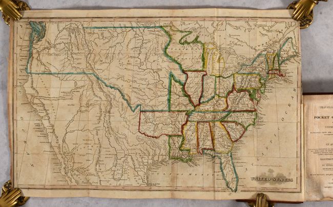
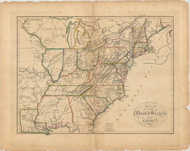
Auction 191, Lot 144
Subject: United States
Morse, Jedidiah (Rev.)
[Map in Book] United States [in] The Traveller's Guide; or Pocket Gazetteer of the United States; Extracted from the Latest Edition of Morse's Universal Gazetteer..., 1826
Size: 16.8 x 10 inches (42.7 x 25.4 cm)
Estimate: $300 - $375
Sold for: $650
Closed on 2/8/2023
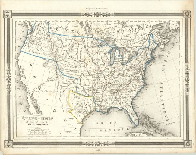
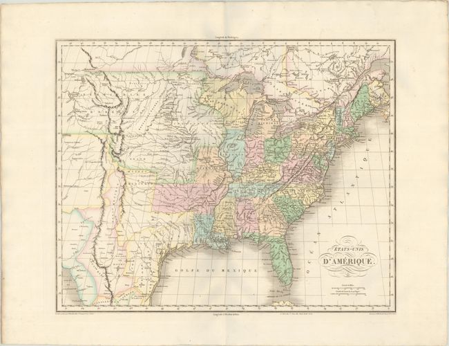
Auction 191, Lot 145
Subject: United States, Texas
Duvotenay, Thunot
Etats-Unis, 1846
Size: 12.3 x 9.1 inches (31.2 x 23.1 cm)
Estimate: $160 - $190
Sold for: $140
Closed on 2/8/2023
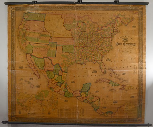
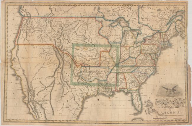
Auction 191, Lot 146
Subject: United States
Gaston & Johnson
A New Map of Our Country, Prospective and Present Compiled from Government Surveys and Other Reliable Sources, 1856
Size: 63.4 x 55.5 inches (161 x 141 cm)
Estimate: $1,400 - $1,700
Scarce Wall Map Documenting Westward Expansion
Sold for: $700
Closed on 2/8/2023
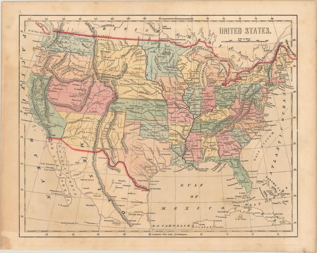
Auction 191, Lot 147
Subject: United States
Morse, Charles W.
United States, 1856
Size: 14.8 x 11.9 inches (37.6 x 30.2 cm)
Estimate: $190 - $230
Sold for: $210
Closed on 2/8/2023
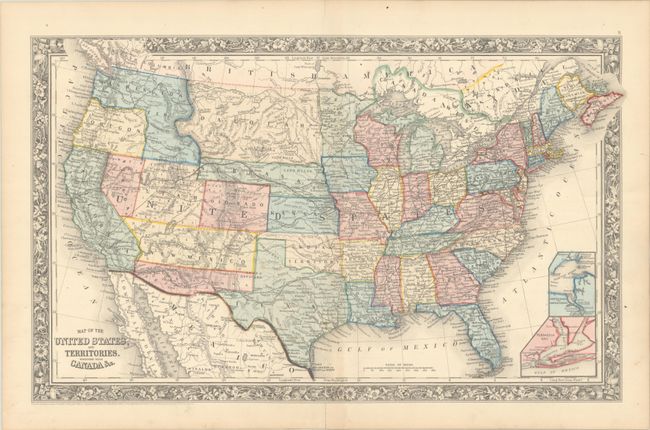
Auction 191, Lot 148
Subject: United States
Mitchell, Samuel Augustus
Map of the United States, and Territories. Together with Canada &c., 1860
Size: 21.5 x 13.3 inches (54.6 x 33.8 cm)
Estimate: $220 - $250
Sold for: $600
Closed on 2/8/2023
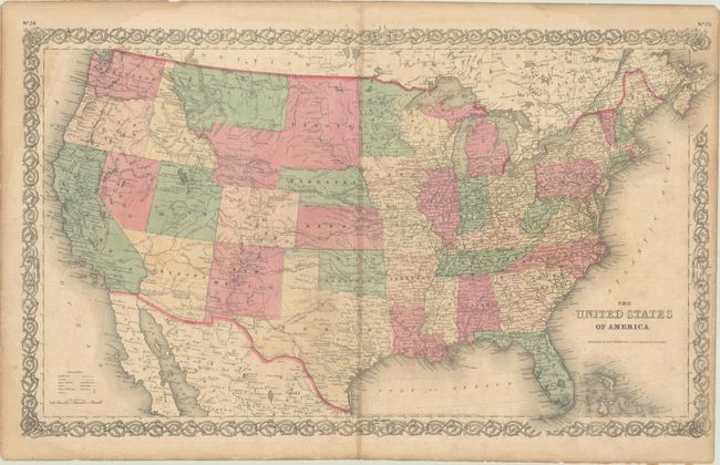
Auction 191, Lot 149
Subject: United States
Colton, Joseph Hutchins
The United States of America, 1866
Size: 26.4 x 15.8 inches (67.1 x 40.1 cm)
Estimate: $250 - $325
Sold for: $180
Closed on 2/8/2023
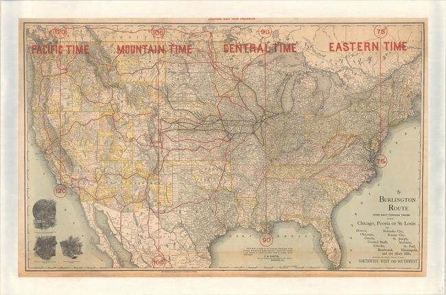
Auction 191, Lot 150
Subject: United States, Railroads
Railroad Companies, (Various)
The Burlington Route Runs Daily Through Trains Between Chicago, Peoria, or St. Louis... , 1892
Size: 44.1 x 27.6 inches (112 x 70.1 cm)
Estimate: $220 - $250
Sold for: $150
Closed on 2/8/2023
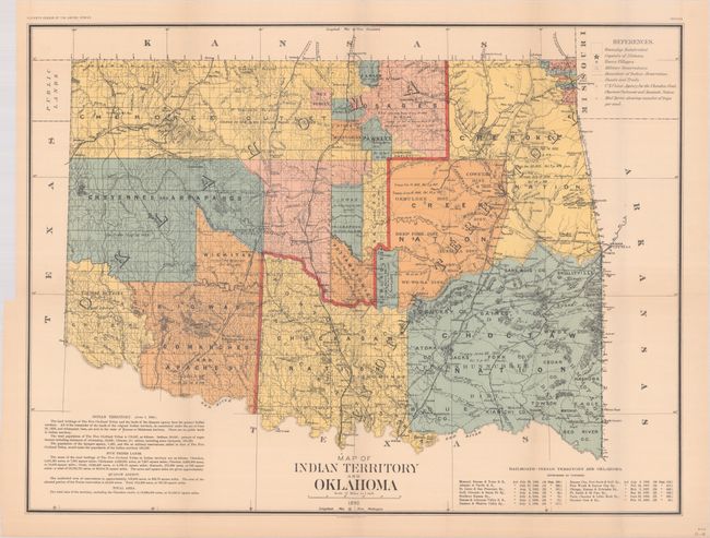
Auction 191, Lot 151
Subject: United States, Oklahoma
U.S. Department of Interior
[3 Maps with Report] Report on Indians Taxed and Indians Not Taxed in the United States (Except Alaska) at the Eleventh Census: 1890, 1894
Size: 29.7 x 22.3 inches (75.4 x 56.6 cm)
Estimate: $700 - $850
Sold for: $800
Closed on 2/8/2023
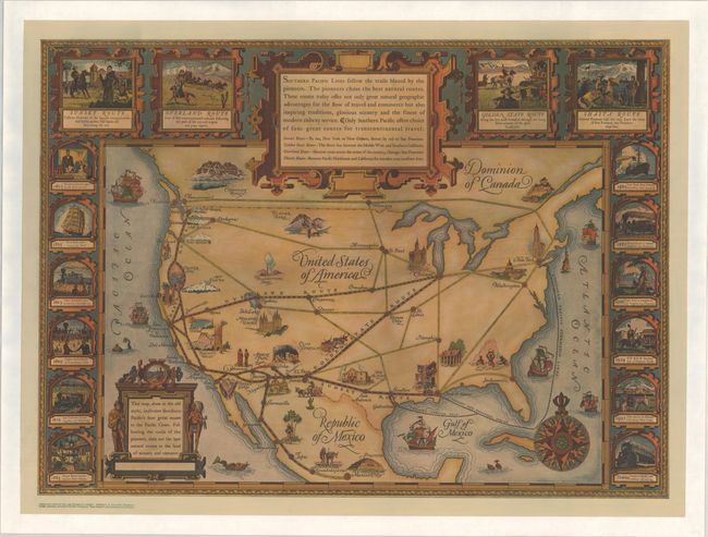
Auction 191, Lot 152
Subject: United States, Railroads
Southern Pacific Rail Road Co.
Southern Pacific Lines Follow the Trails Blazed by the Pioneers..., 1928
Size: 32 x 23.3 inches (81.3 x 59.2 cm)
Estimate: $275 - $350
Sold for: $190
Closed on 2/8/2023
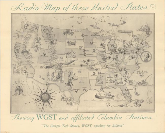
Auction 191, Lot 153
Subject: United States
Radio Map of These United States Showing WGST and Affiliated Columbia Stations, 1930
Size: 15 x 10.4 inches (38.1 x 26.4 cm)
Estimate: $200 - $230
Unsold
Closed on 2/8/2023
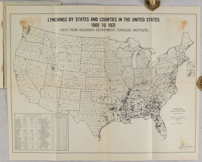
Auction 191, Lot 154
Subject: United States
Lynchings by States and Counties in the United States 1900 to 1931 (Data from Research Department, Tuskegee Institute) [in] Lynchings and What They Mean, 1931
Size: 19.3 x 14.5 inches (49 x 36.8 cm)
Estimate: $250 - $325
Poignant Map of the United States Documenting Lynchings
Sold for: $1,100
Closed on 2/8/2023
Auction 191, Lot 155
Subject: United States, Atlases
Harper Bros.
Berta and Elmer Hader's Picture Book of the States, 1932
Size: 12.4 x 9.3 inches (31.5 x 23.6 cm)
Estimate: $400 - $500
Sold for: $325
Closed on 2/8/2023
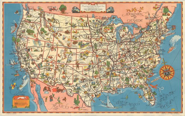
Auction 191, Lot 156
Subject: United States
A Good-Natured Map of the United States Setting Forth the Services of the Greyhound Lines and a Few Principal Connecting Bus Lines, 1939
Size: 18.5 x 11.5 inches (47 x 29.2 cm)
Estimate: $140 - $170
Sold for: $90
Closed on 2/8/2023
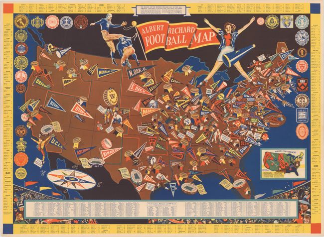
Auction 191, Lot 157
Subject: United States
Albert Richard Football Map, 1940
Size: 25.6 x 18.6 inches (65 x 47.2 cm)
Estimate: $400 - $500
A WWII-Era Map Celebrating College Football
Sold for: $500
Closed on 2/8/2023
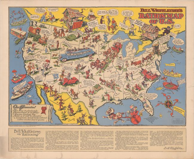
Auction 191, Lot 158
Subject: United States, World War II
[Lot of 2] Bill Whiffletree's Ration Map of U.S. [and] Bill Whiffletree's Bootleggers' Map of the United States, 1944
Size: 30.1 x 20.2 inches (76.5 x 51.3 cm)
Estimate: $3,000 - $4,000
Matching Pair Featuring the Extremely Rare "Ration Map"
Sold for: $2,000
Closed on 2/8/2023
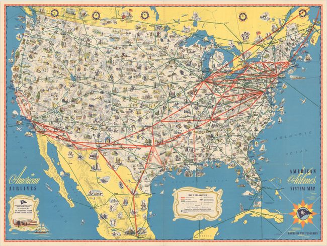
Auction 191, Lot 159
Subject: United States, Aviation
American Airlines System Map - Route of the Flagships, 1945
Size: 31.3 x 23.3 inches (79.5 x 59.2 cm)
Estimate: $100 - $130
NO RESERVE
Sold for: $55
Closed on 2/8/2023
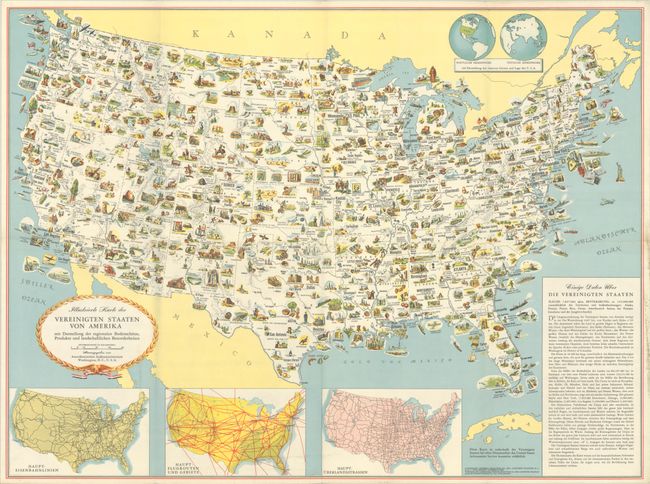
Auction 191, Lot 160
Subject: United States
Illustrierte Karte der Vereinigten Staaten von Amerika mit Darstellung der Regionalen Bodenschatze, Produkte und Landschaftlichen Besonderheiten, 1952
Size: 31.3 x 23.2 inches (79.5 x 58.9 cm)
Estimate: $140 - $170
Sold for: $100
Closed on 2/8/2023
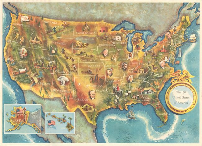
Auction 191, Lot 161
Subject: United States
The 50 United States of America, 1960
Size: 25 x 17.9 inches (63.5 x 45.5 cm)
Estimate: $200 - $230
Unsold
Closed on 2/8/2023
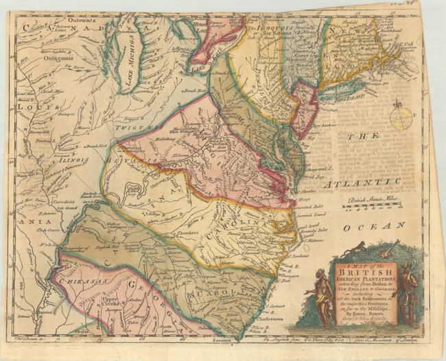
Auction 191, Lot 162
Subject: Colonial Eastern United States
Bowen, Emanuel
A Map of the British American Plantations Extending from Boston in New England to Georgia; Including All the Back Settlements in the Respective Provinces, as Far as the Mississipi, 1754
Size: 11 x 8.8 inches (27.9 x 22.4 cm)
Estimate: $350 - $425
Sold for: $550
Closed on 2/8/2023
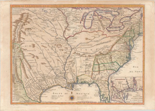
Auction 191, Lot 163
Subject: Colonial Eastern United States, Louisiana Territory
Delisle/Dezauche
Carte de la Louisiane et du Cours du Mississipi avec les Colonies Anglaises, 1782
Size: 25.5 x 19.2 inches (64.8 x 48.8 cm)
Estimate: $1,200 - $1,500
Dezauche Edition of Delisle's Influential Map of the Louisiana Territory
Sold for: $1,200
Closed on 2/8/2023
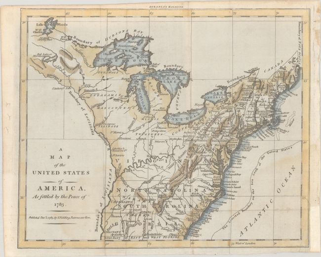
Auction 191, Lot 164
Subject: Eastern United States
Fielding, John
A Map of the United States of America, as Settled by the Peace of 1783, 1783
Size: 9.9 x 8.1 inches (25.1 x 20.6 cm)
Estimate: $500 - $650
Rare Map of the Young United States Published Right After the Revolutionary War
Sold for: $475
Closed on 2/8/2023
Auction 191, Lot 165
Subject: Eastern United States
Klockhoff, H.
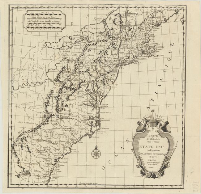
Carte Generale des Treize Etats Unis Independants de l'Amerique Septetrionale d'Apres, 1783
Size: 15.4 x 16.1 inches (39.1 x 40.9 cm)
Estimate: $400 - $475
Early Reference to United States
Sold for: $325
Closed on 2/8/2023
Auction 191, Lot 166
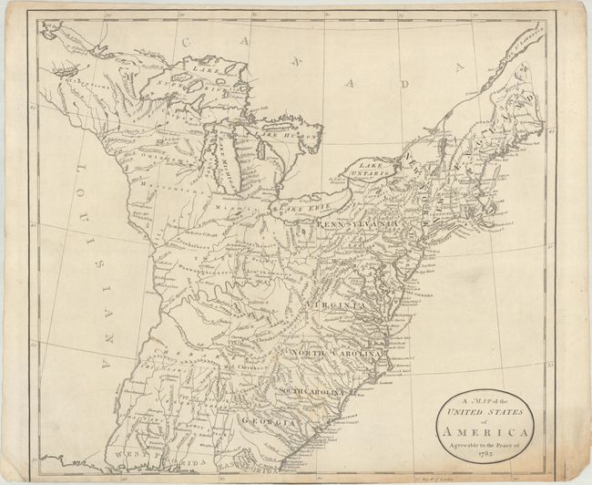
Subject: Eastern United States
Guthrie, William
A Map of the United States of America Agreeable to the Peace of 1783, 1786
Size: 15.4 x 13.9 inches (39.1 x 35.3 cm)
Estimate: $350 - $425
Sold for: $250
Closed on 2/8/2023
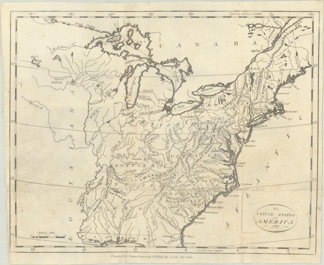
Auction 191, Lot 167
Subject: Eastern United States
Payne, John
The United States of America, 1800
Size: 12.1 x 9.6 inches (30.7 x 24.4 cm)
Estimate: $350 - $425
Unsold
Closed on 2/8/2023
Auction 191, Lot 168
Subject: Eastern United States
[Lot of 2] United States [and] United States, 1804-32
Size: See Description
Estimate: $160 - $190
NO RESERVE
Sold for: $130
Closed on 2/8/2023
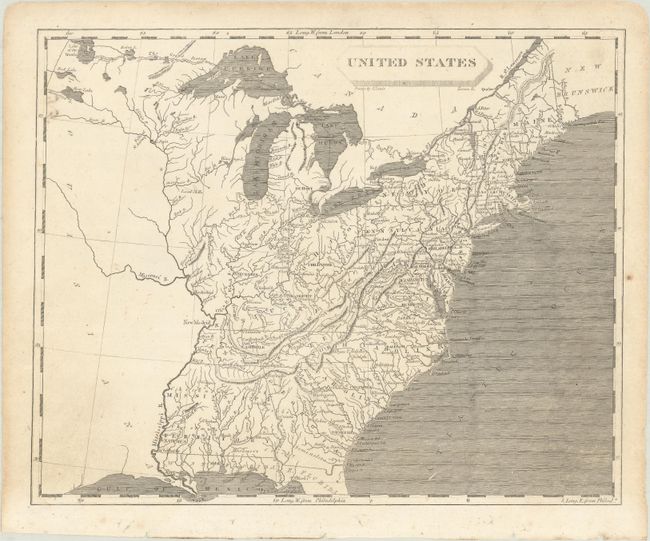
Auction 191, Lot 169
Subject: Eastern United States
Carey, Mathew
Map of the United States of America, 1814
Size: 17.3 x 13.2 inches (43.9 x 33.5 cm)
Estimate: $450 - $550
Sold for: $475
Closed on 2/8/2023
Auction 191, Lot 170
Subject: Eastern United States
Buchon, Jean Alexandre
Etats-Unis d'Amerique, 1825
Size: 20.8 x 16.7 inches (52.8 x 42.4 cm)
Estimate: $375 - $450
Sold for: $275
Closed on 2/8/2023
234 lots
Page 1 of 5