Subject: Niagara Falls, New York & Canada
Period: 1818 (published)
Publication: A Full and Correct Account of the Military Occurrences of the Late War...
Color: Black & White
Size:
6.9 x 15.1 inches
17.5 x 38.4 cm
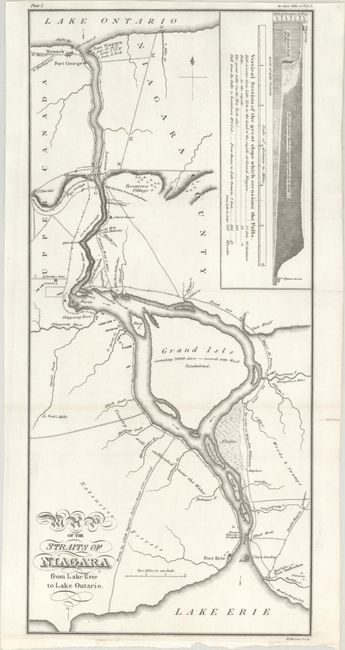
This War of 1812 map appeared as the frontispiece in William James' A Full and Correct Account of the Military Occurrences of the Late War. The map centers roughly on Grand Isle and spans from Lake Ontario to Lake Erie. It identifies Fort Niagara, Fort George, Fort Erie, Tuscarora Village, and Buffaloe or New Amsterdam and locates sites of battles, including Lundy's Lane and Cook's Mills. Roads are delineated, among them Road cut by Major M. Porter in 1802 by order of Brig. Gen. Wilkinson and Route by which Captain Dobb's Boats were carried. An inset shows a cross-section of the Falls. During the war, there was much conflict around the Niagara frontier as the British and Americans vied for control of the Great Lakes and St. Lawrence River. This map depicts this theater of the war in excellent detail. Engraved by H. Mutlow.
References: Phillips (Maps) p. 549.
Condition: A
Issued folding on a bright sheet with a couple of small fold separations confined to the right blank margin.