Catalog Archive
Auction 191, Lot 154

Poignant Map of the United States Documenting Lynchings

"Lynchings by States and Counties in the United States 1900 to 1931 (Data from Research Department, Tuskegee Institute) [in] Lynchings and What They Mean",

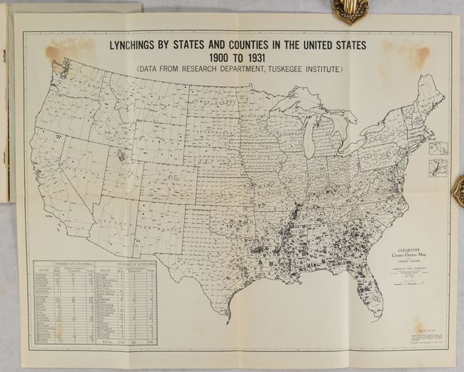
Subject: United States

Period: 1931 (published)

Publication:

Color: Black & White

Size:
19.3 x 14.5 inches
49 x 36.8 cm
Download High Resolution Image
(or just click on image to launch the Zoom viewer)

This poignant map of the United States by the American Map Company was based on ongoing research by sociologist Monroe Work at the Tuskegee Institute to document all cases of lynching since 1900. While the map predictably shows the largest number of lynchings in the states of the Old Confederacy, more surprising is that only seven states are shown without a documented lynching. A table in the corner of the map shows state by state comparisons. In a 2021 article on black cartography Derek H. Alderman called this a “now iconic map” and described its significance (click here to read the article.)

The map is still bound in the 76-page report by the Southern Commission on the Study of Lynchings. The commission, which included Monroe Work, was created to focus attention on lynchings after an increase in 1930. The report itself is a remarkably sober and unemotional description of the distressing problem and its remedies. Many efforts were made in Congress to outlaw the practice at the federal level, but all failed until the passage of an act in 2022 making lynching a federal hate crime. Gray paper wrappers.

See also lot 814 for an update to the report published in 1936.

References:

Condition: B+

The folding map has some light staining in the corners from where it was glued to the rear wrapper. Text is clean, bright and fine. Wrappers have minor wear.

Estimate: $250 - $325

Sold for: $1,100

Closed on 2/8/2023

Archived