Advanced Search
Filtered by Category:Canada(Show All Categories)
Showing results for:Advanced search criteria below
Title
Word or word-fragment will be found anywhere within title, e.g. terr finds Terra, Terra Incognita, Territory, etc.
Geography
Word or word-fragment will be found anywhere within geography/subject, e.g. africa finds South Africa, African, etc.
Creator
Word or word-fragment will be found anywhere within creator's name(s).
Description
Word or word-fragment will be found anywhere within the lot description. Search will return exact matches only.
Period
Enter full year or year-fragment. 17 finds all items from the 1700s, 186 finds all from the 1860s.
Low Estimate Range
Find lots with low estimate equal to range selected.
Condition
Select condition to include in search.
Auction Date Range
Limits lots to a specific year or range of years (valid entries are 1999-present).
Catalog Archive
190 lots
Page 1 of 4
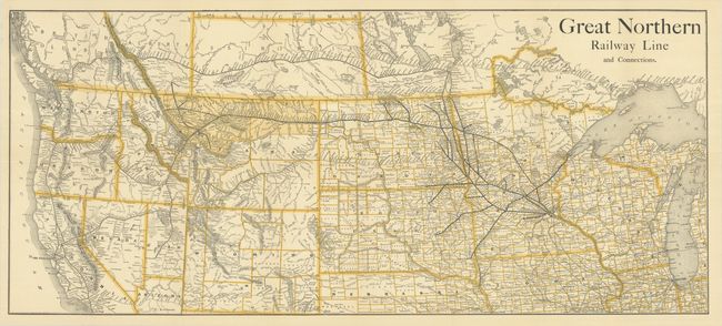
Auction 208, Lot 137
Subject: Western United States & Canada, Railroads
Railroad Companies, (Various)
Great Northern Railway Line and Connections, 1890
Size: 35.6 x 15.6 inches (90.4 x 39.6 cm)
Estimate: $250 - $325
Scarce Railroad Map with Bizarre Depictions of Montana and Wyoming. Colorado Is Off the Map!
Sold for: $180
Closed on 4/22/2026
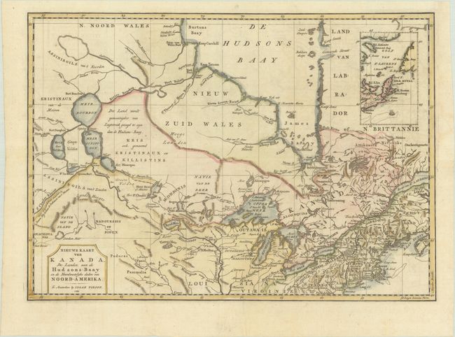
Auction 207, Lot 126
Subject: Colonial Northeastern United States & Canada
Tirion, Isaac
Nieuwe Kaart van Kanada, de Landen aan de Hudsons-Baay en de Noordwestelyke Deelen van Noord-Amerika, 1769
Size: 17.4 x 12.3 inches (44.2 x 31.2 cm)
Estimate: $350 - $425
Unsold
Closed on 2/11/2026
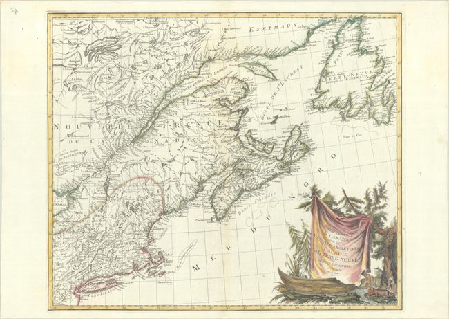
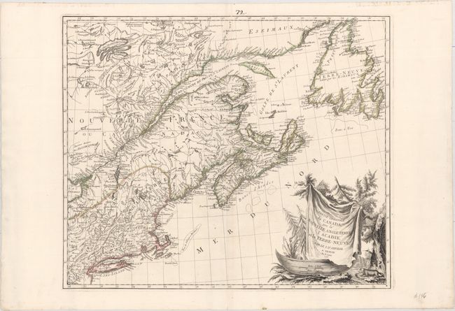
Auction 207, Lot 127
Subject: Colonial Northeastern United States & Canada
D'Anville/Santini
Partie Orientale du Canada, avec la Nouvelle Angleterre, l'Acadie, et la Terre-Neuve, 1776
Size: 22.8 x 19.1 inches (57.9 x 48.5 cm)
Estimate: $475 - $600
Sold for: $500
Closed on 2/11/2026
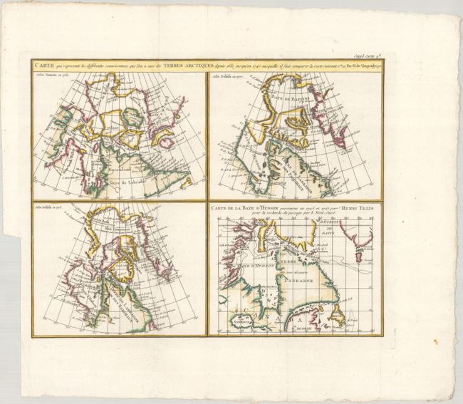
Auction 206, Lot 100
Subject: Eastern Canada
Robert de Vaugondy/Diderot
Carte qui Represente les Differentes Connoissances que l'on a eues des Terres Arctiques Depuis 1650 Jusqu'en 1747..., 1773
Size: 15.1 x 11.9 inches (38.4 x 30.2 cm)
Estimate: $140 - $170
Sold for: $70
Closed on 11/12/2025

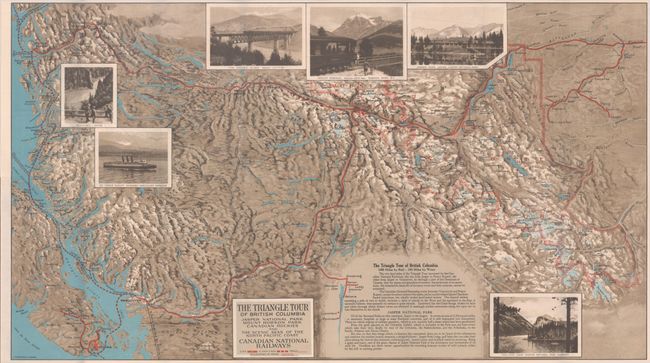
Auction 205, Lot 123
Subject: Northwestern United States & Canada
Railroad Companies, (Various)
The Triangle Tour of British Columbia - Jasper National Park Mount Robson Park Canadian Rockies and the Scenic Seas of the North Pacific Coast [on verso] Alaska and the Yukon, 1929
Size: 29.8 x 16.8 inches (75.7 x 42.7 cm)
Estimate: $150 - $180
NO RESERVE
Sold for: $46
Closed on 9/10/2025
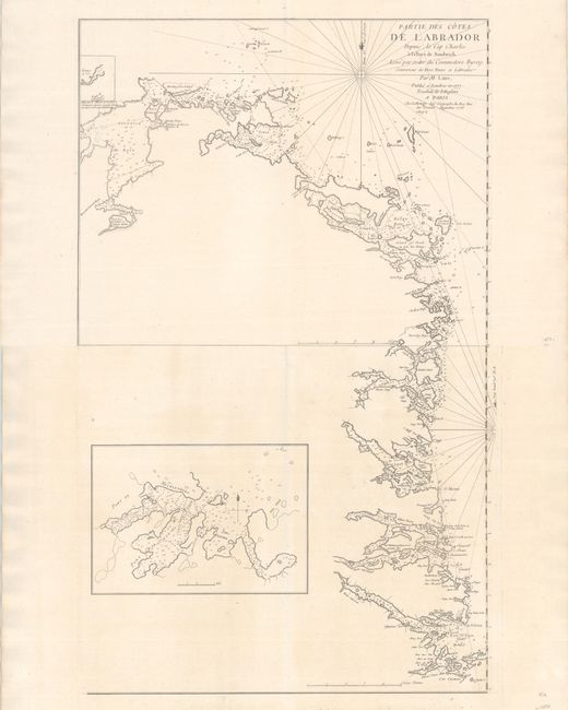
Auction 203, Lot 78
Subject: Labrador, Canada
Le Rouge, George Louis
[On 2 Sheets] Partie des Cotes de Labrador Depuis le Cap Charles a la Baye de Sandwich. Leve par Ordre du Commodore Byron..., 1777
Size: 21.3 x 17 inches (54.1 x 43.2 cm)
Estimate: $550 - $700
Sold for: $200
Closed on 4/23/2025
Auction 203, Lot 104
Subject: Northwestern United States & Canada
Railroad Companies, (Various)
The Triangle Tour of British Columbia - Jasper National Park Mount Robson Park Canadian Rockies and the Scenic Seas of the North Pacific Coast [on verso] Alaska and the Yukon, 1929
Size: 29.8 x 16.8 inches (75.7 x 42.7 cm)
Estimate: $150 - $180
NO RESERVE
Unsold
Closed on 4/23/2025
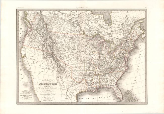
Auction 201, Lot 104
Subject: United States & Canada
Lapie, Alexander Emile & Pierre
Carte des Etats-Unis d'Amerique, du Canada, du Nouveau Brunswick et d'une Partie de la Nouvelle Bretagne, 1832
Size: 21.3 x 15.5 inches (54.1 x 39.4 cm)
Estimate: $300 - $375
Sold for: $175
Closed on 11/20/2024
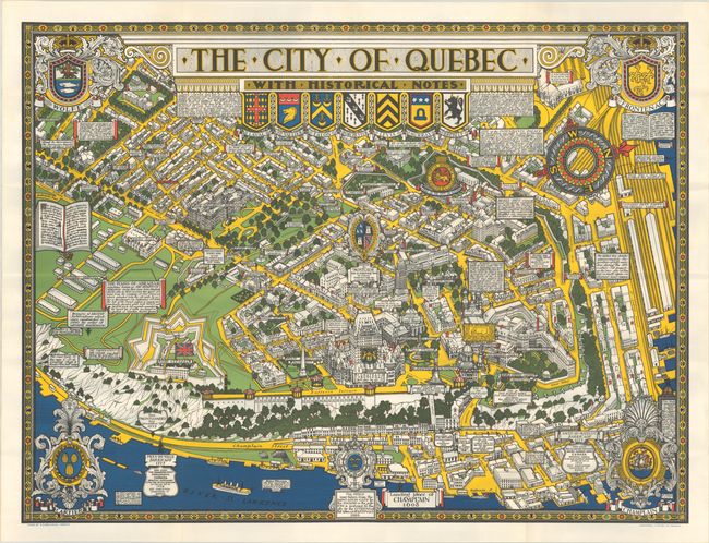
Auction 199, Lot 95
Subject: Quebec City, Canada
The City of Quebec with Historical Notes, 1932
Size: 33.4 x 25 inches (84.8 x 63.5 cm)
Estimate: $200 - $230
Sold for: $170
Closed on 9/11/2024
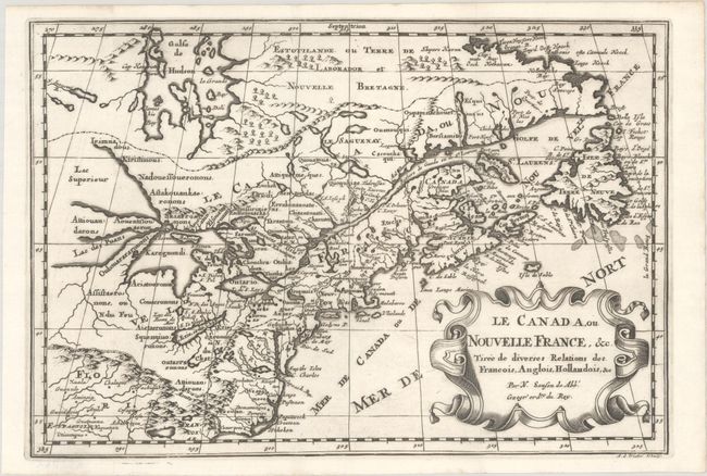
Auction 197, Lot 96
Subject: Colonial Eastern United States & Canada, Great Lakes
Sanson, Nicolas
Le Canada, ou Nouvelle France, &c. Tiree de Diverses Relations des Francois, Anglois, Hollandois, &c, 1700
Size: 11.9 x 8.1 inches (30.2 x 20.6 cm)
Estimate: $475 - $600
Small Version of a Keystone Map for Great Lakes Collections
Sold for: $375
Closed on 4/24/2024

Auction 196, Lot 113
Subject: Quebec, Canada
Turner, Stanley
[Lot of 2] Carte de Vacances Brading des Regions de Montreal et des Laurentides [and] Carte de Vacances Brading du Bas St. Laurent et des Cantons de l'Est, 1948
Size: 16.8 x 22.1 inches (42.7 x 56.1 cm)
Estimate: $475 - $600
Sold for: $350
Closed on 2/7/2024
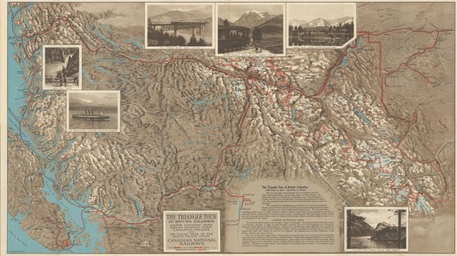
Auction 196, Lot 129
Subject: Alaska & British Columbia
Railroad Companies, (Various)
The Triangle Tour of British Columbia - Jasper National Park Mount Robson Park Canadian Rockies and the Scenic Seas of the North Pacific Coast [on verso] Alaska and the Yukon, 1929
Size: 29.8 x 16.8 inches (75.7 x 42.7 cm)
Estimate: $160 - $190
Sold for: $120
Closed on 2/7/2024
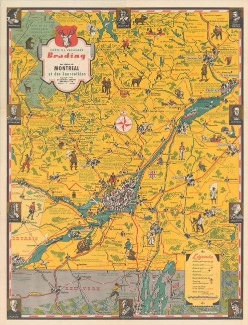
Auction 194, Lot 99
Subject: Quebec, Canada
Turner, Stanley
[Lot of 2] Carte de Vacances Brading des Regions de Montreal et des Laurentides [and] Carte de Vacances Brading du Bas St. Laurent et des Cantons de l'Est, 1948
Size: 16.8 x 22.1 inches (42.7 x 56.1 cm)
Estimate: $550 - $700
Unsold
Closed on 9/13/2023
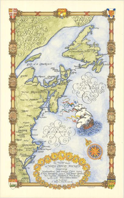
Auction 194, Lot 113
Subject: Northeastern United States & Canada
The "New" Lands of North Eastern America. Comprising Newfoundland, New Scotland (Nova Scotia), & New Brunswick: Parts of New France (Quebec), New England, New York & New Jersey..., 1960
Size: 13.3 x 22.2 inches (33.8 x 56.4 cm)
Estimate: $500 - $650
Rare Hand Colored Pictorial Map of New England and Eastern Canada, from the Estate of the Artist
Sold for: $300
Closed on 9/13/2023
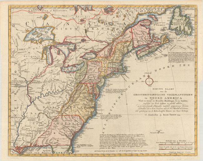
Auction 192, Lot 125
Subject: Colonial Eastern United States & Canada
Tirion, Isaac
Nieuwe Kaart van de Grootbrittannische Volkplantingen in Noord America waar in Tevens de Fransche Bezittingen en de Landen, Tusschen die Beide Volken in Geschil Staande..., 1755
Size: 17.9 x 14.5 inches (45.5 x 36.8 cm)
Estimate: $600 - $750
Sold for: $475
Closed on 4/26/2023
Auction 191, Lot 112
Subject: Eastern Canada & Greenland
Bonne, Rigobert
Partie de l'Amerique Septentrionale, qui Comprend le Canada, la Louisiane, le Labrador, le Groenland, la Nouvelle Angleterre, la Floride &c..., 1771
Size: 17 x 11.8 inches (43.2 x 30 cm)
Estimate: $160 - $190
Sold for: $120
Closed on 2/8/2023
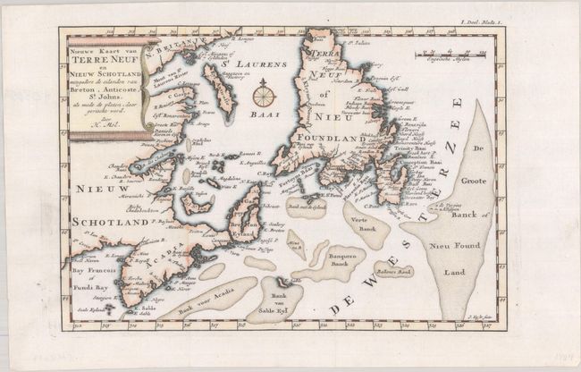
Auction 190, Lot 86
Subject: Eastern Canada
Moll, Herman
Nieuwe Kaart van Terre Neuf en Nieuw Schotland Mitsgaaders de Eilanden van Breton, Anticoste, St. Johns, als mede de Platen, daar Gevischt Word, 1721
Size: 9.9 x 6.8 inches (25.1 x 17.3 cm)
Estimate: $275 - $350
Sold for: $200
Closed on 11/16/2022
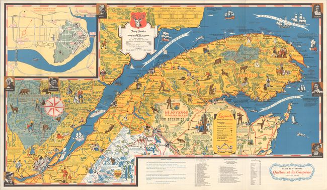
Auction 190, Lot 96
Subject: Quebec, Canada
Carte de Vacances Quebec et la Gaspesie Holiday Guide, 1959
Size: 31.2 x 17.9 inches (79.2 x 45.5 cm)
Estimate: $220 - $250
Sold for: $160
Closed on 11/16/2022
Auction 186, Lot 121
Subject: Canada
Canada, 1950
Size: 25.2 x 20.5 inches (64 x 52.1 cm)
Estimate: $140 - $170
Sold for: $80
Closed on 2/9/2022
Auction 186, Lot 145
Subject: Colonial Northeastern United States & Canada
Chatelain, Henry Abraham
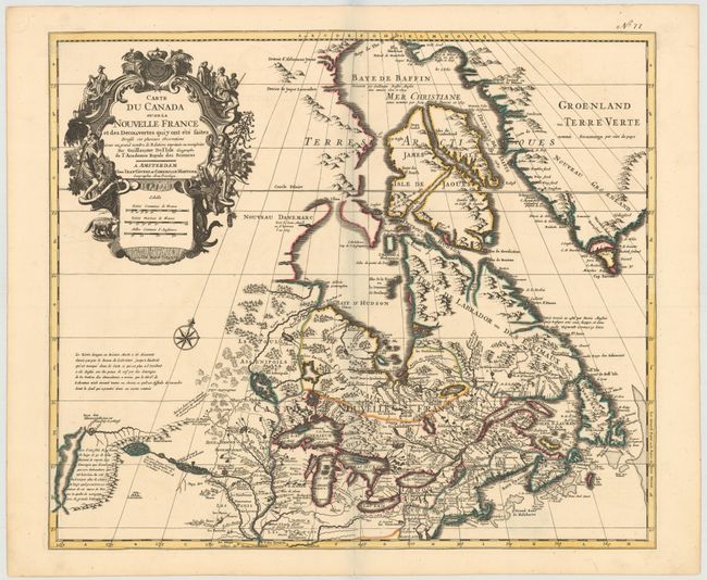
Carte du Canada ou de la Nouvelle France, & des Decouvertes qui y ont ete Faites, Dressee sur les Observations les Plus Nouvelles, & sur Divers Memoires tant Manuscrits qu' Imprimez, 1720
Size: 20.3 x 15.9 inches (51.6 x 40.4 cm)
Estimate: $600 - $750
Sold for: $475
Closed on 2/9/2022
Auction 185, Lot 125
Subject: Canada & Northern United States
Tasso, G.
America Settentrionale Disegnata Dopo i Viaggi di Lewis, Clarke, Parry e Franklin..., 1832
Size: 17.9 x 12.3 inches (45.5 x 31.2 cm)
Estimate: $400 - $475
Sold for: $200
Closed on 11/17/2021
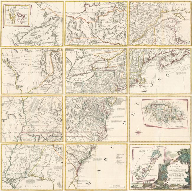
Auction 184, Lot 141
Subject: Colonial Eastern United States & Canada
Zatta, Antonio
[On 12 Sheets] Le Colonie Unite dell' America Settentrle. di Nuova Projezione... , 1778
Size: 16.7 x 12.5 inches (42.4 x 31.8 cm)
Estimate: $4,750 - $6,000
Impressive 12-Sheet Map of the New "United Colonies"
Sold for: $4,500
Closed on 9/15/2021
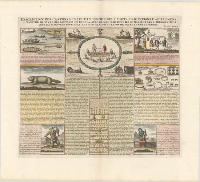
Auction 183, Lot 77
Subject: Canada
Chatelain, Henry Abraham
Description des Castors & de Leur Industrie, des Canots, Habitations, Habillemens Maniere de Vivre des Sauvages du Canada avec la Maniere dont ils se Marient les Hieroglyphes..., 1708
Size: 16.8 x 14.4 inches (42.7 x 36.6 cm)
Estimate: $240 - $300
Sold for: $190
Closed on 6/9/2021
Auction 181, Lot 95
Subject: Winnipeg, Canada
Illustrated London News
Winnipeg, the Capital of Manitoba, in the Canadian Dominion, 1881
Size: 12.3 x 8.4 inches (31.2 x 21.3 cm)
Estimate: $160 - $190
Sold for: $120
Closed on 2/10/2021
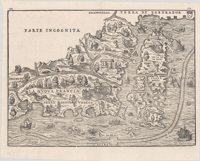
Auction 181, Lot 113
Subject: Colonial Northeastern United States & Canada
Gastaldi/Ramusio
La Nuova Francia, 1606
Size: 14.6 x 10.6 inches (37.1 x 26.9 cm)
Estimate: $3,500 - $4,250
The First Printed Map to Focus on New England and New France
Sold for: $2,750
Closed on 2/10/2021
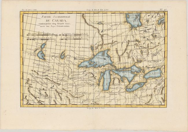
Auction 181, Lot 122
Subject: Colonial Great Lakes
Bonne, Rigobert
Partie Occidentale du Canada, Contenant les Cinq Grands Lac, avec les Pays Circonvoisins, 1790
Size: 12.4 x 8.2 inches (31.5 x 20.8 cm)
Estimate: $220 - $250
Sold for: $150
Closed on 2/10/2021

Auction 179, Lot 122
Subject: Winnipeg, Canada
Illustrated London News
Winnipeg, the Capital of Manitoba, in the Canadian Dominion, 1881
Size: 12.3 x 8.4 inches (31.2 x 21.3 cm)
Estimate: $180 - $210
Unsold
Closed on 9/16/2020
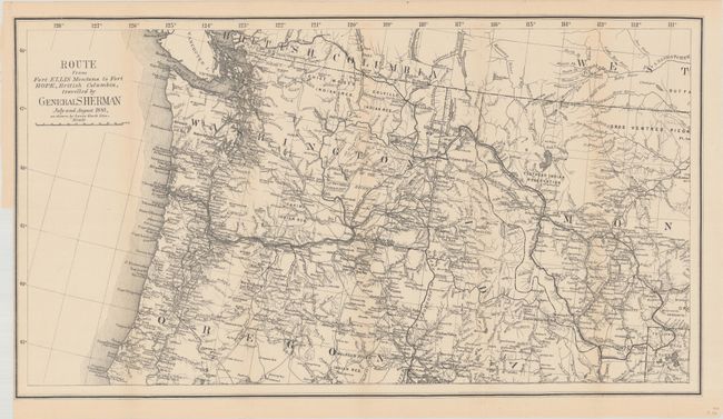
Auction 179, Lot 136
Subject: Northwestern United States & British Columbia
U.S. Government
Route from Fort Ellis Montana to Fort Hope, British Columbia, Travelled by General Sherman July and August 1883, as Shown by Heavy Black Line, 1883
Size: 27.4 x 15.2 inches (69.6 x 38.6 cm)
Estimate: $275 - $350
Sold for: $425
Closed on 9/16/2020
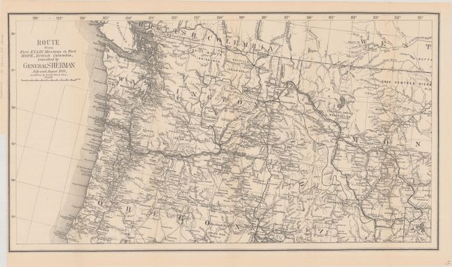
Auction 178, Lot 95
Subject: Northwestern United States & British Columbia
U.S. Government
Route from Fort Ellis Montana to Fort Hope, British Columbia, Travelled by General Sherman July and August 1883, as Shown by Heavy Black Line, 1883
Size: 27.4 x 15.2 inches (69.6 x 38.6 cm)
Estimate: $275 - $350
Sold for: $200
Closed on 6/10/2020
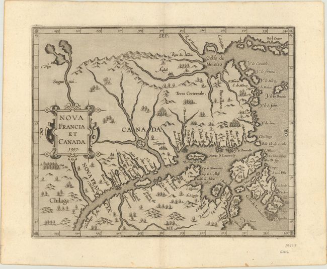
Auction 177, Lot 76
Subject: Eastern Canada
Wytfliet, Cornelis
Nova Francia et Canada, 1597
Size: 11.3 x 9.1 inches (28.7 x 23.1 cm)
Estimate: $1,200 - $1,500
First State of Wytfliet's Landmark Map of Eastern Canada
Sold for: $2,300
Closed on 4/29/2020
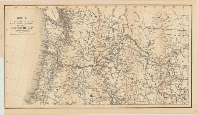
Auction 177, Lot 102
Subject: Northwestern United States, British Columbia
U.S. Government
Route from Fort Ellis Montana to Fort Hope, British Columbia, Travelled by General Sherman July and August 1883, as Shown by Heavy Black Line, 1883
Size: 27.4 x 15.2 inches (69.6 x 38.6 cm)
Estimate: $275 - $350
Sold for: $200
Closed on 4/29/2020
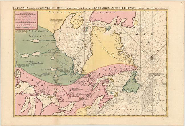
Auction 176, Lot 80
Subject: Eastern Canada, Great Lakes
Mortier, Pierre
Le Canada ou Partie de la Nouvelle France, Contenant la Terre de Labrador la Nouvelle France, les Isles de Terre Neuve. De Nostre Dame &c:, 1693
Size: 30.8 x 21.5 inches (78.2 x 54.6 cm)
Estimate: $1,600 - $1,900
Sold for: $1,300
Closed on 2/12/2020
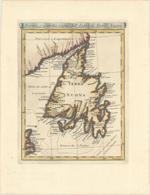
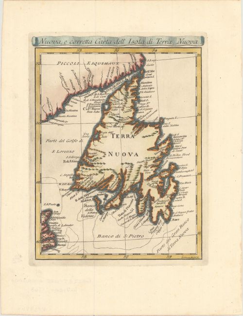
Auction 176, Lot 83
Subject: Newfoundland, Canada
Rossi, Veremondo
Nuova, e Corretta Carta dell' Isola di Terra Nuova, 1763
Size: 6.4 x 8.2 inches (16.3 x 20.8 cm)
Estimate: $160 - $190
Sold for: $120
Closed on 2/12/2020
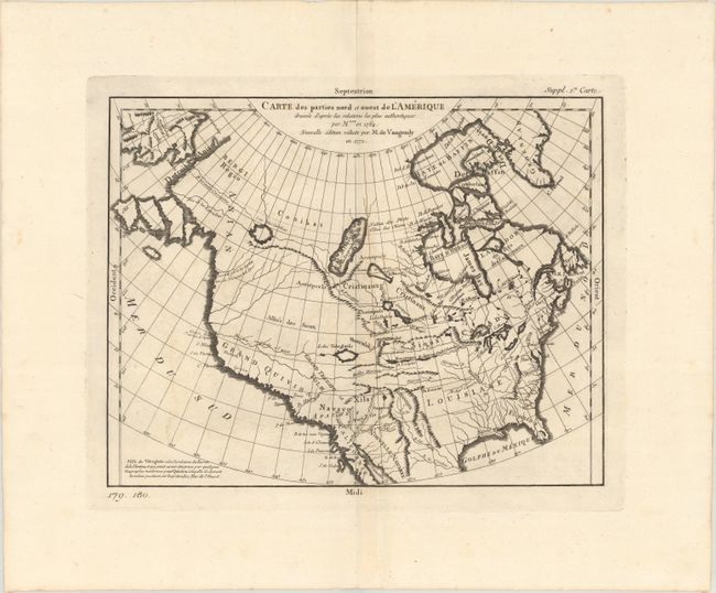
Auction 176, Lot 87
Subject: Colonial United States & Canada
Robert de Vaugondy, Didier
Carte des Parties Nord et Ouest de l'Amerique Dressee d'Apres les Relations les Plus Authentiques..., 1772
Size: 14.4 x 11.3 inches (36.6 x 28.7 cm)
Estimate: $180 - $220
Sold for: $220
Closed on 2/12/2020
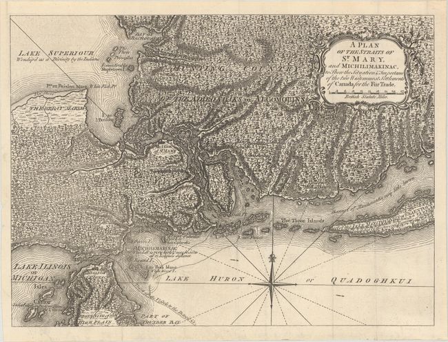
Auction 175, Lot 103
Subject: Colonial Great Lakes
Anon.
A Plan of the Straits of St. Mary, and Michilimakinac, to Shew the Situation & Importance of the Two Westernmost Settlements of Canada for the Fur Trade, 1761
Size: 12.8 x 9.4 inches (32.5 x 23.9 cm)
Estimate: $450 - $550
Sold for: $475
Closed on 11/13/2019
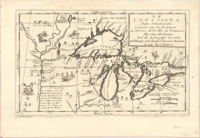
Auction 169, Lot 145
Subject: Colonial Central United States & Canada, Great Lakes
Coronelli, Vincenzo Maria
La Louisiana, Parte Settentrionalle, Scoperta Sotto la Protettione di Luigi XIV, Re di Francia, Etc., 1695
Size: 16.6 x 10.1 inches (42.2 x 25.7 cm)
Estimate: $3,500 - $4,250
Coronelli's Important Map of the Great Lakes & Upper Mississippi River Valley
Sold for: $4,000
Closed on 9/12/2018
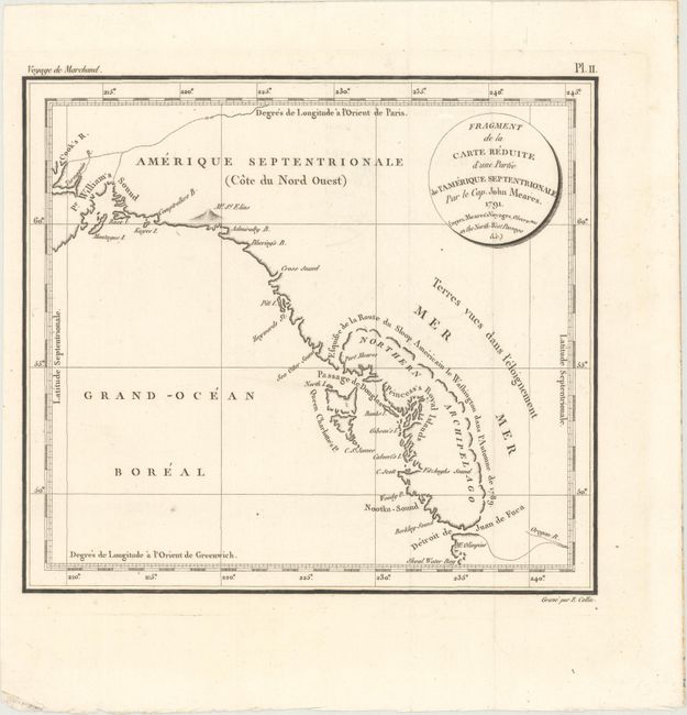
Auction 167, Lot 78
Subject: Pacific Northwest, Southeast Alaska
Meares, John (Capt.)
Fragment de la Carte Reduite d'une Partie de l'Amerique Septentrionale par le Cap. John Meares..., 1798
Size: 9.4 x 8.4 inches (23.9 x 21.3 cm)
Estimate: $400 - $500
Sold for: $300
Closed on 3/28/2018
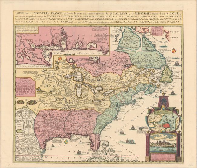
Auction 158, Lot 75
Subject: Colonial Eastern United States & Canada
Fer, Nicolas de
Carte de la Nouvelle France, ou Se Voit le Cours des Grandes Rivieres de S. Laurens & de Mississipi, Aujour d'hui S. Louis…, 1719
Size: 21.7 x 19.6 inches (55.1 x 49.8 cm)
Estimate: $2,750 - $3,500
Striking Map of French Colonial Possessions
Sold for: $2,100
Closed on 6/22/2016
Auction 157, Lot 141
Subject: Colonial Northeastern United States & Canada
D'Anville/Santini
Partie Orientale du Canada, avec la Nouvelle Angleterre, l'Acadie, et la Terre-Neuve..., 1776
Size: 22.8 x 19.2 inches (57.9 x 48.8 cm)
Estimate: $750 - $900
Sold for: $650
Closed on 5/4/2016
Auction 155, Lot 105
Subject: Newfoundland, Canada
Rossi, Veremondo
Nuova, e Corretta Carta dell' Isola di Terra Nuova, 1763
Size: 6.5 x 8.7 inches (16.5 x 22.1 cm)
Estimate: $220 - $250
Unsold
Closed on 11/18/2015
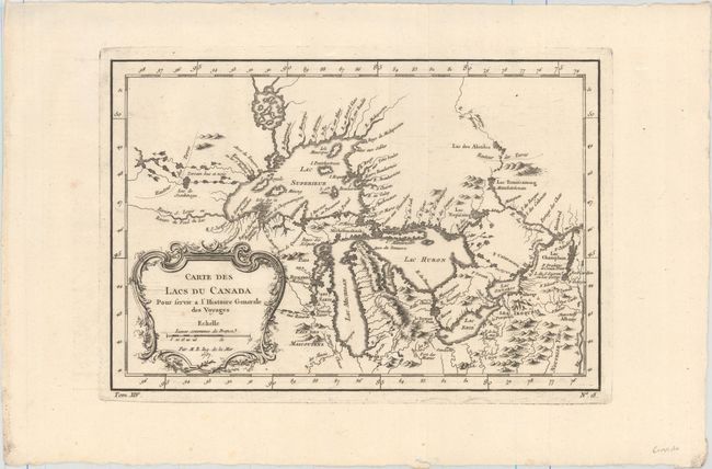
Auction 155, Lot 128
Subject: Colonial Great Lakes
Bellin, Jacques Nicolas
Carte des Lacs du Canada pour Servir a l'Histoire Generale des Voyages, 1757
Size: 11.5 x 7.8 inches (29.2 x 19.8 cm)
Estimate: $400 - $500
Sold for: $350
Closed on 11/18/2015
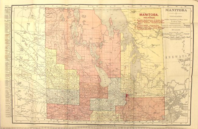
Auction 152, Lot 112
Subject: Manitoba, Canada
Rand McNally & Co.
Manitoba, 1910
Size: 19.1 x 12.7 inches (48.5 x 32.3 cm)
Estimate: $100 - $130
Unsold
Closed on 2/18/2015
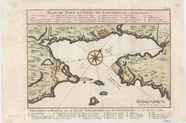
Auction 148, Lot 113
Subject: Cape Breton Island, Canada
Bellin, Jacques Nicolas
Plan du Port et Ville de Louisbourg dans l'Isle Royale, 1756
Size: 11.1 x 7.6 inches (28.2 x 19.3 cm)
Estimate: $160 - $200
Sold for: $110
Closed on 2/19/2014
Auction 146, Lot 121
Subject: Colonial United States & Canada
Delisle/Covens & Mortier
Carte du Canada ou de la Nouvelle France et des Decouvertes quiy ont ete Faites..., 1730
Size: 22.6 x 19.3 inches (57.4 x 49 cm)
Estimate: $1,400 - $1,700
One of the most influential maps of Canada, the Great Lakes and Upper Midwest
Sold for: $1,300
Closed on 9/4/2013
Auction 141, Lot 127
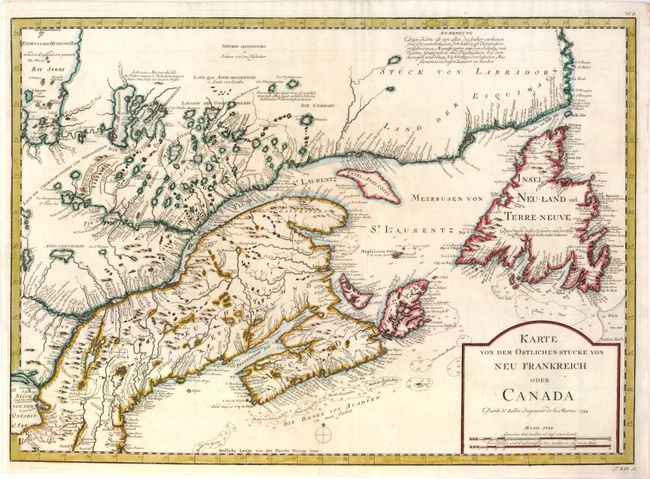
Subject: Colonial United States & Canada
Bellin, Jacques Nicolas
Karte von dem Ostlichen-Stucke von Neu Frankreich oder Canada, 1744
Size: 21.8 x 15.8 inches (55.4 x 40.1 cm)
Estimate: $400 - $500
Sold for: $275
Closed on 9/5/2012

Auction 139, Lot 113
Subject: Canada & Greenland
Zatta, Antonio
La Baja d'Hudson Terra di Labrador e Groenlandia con le Isole Adiacenti di Nuova Projezione, 1778
Size: 16 x 12 inches (40.6 x 30.5 cm)
Estimate: $220 - $275
Sold for: $150
Closed on 2/15/2012

Auction 138, Lot 134
Subject: Colonial United States & Canada
Bellin, Jacques Nicolas
Karte von dem Ostlichen-Stucke von Neu Frankreich oder Canada, 1744
Size: 21.8 x 15.8 inches (55.4 x 40.1 cm)
Estimate: $400 - $500
Unsold
Closed on 12/7/2011
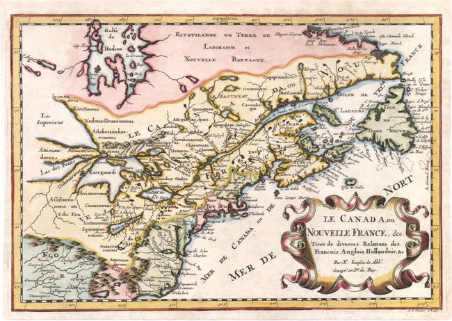
Auction 137, Lot 138
Subject: Colonial United States and Canada - Great Lakes
Sanson, Nicolas
Le Canada, ou Nouvelle France, &c. Tiree de diverses Relations des Francois, Anglois, Hollandois, &c., 1700
Size: 12 x 8.3 inches (30.5 x 21.1 cm)
Estimate: $800 - $950
Small Version of a Keystone Map for Great Lakes Collections
Sold for: $700
Closed on 9/14/2011
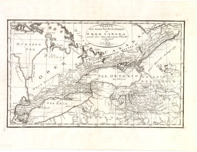
Auction 137, Lot 154
Subject: Canada, United States, & Great Lakes
I.C.M.R.
Charte der Neuen Niederlassungen in Ober Canada nach der Smythschen Charte, 1800
Size: 12.5 x 7.5 inches (31.8 x 19.1 cm)
Estimate: $200 - $250
Sold for: $150
Closed on 9/14/2011
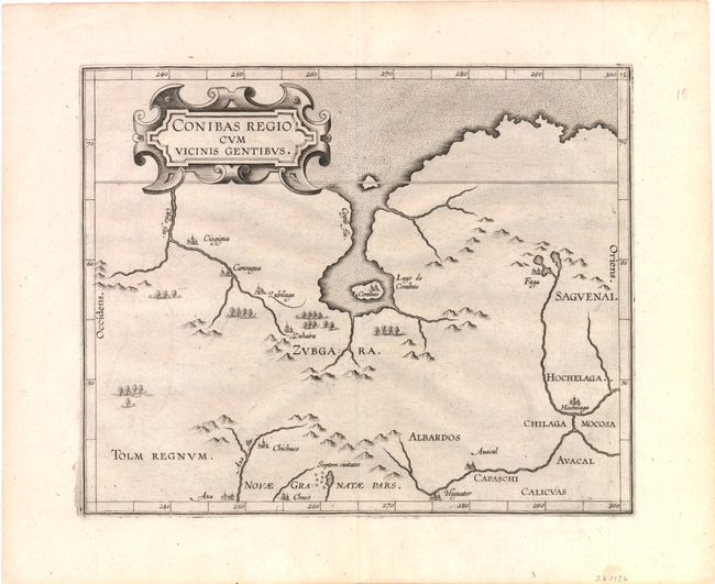
Auction 136, Lot 111
Subject: Canada
Wytfliet, Cornelis
Conibas Regio cum Vicinis Gentibus, 1597
Size: 10.6 x 8.7 inches (26.9 x 22.1 cm)
Estimate: $950 - $1,200
The earliest map of central Canada and Montreal
Sold for: $700
Closed on 6/1/2011
190 lots
Page 1 of 4