Subject: Alaska & British Columbia
Period: 1929 (dated)
Publication:
Color: Printed Color
Size:
29.8 x 16.8 inches
75.7 x 42.7 cm
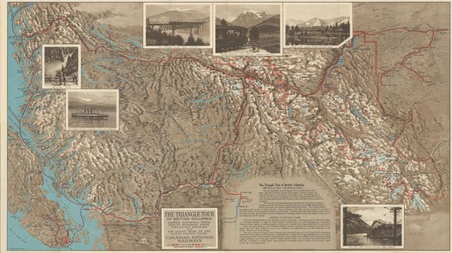
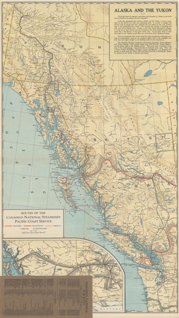
This tourist map details the Canadian National Railway and steamship routes in the Pacific Northwest. It focuses on the southern portion of British Columbia and offers a "triangle tour" between Jasper National Park, Mount Robson Park, and the North Pacific Coast. Mode identifies this as an example of persuasive cartography because the railroad company uses a distorted scale to conveniently eliminate its competitors. The map shows the railroad routes in bold red lines with stops marked by small circles, and the steamship routes along the coastlines are dashed red lines. There are six photographic images showing Bulkley Gate, Vancouver Harbor, the Fraser River, Mount Robson, and scenes from Jasper National Park. On verso is a second map, Alaska and the Yukon (16.8 x 29.8") with an inset showing the routes of the Canadian National Steamships Pacific Coast Service. Folds into brown paper wrappers with the title Map of Canadian Rockies and the Triangle Tour of British Columbia - Alaska and the Yukon. Another small map on the inside cover shows the railway routes spanning Canada from Halifax to Vancouver. Published by Canadian National Railway Company.
References: cf. PJ Mode Collection #1219.
Condition: A+
The map is fine, issued folding. Paper wrappers have minor wear.