Subject: Colonial Eastern United States & Canada, Great Lakes
Period: 1700 (circa)
Publication: Description de Tout l'Univers
Color: Black & White
Size:
11.9 x 8.1 inches
30.2 x 20.6 cm
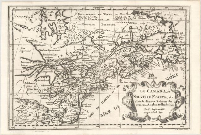
This is a reduced version of one of the most influential seventeenth century maps of the French and English colonies in North America. It concentrates on the region of greatest French interest. The entire Great Lakes basin and the St. Lawrence River are shown in great detail. The most important aspect of the map is the first appearance of L. Erie, ou du Chat as a recognizable lake on an atlas map. This delineation influenced the cartography of the region for more than 100 years and was not superceded until Delisle's Carte du Canada in 1703. The map is also an outstanding source for Indian tribal names and locations. Two names, Aouentsiouaeron and Attiouandarons, appear here for the first time. Lake Superior and Michigan (Lac du Puans) are left open-end to the west. Embellished with a nice title cartouche. Engraved by Anthony d'Winter. This is the second state, with the additions of a latitude and longitude grid and mountains and trees in previously unengraved areas.
Sanson's small maps from his L'Amerique en Plusieurs Cartes..., first published in 1656 and engraved by A. Peyrounin, were copied several times by various map publishers. Johann David Zunners made copies of Sanson's maps for his German translation of Die Gantze Erd-Kugel in 1679. Johannes Ribbius and Simon de Vries published copies in 1682 and 1683, with new maps engraved by Antoine d'Winter. The plates were later sold to Francois Halma, who used them in 1699 and then again in 1705 with the titles re-engraved in Dutch. The titles on the d'Winter plates were re-engraved back into French, and then used by Nicholas Chemereau in 1715 and by Henri du Sauzet in 1738.
References: Burden #575; Kershaw #137; McCorkle #683.6; Pastoureau, SANSON II G.
Condition: A+
A dark impression issued folding on a bright sheet with the watermark of papermakers Jacob & Adriaen Cornelisz. Honigh.