Subject: Colonial Central United States & Canada, Great Lakes
Period: 1695 (circa)
Publication: Atlante Veneto
Color: Black & White
Size:
16.6 x 10.1 inches
42.2 x 25.7 cm
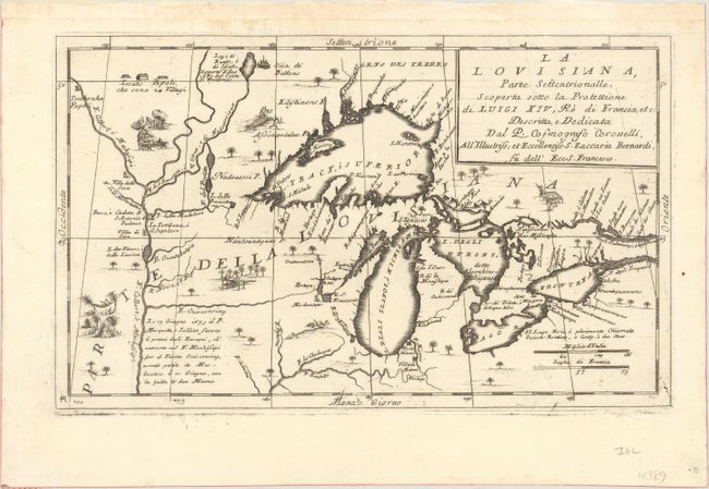
Beautiful and important map of the Great Lakes region from the reports of Jesuit missionaries such as La Salle, Joliet, Hennepin and others who traveled along the Mississipi and Great Lakes. R. de Chekagou is shown at the location of present-day Chicago. Lake Superior is shown very accurately, naming the Keweenaw Peninsula (P. Kioanan) and locating Isle Royale (I. Miniong). It does not show the fictitious islands that begin with Bellin later in the 18th century. The map is filled with scenes of natives drying fish, hanging around in hammocks, and an incongruent scene of an alligator swallowing a native. This map is based on a portion of the Nolin/Coronelli map, "Partie Occidentale du Canada ou de la Nouvelle France…," and was introduced in the second edition of Coronelli's important Atlante Veneto (1695-97).
References: Burden #701; Kershaw #163; Karpinski (MI) p. 117.
Condition: A+
Fine. A dark impression on a very clean sheet. There is a bit of hinge tape in the top blank margin from a previous framing.