Subject: Canada
Period: 1597 (circa)
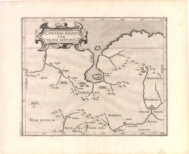
Publication: Descriptionis Ptolemaicae Augmentum
Color: Black & White
Size:
10.6 x 8.7 inches
26.9 x 22.1 cm
Published in Wytfliet's important first atlas devoted to the New World, this fascinating map is cartographically important for a number of reasons. Despite the fact that it covers an area virtually unknown to Europeans, it is the earliest map to focus on the central region of Canada and it is the earliest description of the Native American settlement of Hochelaga, which would become Montreal. A large inland sea, Lago de Conibas, is variously considered to be the first description of Hudson Bay, the remnants of the Verrazzano sea theory, a misplaced representation of the Great Lakes from indigenous sources, or is just entirely imaginary as are most of the rivers and place names on the map. A cluster of cities labeled Septem Civitates is located in the lower portion of the map, a reference to the fabled Seven Cities of Cibola. This legend is among the myths that lured Spaniards into the far reaches of northern New Spain in the 1500s. This is the third variant with an unnamed island at the entrance to the inland sea and the city name, Higuater, above the 275° meridian at bottom. It was published in the third printing of 1597 and all subsequent editions through 1615.
References: Burden #100; Kershaw #39; Verner & Stubbs #18.
Condition: A+
A fine example with a sharp impression and wide original margins.