Filtered by Category:Canada(Show All Categories)
Showing results for:Auction 171
Catalog Archive
26 lots
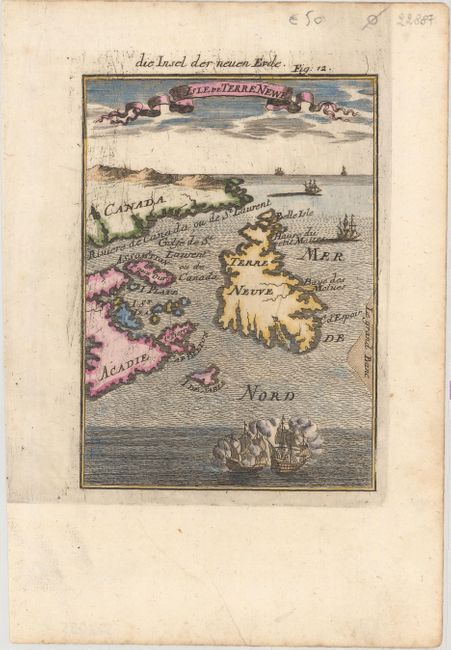
Auction 171, Lot 112
Subject: Eastern Canada
Mallet, Alain Manesson
Isle de Terre Newe, 1684
Size: 4.1 x 5.8 inches (10.4 x 14.7 cm)
Estimate: $180 - $210
Sold for: $90
Closed on 2/6/2019
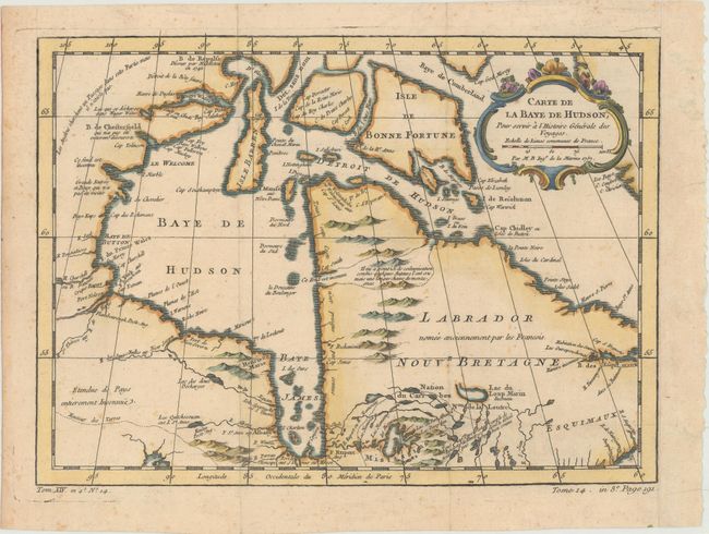
Auction 171, Lot 113
Subject: Eastern Canada, Hudson Bay
Bellin, Jacques Nicolas
Carte de la Baye de Hudson, pour Servir a l'Histoire Generale des Voyages, 1757
Size: 11.9 x 8.6 inches (30.2 x 21.8 cm)
Estimate: $100 - $130
Sold for: $75
Closed on 2/6/2019
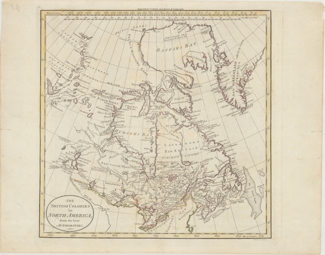
Auction 171, Lot 114
Subject: Eastern Canada
Guthrie, William
The British Colonies in North America, from the Best Authorities, 1780
Size: 13.4 x 13.2 inches (34 x 33.5 cm)
Estimate: $140 - $170
Sold for: $110
Closed on 2/6/2019
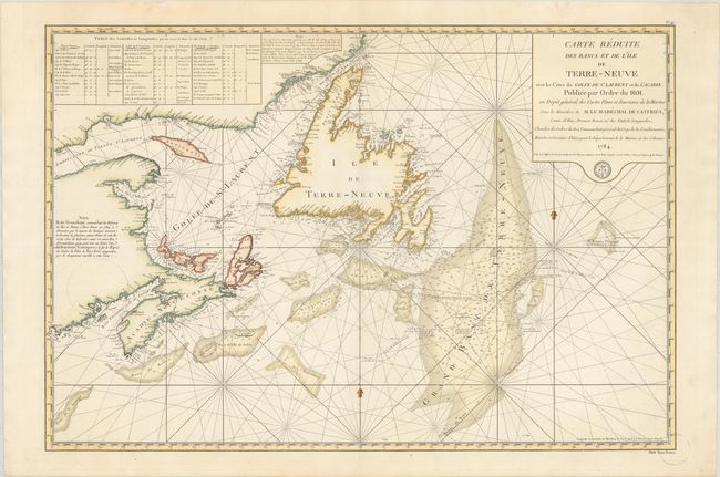
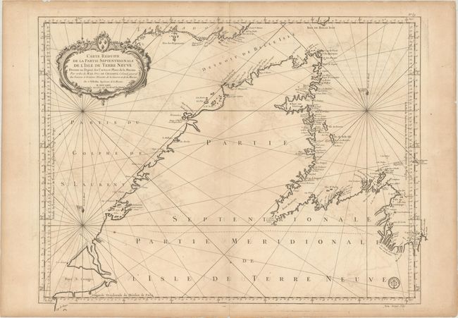
Auction 171, Lot 115
Subject: Eastern Canada
Depot de la Marine
Carte Reduite des Bancs et de l'Ile de Terre-Neuve avec les Cotes du Golfe de St. Laurent et de l'Acadie..., 1784
Size: 33.9 x 22.9 inches (86.1 x 58.2 cm)
Estimate: $450 - $550
Sold for: $350
Closed on 2/6/2019
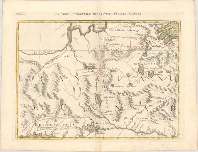
Auction 171, Lot 116
Subject: Eastern Canada
Zatta, Antonio
La Parte Occidentale della Nuova Francia o Canada, 1785
Size: 16.6 x 12 inches (42.2 x 30.5 cm)
Estimate: $150 - $180
Unsold
Closed on 2/6/2019
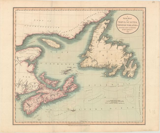
Auction 171, Lot 117
Subject: Eastern Canada
Cary, John
A New Map of Nova Scotia, Newfoundland &c. from the Latest Authorities, 1807
Size: 20.3 x 17.9 inches (51.6 x 45.5 cm)
Estimate: $140 - $170
Sold for: $85
Closed on 2/6/2019
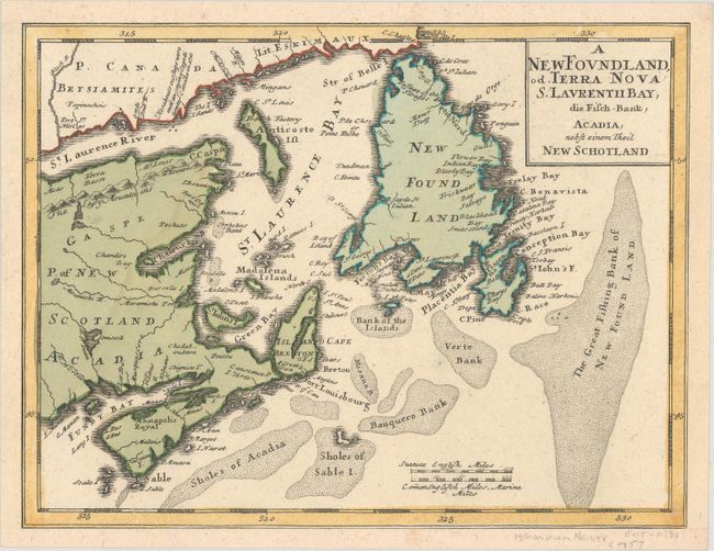
Auction 171, Lot 118
Subject: Canadian Maritimes & Newfoundland
Homann Heirs
A Newfoundland, od. Terra Nova S. Laurentii Bay, die Fisch-Bank, Acadia, nebst Einem Theil New Schotland, 1757
Size: 10.5 x 8 inches (26.7 x 20.3 cm)
Estimate: $220 - $250
Sold for: $170
Closed on 2/6/2019
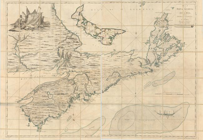
Auction 171, Lot 119
Subject: Canadian Maritimes
Montresor, John
[On 4 Joined Sheets] Map of Nova Scotia, or Acadia; with the Islands of Cape Breton and St. John's, from Actual Surveys... , 1768
Size: 56.4 x 40.6 inches (143.3 x 103.1 cm)
Estimate: $6,000 - $7,500
Montresor's Colossal Map of the Maritimes
Sold for: $6,000
Closed on 2/6/2019
Auction 171, Lot 120
Subject: Newfoundland, Canada
Bellin, Jacques Nicolas
Carte Reduite de la Partie Septentrionale de l'Isle de Terre Neuve Dressee au Depost des Cartes et Plans de la Marine..., 1767
Size: 31.3 x 23.7 inches (79.5 x 60.2 cm)
Estimate: $275 - $350
Sold for: $200
Closed on 2/6/2019
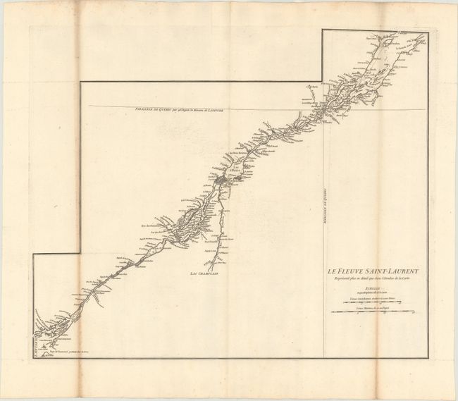
Auction 171, Lot 121
Subject: St. Lawrence River, Canada
[Lot of 2] Le Fleuve Saint-Laurent Represente Plus en Detail que dans l'Etendue de la Carte [and] The River St. Lawrence, Accurately Drawn from D'Anville's Map Publish'd Under the Patronage of the Duke of Orleans, 1755-84
Size: See Description
Estimate: $275 - $350
Unsold
Closed on 2/6/2019
Auction 171, Lot 122
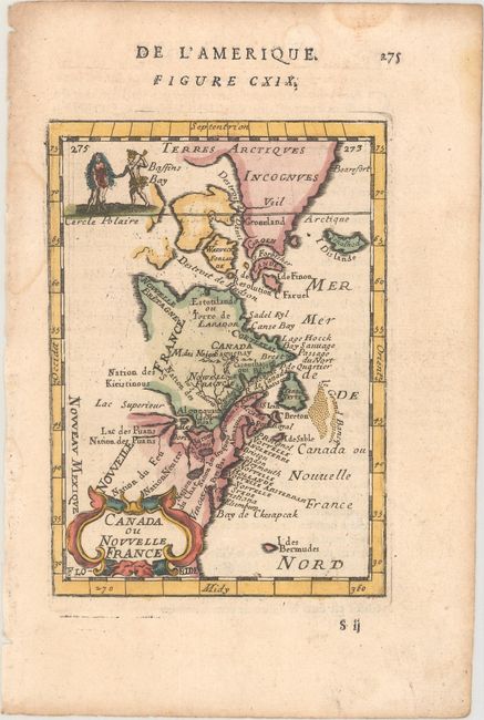
Subject: Colonial Eastern United States & Canada
Mallet, Alain Manesson
Canada ou Nouvelle France, 1683
Size: 4 x 5.6 inches (10.2 x 14.2 cm)
Estimate: $200 - $230
Sold for: $150
Closed on 2/6/2019
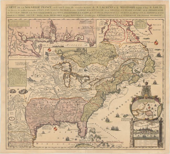
Auction 171, Lot 123
Subject: Colonial Eastern United States & Canada
Fer, Nicolas de
Carte de la Nouvelle France, ou se voit le Cours des Grandes Rivieres de S. Laurens & de Mississipi Aujour d'hui S. Louis, aux Environs des-quelles se Trouvent les Etats, Pais, Nations, Peuples &c..., 1719
Size: 21.4 x 19.5 inches (54.4 x 49.5 cm)
Estimate: $2,300 - $2,750
Striking Map of French Colonial Possessions
Sold for: $1,700
Closed on 2/6/2019
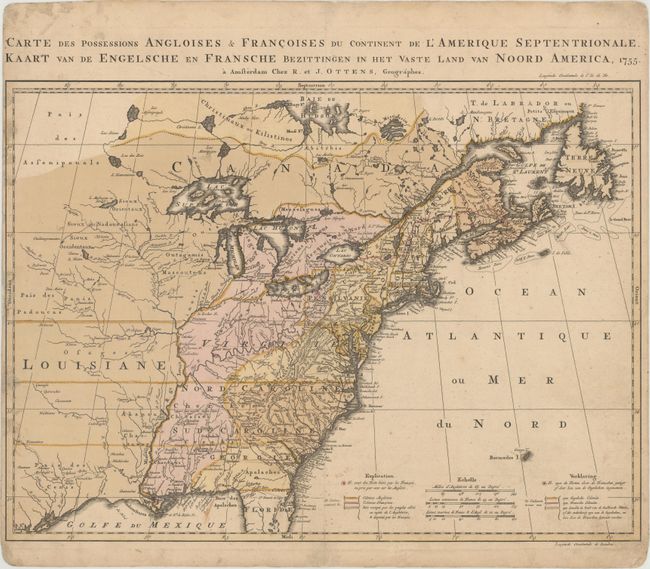
Auction 171, Lot 124
Subject: Colonial Eastern United States & Canada
Ottens, Reiner and Joshua
Carte des Possessions Angloises & Francoises du Continent de l'Amerique Septentrionale / Kaart van de Engelsche en Fransche Bezittingen in het Vaste Land van Noord America, 1755
Size: 22.4 x 16.3 inches (56.9 x 41.4 cm)
Estimate: $2,000 - $2,300
Dutch Version of an Important Map Showing Territorial Claims at the Outset of the French and Indian War
Unsold
Closed on 2/6/2019
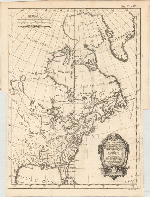
Auction 171, Lot 125
Subject: Colonial Eastern United States & Canada
Bonne, Rigobert
Partie du Nord de l'Amerique Septentrionale. Pour Servir a l'Histoire Philosophique et Politique…, 1774
Size: 9.3 x 12.6 inches (23.6 x 32 cm)
Estimate: $180 - $220
Sold for: $100
Closed on 2/6/2019
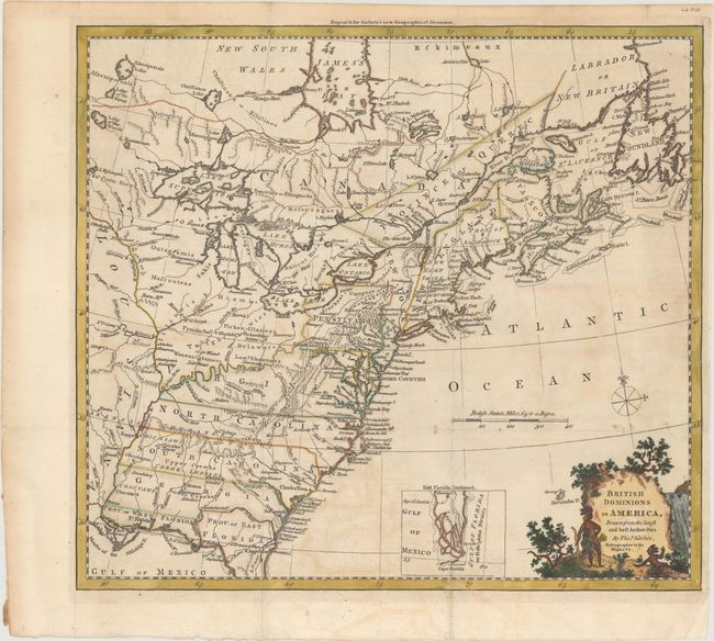
Auction 171, Lot 126
Subject: Colonial Eastern United States & Canada
Kitchin, Thomas
British Dominions in America, Drawn from the Latest and Best Authorities, 1780
Size: 14.8 x 13.4 inches (37.6 x 34 cm)
Estimate: $550 - $700
Sold for: $400
Closed on 2/6/2019
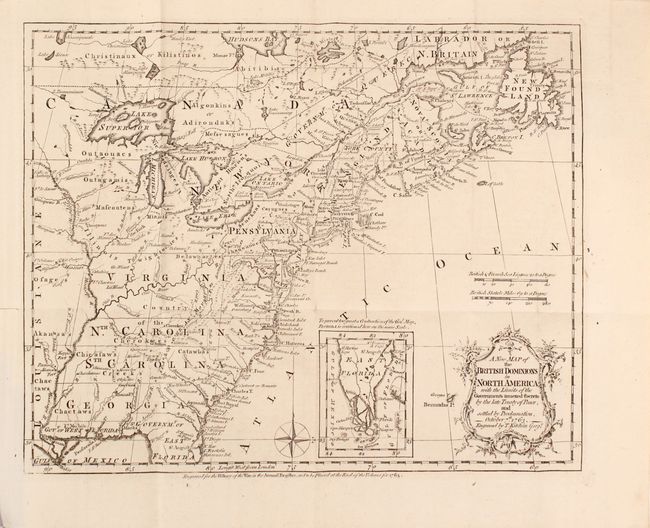
Auction 171, Lot 127
Subject: Colonial Eastern United States & Canada, History Book
Kitchin, Thomas
[Maps in Book] A New Map of the British Dominions in North America; with the Limits of the Governments Annexed Thereto by the Late Treaty of Peace... [bound in] The Annual Register, or a View of the History, Politics, and Literature…, 1782
Size: 11.8 x 9.5 inches (30 x 24.1 cm)
Estimate: $700 - $850
Sold for: $500
Closed on 2/6/2019
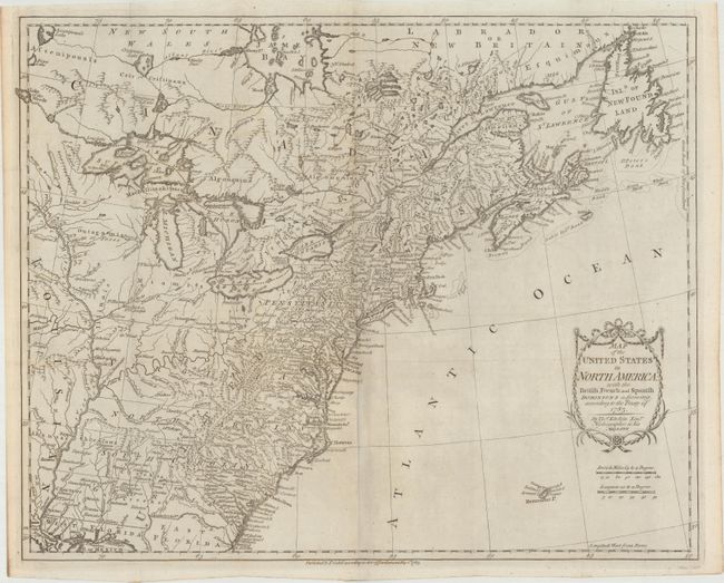
Auction 171, Lot 128
Subject: Eastern United States & Canada
Kitchin, Thomas
Map of the United States in North America: with the British, French and Spanish Dominions Adjoining, According to the Treaty of 1783, 1783
Size: 20.2 x 16.1 inches (51.3 x 40.9 cm)
Estimate: $1,200 - $1,500
Sold for: $850
Closed on 2/6/2019
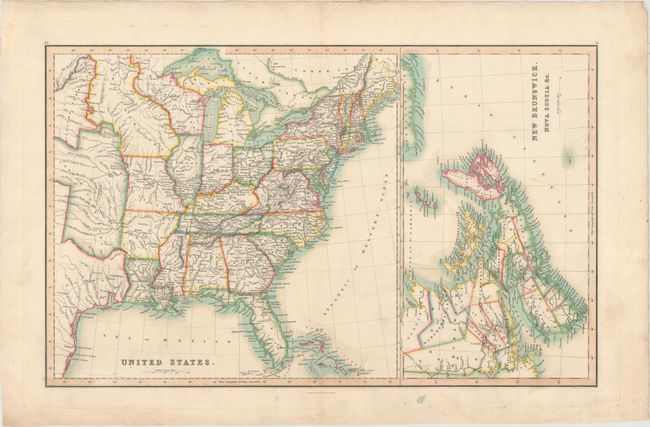
Auction 171, Lot 129
Subject: Eastern United States & Canada
Smith & Son
United States [on sheet with] New Brunswick, Nova Scotia &c., 1846
Size: 22.7 x 14.1 inches (57.7 x 35.8 cm)
Estimate: $160 - $190
Sold for: $95
Closed on 2/6/2019
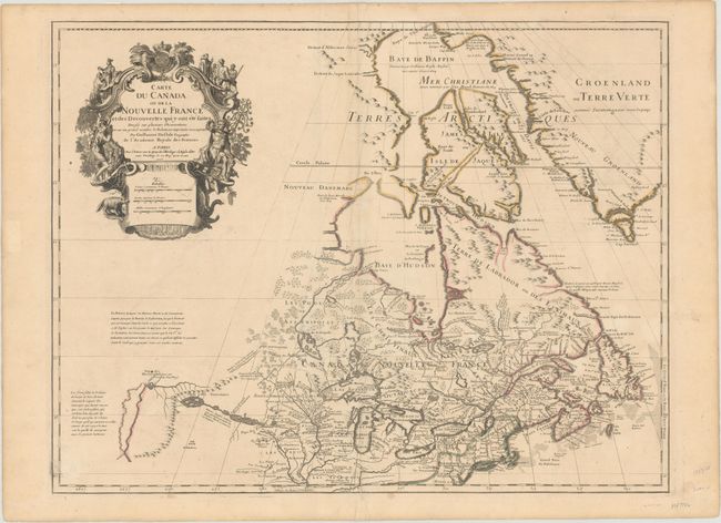
Auction 171, Lot 130
Subject: Colonial Northeastern United States & Canada, Great Lakes
Delisle, Guillaume
Carte du Canada ou de la Nouvelle France et des Decouvertes qui y ont ete Faites Dressee sur Plusieurs Observations..., 1703
Size: 25.6 x 19.6 inches (65 x 49.8 cm)
Estimate: $2,200 - $2,500
Delisle's Seminal Map of Canada and the Great Lakes
Sold for: $1,200
Closed on 2/6/2019
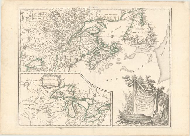
Auction 171, Lot 131
Subject: Colonial Northeastern United States & Canada, Great Lakes
Robert de Vaugondy, Didier
Partie de l'Amerique Septent? qui Comprend la Nouvelle France ou le Canada, 1784
Size: 23.8 x 18.8 inches (60.5 x 47.8 cm)
Estimate: $550 - $700
Sold for: $400
Closed on 2/6/2019
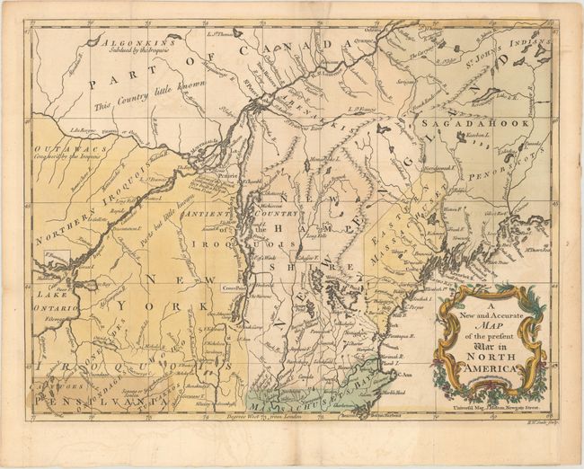
Auction 171, Lot 132
Subject: Colonial Northeastern United States & Canada
Hinton, John
A New and Accurate Map of the Present War in North America, 1757
Size: 14.4 x 10.8 inches (36.6 x 27.4 cm)
Estimate: $475 - $600
Sold for: $450
Closed on 2/6/2019
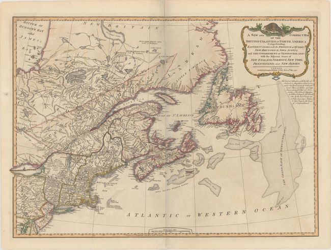
Auction 171, Lot 133
Subject: Northeastern United States & Canada
Laurie & Whittle
A New and Correct Map of the British Colonies in North America Comprehending Eastern Canada with the Province of Quebec, New Brunswick, Nova Scotia, and the Government of Newfoundland: with the Adjacent States of New England..., 1794
Size: 26.3 x 18.9 inches (66.8 x 48 cm)
Estimate: $550 - $650
Sold for: $425
Closed on 2/6/2019
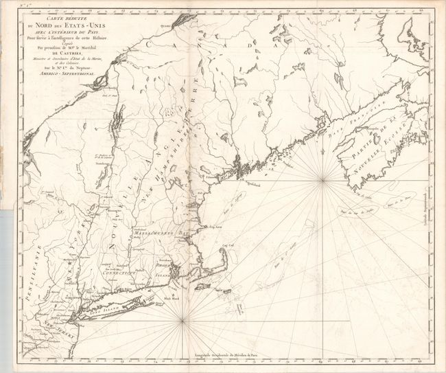
Auction 171, Lot 134
Subject: Northeastern United States & Canada
Carte Reduite du Nord des Etats-Unis avec l'Interieur du Pays. Pour Servir a Intelligence de Cette Histoire..., 1830
Size: 22.9 x 19.6 inches (58.2 x 49.8 cm)
Estimate: $375 - $450
Unsold
Closed on 2/6/2019
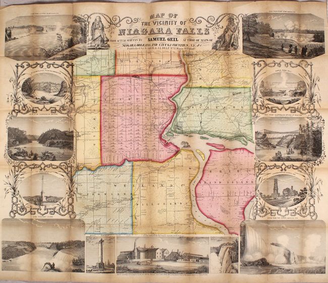
Auction 171, Lot 135
Subject: Niagara Falls, New York, Canada
Geil, Samuel
Map of the Vicinity of Niagara Falls from Actual Surveys..., 1853
Size: 28.3 x 22.7 inches (71.9 x 57.7 cm)
Estimate: $350 - $425
Sold for: $1,400
Closed on 2/6/2019
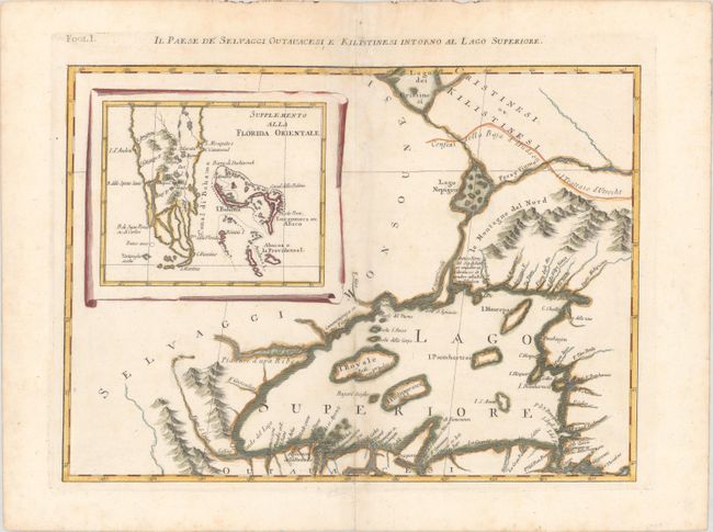
Auction 171, Lot 136
Subject: Great Lakes, Florida
Zatta, Antonio
Il Paese de Selvaggi Outauacesi, e Kilistinesi Intorno al Lago Superiore, 1785
Size: 16.6 x 12.1 inches (42.2 x 30.7 cm)
Estimate: $250 - $325
Sold for: $110
Closed on 2/6/2019
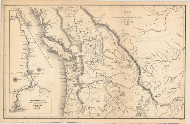
Auction 171, Lot 137
Subject: Northwestern United States & Canada
Wilkes, Charles
Map of the Oregon Territory by the U.S. Ex. Ex., 1841
Size: 13.1 x 8.2 inches (33.3 x 20.8 cm)
Estimate: $200 - $230
Sold for: $150
Closed on 2/6/2019
26 lots