Filtered by Category:Pacific Ocean, New Zealand, Australia(Show All Categories)
Showing results for:Auction 171
Catalog Archive
15 lots
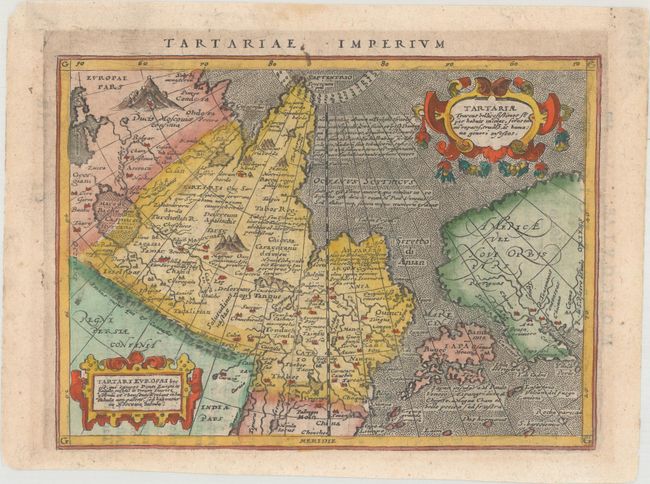
Auction 171, Lot 659
Subject: Northern Asia, North Pacific, & Northwestern North America
Magini, Giovanni Antonio
Tartariae Imperium, 1597
Size: 6.7 x 4.9 inches (17 x 12.4 cm)
Estimate: $200 - $230
Sold for: $150
Closed on 2/6/2019
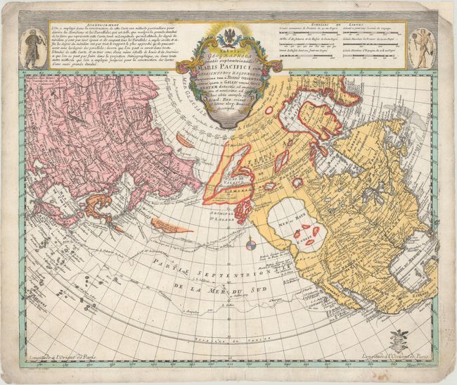
Auction 171, Lot 726
Subject: North Pacific, Northern Asia & North America
Euler, Leonhard
Tabula Geographica Partis Septentrionalis Maris Pacifici cum Adiacentibus Regionibus Nuperrime tam a Russis Orientem..., 1753
Size: 15.1 x 12.8 inches (38.4 x 32.5 cm)
Estimate: $700 - $850
Sold for: $600
Closed on 2/6/2019
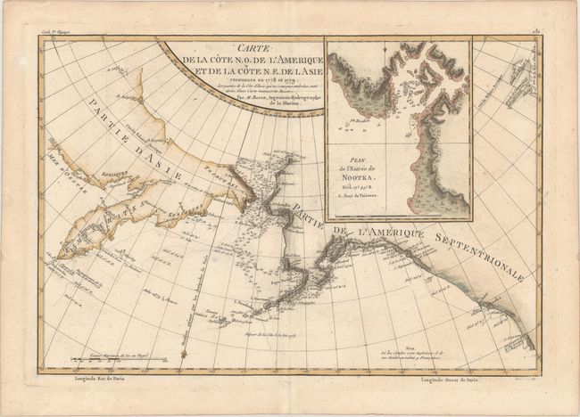
Auction 171, Lot 727
Subject: North Pacific Ocean
Bonne, Rigobert
Carte de la Cote N.O. de l'Amerique et de la Cote N.E. de l Asie Reconnues en 1778 et 1779..., 1787
Size: 13.6 x 9.3 inches (34.5 x 23.6 cm)
Estimate: $100 - $130
Sold for: $80
Closed on 2/6/2019
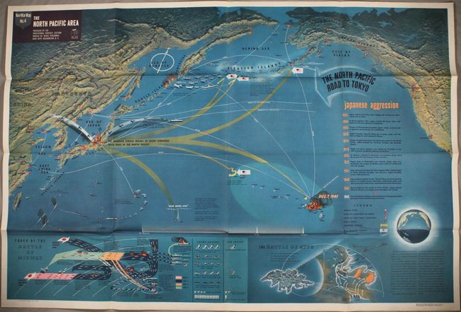
Auction 171, Lot 728
Subject: North Pacific Ocean, World War II
U.S. Navy Dept.
Nav War Map No. 4 - The North Pacific Area, 1944
Size: 57.1 x 38.1 inches (145 x 96.8 cm)
Estimate: $400 - $500
Elaborate, Large-Scale WWII Pictorial Map
Sold for: $475
Closed on 2/6/2019
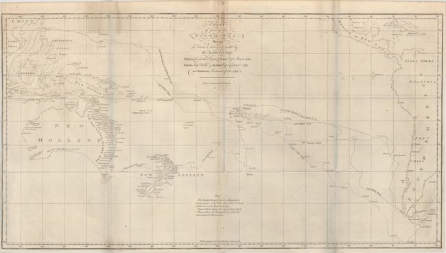
Auction 171, Lot 729
Subject: South Pacific Ocean
Cook, James (Capt.)
Chart of Part of the South Sea, Shewing the Tracts & Discoveries Made by His Majesty's Ships Dolphin, Commodore Byron, & Tamer, Capn Mouat, 1765 ... and Endeavour, Lieutenant Cooke, 1769, 1773
Size: 26.3 x 14 inches (66.8 x 35.6 cm)
Estimate: $1,000 - $1,300
Sold for: $550
Closed on 2/6/2019
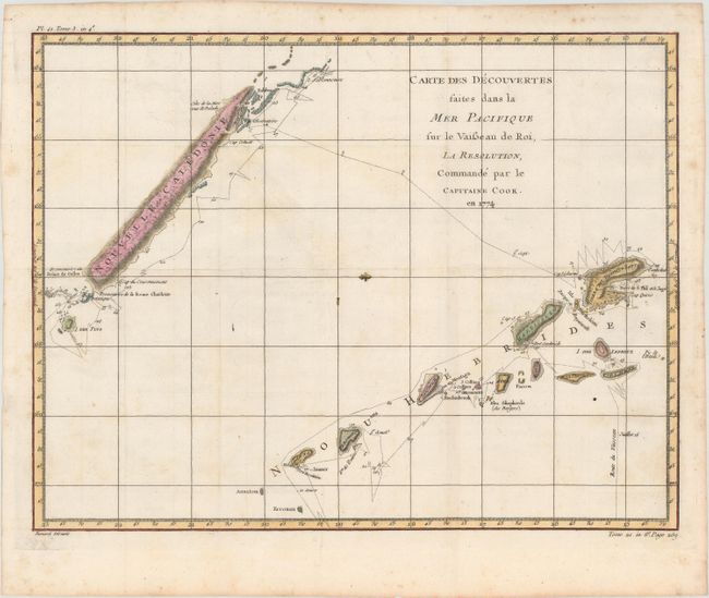
Auction 171, Lot 730
Subject: South Pacific Ocean
Cook/Benard
Carte des Decouvertes Faites dans la Mer Pacifique sur le Vaisseau de Roi, la Resolution, Commande par le Capitaine Cook. En 1774, 1778
Size: 18.2 x 14.1 inches (46.2 x 35.8 cm)
Estimate: $90 - $120
NO RESERVE
Sold for: $230
Closed on 2/6/2019
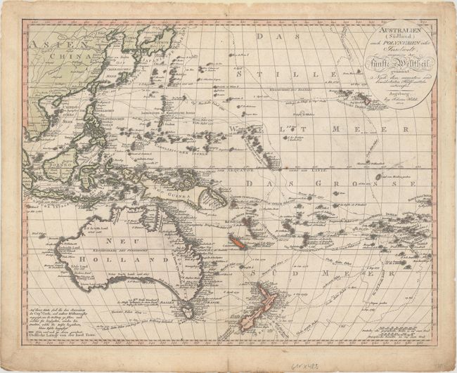
Auction 171, Lot 731
Subject: South Pacific Ocean, Australia
Walch, Johannes
Australien (Sudland) auch Polynesien oder Inselwelt, Insgemein der Funfte Welttheil..., 1802
Size: 23.7 x 18.7 inches (60.2 x 47.5 cm)
Estimate: $700 - $850
Sold for: $475
Closed on 2/6/2019
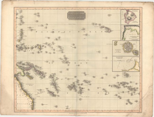
Auction 171, Lot 732
Subject: Pacific Islands
Thomson, John
Map of the Islands in the Pacific Ocean, 1817
Size: 23.5 x 19.4 inches (59.7 x 49.3 cm)
Estimate: $200 - $230
Sold for: $90
Closed on 2/6/2019
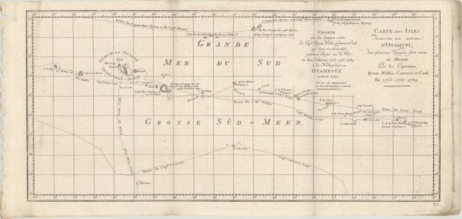
Auction 171, Lot 733
Subject: Pacific Islands, Tahiti
Carte des Isles Decouvertes aux Environs d'Otahiti, dans Plusieurs Voyages Faits Autour du Monde par les Capitaines Byron, Wallis, Carteret et Cook. En 1765. 1767. 1769, 1774
Size: 20.3 x 9.4 inches (51.6 x 23.9 cm)
Estimate: $50 - $70
NO RESERVE
Sold for: $55
Closed on 2/6/2019
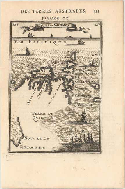
Auction 171, Lot 734
Subject: Salomon Islands
Mallet, Alain Manesson
Isles de Salomon, 1683
Size: 4.1 x 5.9 inches (10.4 x 15 cm)
Estimate: $180 - $220
Sold for: $130
Closed on 2/6/2019
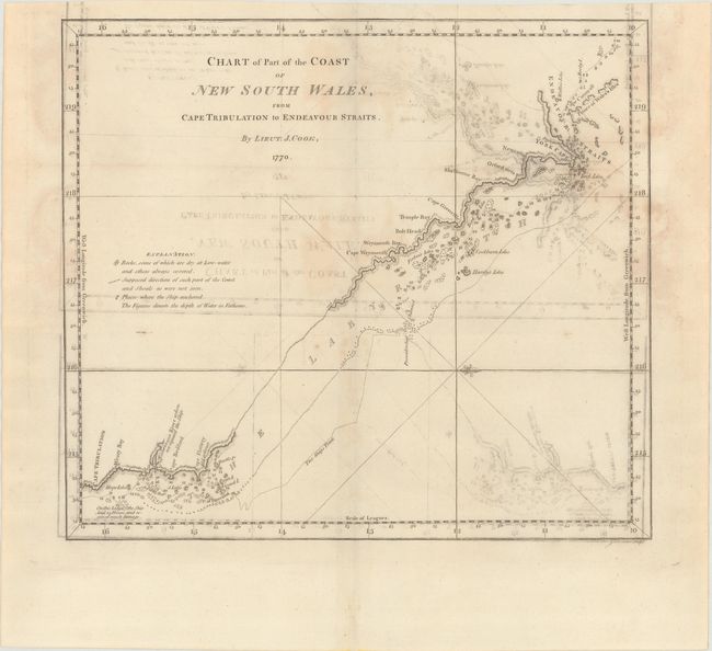
Auction 171, Lot 735
Subject: Northeastern Australia
Cook, James (Capt.)
Chart of Part of the Coast of New South Wales, from Cape Tribulation to Endeavour Straits, 1773
Size: 13.3 x 11.8 inches (33.8 x 30 cm)
Estimate: $300 - $400
NO RESERVE - The Earliest Chart of the Coast of Queensland
Sold for: $85
Closed on 2/6/2019
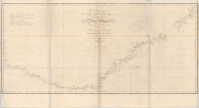
Auction 171, Lot 736
Subject: Eastern Australia
Cook, James (Capt.)
A Chart of New South Wales, or the East Coast of New-Holland. Discover'd and Explored by Lieutenant J. Cook, Commander of His Majesty's Bark Endeavour, in the Year MDCCLXX, 1773
Size: 30.9 x 14.3 inches (78.5 x 36.3 cm)
Estimate: $1,400 - $1,700
First Chart of the East Coast of Australia
Sold for: $800
Closed on 2/6/2019
Auction 171, Lot 737
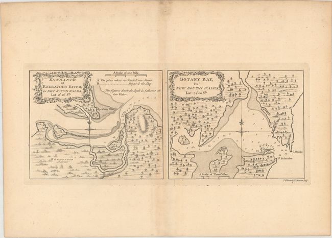
Subject: Sydney & Endeavor River, Australia
Cook, James (Capt.)
Entrance of Endeavour River, in New South Wales... [on sheet with] Botany Bay, in New South Wales..., 1773
Size: 13.2 x 5.3 inches (33.5 x 13.5 cm)
Estimate: $400 - $500
Sold for: $250
Closed on 2/6/2019
Auction 171, Lot 738
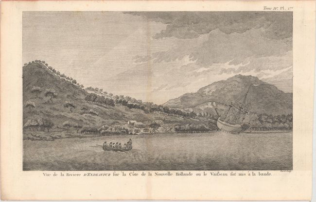
Subject: Endeavour River, Australia
Cook, James (Capt.)
Vue de la Riviere d'Endeavour sur la Cote de la Nouvelle Hollande ou le Vaisseau fut mis a la Bande, 1774
Size: 13.1 x 7.8 inches (33.3 x 19.8 cm)
Estimate: $240 - $300
Sold for: $275
Closed on 2/6/2019
Auction 171, Lot 739
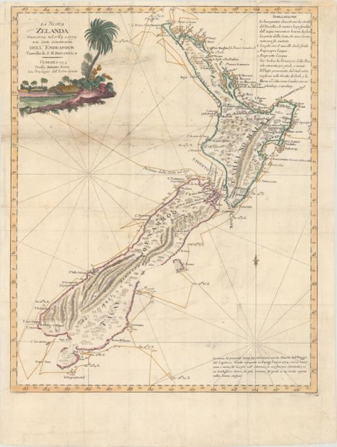
Subject: New Zealand
Zatta, Antonio
La Nuova Zelanda Trascorsa nel 1769 e 1770. dal Cook Comandante dell' Endeavour Vascello di S.M. Britannica, 1794
Size: 14.1 x 17.6 inches (35.8 x 44.7 cm)
Estimate: $1,200 - $1,500
Unsold
Closed on 2/6/2019
15 lots