Filtered by Category:Canada(Show All Categories)
Showing results for:Auction 136
Catalog Archive
39 lots
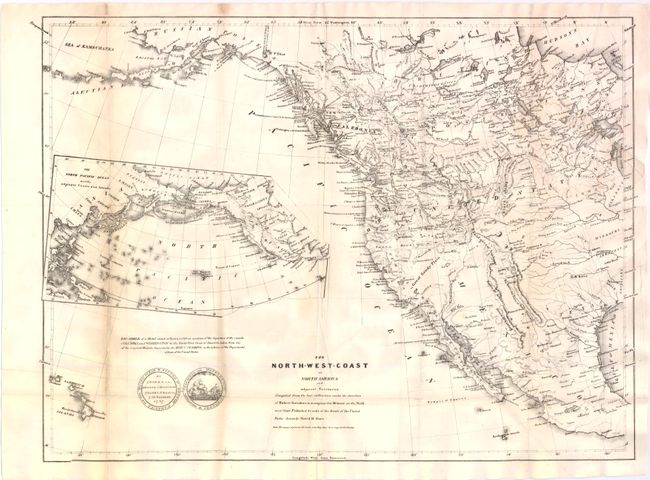
Auction 136, Lot 110
Subject: Western North America
Burr, David H.
The North-West Coast of North America and adjacent Territories…, 1840
Size: 21.38 x 16 inches (54.3 x 40.6 cm)
Estimate: $250 - $325
Sold for: $170
Closed on 6/1/2011
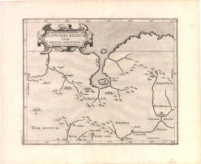
Auction 136, Lot 111
Subject: Canada
Wytfliet, Cornelis
Conibas Regio cum Vicinis Gentibus, 1597
Size: 10.6 x 8.7 inches (26.9 x 22.1 cm)
Estimate: $950 - $1,200
The earliest map of central Canada and Montreal
Sold for: $700
Closed on 6/1/2011
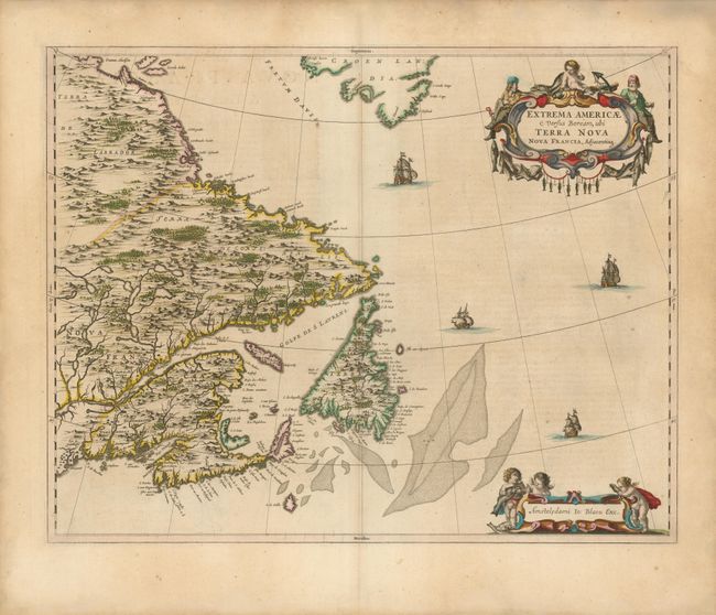
Auction 136, Lot 112
Subject: Canada
Blaeu, Johannes
Extrema Americae Versus Boream, ubi Terra Nova Nova Francia, Adjacentiaq, 1662
Size: 22.3 x 17.5 inches (56.6 x 44.5 cm)
Estimate: $1,900 - $2,300
Sold for: $2,100
Closed on 6/1/2011
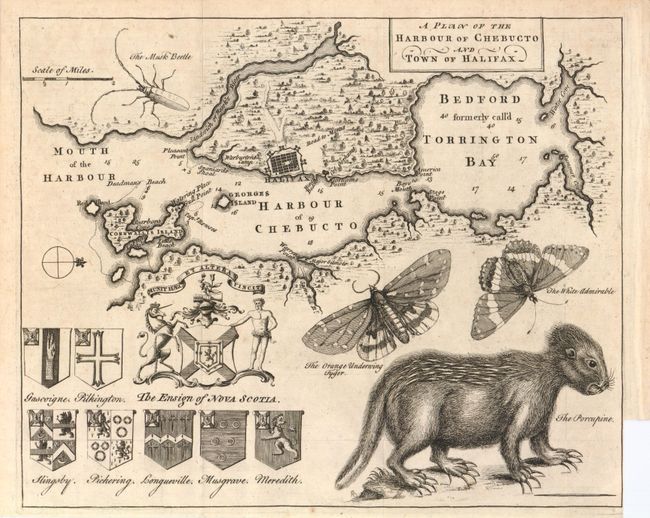
Auction 136, Lot 113
Subject: Halifax, Canada
A Plan of the Harbour of Chebucto and Town of Halifax, 1750
Size: 10.7 x 8.8 inches (27.2 x 22.4 cm)
Estimate: $500 - $700
Sold for: $700
Closed on 6/1/2011
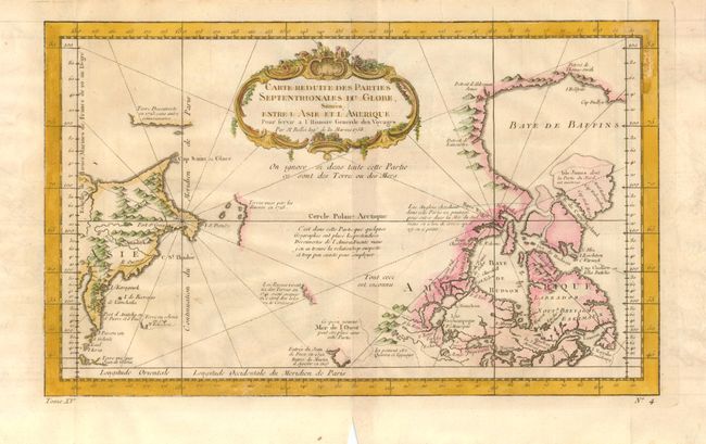
Auction 136, Lot 114
Subject: Canada
Bellin, Jacques Nicolas
[Lot of 4 - Canada], 1750-1760
Size: See Description
Estimate: $400 - $600
Sold for: $325
Closed on 6/1/2011
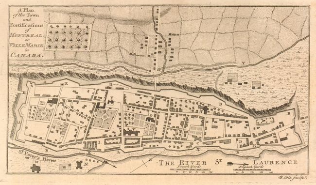
Auction 136, Lot 115
Subject: Montreal, Canada
Anon.
[Lot of 2] A Plan of the Town and Fortifications of Montreal, or Ville Marie in Canada [and] Plan of the town and Fortifications of Montreal or Ville Marie in Canada in 1758, 1758-1839
Size: 7.5 x 4.5 inches (19.1 x 11.4 cm)
Estimate: $200 - $250
Sold for: $275
Closed on 6/1/2011
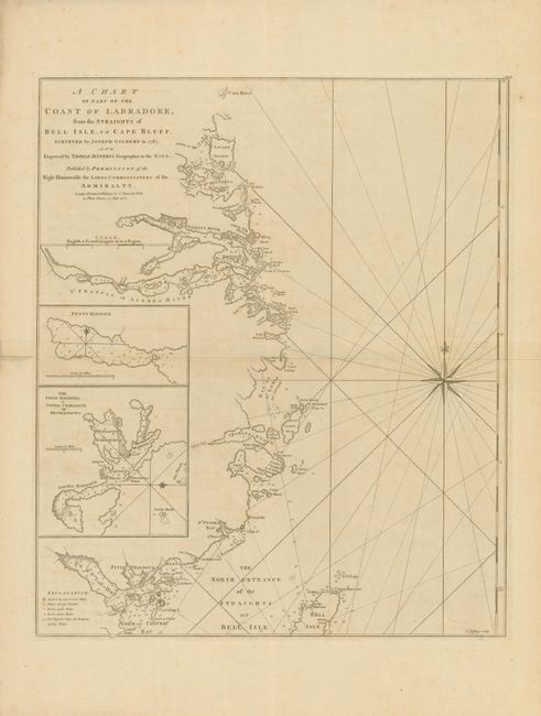
Auction 136, Lot 116
Subject: Eastern Canada
Jefferys, Thomas
A Chart of the Part of the Coast of Labradore, from the Straights of Bell Isle, to Cape Bluff, 1770
Size: 18 x 21.5 inches (45.7 x 54.6 cm)
Estimate: $200 - $250
Sold for: $170
Closed on 6/1/2011
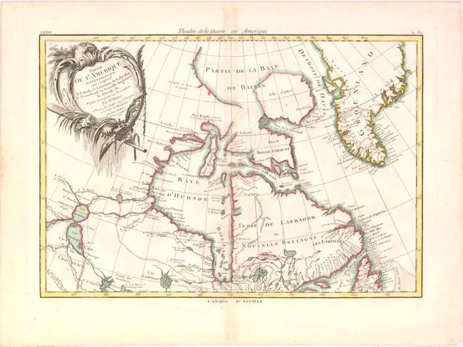
Auction 136, Lot 117
Subject: Canada and Greenland
Bonne/Lattre
Partie de l'Amerique Septentrionale qui comprend le Canada, la Louisiane, le Labrador, le Groenland, la Nouvelle Angleterre, la Floride &c., 1776
Size: 17 x 11.7 inches (43.2 x 29.7 cm)
Estimate: $240 - $325
Unsold
Closed on 6/1/2011
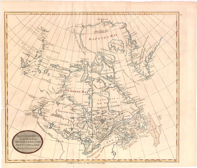
Auction 136, Lot 118
Subject: Canada
Charles, J.
British America, Comprehending Canada, Labrador, New-Foundland, Nova Scotia &c., 1814
Size: 15 x 13 inches (38.1 x 33 cm)
Estimate: $200 - $275
Sold for: $100
Closed on 6/1/2011
Auction 136, Lot 119
Subject: Canada
Lizars, William Home
[Lot of 5 - Maritime Provinces], 1832
Size: See Description
Estimate: $90 - $120
Sold for: $190
Closed on 6/1/2011
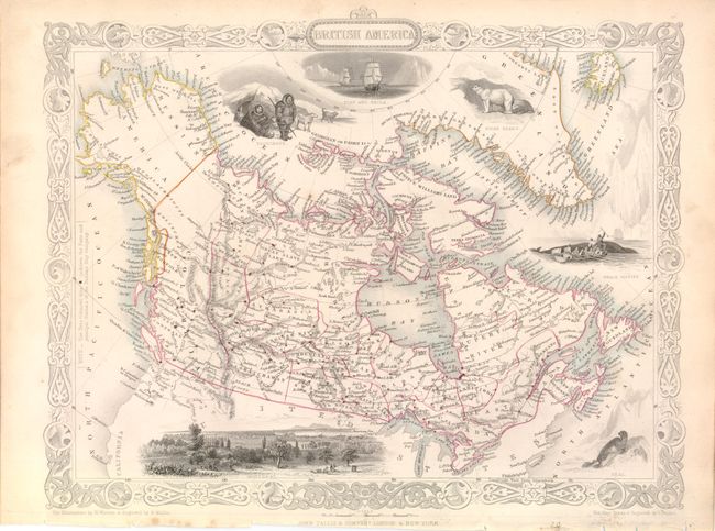
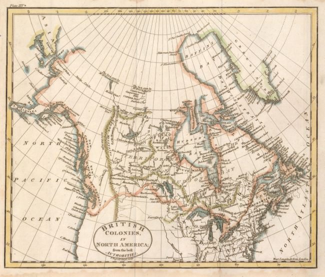
Auction 136, Lot 120
Subject: Canada and Alaska
Tallis, John
British America, 1851
Size: 12.8 x 10.2 inches (32.5 x 25.9 cm)
Estimate: $160 - $200
Sold for: $120
Closed on 6/1/2011
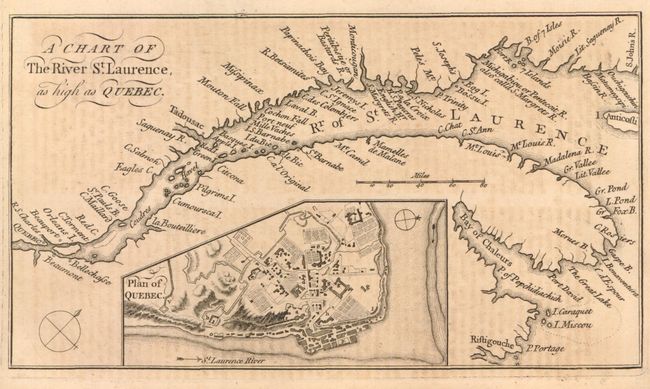
Auction 136, Lot 121
Subject: Canada
Anon.
A Chart of the River St. Laurence, as High as Quebec, 1759
Size: 7.5 x 4.5 inches (19.1 x 11.4 cm)
Estimate: $150 - $200
Unsold
Closed on 6/1/2011
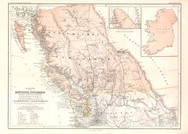
Auction 136, Lot 122
Subject: Canada
Petermann, Augustus Herman
[Lot of 2] Karte von Britisch-Columbia... [and] Die Kuste von Labrador…, 1858-1861
Size: See Description
Estimate: $160 - $190
Sold for: $85
Closed on 6/1/2011
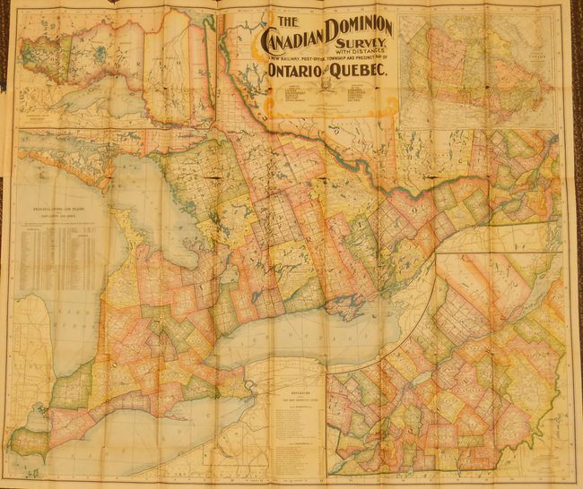
Auction 136, Lot 123
Subject: Canada
The Canadian Dominion Survey, with Distances. A New Railway, Post-Office, Township and Precinct Map of Ontario and Quebec, 1899
Size: 39 x 33.5 inches (99.1 x 85.1 cm)
Estimate: $200 - $400
Sold for: $100
Closed on 6/1/2011
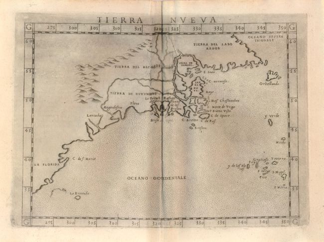
Auction 136, Lot 124
Subject: United States and Canada
Ruscelli, Girolamo
Tierra Nueva, 1574
Size: 9.5 x 7 inches (24.1 x 17.8 cm)
Estimate: $1,000 - $1,300
Unsold
Closed on 6/1/2011
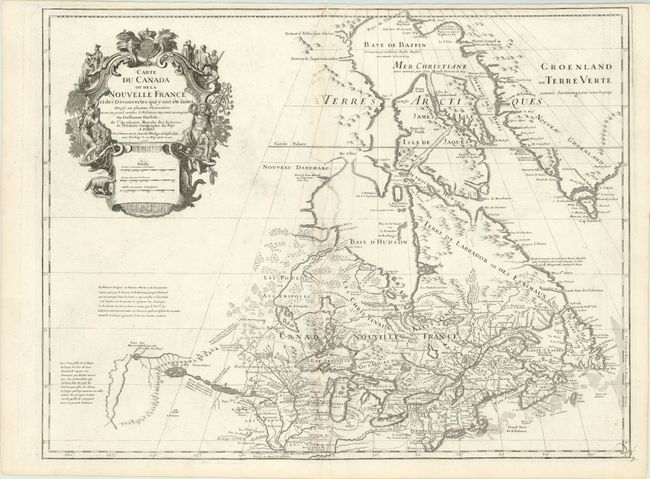
Auction 136, Lot 125
Subject: Colonial United States and Canada
Delisle, Guillaume
Carte du Canada ou de la Nouvelle France et des Decouvertes qui y ont ete faites…, 1718
Size: 25 x 19 inches (63.5 x 48.3 cm)
Estimate: $1,800 - $2,100
One of the most influential maps of Canada, the Great Lakes and Upper Midwest
Sold for: $1,500
Closed on 6/1/2011
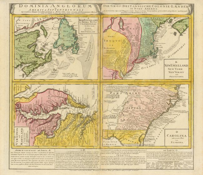
Auction 136, Lot 126
Subject: Colonial United States & Canada
Homann Heirs
Dominia Anglorum in America Septentrionali, 1740
Size: 21.8 x 19.6 inches (55.4 x 49.8 cm)
Estimate: $600 - $800
Sold for: $450
Closed on 6/1/2011
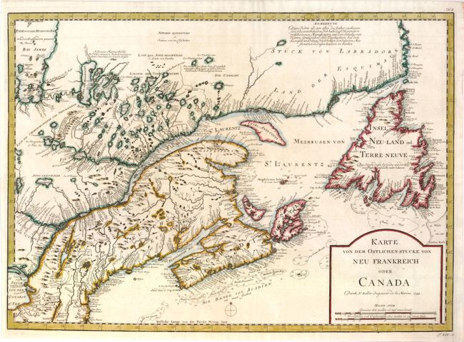
Auction 136, Lot 127
Subject: Colonial United States & Canada
Bellin, Jacques Nicolas
Karte von dem Ostlichen-Stucke von Neu Frankreich oder Canada, 1744
Size: 21.8 x 15.8 inches (55.4 x 40.1 cm)
Estimate: $400 - $500
Unsold
Closed on 6/1/2011
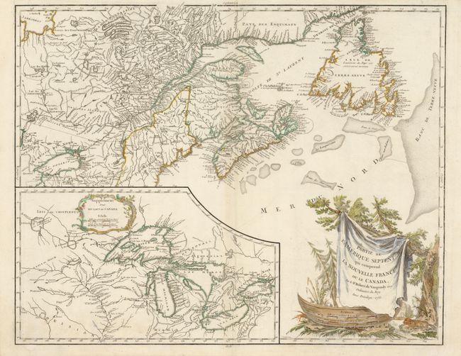
Auction 136, Lot 128
Subject: Colonial United States and Canada
Robert de Vaugondy, Gilles
Partie de l'Amerique Septent? qui comprend la Nouvelle France ou le Canada, 1755
Size: 23.8 x 19 inches (60.5 x 48.3 cm)
Estimate: $600 - $700
Sold for: $450
Closed on 6/1/2011
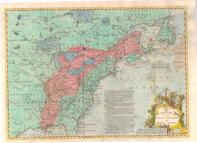
Auction 136, Lot 129
Subject: Colonial United States and Canada
Lodge, John
A Map of the British and French Settlements in North America, 1755
Size: 15.5 x 11 inches (39.4 x 27.9 cm)
Estimate: $350 - $450
Sold for: $250
Closed on 6/1/2011
Auction 136, Lot 130
Subject: Colonial United States and Canada
Spilsbury, J.
A New Map of North America from the Latest Discoveries, 1761
Size: 14.75 x 10.9 inches (37.5 x 27.7 cm)
Estimate: $300 - $375
Unsold
Closed on 6/1/2011
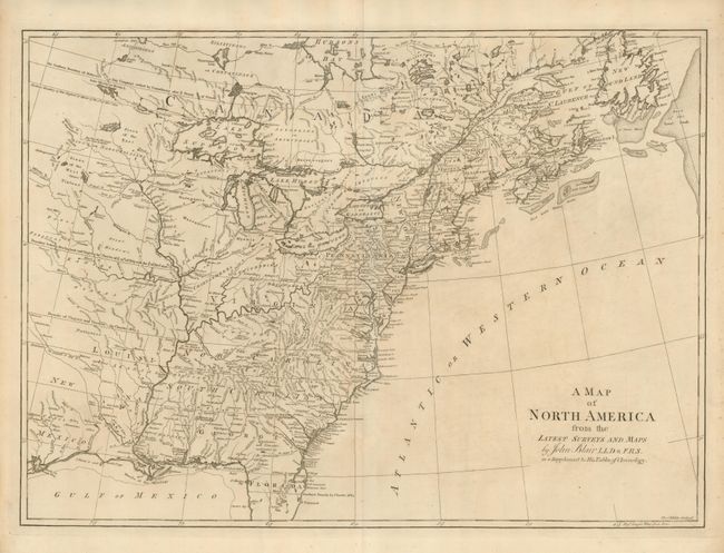
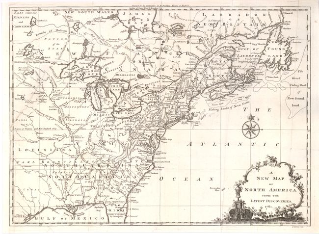
Auction 136, Lot 131
Subject: Colonial United States and Canada
Blair, Rev. John
A Map of North America from the Latest Surveys and Maps, 1768
Size: 22.5 x 16.4 inches (57.2 x 41.7 cm)
Estimate: $850 - $1,000
Unsold
Closed on 6/1/2011
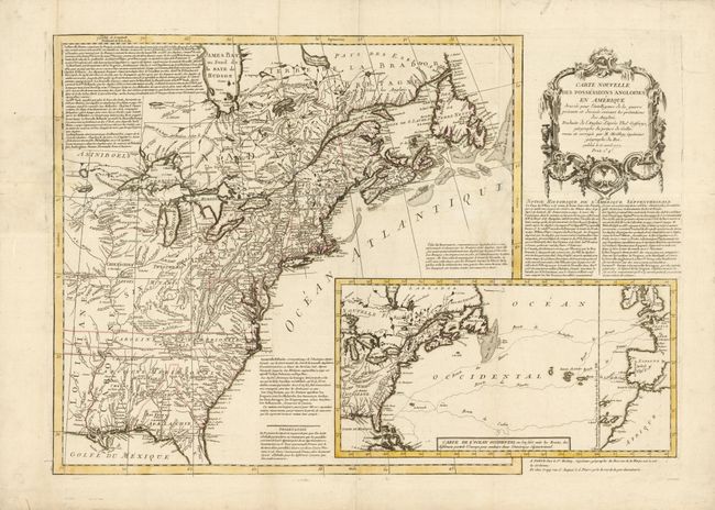
Auction 136, Lot 132
Subject: Colonial United States and Canada
Moithey, Maurille Antoine
Carte Nouvelle des Possessions Angloises en Amerique Dressee pour l'Intelligence de la Guerre Presente et Divisee Suivant les Pretentions des Anglois…, 1777
Size: 27.2 x 19.2 inches (69.1 x 48.8 cm)
Estimate: $2,400 - $3,000
Sold for: $1,500
Closed on 6/1/2011
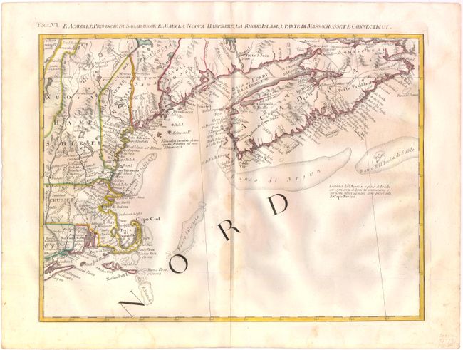
Auction 136, Lot 133
Subject: Colonial United States and Canada
Zatta, Antonio
L'Acadia, le Provincie di Sagadahook e Main, la Nuova Hampshire, la Rhode Island, e Parte di Massachusset e Connecticut, 1778
Size: 16.5 x 12.6 inches (41.9 x 32 cm)
Estimate: $300 - $400
Sold for: $220
Closed on 6/1/2011
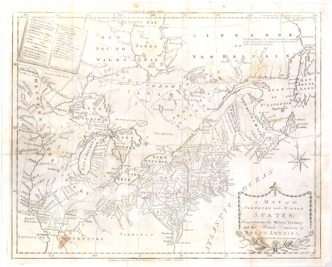
Auction 136, Lot 134
Subject: Canada & United States
Stockdale, John
A Map of the Northern and Middle States; Comprehending the Western Territory and the British Dominions in North America from the Best Authorities, 1793
Size: 15.8 x 12.8 inches (40.1 x 32.5 cm)
Estimate: $500 - $650
Sold for: $375
Closed on 6/1/2011
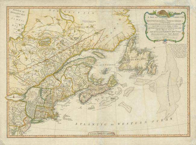
Auction 136, Lot 135
Subject: Canada & United States
Laurie & Whittle
A New and Correct Map of the British Colonies in North America Comprehending Eastern Canada with the Province of Quebec, New Brunswick, Nova Scotia, and the Government of Newfoundland: with the Adjacent States of New England, Vermont, New York…, 1794
Size: 26.4 x 18.6 inches (67.1 x 47.2 cm)
Estimate: $600 - $750
Sold for: $450
Closed on 6/1/2011
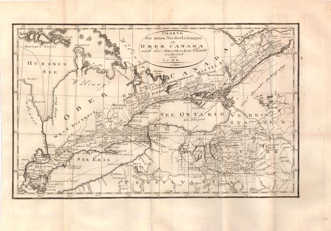
Auction 136, Lot 136
Subject: Canada & United States, Great Lakes
I.C.M.R.
Charte der neuen Niederlassungen in Ober Canada nach der Smythschen Charte, 1800
Size: 12.5 x 7.5 inches (31.8 x 19.1 cm)
Estimate: $200 - $250
Sold for: $150
Closed on 6/1/2011
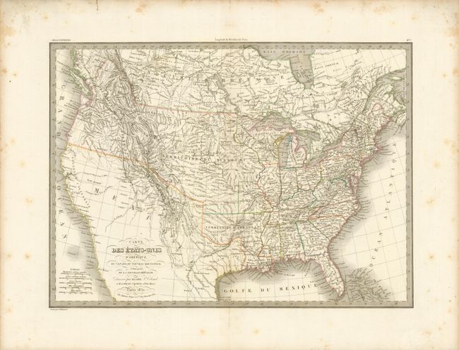
Auction 136, Lot 137
Subject: Canada & United States
Lapie, Alexander Emile & Pierre
Carte des Etats-Unis d'Amerique…, 1832
Size: 21.2 x 15.4 inches (53.8 x 39.1 cm)
Estimate: $375 - $475
Unsold
Closed on 6/1/2011
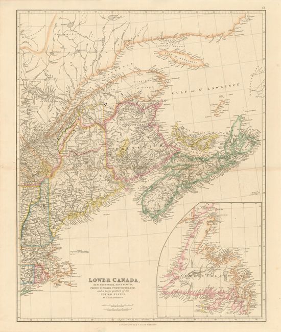
Auction 136, Lot 138
Subject: Canada & United States
Arrowsmith, John
Lower Canada, New Brunswick, Nova Scotia, Prince Edwards Id. Newfoundland, and a large portion of the United States, 1842
Size: 19 x 23.6 inches (48.3 x 59.9 cm)
Estimate: $200 - $250
Sold for: $210
Closed on 6/1/2011
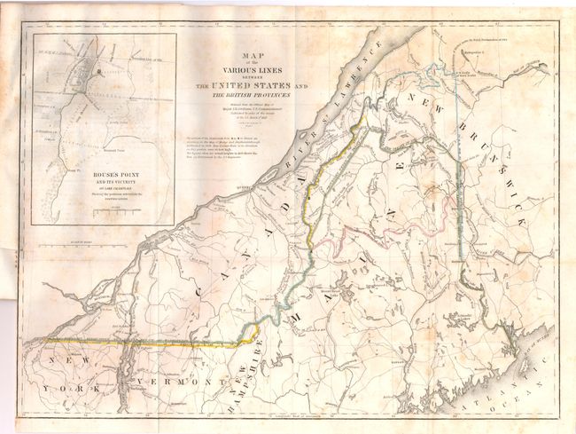
Auction 136, Lot 139
Subject: Canada & New England
Graham, James D.
Map of the Various Lines between the United States and the British Provinces, 1846
Size: 15.5 x 11.8 inches (39.4 x 30 cm)
Estimate: $400 - $600
Sold for: $300
Closed on 6/1/2011
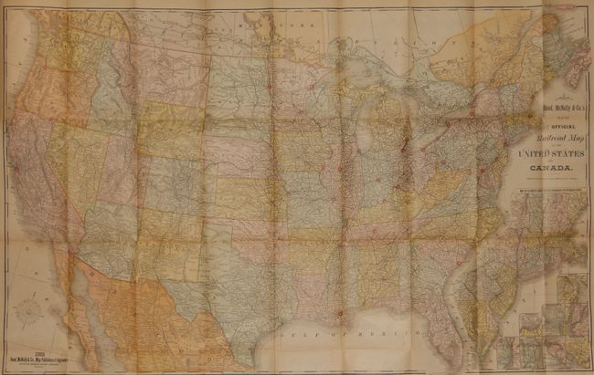
Auction 136, Lot 140
Subject: United States and Canada
Rand McNally & Co.
Official Railroad map of the United States and Canada, 1885
Size: 42.5 x 26.8 inches (108 x 68.1 cm)
Estimate: $140 - $180
Sold for: $170
Closed on 6/1/2011
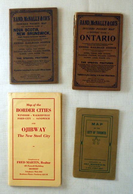
Auction 136, Lot 141
Subject: Canada & United States, Detroit
[Lot of 4 - Pocket Maps of Canada and Detroit], 1902-1920
Size: See Description
Estimate: $120 - $200
Sold for: $110
Closed on 6/1/2011
Auction 136, Lot 142
Subject: Canada & United States
[Lot of 10 - American Cities], 1839-1856
Size: See Description
Estimate: $150 - $180
Sold for: $100
Closed on 6/1/2011
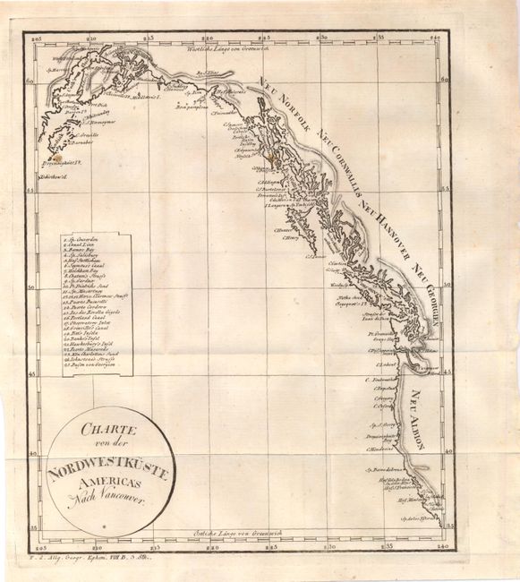
Auction 136, Lot 143
Subject: Western Canada & United States
Anon.
Charte von der Nordwestkuste Americas nach Vancouver, 1804
Size: 8.1 x 10 inches (20.6 x 25.4 cm)
Estimate: $150 - $180
Sold for: $230
Closed on 6/1/2011
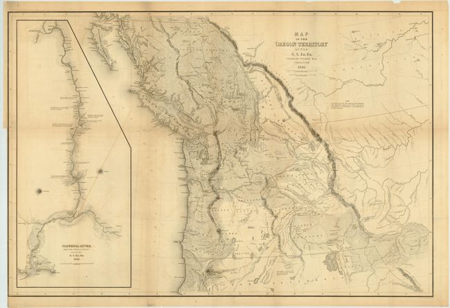
Auction 136, Lot 144
Subject: Western Canada & United States
Wilkes, Charles
Map of the Oregon Territory by the U.S. Ex. Ex., 1841
Size: 34.5 x 22.8 inches (87.6 x 57.9 cm)
Estimate: $1,500 - $2,000
Wilkes' Large-scale Exploring Expedition Map of the Northwest
Sold for: $1,000
Closed on 6/1/2011
Auction 136, Lot 145
Subject: Canada and Alaska
Russell, John C.
British Colonies in North America from the best authorities, 1810
Size: 9 x 7.6 inches (22.9 x 19.3 cm)
Estimate: $140 - $180
Sold for: $50
Closed on 6/1/2011
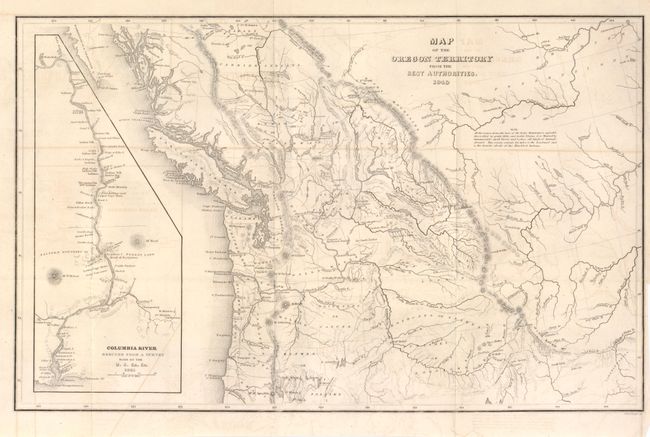
Auction 136, Lot 146
Subject: Northwestern Canada & United States
Wilkes, Charles
Map of the Oregon Territory from the Best Authorities, 1849
Size: 13.2 x 8.3 inches (33.5 x 21.1 cm)
Estimate: $140 - $220
Sold for: $70
Closed on 6/1/2011
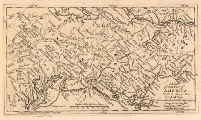
Auction 136, Lot 166
Subject: Colonial United States and Canada
Anon.
A Map of that Part of America, that is now the Seat of War, from Quebeck to Fort Duquesne, comprehending the English Settlement on the Sea Coast, 1758
Size: 7.5 x 4.3 inches (19.1 x 10.9 cm)
Estimate: $400 - $500
Sold for: $250
Closed on 6/1/2011
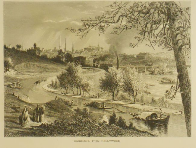
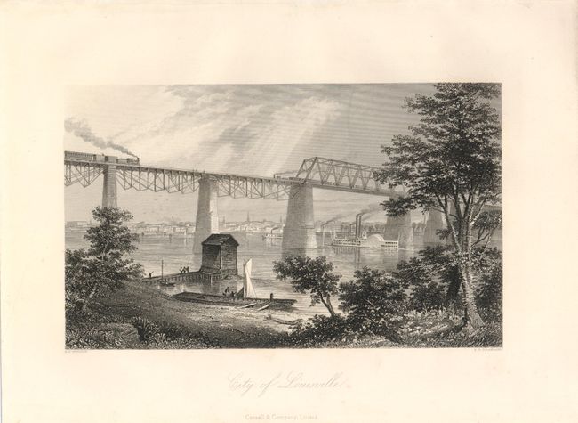
Auction 136, Lot 182
Subject: Eastern United States
Bryant, William C.
Picturesque America; or, the Land we Live in… Volume I [of 4], 1872
Size: 11 x 13 inches (27.9 x 33 cm)
Estimate: $180 - $220
Sold for: $100
Closed on 6/1/2011
39 lots