Subject: Colonial United States and Canada
Period: 1718 (circa)
Publication:
Color: Black & White
Size:
25 x 19 inches
63.5 x 48.3 cm
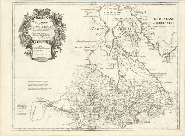
First issued in 1703, this richly detailed map provides the most accurate rendering of the Great Lakes of the time, with the lakes fully enclosed and properly placed in longitude and latitude. Delisle's map of Canada and the Great Lakes is one of the most outstanding and influential maps of the eighteenth century. The Great Lakes are portrayed correctly for the first time, and Detroit marks its debut on this map, only two years after its founding. Delisle's cartography is very meticulous and adds new information from Joliet, Franquelin, and the Jesuit explorers. It correctly positions the Ohio River but confuses its name with the Wabash River. West of the Mississippi Lahontan's fictitious Riviere Longue is prominently depicted. In Canada special attention is given to the rivers and lakes between Hudson Bay and the St. Lawrence, and Lac de Assenipoils (lake Winnipeg) connects to Hudson Bay. Sanson's three islands of the Arctic are retained. Exquisite cartouche with a beaver, natives (one of whom is bearing a scalp), priest and friars, engraved by Guerard. The map remains unchanged from the first edition with et Premier Geographe du Roy added to Delisle imprint.
References: Karpinski p. 118 & 123, Kershaw #312; Tooley (Amer) p. 20 #38 & plt. 10;
Condition: A
A nice impression with some faint offsetting, else fine.