Showing Featured Lots(remove filter)
Catalog Archive
9178 lots
Page 1 of 184
Auction 204, Lot 1
Subject: World
Fries, Lorenz
[Title on Verso] Tabula Moder. Gronlandiae et Russiae, 1525
Size: 18.1 x 11.3 inches (46 x 28.7 cm)
Estimate: $4,000 - $4,750
"Modern" World Map with Portraits of Five Kings
Sold for: $3,000
Closed on 6/18/2025

Auction 204, Lot 2
Subject: World
Gastaldi, Giacomo
Universale Novo, 1548
Size: 6.8 x 5 inches (17.3 x 12.7 cm)
Estimate: $1,900 - $2,200
A "Modern" World Map with North America Connected to Asia
Sold for: $1,800
Closed on 6/18/2025
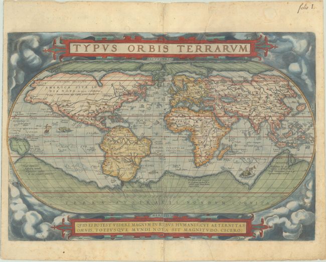
Auction 204, Lot 4
Subject: World
Ortelius, Abraham
Typus Orbis Terrarum, 1581
Size: 19.8 x 13.4 inches (50.3 x 34 cm)
Estimate: $7,000 - $8,500
Ortelius' Famous World Map - First Plate
Sold for: $5,000
Closed on 6/18/2025
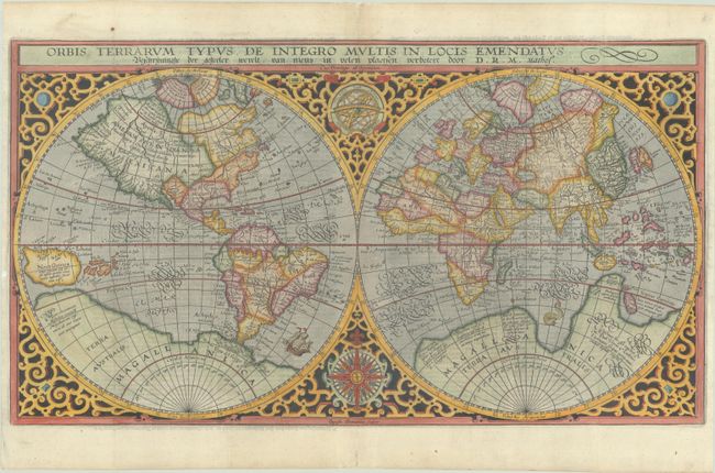
Auction 204, Lot 6
Subject: World
Plancius, Petrus
Orbis Terrarum Typus de Integro Multis in Locis Emendatus..., 1624
Size: 20.2 x 11.3 inches (51.3 x 28.7 cm)
Estimate: $2,750 - $3,500
Plancius' World Map Surrounded by Elegant Strapwork
Sold for: $3,000
Closed on 6/18/2025
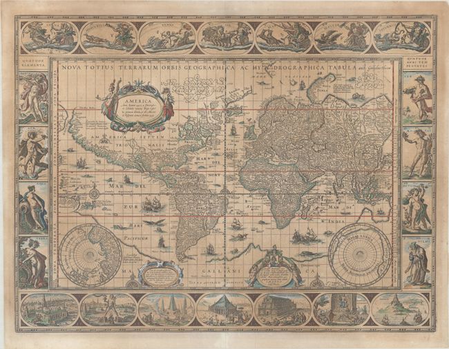
Auction 204, Lot 7
Subject: World
Blaeu, Willem
Nova Totius Terrarum Orbis Geographica ac Hydrographica Tabula, 1635
Size: 21.3 x 16.1 inches (54.1 x 40.9 cm)
Estimate: $8,000 - $9,500
Blaeu's Magnificent Carte-a-Figures World Map
Unsold
Closed on 6/18/2025
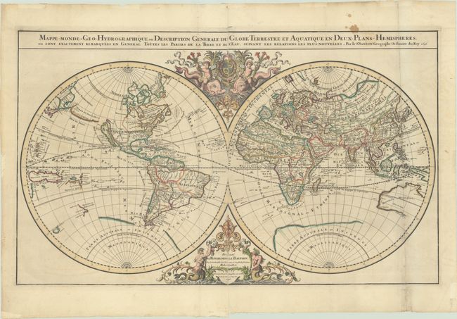
Auction 204, Lot 10
Subject: World
Sanson/Jaillot
Mappe-Monde Geo-Hydrographique, ou Description Generale du Globe Terrestre et Aquatique en Deux-Plans-Hemispheres, ou Sont Exactement Remarquees en General Toutes les Parties de la Terre et de l'Eau, Suivant les Relations les Plus Nouvelles, 1696
Size: 35.3 x 21.3 inches (89.7 x 54.1 cm)
Estimate: $2,200 - $2,500
Jaillot's Grand Double-Hemisphere World Map
Unsold
Closed on 6/18/2025
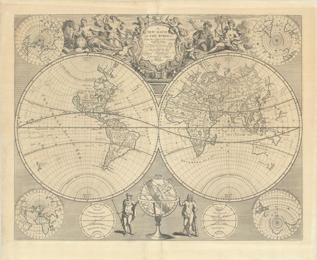
Auction 204, Lot 12
Subject: World
Senex, John
A New Map of the World from the Latest Observations, 1721
Size: 21.4 x 16.8 inches (54.4 x 42.7 cm)
Estimate: $2,400 - $3,000
Double Hemisphere World Map Featuring Both Old and New Cartography
Unsold
Closed on 6/18/2025
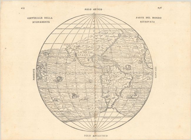
Auction 204, Lot 48
Subject: Western Hemisphere - America
Gastaldi/Ramusio
Universale della Parte del Mondo Nuovamente Ritrovata, 1565
Size: 12 x 11.6 inches (30.5 x 29.5 cm)
Estimate: $3,000 - $3,750
First Printed Map to Reflect Coronado's Explorations in the Southwest
Sold for: $2,000
Closed on 6/18/2025
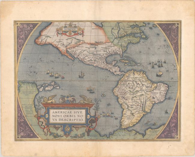
Auction 204, Lot 49
Subject: Western Hemisphere - America
Ortelius, Abraham
Americae sive Novi Orbis, Nova Descriptio, 1587
Size: 19.1 x 13.9 inches (48.5 x 35.3 cm)
Estimate: $5,500 - $6,500
Ortelius' Influential Map of the New World in Full Contemporary Color
Sold for: $3,000
Closed on 6/18/2025
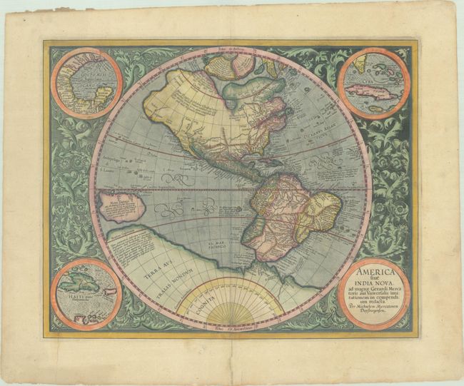
Auction 204, Lot 51
Subject: Western Hemisphere - America
Mercator, Michael
America sive India Nova, ad Magnae Gerardi Mercatoris aui Universalis Imitationem in Compendium Redacta, 1630
Size: 18.2 x 14.5 inches (46.2 x 36.8 cm)
Estimate: $3,250 - $4,000
Mercator's Foundation Map for the Americas in Full Contemporary Color
Sold for: $2,400
Closed on 6/18/2025
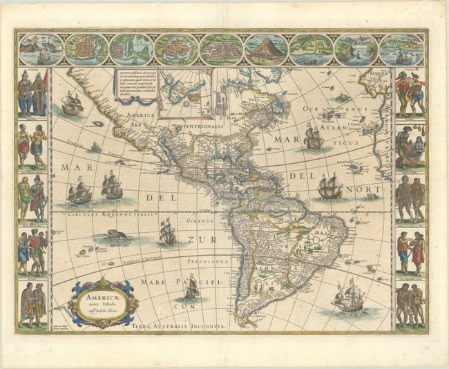
Auction 204, Lot 52
Subject: Western Hemisphere - America
Blaeu, Willem
Americae Nova Tabula, 1642
Size: 21.9 x 16.2 inches (55.6 x 41.1 cm)
Estimate: $4,000 - $4,750
Blaeu's Stunning Carte-a-Figures Map of the Americas
Sold for: $4,000
Closed on 6/18/2025
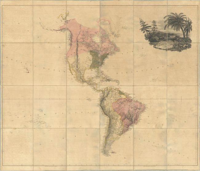
Auction 204, Lot 59
Subject: Western Hemisphere - America
Arrowsmith, Aaron, Sr.
Map of America, 1804
Size: 57.2 x 47.3 inches (145.3 x 120.1 cm)
Estimate: $4,500 - $5,500
First Edition - Full Contemporary Color
Sold for: $3,250
Closed on 6/18/2025
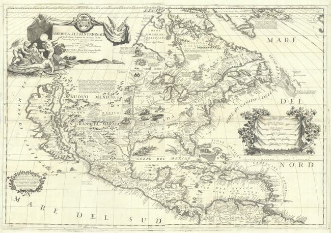
Auction 204, Lot 62
Subject: Colonial North America
Coronelli, Vincenzo Maria
[On 2 Sheets] America Settentrionale colle Nuove Scoperte sin all' Anno 1688 Divisa nelle sue Parti Secondo lo Stato Presente, e Descritta..., 1688
Size: 17.8 x 23.9 inches (45.2 x 60.7 cm)
Estimate: $10,000 - $12,000
Coronelli's Stunning and Influential Map of North America with the Island of California
Sold for: $8,500
Closed on 6/18/2025
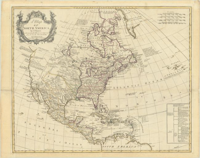
Auction 204, Lot 65
Subject: Colonial North America
Palairet/Delarouchette
A Map of North America, 1763
Size: 22.9 x 18.7 inches (58.2 x 47.5 cm)
Estimate: $2,000 - $2,300
Early Map Depicting Outcome of French & Indian War
Sold for: $1,500
Closed on 6/18/2025
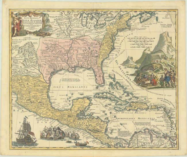
Auction 204, Lot 83
Subject: Colonial Eastern North America & West Indies
Homann, Johann Baptist
Regni Mexicani seu Novae Hispaniae, Ludovicianae, N. Angliae, Carolinae, Virginiae et Pensylvaniae nec non Insularum Archipelagi Mexicani in America Septentrionali Accuata Tabula, 1720
Size: 22.5 x 18.8 inches (57.2 x 47.8 cm)
Estimate: $1,600 - $1,900
Homann's Decorative Map of Colonial America in the Era of the War of the Spanish Succession
Sold for: $1,300
Closed on 6/18/2025
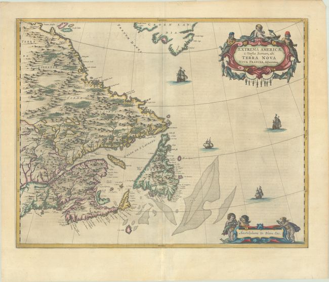
Auction 204, Lot 86
Subject: Eastern Canada
Blaeu, Johannes
Extrema Americae Versus Boream, ubi Terra Nova Nova Francia, Adjacentiaq, 1663
Size: 22.4 x 17.7 inches (56.9 x 45 cm)
Estimate: $1,800 - $2,100
Blaeu's Only Map of Canada, Showing the Canadian Maritimes
Sold for: $1,300
Closed on 6/18/2025
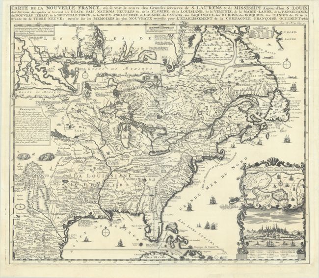
Auction 204, Lot 95
Subject: Colonial Eastern United States & Canada
Chatelain, Henry Abraham
Carte de la Nouvelle France, ou se Voit le Cours des Grandes Rivieres de S. Laurens & de Mississipi Aujour d'hui S. Louis, aux Environs des-quelles se Trouvent les Etats, Pais, Nations, Peuples, &c. de la Floride, de la Louisiane, de la Virginie..., 1719
Size: 19.3 x 16.7 inches (49 x 42.4 cm)
Estimate: $2,200 - $2,500
One of the Most Informative 18th Century Maps of the French Possessions in North America
Unsold
Closed on 6/18/2025
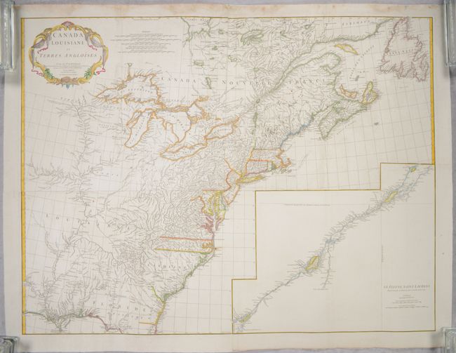
Auction 204, Lot 96
Subject: Colonial Eastern United States & Canada
Anville, Jean Baptiste Bourguignon d'
[On 4 Joined Sheets] Canada Louisiane et Terres Angloises, 1755
Size: 44.8 x 33.9 inches (113.8 x 86.1 cm)
Estimate: $1,400 - $1,700
D'Anville's Spectacular Map of Eastern Seaboard on 4 Joined Sheets
Sold for: $1,000
Closed on 6/18/2025
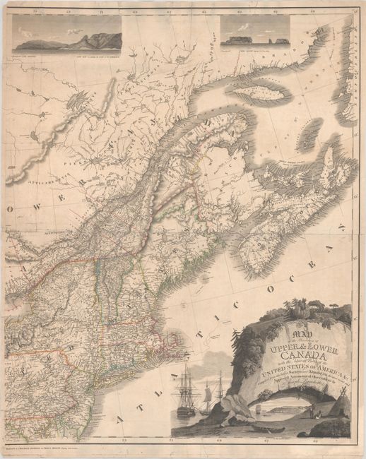
Auction 204, Lot 104
Subject: Northeastern United States & Canada
Bouchette, Joseph
[Eastern Sheet] Map of the Provinces of Upper & Lower Canada with the Adjacent Parts of the United States of America &c. Compiled from the Latest Surveys and Adjusted from the Most Recent and Approved Astronomical Observations, 1815
Size: 24.3 x 30 inches (61.7 x 76.2 cm)
Estimate: $2,400 - $3,000
Eastern Sheet of Bouchette's Rare Map Presenting Lower Canada and New England
Unsold
Closed on 6/18/2025
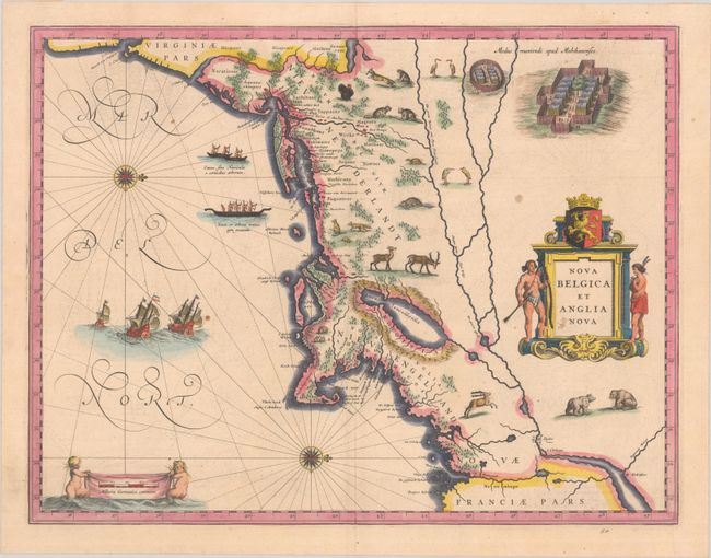
Auction 204, Lot 132
Subject: Colonial New England & Mid-Atlantic United States
Blaeu, (Family)
Nova Belgica et Anglia Nova, 1638
Size: 19.9 x 15.3 inches (50.5 x 38.9 cm)
Estimate: $1,600 - $1,900
Important Map of Colonial New England and the Mid-Atlantic
Unsold
Closed on 6/18/2025
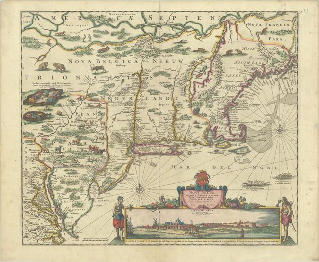
Auction 204, Lot 133
Subject: Colonial New England & Mid-Atlantic United States
Danckerts, Justus
Novi Belgii Novaeque Angliae nec non Pennsylvaniae et Partis Virginiae Tabula Multis in Locis Emendata, 1690
Size: 21.4 x 18.2 inches (54.4 x 46.2 cm)
Estimate: $4,000 - $4,750
Danckerts' Decorative Map with Early View of New York City in Full Contemporary Color
Sold for: $3,000
Closed on 6/18/2025
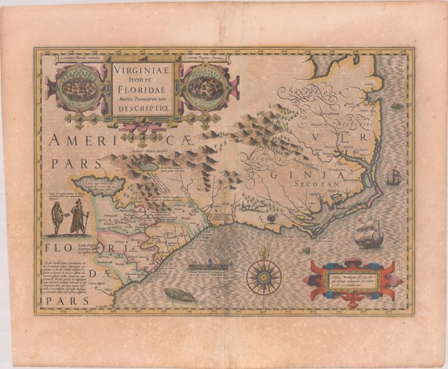
Auction 204, Lot 141
Subject: Colonial Southeastern United States
Hondius, Jodocus
Virginiae Item et Floridae Americae Provinciarum, Nova Descriptio, 1619
Size: 19.1 x 13.5 inches (48.5 x 34.3 cm)
Estimate: $1,400 - $1,700
A Seminal Map of the Southeast and Early American Cartography in Full Contemporary Color
Unsold
Closed on 6/18/2025
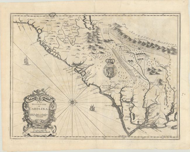
Auction 204, Lot 143
Subject: Colonial Southeastern United States
Speed/Lamb
A New Description of Carolina, 1676
Size: 19.8 x 14.8 inches (50.3 x 37.6 cm)
Estimate: $1,800 - $2,100
Speed's Map of the Carolinas Based Upon the Lords Proprietor's Map
Sold for: $650
Closed on 6/18/2025
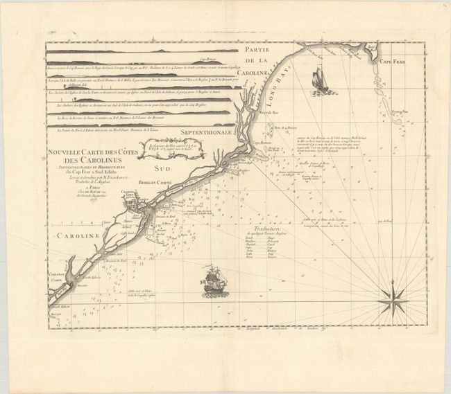
Auction 204, Lot 146
Subject: Colonial Southeastern United States
Le Rouge, George Louis
Nouvelle Carte des Cotes des Carolines Septentrionales et Meridionales du Cap Fear a Sud Edisto..., 1777
Size: 21.3 x 16.1 inches (54.1 x 40.9 cm)
Estimate: $1,000 - $1,300
Rare French Chart of the Carolina Coast
Sold for: $375
Closed on 6/18/2025
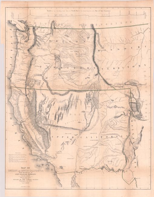
Auction 204, Lot 155
Subject: Western United States
Fremont/Preuss
[Map with Report] Map of Oregon and Upper California from the Surveys of John Charles Fremont and Other Authorities [with] Geographical Memoir upon Upper California..., 1849
Size: 26.7 x 33.3 inches (67.8 x 84.6 cm)
Estimate: $1,500 - $1,800
Fremont's Map of the American West with Report
Sold for: $1,100
Closed on 6/18/2025
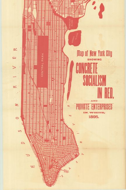
Auction 204, Lot 226
Subject: New York City, New York
Map of New York City Showing Concrete Socialism in Red, and Private Enterprises in White, 1895
Size: 13 x 39 inches (33 x 99.1 cm)
Estimate: $400 - $600
"A Powerful Example of Color Used to Make a Point" - PJ Mode
Sold for: $250
Closed on 6/18/2025
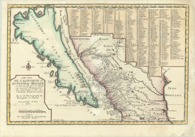
Auction 204, Lot 255
Subject: Southwestern United States & Mexico, California
Fer, Nicolas de
Cette Carte de Californie et du Nouveau Mexique, est Tiree de Celle qui a ete Envoyee par un Grand d'Espagne pour etre Communiquee a Mrs. de l'Academie Royale des Sciences, 1700
Size: 13.4 x 9 inches (34 x 22.9 cm)
Estimate: $1,100 - $1,400
De Fer's Important Map of the Island of California - First State
Sold for: $800
Closed on 6/18/2025
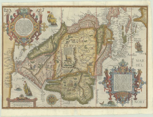
Auction 204, Lot 290
Subject: South America & Caribbean
Linschoten/Langren
Delineatio Omnium Orarum Totius Australis Partis Americae, Dictae Peruvianae, a R. de la Plata, Brasiliam, Pariam, & Castellam Auream..., 1596
Size: 21.3 x 15.1 inches (54.1 x 38.4 cm)
Estimate: $7,000 - $8,500
One of the Most Decorative Early Maps of South America
Sold for: $4,000
Closed on 6/18/2025
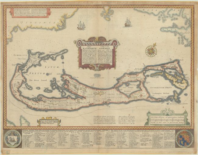
Auction 204, Lot 319
Subject: Bermuda
Speed, John
Mappa Aestivarum Insularum Alias Bermudas Dictarum... / A Mapp of the Sommer Islands Once Called the Bermudas..., 1676
Size: 21.1 x 15.9 inches (53.6 x 40.4 cm)
Estimate: $1,200 - $1,500
Speed's Foundation Map of Bermuda
Unsold
Closed on 6/18/2025

Auction 204, Lot 335
Subject: Western England
Saxton, Christopher
Salopiae Comitatus, Summa cum Fide, Cura et Diligentia Descriptionem haec Tibi Tabula Refert, 1577
Size: 19.9 x 15.4 inches (50.5 x 39.1 cm)
Estimate: $1,600 - $1,900
Scarce Map from Saxton's First National Atlas in Full Contemporary Color
Sold for: $1,200
Closed on 6/18/2025
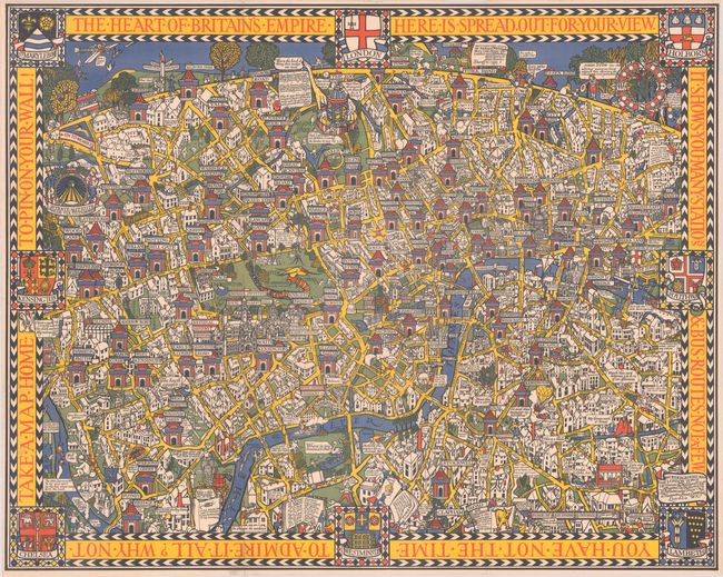
Auction 204, Lot 347
Subject: London, England
Gill, MacDonald
The Wonderground Map of London Town, 1914
Size: 36.8 x 29.2 inches (93.5 x 74.2 cm)
Estimate: $1,800 - $2,100
British Empire Exhibition Edition of MacDonald Gill's Landmark "Wonderground Map" of London
Sold for: $1,500
Closed on 6/18/2025
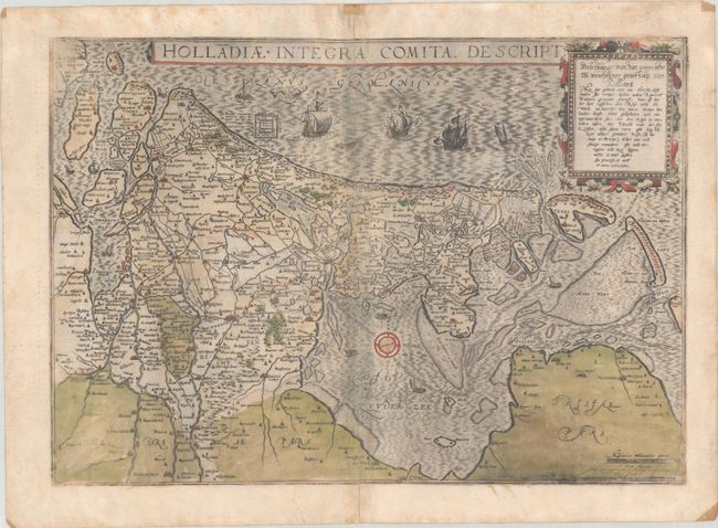
Auction 204, Lot 389
Subject: Netherlands
Jode, Cornelis de
Holladiae Integra Comita Descript., 1593
Size: 18.9 x 13.3 inches (48 x 33.8 cm)
Estimate: $1,100 - $1,400
Rare Map of Netherlands in Full Contemporary Color
Unsold
Closed on 6/18/2025
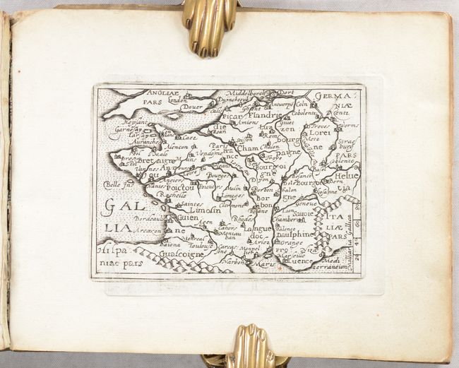
Auction 204, Lot 410
Subject: France, Atlas
Quad, Matthias von Kinckelbach
Deliciae Galliae sive Itinerarium per Universam Galliam..., 1603
Size: 7.8 x 6.1 inches (19.8 x 15.5 cm)
Estimate: $1,000 - $1,300
Rare Atlas with 32 Miniature Maps Based on Ortelius
Sold for: $750
Closed on 6/18/2025
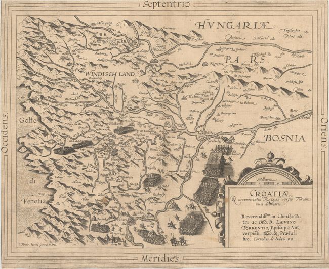
Auction 204, Lot 510
Subject: Croatia
Jode, Cornelis de
Croatiae, & Circumiacentiu Regionu Versus Turcam Nova Delineatio, 1593
Size: 15.6 x 12.9 inches (39.6 x 32.8 cm)
Estimate: $800 - $950
Rare Map of Croatia During Long Turkish War
Sold for: $600
Closed on 6/18/2025
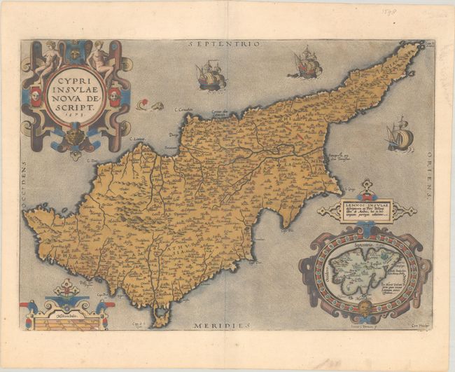
Auction 204, Lot 539
Subject: Cyprus
Ortelius, Abraham
Cypri Insulae Nova Descript., 1573
Size: 19.8 x 13.9 inches (50.3 x 35.3 cm)
Estimate: $1,100 - $1,400
Superb, Decorative Map of Cyprus in Full Contemporary Color
Unsold
Closed on 6/18/2025
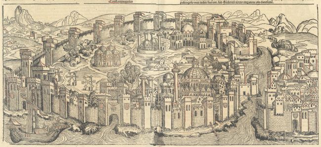
Auction 204, Lot 556
Subject: Istanbul, Turkey
Schedel, Hartmann
Folium CXXX - Constantinopolis, 1493
Size: 20.9 x 9.4 inches (53.1 x 23.9 cm)
Estimate: $1,400 - $1,700
One of the Earliest Available Views of Constantinople, from Schedel's Nuremberg Chronicle
Unsold
Closed on 6/18/2025
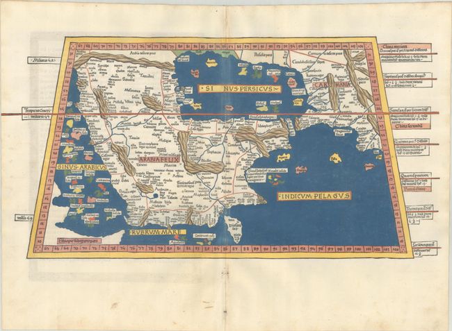
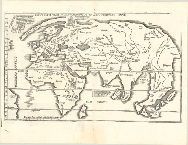
Auction 204, Lot 567
Subject: Arabia
Ptolemy/Holle
[Title on Verso] Sexta Asie Tabula Continet Arabiam Felicem..., 1482
Size: 22.3 x 11.3 inches (56.6 x 28.7 cm)
Estimate: $55,000 - $65,000
One of the Earliest & Most Desirable Printed Maps of Arabia
Unsold
Closed on 6/18/2025
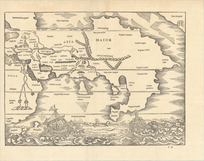
Auction 204, Lot 573
Subject: Asia
Solinus, Caius Julius
[Asia Maior], 1538
Size: 13 x 9.7 inches (33 x 24.6 cm)
Estimate: $2,000 - $2,300
Earliest Depiction of the Northwest Coast of America on a Printed Map
Unsold
Closed on 6/18/2025
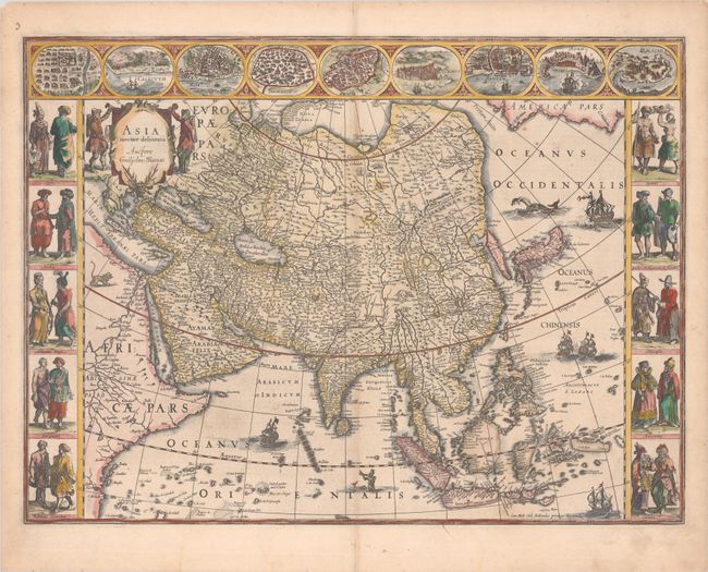
Auction 204, Lot 577
Subject: Asia
Blaeu, Willem
Asia Noviter Delineata, 1634
Size: 22 x 16.3 inches (55.9 x 41.4 cm)
Estimate: $3,000 - $3,750
Magnificent Carte-a-Figures Map of Asia
Sold for: $2,000
Closed on 6/18/2025
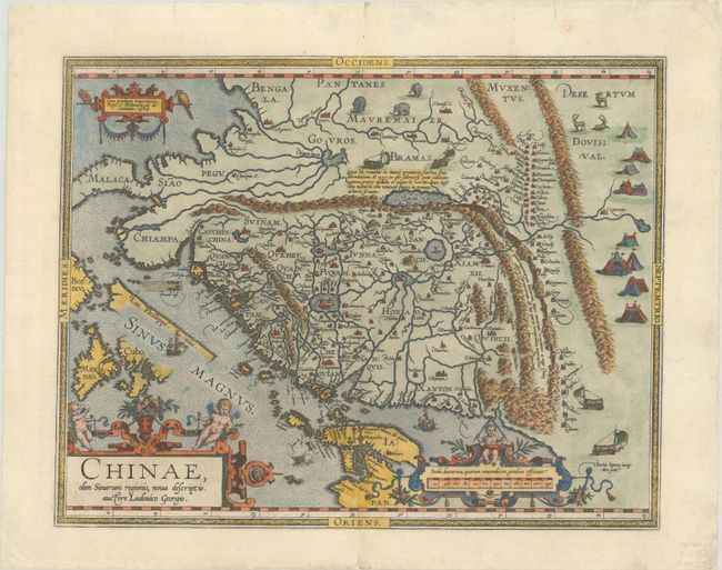
Auction 204, Lot 589
Subject: China
Ortelius, Abraham
Chinae, olim Sinarum Regionis, Nova Descriptio. Auctore Ludovico Georgio, 1584
Size: 18.5 x 14.5 inches (47 x 36.8 cm)
Estimate: $4,000 - $5,000
The First European-Printed Map of China
Unsold
Closed on 6/18/2025
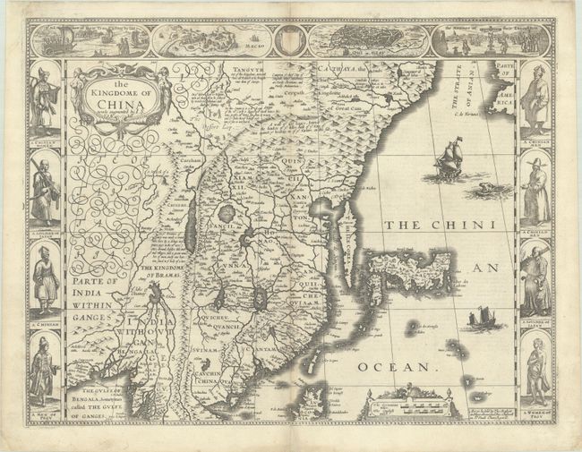
Auction 204, Lot 594
Subject: China, Korea & Japan
Speed, John
The Kingdome of China Newly Augmented, 1626
Size: 20.3 x 15.6 inches (51.6 x 39.6 cm)
Estimate: $3,000 - $3,750
Speed's Striking Carte-a-Figures Map of China with the Island of Korea
Unsold
Closed on 6/18/2025
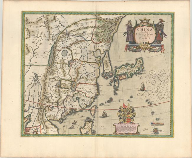
Auction 204, Lot 595
Subject: China, Korea & Japan
Blaeu, (Family)
China Veteribus Sinarum Regio nunc Incolis Tame Dicta, 1640
Size: 19.6 x 16.1 inches (49.8 x 40.9 cm)
Estimate: $1,100 - $1,400
Attractive Example of Blaeu's Map of China Featuring Fictitious Lakes and Rivers
Sold for: $700
Closed on 6/18/2025
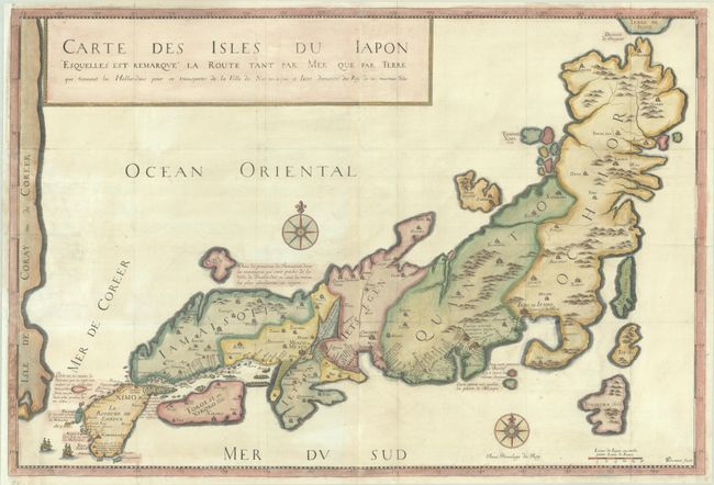
Auction 204, Lot 601
Subject: Japan
Tavernier, Jean Baptiste
Carte des Isles du Iapon Esquelles est Remarque la Route tant par Mer que par Terre que Tiennent les Hollandois pour se Transporter de la Ville de Nangasaqui a Iedo..., 1679
Size: 30.4 x 20.5 inches (77.2 x 52.1 cm)
Estimate: $800 - $1,000
Rare, First Edition Map of Japan
Sold for: $600
Closed on 6/18/2025
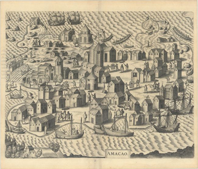
Auction 204, Lot 608
Subject: East Indies - Indonesia, Singapore, & Macao
Bry, Johann Theodore de
[Petits Voyages, Part VIII] Achter Theil der Orientalischen Indien / Begreiffend Erstlich ein Historische Beschreibung der Schiffart..., 1606
Size: 7.8 x 11.8 inches (19.8 x 30 cm)
Estimate: $2,750 - $3,500
Complete Disbound Example of Petits Voyages, Part VIII, with Map of Strait of Singapore and Plan of Macao
Sold for: $2,000
Closed on 6/18/2025
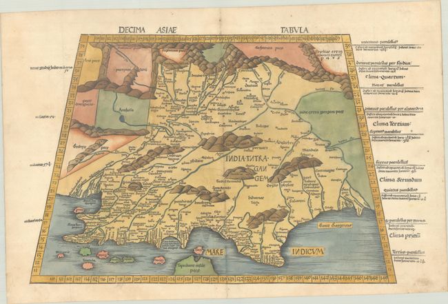
Auction 204, Lot 610
Subject: India
Ptolemy/Waldseemuller
Decima Asiae Tabula, 1513
Size: 22.3 x 14 inches (56.6 x 35.6 cm)
Estimate: $2,000 - $2,300
Early Ptolemaic Map of India
Sold for: $1,200
Closed on 6/18/2025
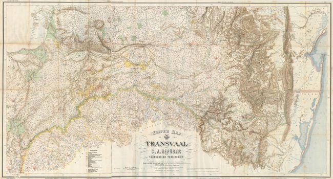
Auction 204, Lot 636
Subject: South Africa
Stanford, Edward
[Lot of 3 - Sheets 4, 5 & 6] Jeppe's Map of the Transvaal or S.A. Republic and Surrounding Territories..., 1899
Size: 25.4 x 37.8 inches (64.5 x 96 cm)
Estimate: $600 - $750
Important Maps of South Africa Published Just Prior to Second Boer War
Unsold
Closed on 6/18/2025
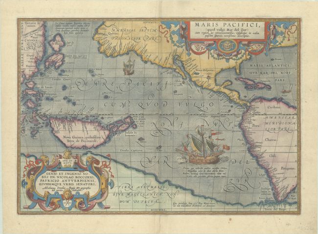
Auction 204, Lot 637
Subject: Pacific Ocean, Western Hemisphere
Ortelius, Abraham
Maris Pacifici, (quod Vulgo Mar del Zur) cum Regionibus Circumiacentibus, Insulisque in Eodem Passim Sparsis, Novissima Descriptio, 1589
Size: 19.5 x 13.6 inches (49.5 x 34.5 cm)
Estimate: $7,500 - $8,500
The First Printed Map Devoted to the Pacific
Sold for: $5,500
Closed on 6/18/2025
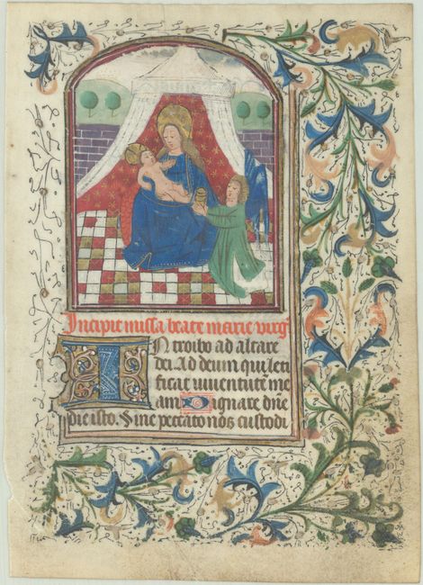
Auction 204, Lot 667
Subject: Medieval Manuscripts
Anon.
[Illuminated Manuscript], 1450
Size: 5 x 6.9 inches (12.7 x 17.5 cm)
Estimate: $1,900 - $2,200
Superb Image of Mary and Baby Jesus in Contemporary Hand Color with Gilt Highlights
Unsold
Closed on 6/18/2025
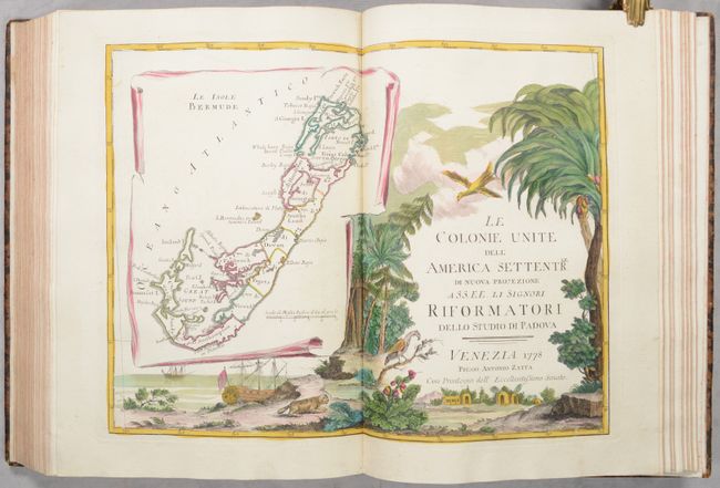
Auction 204, Lot 681
Subject: Atlases
Zatta, Antonio
[4 Volumes in 2 Books] Atlante Novissimo Tomo I-IV, 1779
Size: 11.2 x 15.5 inches (28.4 x 39.4 cm)
Estimate: $27,500 - $35,000
Zatta's Complete Atlas with 218 Maps in Full Contemporary Color
Sold for: $20,000
Closed on 6/18/2025
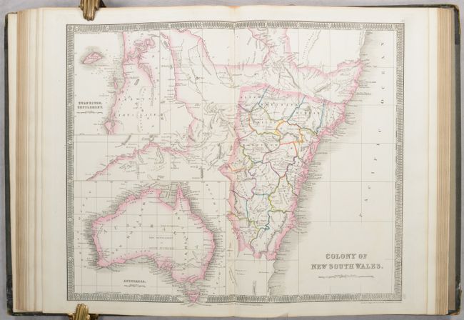
Auction 204, Lot 684
Subject: Atlases
Teesdale, Henry
A New General Atlas of the World, Compiled from the Latest Authorities Borth English & Foreign, Containing Separate Maps of Its Various Countries & States..., 1838
Size: 10.6 x 15 inches (26.9 x 38.1 cm)
Estimate: $1,400 - $1,700
Teesdale's Fine Atlas Featuring Detailed Maps of India, Australia and the Americas
Sold for: $1,800
Closed on 6/18/2025
9178 lots
Page 1 of 184