Subject: Asia
Period: 1538 (published)
Publication: C. Iulii Solini Polyhistor, Rerum Toto Orbe Memorabilium Thesaurus Locupletissimus...
Color: Black & White
Size:
13 x 9.7 inches
33 x 24.6 cm
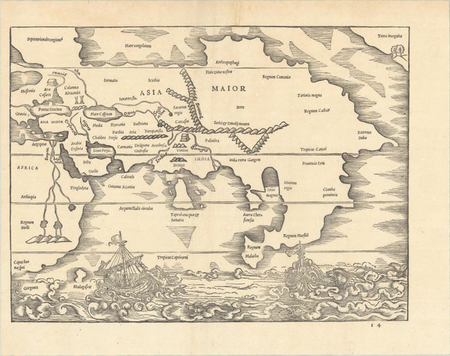
This rare woodblock map is one of the first obtainable maps to focus on the continent of Asia as well as the first printed map to depict the northwest coast of America. It appeared in Caius Julius Solinus' Polyhistor, a geographical description of the world. Solinus was a Roman grammarian from the 3rd century who borrowed largely from Pliny's Natural History, reinterpreting it from a geographical perspective. The map is typically attributed to Sebastian Munster, who edited the text of Solinus's ancient geography, two years before publishing his edition of Ptolemy and six years before his Cosmographia.
The double-page map shows the northwest coast of America as Terra Incognita, which appears in the top right corner with a bay, two trees, and a mountain. Referring to this unknown land, Solinus's text reads, "In our days it has been explored by men," indicating the possibility of an unrecorded early expedition to America. The landmass is separated from Asia by a straight - the first such delineation between Asia and America, appearing 200 years before Vitus Bering's voyage to the northern Pacific. Its early depiction of Asia presents India and Sri Lanka in reverse proportion to one another, as is typical on Ptolemaic maps. This depiction is outdated, as India had already been shown with a correct shape and proportion in world maps by Ruysch circa 1508 and Waldseemuller in 1513. Another oddity is the giant eastern peninsula that extends south of the Tropic of Cancer with Regnum Malacha (Malacca) at the tip, a remnant of Ptolemy's belief in a landlocked Indian Ocean. The map extends to include part of Africa, with a Ptolemaic depiction of the origin of the Nile. Along the bottom of the map is a fantastical maritime scene of two ships being attacked by mythical sea creatures. This is the first of two states, with the signature "t 4" at bottom right.
References: Burden #11; Mickwitz & Miekkavaara #285-14; Yeo #1.
Condition: A
Issued folding, now flat, with a short archivally repaired fold separation and minor stain confined to the top blank margin.