Subject: Japan
Period: 1679 (circa)
Publication:
Color: Hand Color
Size:
30.4 x 20.5 inches
77.2 x 52.1 cm
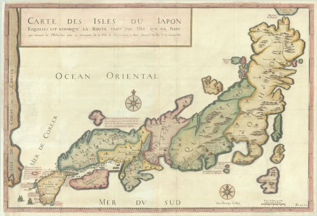
Jean Baptiste Tavernier (1605-1689) was a famous French merchant whose travels pioneered trade with India and the Orient, the subject of which serves as the bulk of his writings. This large map of Japan appeared in Recueil de Plusieurs Relations et Traitez Singuliers et Curieux, which was alternatively titled Suite des Voyages de Mr Tavernier. This larger edition map only appeared in editions of Tavernier's work between 1679-82, while later editions included a much smaller copy of the map (measuring approximately 12 x 8"). As a result, the large edition of this map is quite rare.
Tavernier had not actually visited Japan, but compiled his map from reports gathered during his travels. The map is presented in the style of the Blancus/Moreira maps with eastern Japan being more pronounced than western Japan and an ungainly form of Honshu. The coast of Korea, noted as an island, forms the western edge of the map, and the sea between Korea and Japan is labeled Mer De Coreer (Sea of Korea). The route of the Dutch East India Company from Nagasaki to Edo is noted in the title and shown on the map, and Tavernier's famous notations are included. The handsome map is decorated with a pair of ships at bottom left and two compass roses. Engraved by Durant (likely Jean-Louis Durant). Printed on two sheets, joined as issued.
References: Hubbard #43; Walter, OAG #40.
Condition: B+
A nice impression, issued folding on bright, watermarked sheets with very light toning and offsetting. A large chip at left has been professionally reattached.