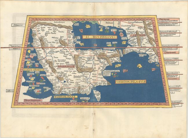
Subject: Arabia
Period: 1482 (published)
Publication: Claudii Ptolomei viri Alexandrini Cosmographie Octavus et Ultimus Liber Explicit
Color: Hand Color
Size:
22.3 x 11.3 inches
56.6 x 28.7 cm
Claudius Ptolemy was a mathematician, astronomer and geographer who worked in Alexandria, then a part of the Roman Empire, in the 2nd century AD. One of the most learned and influential men of his time, his theories dominated both astronomy and geography for nearly 1500 years. His writings were kept alive by Arabic scholars during the Middle Ages and reemerged in Europe during the Renaissance. The birth of printing led to wide dissemination of his great works on astronomy and geography. There were a number of editions of his Geographia beginning in 1477. These early editions contained maps based on his original writings, known as Ptolemaic maps. As geographic knowledge increased with the explorations of Columbus, Magellan, Cabot and others, maps of the New World were added, and maps of the Old World were revised. Ptolemy's Geographia continued to be revised and published by some of the most important cartographers including Martin Waldseemuller, Sebastian Munster, Giacomo Gastaldi, Jodocus Hondius, and Gerard Mercator (whose last edition was published in 1730).
This rare woodcut map of Arabia was published in the 1482 Ulm edition of Ptolemy's Cosmographia. The 1482 edition is notable for several reasons: is was the first edition with woodcut maps; it was the first edition to be printed outside of Italy; and it was the first to have related text printed on the verso of the maps. This edition was printed by Leinhart Holle with text that was based on a Latin translation by Jacobus Angelus and edited by Nicolaus Germanus, a Benedictine monk and cartographer. In addition to editing Jacobus Angelus' translation, Nicolaus Germanus also corrected and improved the maps. It is believed that the maps were engraved by Johannes, an engraver from Armsheim, as his imprint appears on the world map. Leinhart Holle went bankrupt shortly after the publication and sold the blocks to Johann Reger, who printed a second edition in 1486. The two editions are distinguishable as titles were added to the majority of the maps on recto, whereas the titles only appear on verso in the 1482 edition. In addition, the 1482 edition is identifiable due to the coloring of the maps, on which the seas were colored in a vibrant blue made from Lapis Lazuli; in the 1486 edition, the seas were colored brown.
Cartographically, the map is filled with ancient place names and exaggerated mountain ranges, largely based on ancient Greek sources. The Persian Gulf is rectangularly-shaped and the islands surrounding the Arabian Peninsula are oversized. One of the earliest and most desirable maps of Arabia available to collectors.
References: Mickwitz & Miekkavaara #199-26; Nordenskiold (Facsimile Atlas) pp. 14-16; Tibbetts #8.
Condition: A
Superb impression and full contemporary color on a bright sheet with minor marginal soiling. The color along the centerfold is a bit faded with some small abrasions.