Subject: Colonial North America
Period: 1688 (dated)
Publication: Atlante Veneto
Color: Black & White
Size:
17.8 x 23.9 inches
45.2 x 60.7 cm
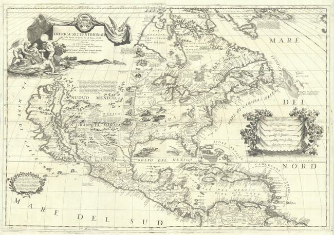
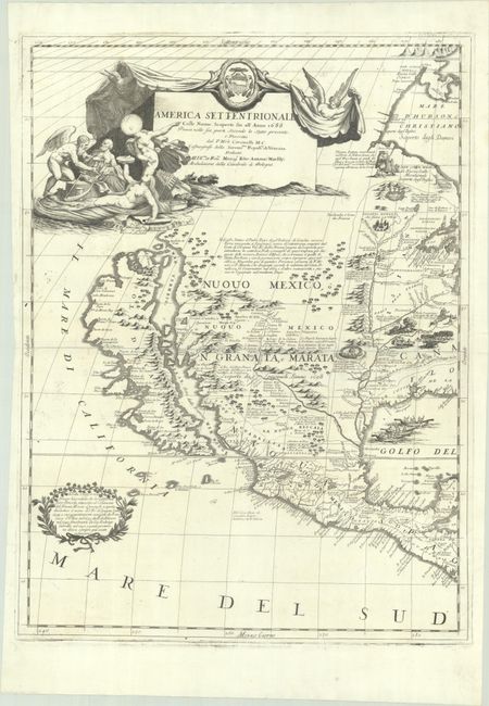
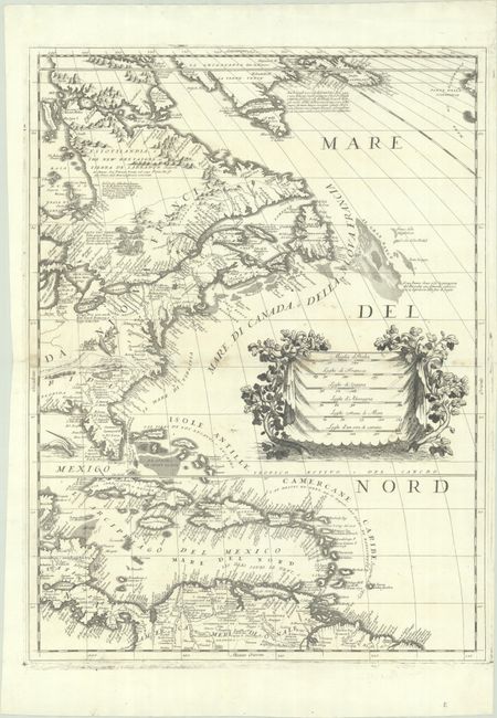
This exquisitely engraved map of the continent is one of Coronelli's most impressive achievements, showcasing both his scientific rigor and impeccable aesthetic sense, along with some striking cartographic misconceptions. The most noticeable of these misconceptions is the appearance of the island of California in the Foxe configuration with indented bays in the northern coastline as well as a mountain range that runs along its eastern coast. To the southwest of the island, Italian text in a garlanded cartouche references the possibility that California may be a peninsula. The map also depicts the Mississippi River emptying into the Gulf of Mexico 600 miles too far to the west, a cartographic error based on La Salle. As the royal cosmographer of the Republic of Venice and a favorite of Louis XIV of France, Coronelli had access to court documents featuring accounts of the latest expeditions, including the manuscripts of La Salle. Teguiao and Quivira are located around some mountains to the north of Taos. The spurious Lake May is prominently shown in the southeast. There is an extraneous peninsula in New England.
Aside from these cartographic myths, the map features some of the most up-to-date cartography of its era. The cartography of the Great Lakes draws from the accounts of Louis Jolliet, Jacques Marquette, and Louis Hennepin, and, as a result, it is the most precise mapping of the region yet. Whereas other cartographers of the era presented the Rio Grande terminating in the Gulf of California, Coronelli draws from the accounts of Diego Dionisio de Penalosa Briceno y Berdugo and accurately shows it exiting into the Gulf of Mexico. He divides the river into the Rio Norte and Rio Bravo.
The landscape is filled with notes on various expeditions and small exaggerated illustrations of Indigenous life, including an alligator attack, a cannibals' feast, and a few village views. Sea monsters and natives in canoes appear in the Gulf of Mexico. There is a large decorative title cartouche at top left featuring allegorical figures and symbols related to exploration in the New World. Another large cartouche enclosing six distance scales appears in the Atlantic. The map is dedicated to Marsili, Archbishop of Bologna.
References: Burden #643; McLaughlin #103; Shirley (BL Atlases) T.CORO-7a #12 & 13; Tooley (America), p. 125, #57; Wheat (TMW) #70.
Condition: A
Sharp impressions on bright sheets with professional repairs to some tiny worm holes and tracks along the centerfolds, with a bit of minor soiling along the centerfold on the eastern sheet. There are a few tiny tears along the edges of the sheet. The first image is a composite image - the map is in 2 separate sheets.