Subject: Western Hemisphere - America
Period: 1804 (dated)
Publication:
Color: Hand Color
Size:
57.2 x 47.3 inches
145.3 x 120.1 cm
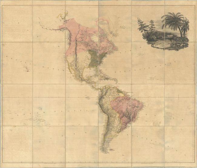
This is the first edition of Arrowsmith's epic map of the Western Hemisphere, with the publisher's imprint at No. 24 Rathbone Place in London. The map was issued a year after the completion of the Louisiana Purchase, and presents limited details to the west of the Mississippi River. These vast western regions would subsequently be explored by the likes of Humboldt, Pike, Lewis & Clark, and many others thus filling the map over time with cartographic knowledge. To the east of the Mississippi, states, cities and towns, courthouses, and forts are named. Beyond the Mississippi, the Missouri River heads too far to the north up to both a "Pawnee Village" and "Villages of the Tall Indians and Manders." Dotted lines extend west from these villages and indicate possible courses of the Missouri River. To the west of the Rocky Mountains, a group of three rivers are noted as possibly joining the Columbia to the Pacific Ocean (Lewis & Clark would answer this in short time). In the Southwest, numerous villages are located along the upper Rio Grande including Santa Fe, S. Juan and S. Geronimo. Other than the missions along the California coast, the West is nearly blank. Along the Northwest coast, the map reflects the discoveries of Cook, Vancouver and La Perouse while the discoveries of Mackenzie (1789) and Hearne (1771) are noted along the Icy Sea. The map extends to the Sandwich Islands in the Pacific Ocean and notes "where Capt. Cook was Killed 1779." In South America, Arrowsmith presents remarkable detail of the river systems, mountain ranges, and coastal place names though he still identifies the fictitious Lago Parimi (Lake Parime) in the north. The map is decorated by a large title cartouche engraved by W&G Cooke featuring a pair of moose and squirrels along the coast surrounded by vegetation. Dissected into 24 panels and backed with contemporary linen. The map has been stored in a leather folder with gilt decorations.
References: Stevens & Tree #1(a).
Condition: B
Full contemporary color on a lightly toned sheet with scattered foxing and some light staining. Dissected and backed with contemporary linen. Ribbon edging is only partial and is fraying along the edges. A former owner's stamp is on verso. There are some small gray areas, particularly in the lower half of the map, that are caused by our scanner and are not present on the physical map. Accompanying leather folder is lightly worn with some minor staining on the back cover.