Subject: World
Period: 1696 (dated)
Publication:
Color: Hand Color
Size:
35.3 x 21.3 inches
89.7 x 54.1 cm
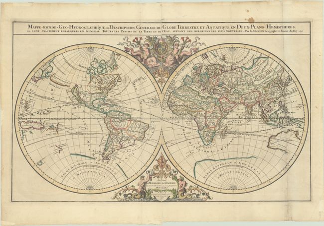
This beautiful double-hemisphere map by Nicolas Sanson was reworked by his sons Guillaume (1633-1703) and Adrian (1639-1718) and published in 1696 by Alexis-Hubert Jaillot. The map displays some interesting cartographic myths such as California as an island and a large Terre de Iesso. In addition, the northwestern coast of North America is largely blank and the Great Lakes are in early formation. The mythical lakes Lac Parime and Lac Xarayes are depicted in South America. A partial outline of the great southern continent, Terre Australe et Inconnue, still appears, and there are only partial outlines of Australia, New Zealand and Tasmania. The cusps of the spheres are decorated at top with cherubs riding sea monsters and supporting the coat of arms of the Dauphin of Viennois and at bottom with mermen supporting the publisher’s cartouche. This is the second state of the fourth and final plate for this map, the first plate having been published beginning in 1674. Given the presence of two vertical folds, this example was published in Jaillot's Atlas Nouveau (Shirley #462 is the same map but published separately). Printed on two sheets, joined as issued.
References: Shirley #550.
Condition: B+
Contemporary outline color in the map and later color in the decorative elements. There is some minor offsetting, a small stain along the top border, and archival repairs to a number of small tears and separations along the right fold.