Showing Featured Lots(remove filter)
Showing results for:Auction 177
Catalog Archive
48 lots
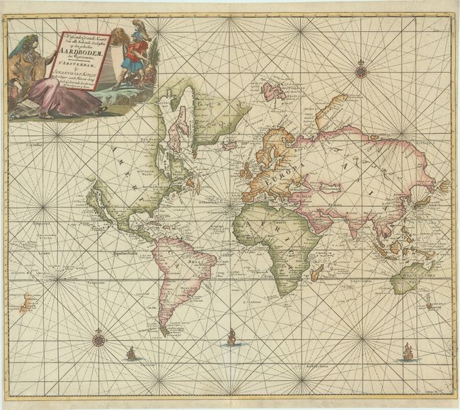
Auction 177, Lot 4
Subject: World
Keulen, Johannes van
Wassende Graade Kaart van alle Bekende Zeekusten op den Geheelen Aardbodem, 1697
Size: 23.7 x 20.2 inches (60.2 x 51.3 cm)
Estimate: $4,750 - $6,000
Scarce Chart of the World with Island of California and Recent Dutch Discoveries
Sold for: $3,750
Closed on 4/29/2020
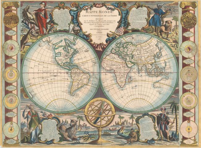
Auction 177, Lot 8
Subject: World
Nolin, Jean Batiste
Mappe Monde Carte Universelle de la Terre Dressee sur les Relations les Plus Nouvelles, Soumises aux Observations Astronomiques..., 1755
Size: 25.5 x 18.8 inches (64.8 x 47.8 cm)
Estimate: $3,000 - $4,000
Superbly Decorated Map with Large Sea of the West
Sold for: $3,250
Closed on 4/29/2020
Auction 177, Lot 10
Subject: World
Moithey, Maurille Antoine
Esquisse d'un Tableau General du Genre Humain. Ou l'on Appercoit d'un Seul Coup d'Oeil les Religions et les Moeurs des Differents Peuples..., 1787
Size: 26.3 x 19.4 inches (66.8 x 49.3 cm)
Estimate: $2,000 - $2,500
Rare Anthropological Map of the World by Female Cartographer
Sold for: $1,400
Closed on 4/29/2020
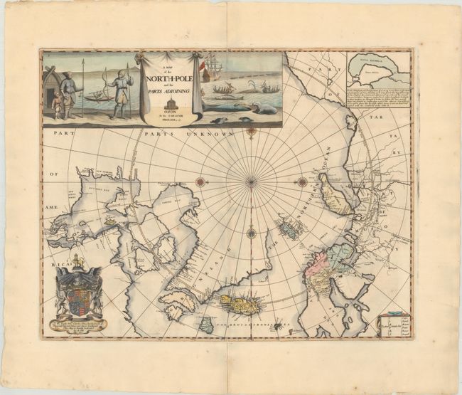
Auction 177, Lot 22
Subject: North Pole
Pitt, Moses
A Map of the North-Pole and the Parts Adioining, 1680
Size: 23.1 x 18 inches (58.7 x 45.7 cm)
Estimate: $3,500 - $4,250
Beautiful English Map of the North Pole
Sold for: $2,300
Closed on 4/29/2020
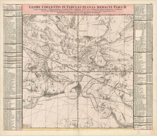
Auction 177, Lot 29
Subject: Celestial
Doppelmayr/Homann
[Lot of 5] Globi Coelestis in Tabulas Planas Redacti Pars II, III, IV, V, VI, 1730
Size: 22.9 x 19.2 inches (58.2 x 48.8 cm)
Estimate: $3,000 - $3,750
Lot of 5 of Doppelmayr's Magnificent Celestial Charts on a Gnomonic Projection
Sold for: $2,200
Closed on 4/29/2020
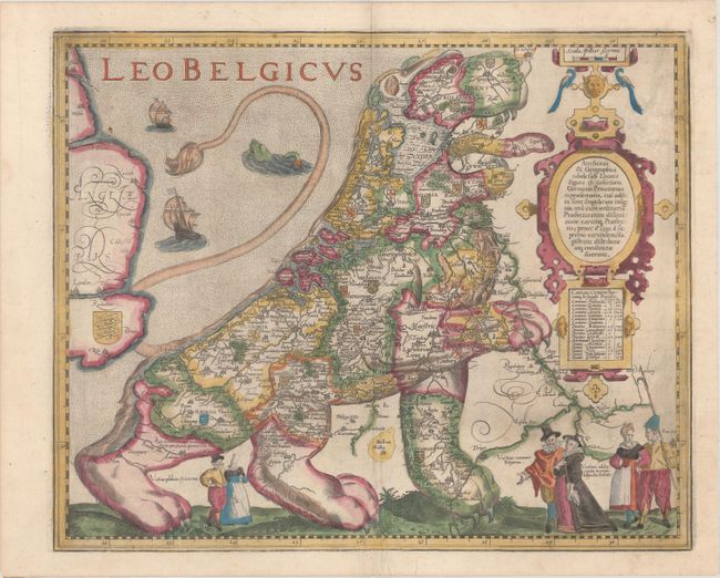
Auction 177, Lot 36
Subject: Cartographic Miscellany, Low Countries
Keere, Pieter Van Den
Leo Belgicus, 1617
Size: 17.9 x 14.6 inches (45.5 x 37.1 cm)
Estimate: $15,000 - $18,000
The Most Popular of the "Lions of Belgium" in Full Contemporary Color
Sold for: $11,000
Closed on 4/29/2020
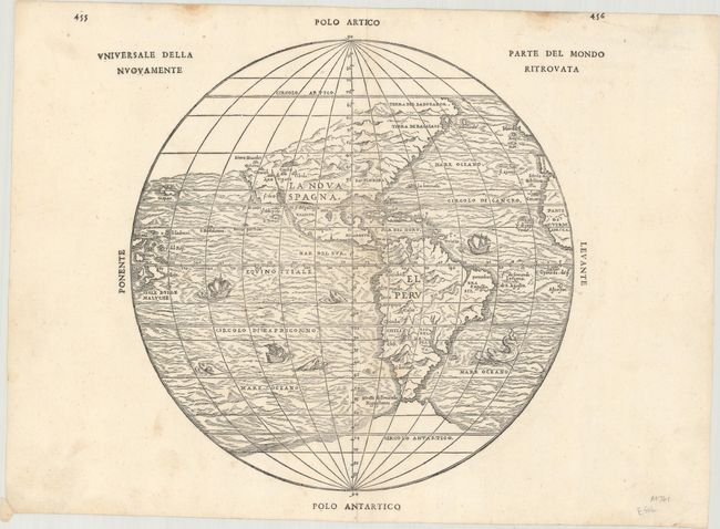
Auction 177, Lot 41
Subject: Western Hemisphere - America
Gastaldi/Ramusio
Universale della Parte del Mondo Nuovamente Ritrovata, 1565
Size: 11.9 x 11.5 inches (30.2 x 29.2 cm)
Estimate: $3,500 - $4,250
The First Printed Map to Reflect Coronado's Explorations in the Southwest
Sold for: $2,500
Closed on 4/29/2020
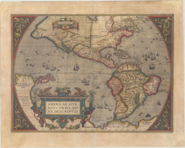
Auction 177, Lot 43
Subject: Western Hemisphere - America
Ortelius, Abraham
Americae sive Novi Orbis, Nova Descriptio, 1601
Size: 19 x 13.9 inches (48.3 x 35.3 cm)
Estimate: $4,000 - $4,750
Ortelius' Influential Map of the New World
Sold for: $3,000
Closed on 4/29/2020
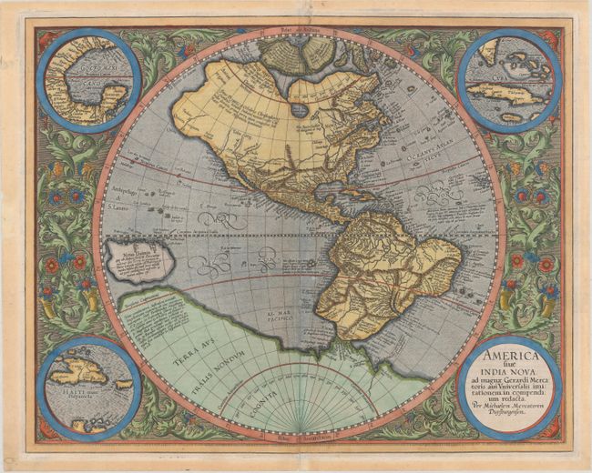
Auction 177, Lot 44
Subject: Western Hemisphere - America
Mercator/Hondius
America sive India Nova, ad Magnae Gerardi Mercatoris aui Universalis Imitationem, in Compendium Redacta, 1606
Size: 18.1 x 14.4 inches (46 x 36.6 cm)
Estimate: $3,000 - $3,750
Mercator's Foundation Map for the Americas
Sold for: $2,200
Closed on 4/29/2020
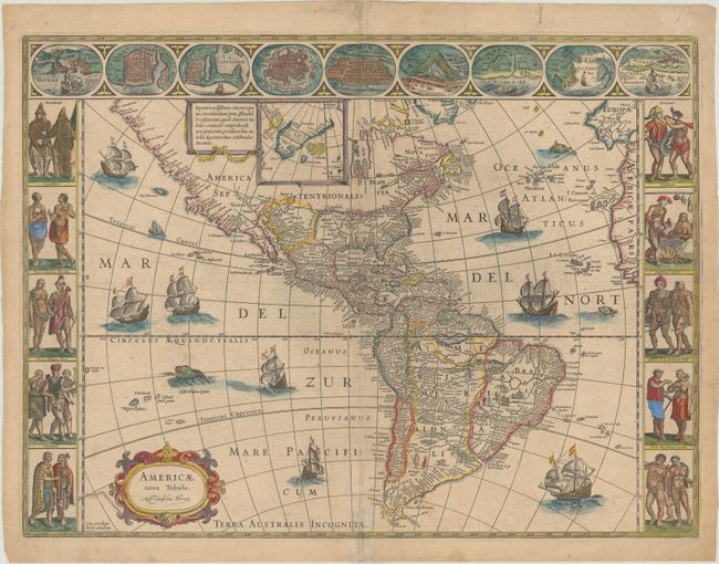
Auction 177, Lot 47
Subject: Western Hemisphere - America
Blaeu, Willem
Americae Nova Tabula, 1660
Size: 21.4 x 16 inches (54.4 x 40.6 cm)
Estimate: $5,000 - $6,000
Rare Example of Blaeu's Stunning Carte-a-Figures Map of the Americas with Blank Verso
Unsold
Closed on 4/29/2020
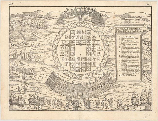
Auction 177, Lot 83
Subject: Montreal, Canada
Gastaldi/Ramusio
La Terra de Hochelaga Nella Nova Francia, 1556
Size: 14.4 x 10.6 inches (36.6 x 26.9 cm)
Estimate: $2,200 - $2,500
The First Published Plan of a Settlement in North America
Sold for: $1,900
Closed on 4/29/2020
Auction 177, Lot 88
Subject: Colonial Eastern United States & Canada
Hennepin, Louis de (Fr.)
Charte Eines sehr Grossen Landes nur Gantz Neulich in dem Mitternachtigen America..., 1698
Size: 16.7 x 14.4 inches (42.4 x 36.6 cm)
Estimate: $2,200 - $2,500
Rare Separately-Issued German Edition of Hennepin's Map of Eastern North America
Sold for: $2,200
Closed on 4/29/2020
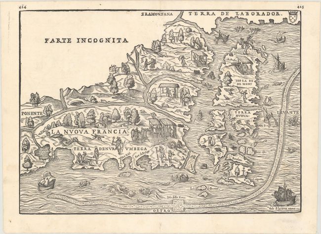
Auction 177, Lot 93
Subject: Northeastern United States & Canada
Gastaldi/Ramusio
La Nuova Francia, 1565
Size: 14.6 x 10.5 inches (37.1 x 26.7 cm)
Estimate: $3,000 - $3,750
The First Printed Map to Focus on New England and New France
Sold for: $3,250
Closed on 4/29/2020

Auction 177, Lot 94
Subject: Colonial Northeastern United States & Canada, Great Lakes
Champlain/Du Val
Le Canada Faict par le Sr de Champlain ou sont la Nouvelle France, la Nouvelle Angleterre, la Nouvelle Holande, la Nouvelle Suede, la Virginie &c..., 1670
Size: 21.4 x 13.8 inches (54.4 x 35.1 cm)
Estimate: $14,000 - $16,000
Very Rare Champlain/Duval Map of New France
Sold for: $10,500
Closed on 4/29/2020
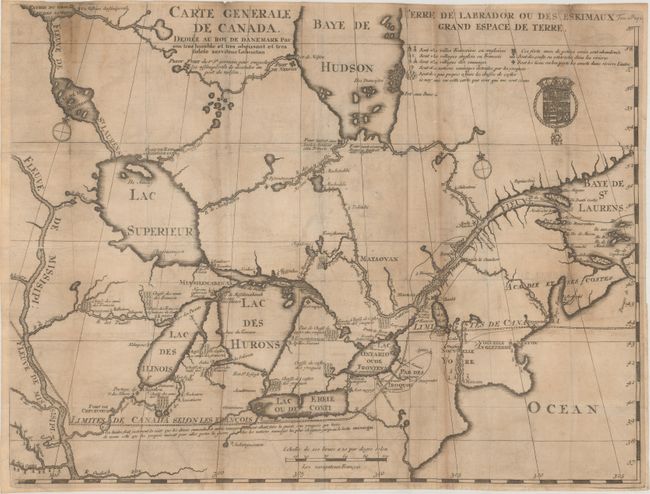
Auction 177, Lot 96
Subject: Colonial Northeastern United States & Canada, Great Lakes
Lahontan, Louis Armand, Baron de
Carte Generale de Canada. Dediee au Roy de Danemark par Son Tres Humble et Tres Obeissant et Tres Fidele Serviteur Lahontan, 1705
Size: 21.5 x 16.4 inches (54.6 x 41.7 cm)
Estimate: $2,200 - $2,500
Lahontan's Map of Canada and the Great Lakes
Sold for: $1,600
Closed on 4/29/2020
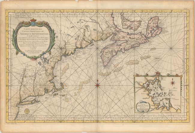
Auction 177, Lot 97
Subject: Colonial Northeastern United States & Canada
Bellin, Jacques Nicolas
Carte Reduite des Costes Orientales de l'Amerique Septentrionale 1re Feuille Contenant l'Isle Royale, l'Accadie, la Baye Francoise, la Nouvelle Angleterre et la Nouvelle Yorc..., 1757
Size: 34.9 x 21.5 inches (88.6 x 54.6 cm)
Estimate: $1,600 - $1,900
Scarce Large-Scale Chart of the Coast of New England
Sold for: $980
Closed on 4/29/2020
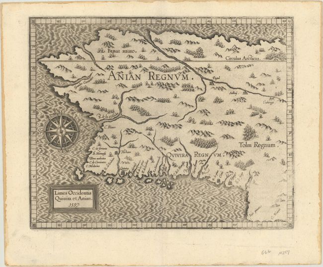
Auction 177, Lot 103
Subject: Alaska & Western Canada
Wytfliet, Cornelis
Limes Occidentis Quivira et Anian, 1597
Size: 11.4 x 9.1 inches (29 x 23.1 cm)
Estimate: $2,000 - $2,300
Early and Imaginary Map of Alaska and the Northwest Passage
Sold for: $1,400
Closed on 4/29/2020
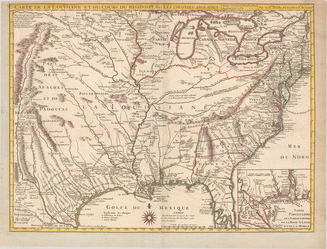
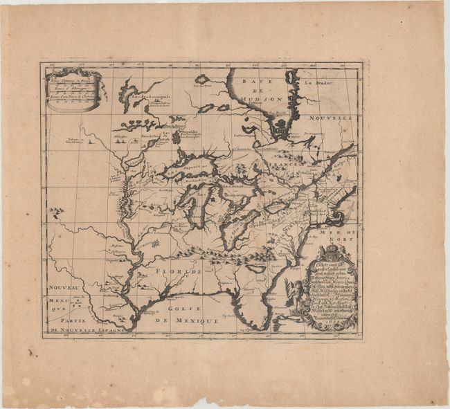
Auction 177, Lot 112
Subject: Colonial Eastern United States, Louisiana Territory
Delisle/Dezauche
Carte de la Louisiane et du Cours du Mississipi avec les Colonies Anglaises, 1782
Size: 25.6 x 19.2 inches (65 x 48.8 cm)
Estimate: $1,400 - $1,700
Delisle's Influential Map of the Louisiana Territory
Sold for: $1,000
Closed on 4/29/2020
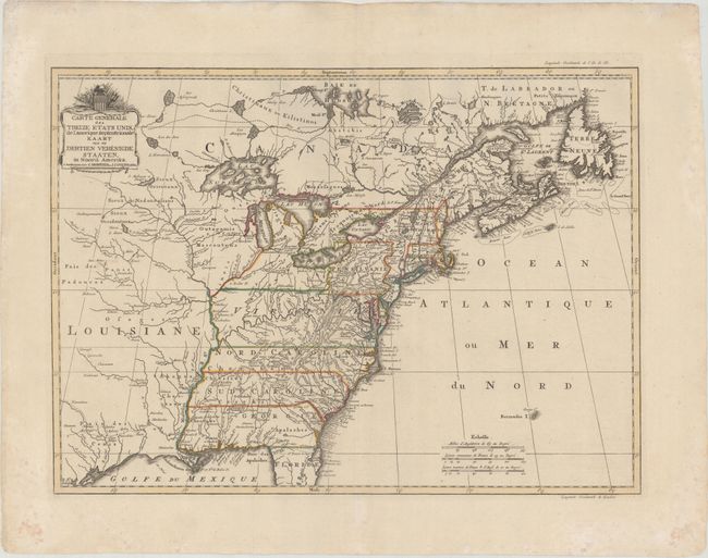
Auction 177, Lot 113
Subject: Eastern United States
Covens & Mortier
Carte Generale des Treize Etats Unis, de l'Amerique Septentrionale / Kaart van de Dertien Verenigde Staaten, in Noord Amerika, 1783
Size: 22.2 x 16.1 inches (56.4 x 40.9 cm)
Estimate: $2,200 - $2,500
Covens and Mortier's Map of the Young United States, with an Early Appearance of the Stars and Stripes
Sold for: $1,600
Closed on 4/29/2020
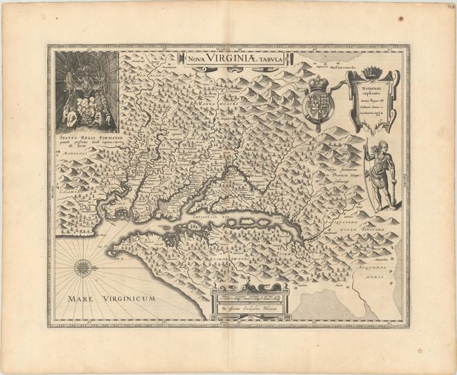
Auction 177, Lot 128
Subject: Colonial Mid-Atlantic United States
Hondius/Blaeu
Nova Virginiae Tabula, 1634
Size: 18.9 x 14.8 inches (48 x 37.6 cm)
Estimate: $1,900 - $2,200
One of the Most Important 17th Century Maps of the Chesapeake Bay
Sold for: $1,400
Closed on 4/29/2020
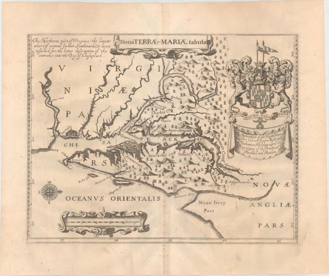
Auction 177, Lot 129
Subject: Colonial Mid-Atlantic United States, Maryland
Ogilby, John
Nova Terrae-Mariae Tabula, 1671
Size: 14.8 x 11.6 inches (37.6 x 29.5 cm)
Estimate: $5,500 - $7,000
Ogilby's Copy of the Extremely Rare "Lord Baltimore's Map," the Earliest Obtainable Printed Map of Maryland
Sold for: $4,000
Closed on 4/29/2020
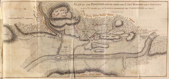
Auction 177, Lot 226
Subject: Colonial New York, Vermont, Revolutionary War
A State of the Expedition from Canada, as Laid Before the House of Commons, 1780
Size: 5.4 x 8.5 inches (13.7 x 21.6 cm)
Estimate: $2,750 - $3,500
General Burgoyne's Account with 6 Battle Maps
Sold for: $2,000
Closed on 4/29/2020
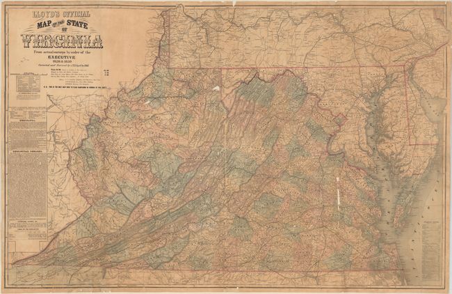
Auction 177, Lot 249
Subject: Virginia & West Virginia, Civil War
Lloyd, James T.
Lloyd's Official Map of the State of Virginia from Original Surveys by Order of the Executive 1828 & 1859..., 1861
Size: 47.3 x 30.3 inches (120.1 x 77 cm)
Estimate: $2,750 - $3,500
First Edition of Lloyd's Civil War Map of Virginia
Unsold
Closed on 4/29/2020
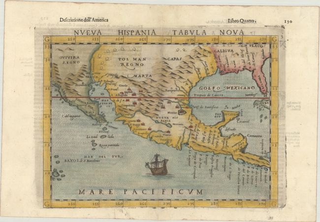
Auction 177, Lot 262
Subject: Southern United States & Mexico
Ruscelli, Girolamo
Nueva Hispania Tabula Nova, 1598
Size: 9.7 x 7.1 inches (24.6 x 18 cm)
Estimate: $1,200 - $1,500
A Foundation Map for the American Southwest
Sold for: $600
Closed on 4/29/2020
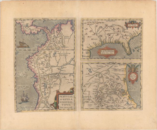
Auction 177, Lot 284
Subject: Gulf of Mexico, Florida & Peru
Ortelius, Abraham
Peruviae Auriferae Regionis Typus. Didaco Mendezio Auctore [on sheet with] La Florida. Auctore Hieron. Chiaves [and] Guastecan Reg., 1592
Size: 18.1 x 13.1 inches (46 x 33.3 cm)
Estimate: $1,000 - $1,300
The First Printed Map of the Southern United States
Sold for: $750
Closed on 4/29/2020
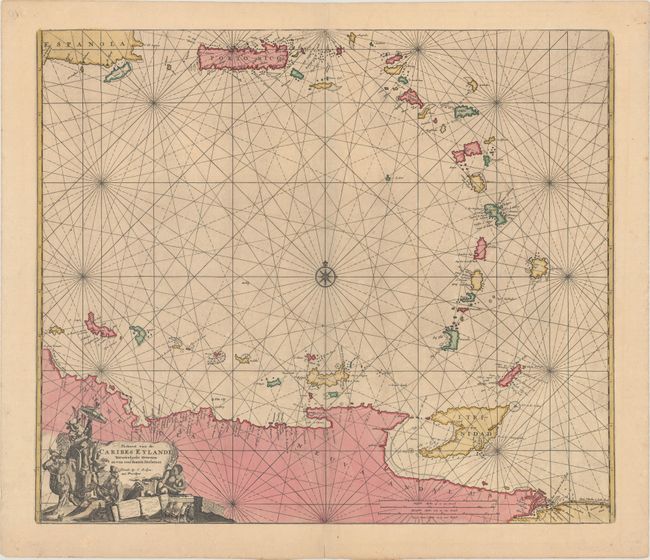
Auction 177, Lot 306
Subject: Lesser Antilles & Northern South America
Robijn (Robyn), Jacobus
Paskaert van de Caribes: Eylande. Nieuwelycks Oversien en van Veel Fouteinl Verbetert, 1683
Size: 22.3 x 19 inches (56.6 x 48.3 cm)
Estimate: $3,000 - $3,750
Rare Sea Chart of the Lesser Antilles
Sold for: $3,000
Closed on 4/29/2020
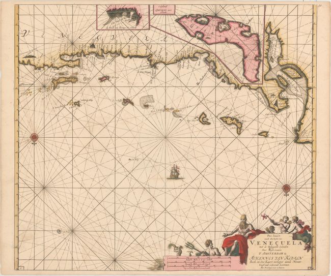
Auction 177, Lot 323
Subject: Venezuela
Keulen/Vooght
Pas-kaart vande Zee Kusten van Venecuela met de Byleggende Eylanden..., 1680
Size: 23.1 x 20.3 inches (58.7 x 51.6 cm)
Estimate: $700 - $850
Superb Early Chart of the Venezuelan Coastline Including the ABC Islands
Sold for: $500
Closed on 4/29/2020
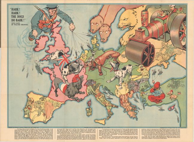
Auction 177, Lot 359
Subject: Europe, World War I
Bacon, G. W. & Company
Hark! Hark! The Dogs Do Bark!, 1914
Size: 27.6 x 19 inches (70.1 x 48.3 cm)
Estimate: $1,400 - $1,700
Rare Political Caricature Pocket Map Depicting European Countries as Dogs
Sold for: $1,000
Closed on 4/29/2020

Auction 177, Lot 360
Subject: Europe, World War I
Het Gekkenhuis (Oud Liedje, Nieuwe Wijs), 1914
Size: 20.4 x 15.8 inches (51.8 x 40.1 cm)
Estimate: $1,200 - $1,500
Rare Dutch Satirical Map of World War I
Unsold
Closed on 4/29/2020
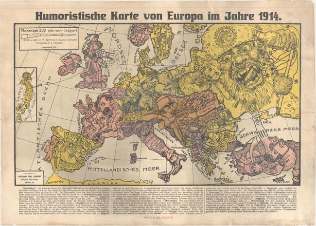
Auction 177, Lot 361
Subject: Europe, World War I
Humoristische Karte von Europa im Jahre 1914, 1914
Size: 18.9 x 10.8 inches (48 x 27.4 cm)
Estimate: $1,000 - $1,300
Rare Pro-German Propaganda Targeting German Immigrants within the United States
Sold for: $700
Closed on 4/29/2020
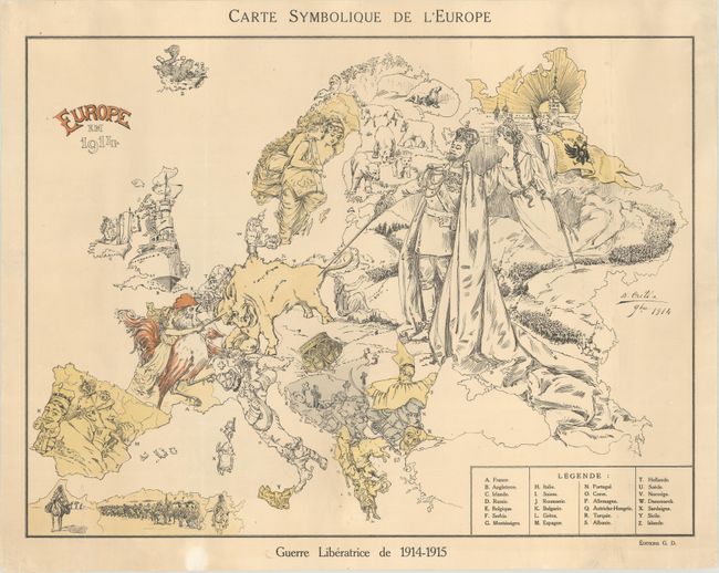
Auction 177, Lot 362
Subject: Europe, World War I
Carte Symbolique de l'Europe / Europe en 1914, 1915
Size: 21.9 x 16.4 inches (55.6 x 41.7 cm)
Estimate: $1,200 - $1,500
Rare Satirical Map of Europe at Start of World War I
Sold for: $800
Closed on 4/29/2020
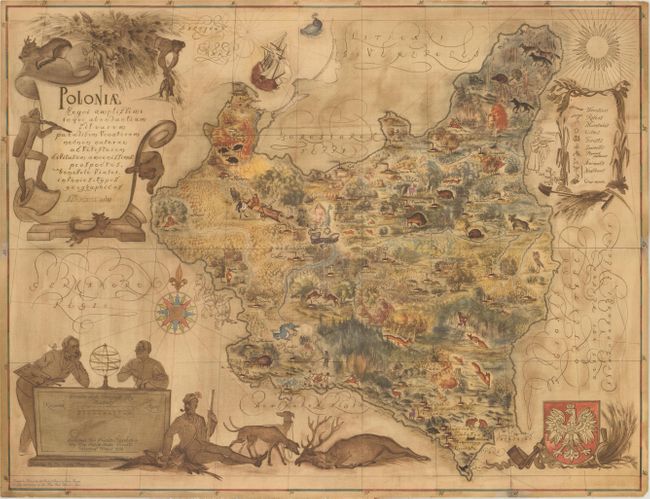
Auction 177, Lot 475
Subject: Poland
Poloniae Regni Amplissimi in quo Abondantiam Silvarum Paradisum Venatorum..., 1938
Size: 17.4 x 13.3 inches (44.2 x 33.8 cm)
Estimate: $350 - $425
Rare Map Promoting Polish Lumber Industry with Hidden Anti-German and Anti-USSR Message
Sold for: $400
Closed on 4/29/2020
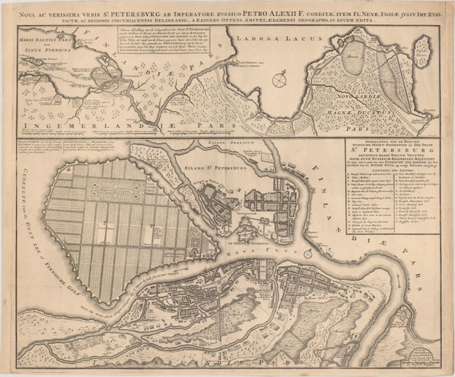
Auction 177, Lot 508
Subject: St. Petersburg, Russia
Ottens, Reiner and Joshua
Nova ac Verissima Urbis St. Petersburg ab Imperatore Russico Petro Alexii F. Conditae, Item Fl. Nevae, Fossae Jussu Imp. Russ..., 1720
Size: 23.3 x 18.8 inches (59.2 x 47.8 cm)
Estimate: $1,400 - $1,700
Great Map Illustrating Peter the Great's Plans for St. Petersburg
Sold for: $750
Closed on 4/29/2020
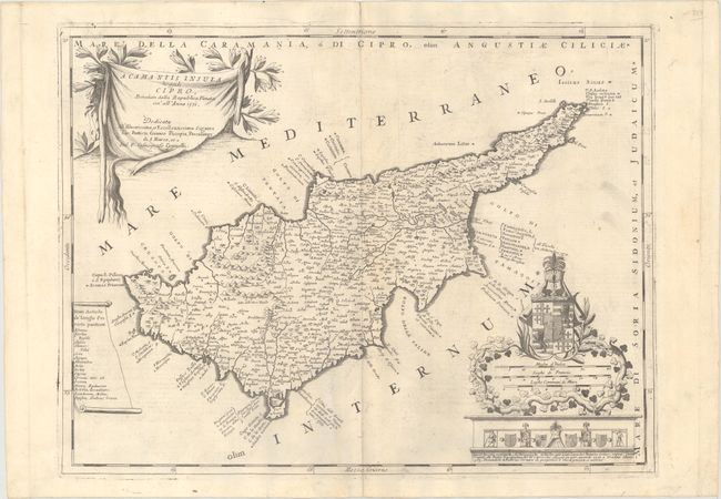
Auction 177, Lot 563
Subject: Cyprus
Coronelli, Vincenzo Maria
Acamantis Insula, Hoggidi Cipro..., 1690
Size: 24.1 x 18.1 inches (61.2 x 46 cm)
Estimate: $2,500 - $3,250
Coronelli's Decorative Map of Cyprus
Sold for: $1,300
Closed on 4/29/2020
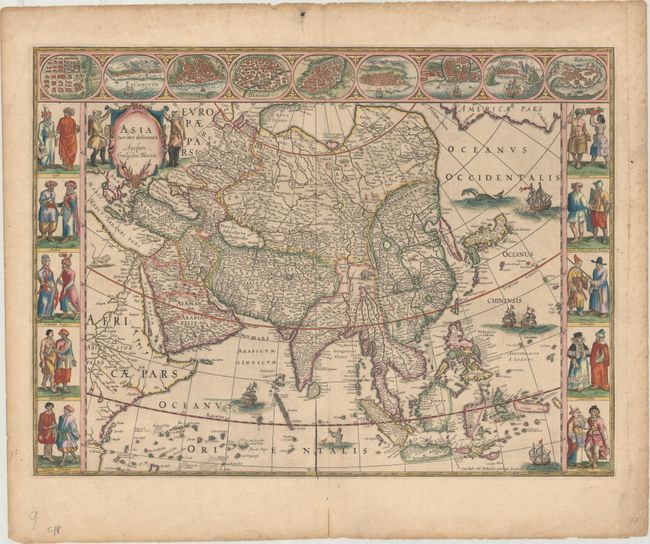
Auction 177, Lot 620
Subject: Asia
Blaeu, Willem
Asia Noviter Delineata, 1642
Size: 21.9 x 16.1 inches (55.6 x 40.9 cm)
Estimate: $3,750 - $4,500
Magnificent Carte-a-Figures Map of Asia
Sold for: $2,750
Closed on 4/29/2020
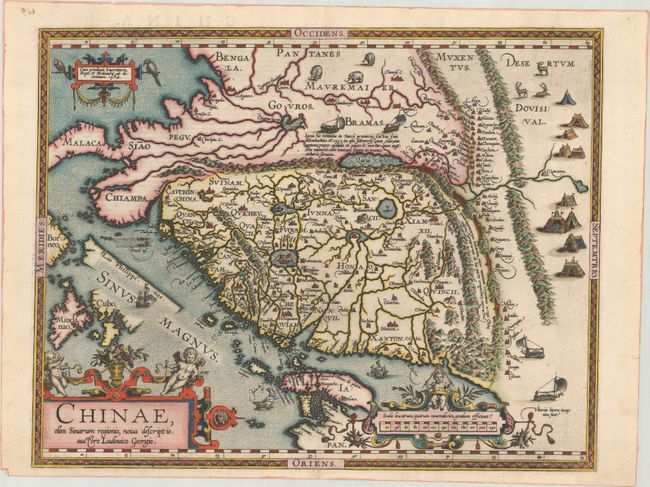
Auction 177, Lot 629
Subject: China
Ortelius, Abraham
Chinae, olim Sinarum Regionis, Nova Descriptio. Auctore Ludovico Georgio, 1584
Size: 18.4 x 14.4 inches (46.7 x 36.6 cm)
Estimate: $5,500 - $6,500
The First European-Printed Map of China
Sold for: $4,000
Closed on 4/29/2020
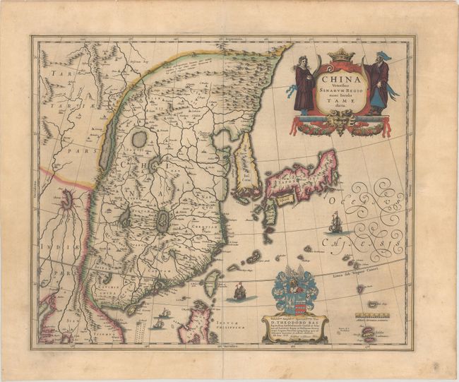
Auction 177, Lot 634
Subject: China, Korea & Japan
Blaeu, (Family)
China Veteribus Sinarum Regio nunc Incolis Tame Dicta, 1635
Size: 19.5 x 16.1 inches (49.5 x 40.9 cm)
Estimate: $1,600 - $1,900
Blaeu's Map of China Featuring Fictitious Lakes and Rivers in Full Contemporary Color
Sold for: $900
Closed on 4/29/2020
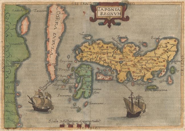
Auction 177, Lot 635
Subject: Japan & Korea
Botero, Giovanni
Iaponia Regnum, 1596
Size: 8.3 x 5.8 inches (21.1 x 14.7 cm)
Estimate: $3,000 - $3,750
Rare First Derivative of Ortelius/Teixeira Map of Japan
Sold for: $2,200
Closed on 4/29/2020
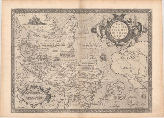
Auction 177, Lot 717
Subject: North Pacific Ocean
Ortelius, Abraham
Tartariae sive Magni Chami Regni Typus, 1571
Size: 18.6 x 13.8 inches (47.2 x 35.1 cm)
Estimate: $1,100 - $1,400
An Exquisite Example in Black & White
Sold for: $800
Closed on 4/29/2020
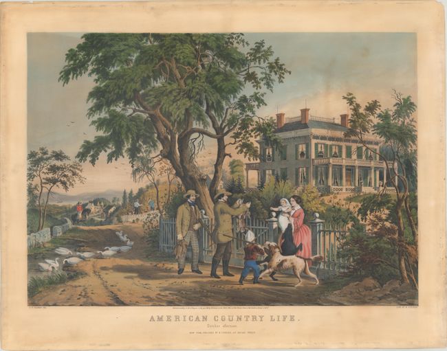
Auction 177, Lot 737
Subject: Prints - American Life
Currier & Ives
American Country Life. October Afternoon, 1855
Size: 23.8 x 16.7 inches (60.5 x 42.4 cm)
Estimate: $2,500 - $3,250
Splendid View of Country Life in Autumn
Sold for: $1,800
Closed on 4/29/2020
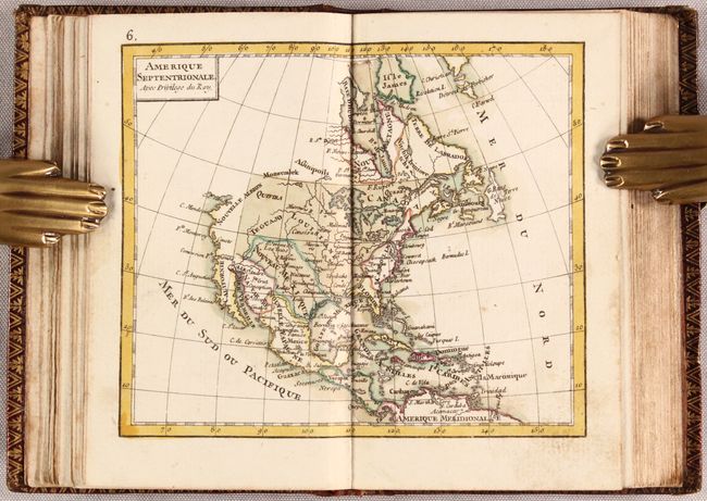
Auction 177, Lot 777
Subject: Atlases
Porcacchi, Tomaso
L'Isole Piu Famose del Mondo Descritte da Thomaso Porcacchi da Castiglione..., 1590
Size: 8.1 x 11.5 inches (20.6 x 29.2 cm)
Estimate: $4,750 - $6,000
Porcacchi's Island Atlas with 47 Maps
Sold for: $3,750
Closed on 4/29/2020
Auction 177, Lot 778
Subject: Atlases
Hondius/Bertius
P Bertij Tabularum Geographicarum Contractarum Libri Septem. In Quibus Tabulae Omnes Gradibus Distinctae, Descriptiones Accuratae..., 1618
Size: 7.5 x 5 inches (19.1 x 12.7 cm)
Estimate: $11,000 - $14,000
Miniature Atlas with Over 200 Maps by Hondius
Unsold
Closed on 4/29/2020
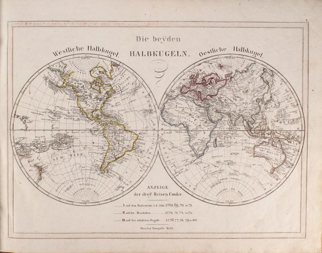
Auction 177, Lot 780
Subject: Atlases
Rizzi-Zannoni, Giovanni Antonio
Atlas Geographique Contenant la Mappemonde et les Quatre Parties, avec les Differents Etats d'Europe..., 1775
Size: 3.4 x 5.1 inches (8.6 x 13 cm)
Estimate: $1,400 - $1,700
Remarkable Miniature Atlas with 30 Maps
Sold for: $1,000
Closed on 4/29/2020
Auction 177, Lot 783
Subject: Atlases
Dirwaldt, Joseph
Allgemeiner Hand-Atlas zum Gebrauch fur die Jugend in Hoehern und Niedern Schulen..., 1818
Size: 20.5 x 15.7 inches (52.1 x 39.9 cm)
Estimate: $1,000 - $1,400
Rare Austrian School Atlas in Original Color
Sold for: $350
Closed on 4/29/2020
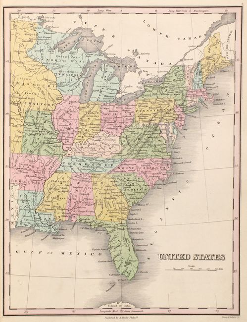
Auction 177, Lot 784
Subject: Atlases
Finley, Anthony
A New General Atlas, Comprising a Complete Set of Maps, Representing the Grand Divisions of the Globe..., 1824
Size: 10.9 x 14.1 inches (27.7 x 35.8 cm)
Estimate: $3,750 - $4,750
First Edition of Finley's General Atlas
Unsold
Closed on 4/29/2020
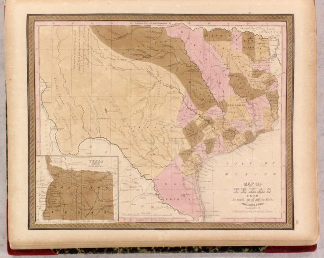
Auction 177, Lot 787
Subject: Atlases
Mitchell, Samuel Augustus
A New Universal Atlas Containing Maps of the Various Empires, Kingdoms, States and Republics of the World..., 1849
Size: 14.3 x 17.8 inches (36.3 x 45.2 cm)
Estimate: $2,750 - $3,500
Mitchell's Desirable Atlas with 73 Plates
Sold for: $2,500
Closed on 4/29/2020
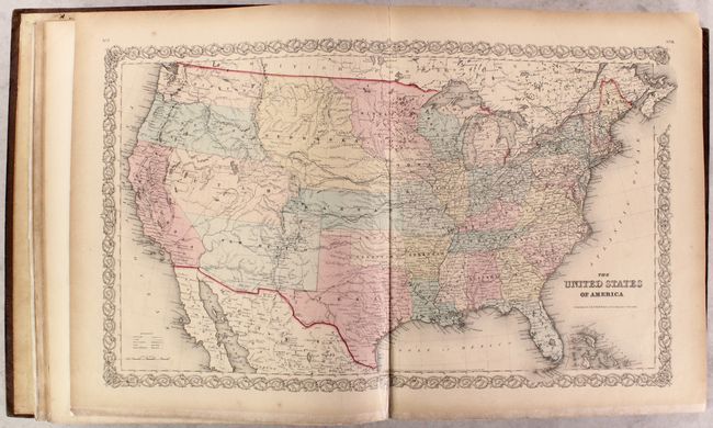
Auction 177, Lot 788
Subject: Atlases
Colton, Joseph Hutchins
[2 Volumes] Colton's Atlas of the World, Illustrating Physical and Political Geography..., 1856
Size: 16.6 x 19 inches (42.2 x 48.3 cm)
Estimate: $2,500 - $3,250
Colton's Superb Two-Volume Atlas of the World
Sold for: $1,800
Closed on 4/29/2020
Auction 177, Lot 793
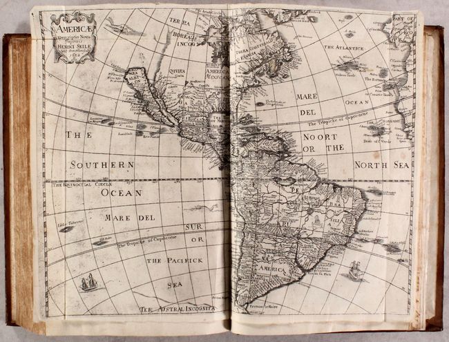
Subject: Geography Books
Heylin, Peter
Cosmographie in Foure Bookes Contayning the Chorographie & Historie of the Whole World, and All the Principall Kingdomes, Provinces, Seas, and Isles, Thereof, 1652
Size: 9.4 x 13.8 inches (23.9 x 35.1 cm)
Estimate: $1,700 - $2,000
Includes Four Maps of the Continents by Henry Seile
Sold for: $1,300
Closed on 4/29/2020
48 lots