Subject: Virginia & West Virginia, Civil War
Period: 1861 (dated)
Publication:
Color: Hand Color
Size:
47.3 x 30.3 inches
120.1 x 77 cm
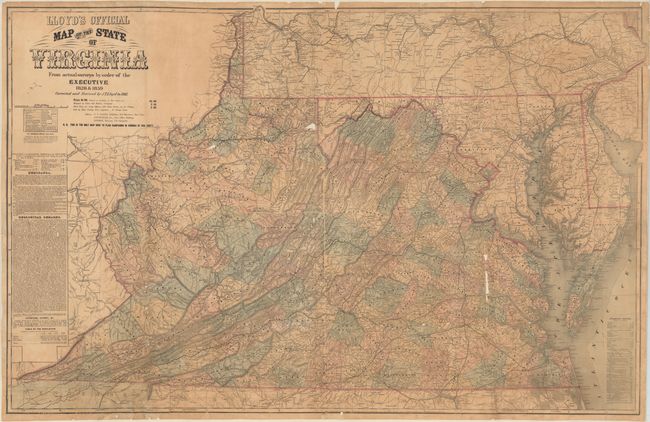
This scarce, large-scale folding map depicts Virginia during the Civil War, and was based on the Boye-Bucholtz four-sheet map of 1859. Originally published as a nine-sheet map in 1827, the Boye-Bucholtz map of Virginia was a landmark in its time, being "the largest and finest map of the state produced in the nineteenth century," according to Wooldridge. The surveying, drafting and engraving took a decade of work and $80,000 to complete and resulted in a map that was nearly forty square feet in size. A reduced-size version was also authorized, which appeared in 1859 and served as the basis for Lloyd's map of the state. Of course when Lloyd first published his edition in 1861, he marketed it as "Lloyd's $100,000 Topographical Map of Virginia Used by the War Department" (on the covers, not present here). And although the title of the map was "Lloyd's Official Map of the State of Virginia," the map had not been granted any official status by the state government.
This first edition map was "corrected and revised by J.T. Lloyd to 1861" and was "the only map used to plan campaigns in Virginia by General Scott." The second edition of this map updated generals from the aging Scott to McClellan. As part of Llyod's marketing strategy, the map would go through several editions with varying text and advertisements surrounding the map in order to keep it fresh and relevant to the public.
The map itself is filled with detail, including counties, towns, roads, rivers, and topographical detail. The map extends to include all of Maryland and southern Pennsylvania. Railroad lines are depicted throughout most of Virginia, including the Richmond and Lynchburg; the Richmond and Danville; the Orange and Alexandria; and the Virginia and Tennessee. Many of these rail lines were indispensable during the Civil War. Also identified are mills, factories, iron works, forts, batteries, colleges and houses of worship. To the left of the map are geological remarks describing the rock and soil formations that are found in different areas of the state. Below the geological remarks is a table listing the white, slave and free black populations of the state in 1790, 1800, 1810, and 1859, showing the dramatic growth of the state.
Covers not present. No auction records of this first edition map in the last 20 years.
References: Wooldridge, pp. 257-61; Stephenson #465; Modelski #310.
Condition: B
Originally issued folding and now flattened and professionally conserved with heavy archival tissue to reinforce and repair numerous fold separations, small tears, and edge chips. There are several small areas of loss along the fold lines, as well as light toning and minor soiling.