Subject: Poland
Period: 1938 (dated)
Publication:
Color: Hand Color
Size:
17.4 x 13.3 inches
44.2 x 33.8 cm
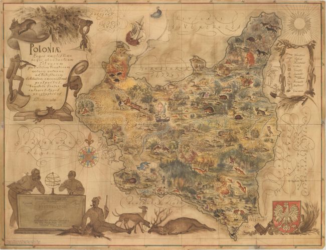
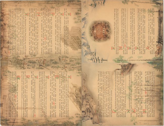
This charming pictorial map was published by the Polish Central Board of State Forests to promote Poland's lumber industry at the 1939 New York World's Fair. At first glance the map appears to focus on the diverse wildlife and hunting opportunities in Poland, with images of hunters, foxes, deer, bears, and wolves shown throughout (as well as a lone dragon near Krakow). However the verso of the map is dedicated to impressing the reader with dozens of facts about Poland's international timber trade, run by the Department of Polish State Forests. The verso depicts various facets of the lumber industry, with images of loggers felling trees, a large trunk being transported by a horse-drawn sled, and a lumber mill, and lumber being transported by ship. The map itself, which extends into parts of present-day Lithuania, Belarus and Ukraine, also identifies the locations of each sawmill and plywood factory in Poland.
Although this map was published just before the start of World War II, the looming war is foreshadowed in the map with the depiction of an NKVD firing squad along the eastern border (adjacent to the legend) and a troop of Germanic Vikings holding shields and offering Nazi salutes along the western border (adjacent to the compass rose). These illustrations are only drawn in outline, in contrast to the rest of the map with images boldly shadowed or colored, likely in an attempt to hide the political nature of the map. However the anti-Third Reich and anti-USSR sentiments did not go unnoticed, and the map was withdrawn from circulation and preserved copies were destroyed. As a result, this map is exceedingly rare.
The map was drawn by Eliasz Kanarek and Tadeusz Lipski and was first published in a larger edition (approximately 29.3 x 22.6") for private circulation in Warsaw around Christmas 1938. This smaller edition was distributed for free at the 1939 New York World's Fair.
References:
Condition: A
Issued folding with a couple of tiny chips and creases along the edges of the sheet, and two short edge tears that have been archivally repaired.