Subject: Colonial New York, Vermont, Revolutionary War
Period: 1780 (published)
Publication:
Color: Black & White
Size:
5.4 x 8.5 inches
13.7 x 21.6 cm
This is British General John Burgoyne's defense of conduct related to the Campaign of 1777, in which he led British troops from Canada through New York and Vermont in an attempt to divide the northern and southern colonies and thereby end the American rebellion. Burgoyne and his 7,000 troops had some early success at Ticonderoga, Huberton, and the Battle of Freeman's Farm, but his gains were erased a few weeks later at Bemis Heights. When Burgoyne retreated to Saratoga, he found himself surrounded by 20,000 American troops and was forced to surrender. Concerning this volume, the Monthly Review (quoted in Sabin) wrote: "General Burgoyne writes well. His very interesting story is told in a masterly manner, and the materials of which it is composed will be held in great estimation by historians, who shall record the events of the unhappy war, to which they owe their birth." Burgoyne's work is illustrated by the following six maps by William Faden. These maps are particularly well presented because he based them on manuscript maps supplied to him from the war zone:
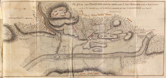
Plan of the Position Which the Army Under Lt. Genl. Burgoine Took at Saratoga on the 10th of September 1777, and In Which It Remained Till the Convention Was Signed (18.7 x 8.6"). This map, with north oriented to the right, shows British troops just north of Fish Kill. Gates' army is depicted on the south bank of Fish Kill while Dan Morgan’s riflemen are shown to the north and west of the British positions. Condition: Light offsetting. (B+)
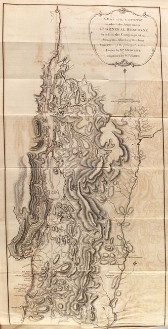
A Map of the Country in Which the Army under Lt. General Burgoyne Acted in the Campaign of 1777... (10.8 x 22.3"). This detailed and important map covers the area from the Chambly River (Richelieu River) south through Lake Champlain to Albany on the Hudson River. With the use of red hand coloring, the route of Burgoyne's ill fated campaign to split the northeast colonies from the southern colonies is depicted. Condition: Moderate offsetting with two small repaired edge tears at bottom. (B)
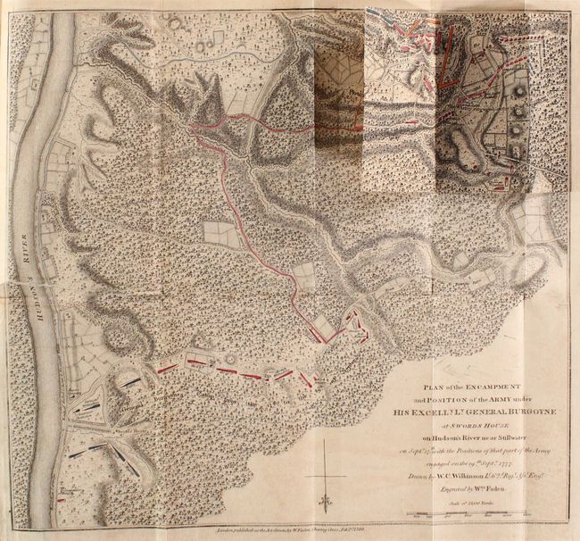
Plan of the Encampment and Position of the Army Under His Excelly. Lt. General Burgoyne at Swords House on Hudson's River Near Stillwater... (13.5 x 12.4"). This detailed and uncommon battle plan shows the placement of British and American forces during the first part of the Battle of Saratoga (also called the Battle of Freeman's Farm) in September of 1777. The first and second battle of Saratoga were fought nineteen days apart and were a critical turning point in the war. An overlay at top right shows troop positions before and after the battle. These overlays were located at the end of the atlas and could be hinged to the map. Condition: Light offsetting with a 3.5" edge tear at left that has been repaired on verso with archival materials. (B+)
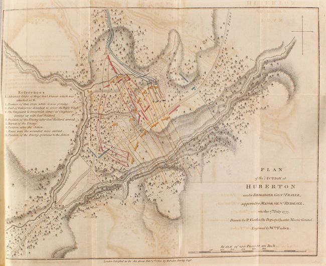
Plan of the Action at Huberton Under Brigadier Genl. Frazer, Supported by Major Genl. Reidesel, on the 7th July 1777 (13.8 x 10.8"). This detailed and uncommon battle plan depicts the only pitched battle fought in Vermont during the American Revolution. The positions of British Brigadier General Frazer's men, the German mercenaries under General Reidesel, and Seth Warner's Green Mountain men are clearly noted with red and blue hand coloring. An alphabetized index at left gives clarification to the battle lines displayed. The British eventually routed the Americans with a somewhat higher casualty count, but captured some 260 American prisoners. Condition: Moderate offsetting. (B)
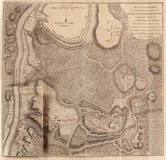
Plan of the Encampment and Position of the Army Under His Excelly. Lt. General Burgoyne at Braemus Heights on Hudson's River Near Stillwater... (13.9 x 13.5"). This detailed and uncommon battle plan shows the placement of British and American forces during the second Battle of Saratoga (also known as the Battle of Bemis Heights), which took place in October 1777. An interesting overlay at bottom left shows the change in positions of the two armies from the first to second battle, with the Americans advancing north (with north oriented to the bottom). The second battle of Saratoga proved to be the demise of Lt. General Burgoyne’s campaign as the British troops surrendered to General Horatio Gates on October 17th, 1777. This major turning point strongly contributed to the formation of the Franco-American alliance, which eventually assured the success of the Americans. Condition: Faint offsetting. (A)
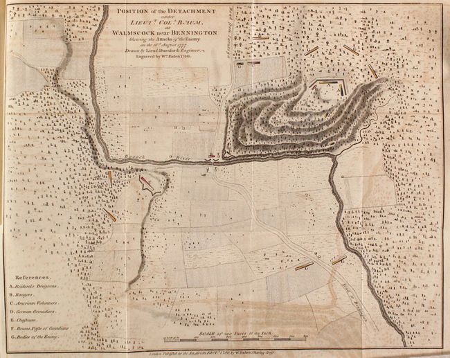
Position of the Detachment Under Lieutt. Coll. Baum, at Walmstock Near Bennington Shewing the Attacks of the Enemy on the 16th August 1777 (13.6 x 10.8"). This detailed battle plan shows the placement of British and American forces during the Battle of Benington in August of 1777. While one of the smaller battles of the war, it was a stunning example of Burgoyne’s poor planning. Burgoyne’s logistical issues stemmed from the fact that he had a long communication line with Canada. The raid was supposed to be a simple exercise to acquire supplies and enlist Tory support which would allow them to march on to Albany. However, the British didn’t realize that 1,500 American troops under Colonel Stark happened to be in the area and completely overwhelmed the much smaller British force including its commander, Lieutenant Colonel Frederick Baum. Condition: Light offsetting. (B+)
Second edition. Preface, introduction, advertisement, 191 pages of text, 109 page appendix, and six maps. Hardbound, rebacked with original leather boards.
References: Sabin #9255; Howes #B-968; Nebenzahl (Biblio) #48, 51-53, 56, 57.
Condition: B+
See description above for condition of maps. Text is lightly toned with occasional foxing. Rebacked with original boards, which are bumped and chipped along the edges.