Showing Featured Lots(remove filter)
Showing results for:Auction 148
Catalog Archive
75 lots
Page 1 of 2
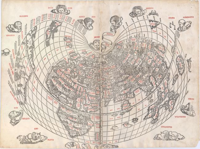
Auction 148, Lot 10
Subject: World
Sylvanus, Bernard
[Untitled - World], 1511
Size: 22 x 16.3 inches (55.9 x 41.4 cm)
Estimate: $60,000 - $75,000
Sylvanus' Rare and Significant Cordiform World Map
Sold for: $27,500
Closed on 2/19/2014
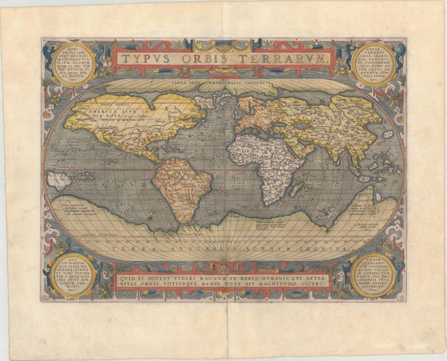
Auction 148, Lot 12
Subject: World
Ortelius, Abraham
Typus Orbis Terrarum, 1587
Size: 19.4 x 14.1 inches (49.3 x 35.8 cm)
Estimate: $7,500 - $9,000
Ortelius' Third World Map in an Oval Projection
Sold for: $5,500
Closed on 2/19/2014
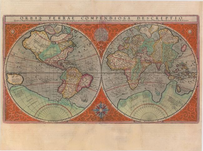
Auction 148, Lot 13
Subject: World
Mercator, Rumold
Orbis Terrae Compendiosa Descriptio…, 1587
Size: 20.7 x 11.4 inches (52.6 x 29 cm)
Estimate: $4,000 - $5,000
Mercator's Double-Hemisphere World Map
Unsold
Closed on 2/19/2014
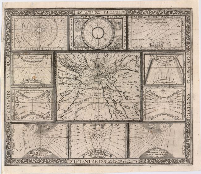
Auction 148, Lot 15
Subject: World
Ritter, Franz
[Untitled - World and Horological Diagrams], 1607
Size: 13.4 x 11.2 inches (34 x 28.4 cm)
Estimate: $3,000 - $3,750
Ritter's Unusual Sun-Dial World Map - First State
Sold for: $2,000
Closed on 2/19/2014
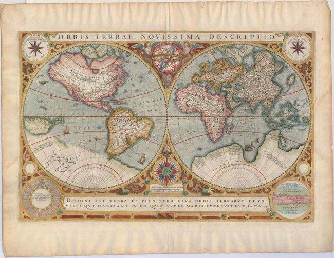
Auction 148, Lot 16
Subject: World
Hondius/Le Clerc
Orbis Terrae Novissima Descriptio, 1633
Size: 19.9 x 12.9 inches (50.5 x 32.8 cm)
Estimate: $5,500 - $6,500
Le Clerc's Decorative World Map Engraved by Hondius
Sold for: $3,500
Closed on 2/19/2014
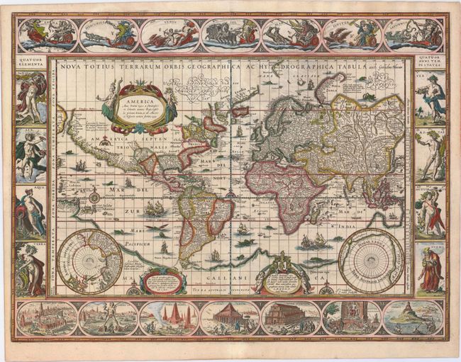
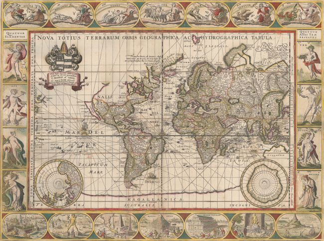
Auction 148, Lot 17
Subject: World
Blaeu, Willem
Nova Totius Terrarum Orbis Geographica ac Hydrographica Tabula, 1640
Size: 21.6 x 16.2 inches (54.9 x 41.1 cm)
Estimate: $14,000 - $16,000
Blaeu's Magnificent Carte-a-Figures World Map
Sold for: $12,500
Closed on 2/19/2014
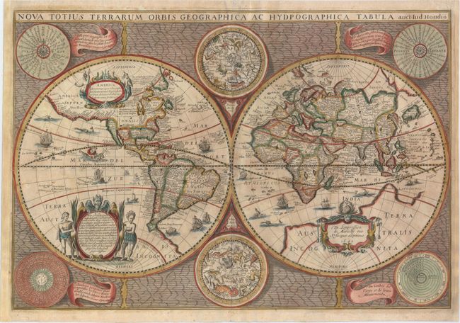
Auction 148, Lot 18
Subject: World
Hondius/Mariette
Nova Totius Terrarum Orbis Geographica ac Hydpographica Tabula, 1642
Size: 22 x 15 inches (55.9 x 38.1 cm)
Estimate: $5,000 - $6,000
Mariette's Rare and Decorative Map of the World Based on Hondius
Sold for: $3,000
Closed on 2/19/2014
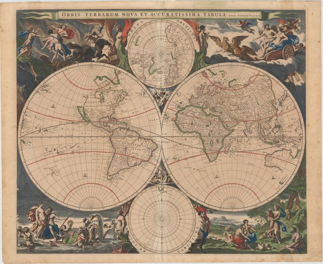
Auction 148, Lot 19
Subject: World
Visscher, Nicolas
Orbis Terrarum Nova et Accuratissima Tabula, 1658
Size: 22.1 x 18.4 inches (56.1 x 46.7 cm)
Estimate: $5,500 - $7,000
Visscher's Superb Double-Hemisphere World Map
Sold for: $3,000
Closed on 2/19/2014
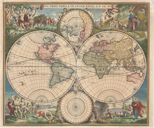
Auction 148, Lot 23
Subject: World
Wit, Frederick de
Nova Orbis Tabula, in Lucem Edita, 1675
Size: 22.5 x 18.9 inches (57.2 x 48 cm)
Estimate: $4,750 - $5,500
De Wit's Stunning Double-Hemisphere Map with Gilt Highlights
Sold for: $3,250
Closed on 2/19/2014
Auction 148, Lot 24
Subject: World
Pitt, Moses
Nova Totius Terrarum Orbis Geographica ac Hydrographica Tabula, 1680
Size: 21 x 15.7 inches (53.3 x 39.9 cm)
Estimate: $11,000 - $13,000
Pitt's Rare Carte-a-Figures Map in Full Original Color
Sold for: $6,500
Closed on 2/19/2014
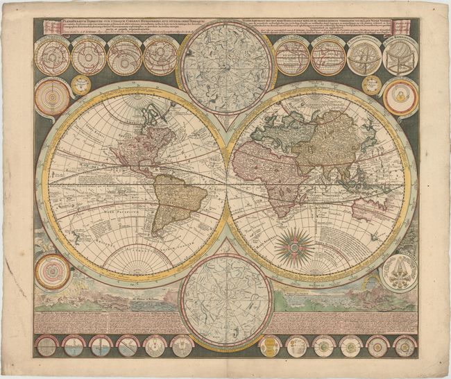
Auction 148, Lot 27
Subject: World
Zurner/Schenk
Planisphaerium Terrestre cum Utroque Coelesti Hemisphaerio, sive Diversa Orbis Terraquei... / Vlakke Aard-Kloot met het Beide Hemelsch Half-Rond, of de Onderscheidene Verbeelding van de Land-Water-Waereld…, 1700
Size: 22.6 x 19.8 inches (57.4 x 50.3 cm)
Estimate: $4,500 - $5,500
World Map with Astronomical Diagrams and Illustrations of Natural Phenomena
Sold for: $3,250
Closed on 2/19/2014
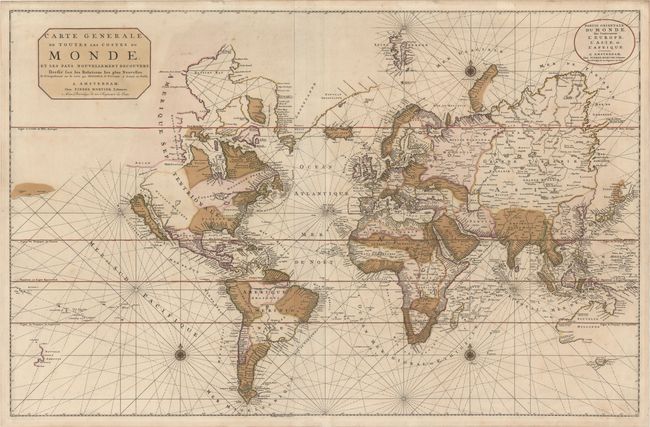
Auction 148, Lot 28
Subject: World
Mortier, Pierre
Carte Generale de Toutes les Costes du Monde, et les Pays Nouvellement Decouvert, Dressee sur les Relations les Plus Nouvelles..., 1700
Size: 35.6 x 23.1 inches (90.4 x 58.7 cm)
Estimate: $3,500 - $4,500
Large-Scale World Map with California as and Island and Interesting Great Lakes Formation
Sold for: $2,500
Closed on 2/19/2014
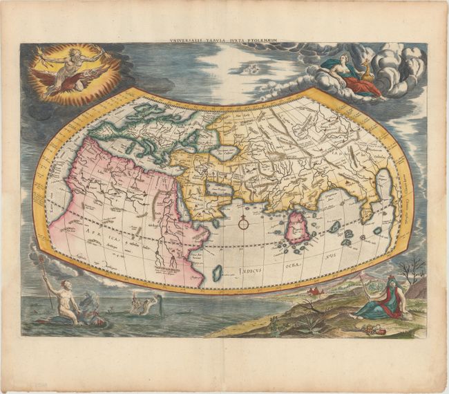
Auction 148, Lot 42
Subject: Ancient World
Ptolemy/Mercator
Universalis Tabula Iuxta Ptolemaeum, 1730
Size: 18.7 x 13.7 inches (47.5 x 34.8 cm)
Estimate: $2,750 - $3,500
Ancient Map of the World with Depictions of the Four Elements
Unsold
Closed on 2/19/2014
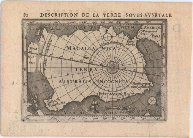
Auction 148, Lot 49
Subject: South Pole
Hondius/Bertius
Description de la Terre Soubs-Australe, 1618
Size: 5.3 x 3.8 inches (13.5 x 9.7 cm)
Estimate: $550 - $700
One of the First Maps to Focus on the South Pole
Sold for: $1,000
Closed on 2/19/2014
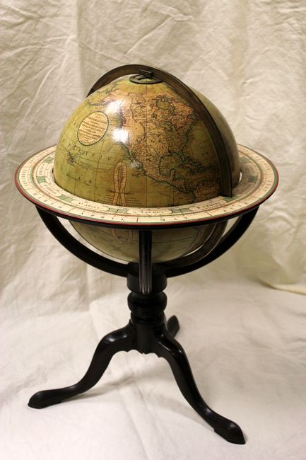
Auction 148, Lot 53
Subject: Globes
Cary, John
[12 Inch Globe] Cary’s New Terrestrial Globe Delineated from the Best Authorities…, 1800
Size: 17 x 24 inches (43.2 x 61 cm)
Estimate: $9,000 - $11,000
Magnificent Early Cary Brothers Globe
Sold for: $6,000
Closed on 2/19/2014
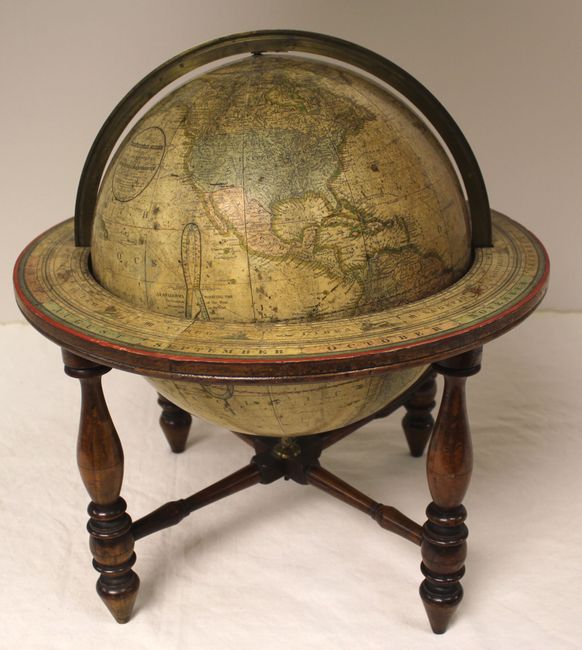
Auction 148, Lot 54
Subject: Globes
Joslin, Gilman
[12-Inch Globe] Loring's Terrestrial Globe Containing All the Late Discoveries and Geographical Improvements…, 1846
Size: 16 x 19 inches (40.6 x 48.3 cm)
Estimate: $8,000 - $10,000
One of the Earliest Globes to Depict the Southwest as a U.S. Possession
Unsold
Closed on 2/19/2014
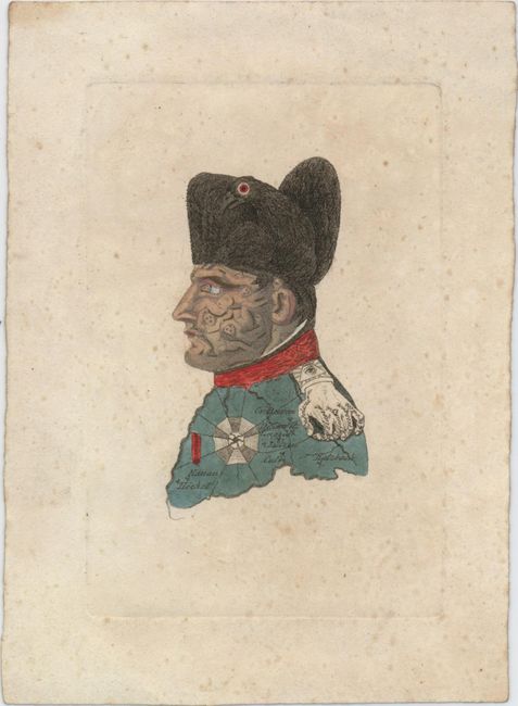
Auction 148, Lot 56
Subject: Cartographic Miscellany, Napoleon, Germany
[Untitled - Napoleon Bonaparte Portrait], 1814
Size: 2.1 x 3.7 inches (5.3 x 9.4 cm)
Estimate: $600 - $750
Famous Caricature of Napoleon
Sold for: $350
Closed on 2/19/2014
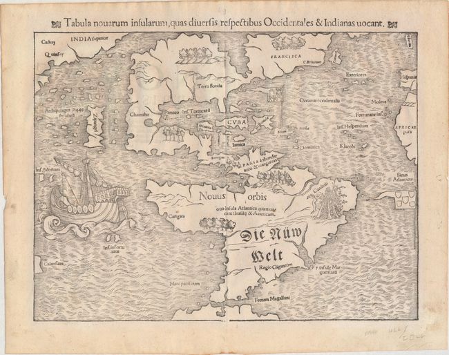
Auction 148, Lot 61
Subject: Western Hemisphere
Munster, Sebastian
Tabula Novarum Insularum, quas Diversis Respectibus Occidentales & Indianas Vocant, 1559
Size: 13.4 x 10.6 inches (34 x 26.9 cm)
Estimate: $5,500 - $6,500
One of the Most Important 16th Century Maps of the New World
Sold for: $5,000
Closed on 2/19/2014
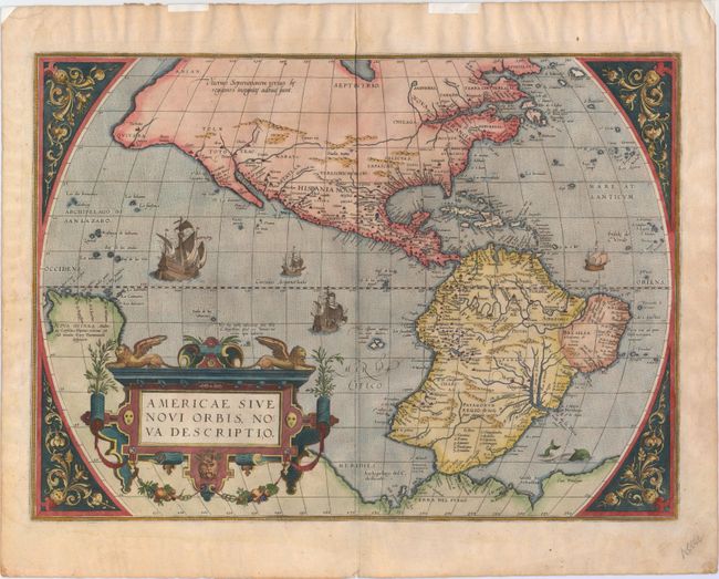
Auction 148, Lot 62
Subject: Western Hemisphere
Ortelius, Abraham
Americae Sive Novi Orbis, Nova Descriptio, 1579
Size: 19.6 x 14.2 inches (49.8 x 36.1 cm)
Estimate: $6,000 - $7,500
Ortelius' Influential Map of the New World - Second Plate
Sold for: $5,000
Closed on 2/19/2014
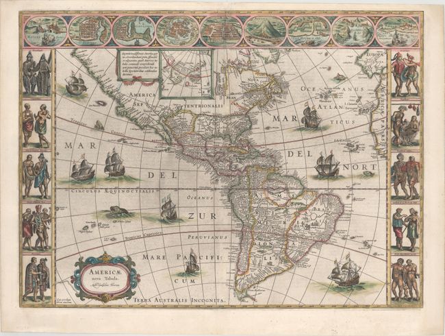
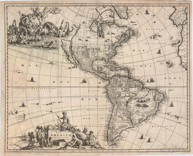
Auction 148, Lot 63
Subject: Western Hemisphere
Blaeu, Willem
Americae Nova Tabula, 1647
Size: 22 x 16.3 inches (55.9 x 41.4 cm)
Estimate: $6,000 - $7,000
Blaeu's Stunning Carte-a-Figures Map of the Americas
Sold for: $3,800
Closed on 2/19/2014
Auction 148, Lot 66
Subject: Western Hemisphere - America
Meurs, Jacob van
Novissima et Accuratissima Totius Americae Descriptio, 1673
Size: 21 x 16.8 inches (53.3 x 42.7 cm)
Estimate: $2,200 - $2,750
Meur's Decorative Map of the Americas with California as an Island
Unsold
Closed on 2/19/2014
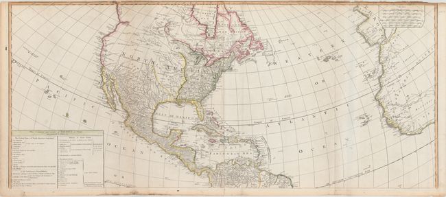
Auction 148, Lot 75
Subject: Western Hemisphere
Laurie & Whittle
A New Map of the Whole Continent of America, Divided into North and South and West Indies wherein are Exactly Described the United States of North America..., 1794
Size: 46.8 x 40.5 inches (118.9 x 102.9 cm)
Estimate: $1,500 - $2,000
Impressive Four-Sheet Map Featuring Two Possible Locations for a River of the West
Sold for: $1,100
Closed on 2/19/2014
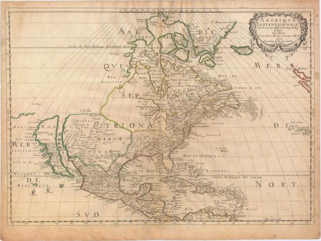
Auction 148, Lot 77
Subject: North America
Sanson/Mariette
Amerique Septentrionale par N. Sanson d'Abbeville…, 1650
Size: 22 x 15.5 inches (55.9 x 39.4 cm)
Estimate: $2,500 - $3,250
Important Map for Great Lakes Collectors
Sold for: $1,900
Closed on 2/19/2014
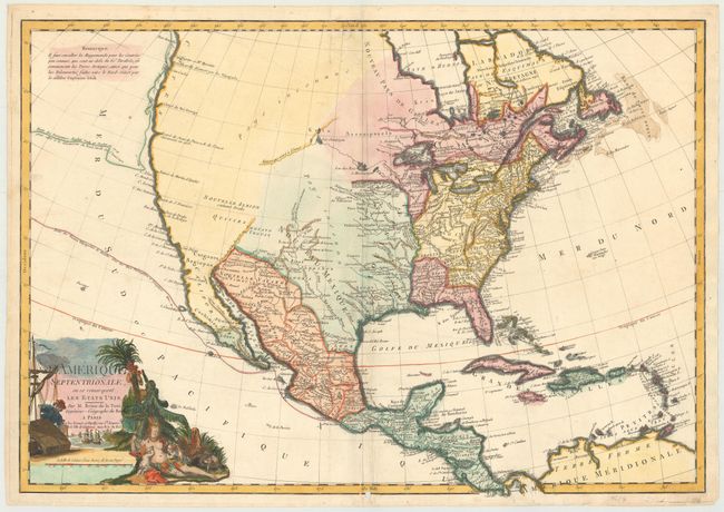
Auction 148, Lot 84
Subject: North America
Brion de la Tour, Louis
L'Amerique Septentrionale, ou se Remarquent les Etats Unis, 1783
Size: 28.8 x 20 inches (73.2 x 50.8 cm)
Estimate: $1,900 - $2,300
One of the Earliest Maps to Acknowledge the United States in the Title
Sold for: $1,400
Closed on 2/19/2014
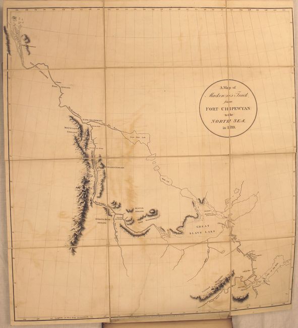
Auction 148, Lot 105
Subject: Canada
Mackenzie, Alexander
Voyages from Montreal, on the River St. Laurence, Through the Continent of North America, to the Frozen and Pacific Oceans; in the Years 1789 and 1793..., 1801
Size: 8.6 x 10.8 inches (21.8 x 27.4 cm)
Estimate: $5,500 - $6,500
First Edition of Mackenzie's Famous Account
Unsold
Closed on 2/19/2014
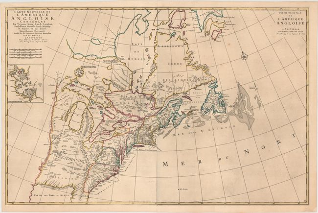
Auction 148, Lot 120
Subject: Colonial United States & Canada
Mortier, Pierre
Carte Nouvelle de l'Amerique Angloise Contenant la Virginie, Mary-Land, Caroline, Pensylvania, Nouvelle Iorck, N: Iarsey N: France, et les Terres Nouvellement Decouerte..., 1700
Size: 36 x 23.5 inches (91.4 x 59.7 cm)
Estimate: $3,500 - $4,250
A Map Showing Fascinating Geographic Misconceptions
Unsold
Closed on 2/19/2014
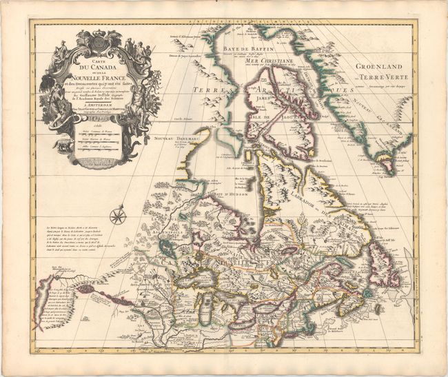
Auction 148, Lot 121
Subject: Colonial United States & Canada
Delisle/Covens & Mortier
Carte du Canada ou de la Nouvelle France et des Decouvertes qui y ont ete Faites..., 1730
Size: 22.6 x 19.3 inches (57.4 x 49 cm)
Estimate: $1,400 - $1,700
One of the Most Influential Maps of Canada, the Great Lakes and Upper Midwest
Sold for: $1,100
Closed on 2/19/2014
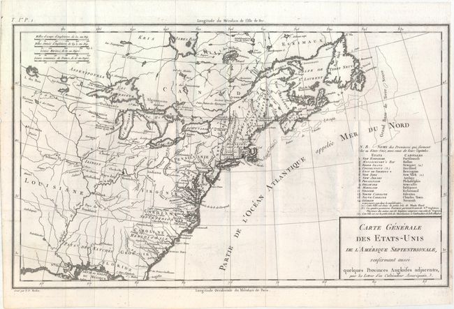
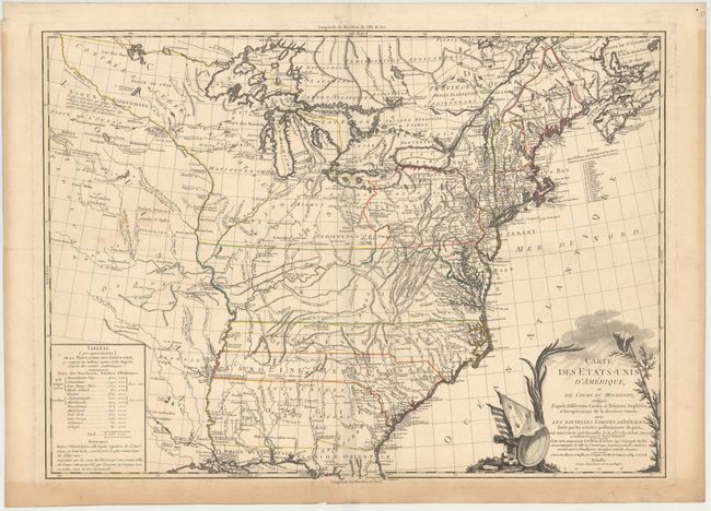
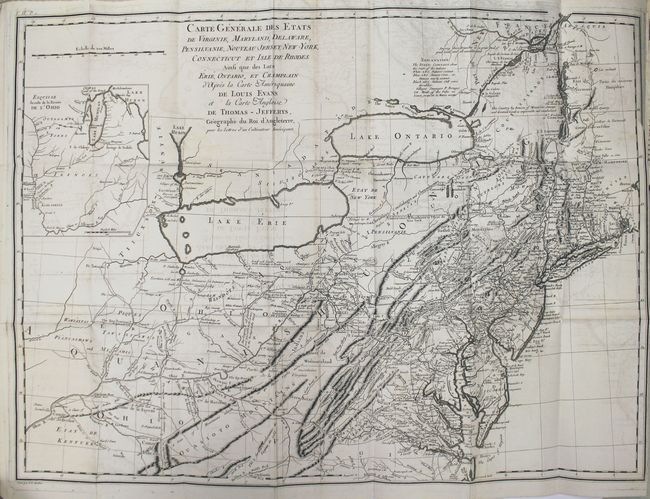
Auction 148, Lot 131
Subject: Eastern United States & Canada
Crevecoeur, Michel Guillaume De
Carte Generale des Etats-Unis de l'Amerique Septentrionale, Renfermant Aussi Quelques Provinces Angloises Adjacentes..., 1787
Size: 16.7 x 10.1 inches (42.4 x 25.7 cm)
Estimate: $600 - $800
First Printed Map to Name Franklinia
Sold for: $1,000
Closed on 2/19/2014
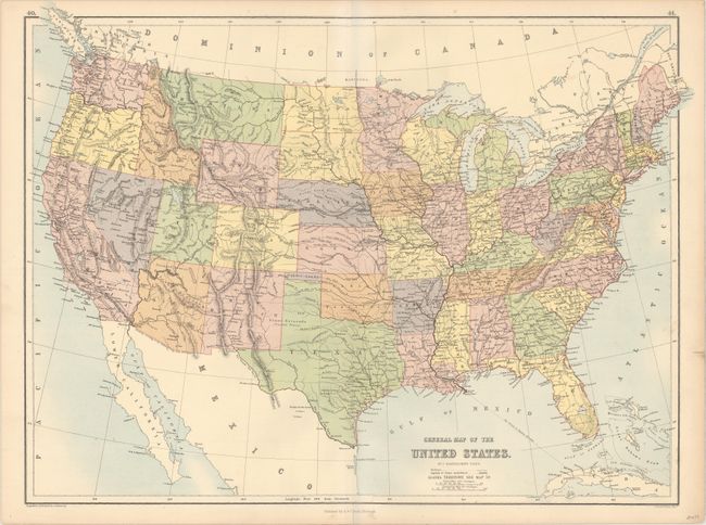
Auction 148, Lot 153
Subject: United States
Bartholomew, John
General Map of the United States, 1875
Size: 22.1 x 16.8 inches (56.1 x 42.7 cm)
Estimate: $300 - $400
Rare Map Depicting the Territory of Pembina
Sold for: $220
Closed on 2/19/2014

Auction 148, Lot 158
Subject: Colonial United States, Louisiana Territory
Delisle/Covens & Mortier
Carte de la Louisiane et du Cours du Mississipi Dressee sur un Grand Nombre de Memoires entr'autres sur ceux de Mr. le Maire, 1733
Size: 23.4 x 17.2 inches (59.4 x 43.7 cm)
Estimate: $2,750 - $3,500
Delisle's Influential Map of the Louisiana Territory
Sold for: $1,500
Closed on 2/19/2014
Auction 148, Lot 160
Subject: Eastern United States
Brion de la Tour, Louis
Carte des Etats-Unis d'Amerique et du Cours du Mississipi…, 1784
Size: 27.5 x 20 inches (69.9 x 50.8 cm)
Estimate: $2,500 - $3,500
One of the Earliest Maps of the New United States
Sold for: $1,500
Closed on 2/19/2014
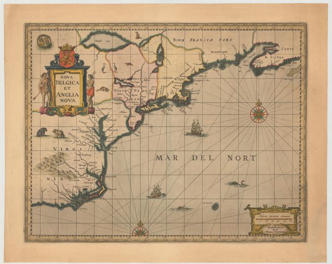
Auction 148, Lot 171
Subject: Colonial New England & Mid-Atlantic United States
Jansson/Valck & Schenk
Nova Belgica et Anglia Nova, 1694
Size: 19.5 x 15 inches (49.5 x 38.1 cm)
Estimate: $2,000 - $2,300
Jansson's Influential Map of the East Coast
Unsold
Closed on 2/19/2014
Auction 148, Lot 178
Subject: New England United States
Crevecoeur, Michel Guillaume De
[Three Volumes] Lettres d'un Cultivateur Americain Addressees a Wm. S... on Esqr. Depuis l'Annee 1770 Jusqu'en 1786..., 1787
Size: 5.1 x 8.1 inches (13 x 20.6 cm)
Estimate: $3,250 - $4,000
Crevecoeur's Classic Account on American Life
Sold for: $3,000
Closed on 2/19/2014
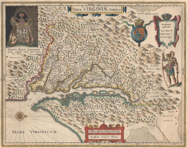
Auction 148, Lot 183
Subject: Colonial Mid-Atlantic United States
Hondius/Blaeu
Nova Virginiae Tabula, 1663
Size: 18.9 x 14.8 inches (48 x 37.6 cm)
Estimate: $2,750 - $3,500
One of the Most Important 17th Century Maps of the Chesapeake Bay
Sold for: $2,100
Closed on 2/19/2014
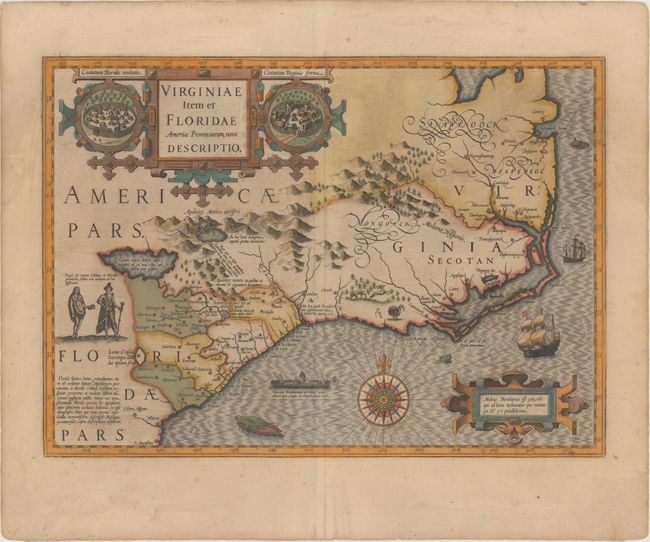
Auction 148, Lot 192
Subject: Colonial Southeast United States
Hondius, Jodocus
Virginiae Item et Floridae Americae Provinciarum, Nova Descriptio, 1619
Size: 19.1 x 13.5 inches (48.5 x 34.3 cm)
Estimate: $2,750 - $3,500
A Seminal Map of the Southeast and Early American Cartography
Sold for: $2,200
Closed on 2/19/2014
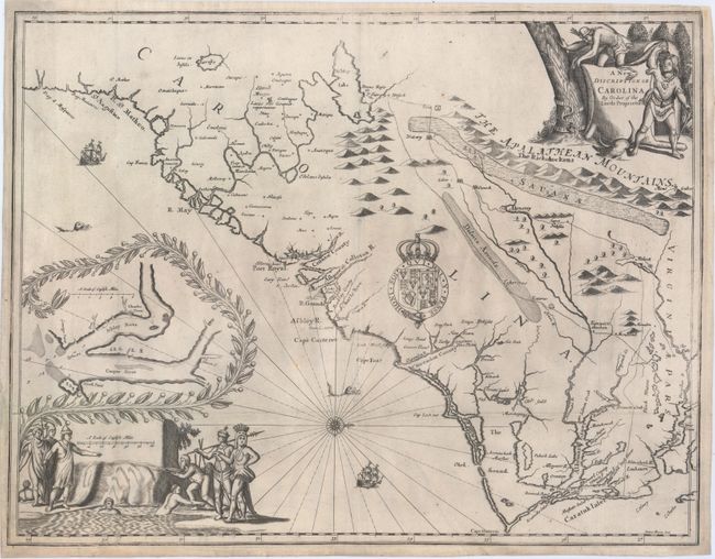
Auction 148, Lot 193
Subject: Colonial Southeast United States
Moxon/Ogilby
A New Discription of Carolina by Order of the Lords Proprietors, 1673
Size: 21.3 x 16.3 inches (54.1 x 41.4 cm)
Estimate: $12,000 - $15,000
Ogilby's Scarce and Influential First Lords Proprietors Map
Unsold
Closed on 2/19/2014
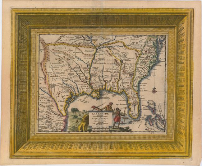
Auction 148, Lot 202
Subject: Colonial Southern United States
Aa, Pieter van der
La Floride, Suivant les Nouvelles Observations…, 1729
Size: 16 x 13.2 inches (40.6 x 33.5 cm)
Estimate: $1,700 - $2,000
Superb Picture Frame-Style Border
Sold for: $1,200
Closed on 2/19/2014
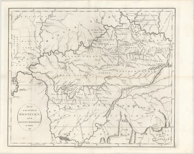
Auction 148, Lot 206
Subject: Tennessee, Kentucky
Russell, John C.
Map of the State of Kentucky; with the Adjoining Territories, 1794
Size: 18.1 x 14.9 inches (46 x 37.8 cm)
Estimate: $800 - $1,000
An Important Map of the Trans-Appalachian Frontier
Sold for: $425
Closed on 2/19/2014
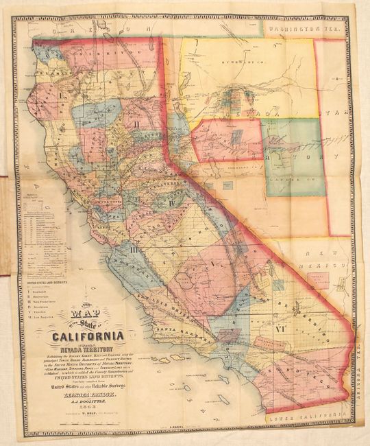
Auction 148, Lot 228
Subject: California, Nevada
Ransom & Doolittle
A New Map of the State of California and Nevada Territory..., 1863
Size: 21.5 x 26.3 inches (54.6 x 66.8 cm)
Estimate: $4,000 - $5,500
Early and Important Map of the Western Mining Districts
Sold for: $2,000
Closed on 2/19/2014
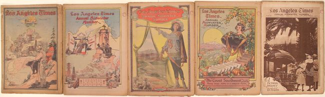
Auction 148, Lot 241
Subject: Southern California
[Lot of 5] Los Angeles Times Annual Midwinter Number Parts I-V, 1923
Size: 11.7 x 16.4 inches (29.7 x 41.7 cm)
Estimate: $300 - $400
L.A. Times Special Edition Promoting Southern California
Sold for: $450
Closed on 2/19/2014
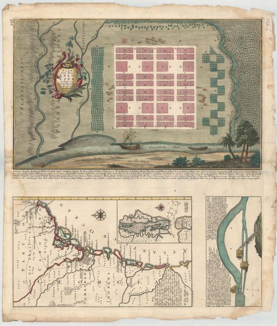
Auction 148, Lot 257
Subject: Georgia
Seutter, Matthias
Plan von Neu Ebenezer [on sheet with] [Untitled - Map of Southeast], 1747
Size: 19.8 x 12 inches (50.3 x 30.5 cm)
Estimate: $6,000 - $8,000
Rare Plan of Georgia Settlement New Ebenezer
Unsold
Closed on 2/19/2014
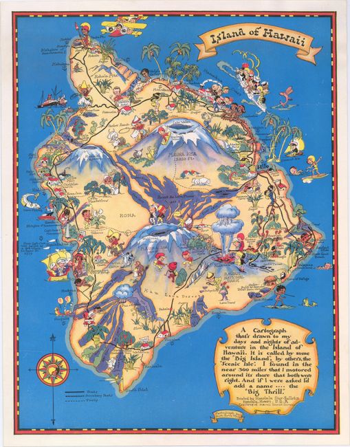
Auction 148, Lot 258
Subject: Hawaii
White, Ruth Taylor
[Lot of 4 - Island Maps], 1935
Size: 14.7 x 11.2 inches (37.3 x 28.4 cm)
Estimate: $400 - $500
Matched Set of Ruth White Hawaii Maps
Sold for: $220
Closed on 2/19/2014
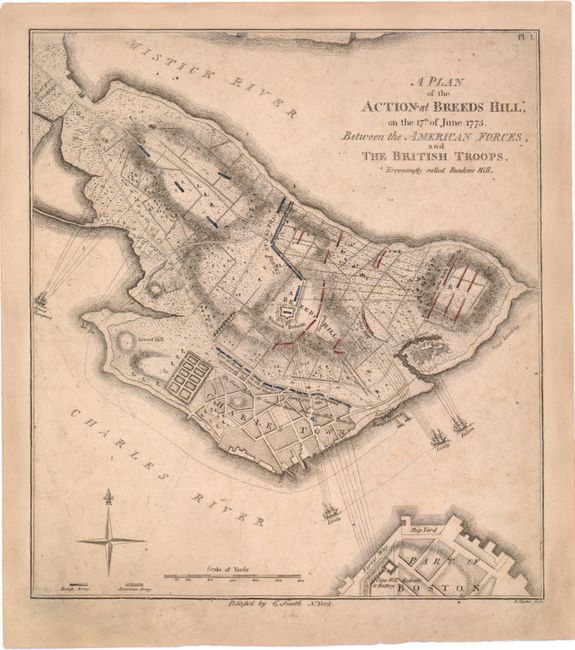
Auction 148, Lot 273
Subject: Boston, Massachusetts
Smith, Charles
A Plan of the Action at Breeds Hill*, on the 17th of June 1775. Between the American Forces, and the British Troops. *Erroneously Called Bunkers Hill, 1796
Size: 8.3 x 9.2 inches (21.1 x 23.4 cm)
Estimate: $2,750 - $3,500
The First Detailed Plan of the Battle of Bunker Hill Published in the United States
Sold for: $2,000
Closed on 2/19/2014
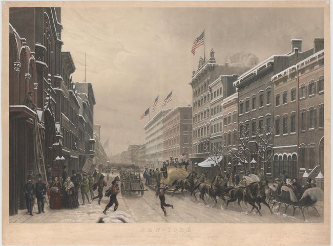
Auction 148, Lot 293
Subject: New York City, New York
Sebron, H.
New-York Winter Scene in Broadway / Scene d'Hiver dans Broadway, 1857
Size: 34 x 23.5 inches (86.4 x 59.7 cm)
Estimate: $2,000 - $2,300
Charming Scene of Broadway in Winter
Unsold
Closed on 2/19/2014
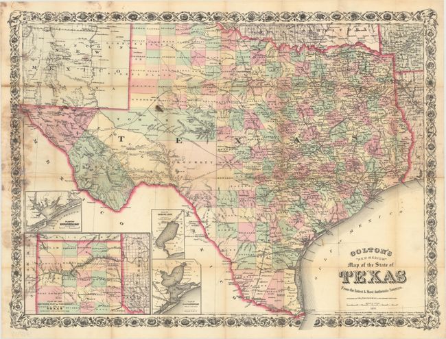
Auction 148, Lot 321
Subject: Texas
Colton, G.W. & C.B.
Colton's "New Medium" Map of the State of Texas from the Latest & Most Authentic Sources, 1879
Size: 25.5 x 19.3 inches (64.8 x 49 cm)
Estimate: $2,000 - $2,500
Rare Pocket Map of Texas
Unsold
Closed on 2/19/2014
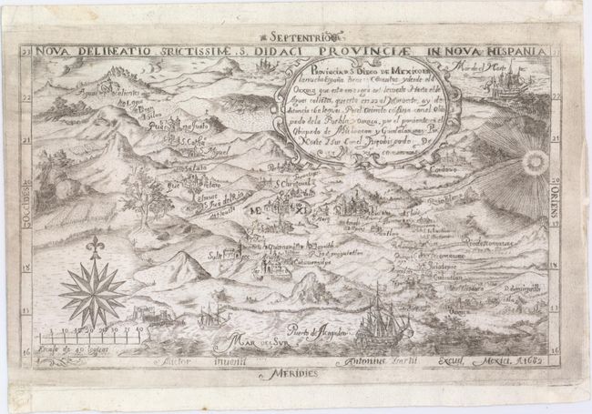
Auction 148, Lot 350
Subject: Central Mexico
Provincia d. S. Diego de Mexico en la Nueba Espana..., 1682
Size: 10.4 x 6.3 inches (26.4 x 16 cm)
Estimate: $5,500 - $6,500
One of the First Maps Published in Mexico
Unsold
Closed on 2/19/2014
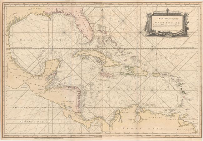
Auction 148, Lot 363
Subject: Gulf of Mexico & Caribbean
Sayer & Bennett
A New General Chart of the West Indies from the Latest Marine Journals and Surveys, Regulated and Ascertained by Astronomical Observations, 1779
Size: 40.2 x 27.3 inches (102.1 x 69.3 cm)
Estimate: $1,700 - $2,000
Detailed Chart of the Gulf of Mexico Showing Colonial Possessions
Sold for: $1,100
Closed on 2/19/2014
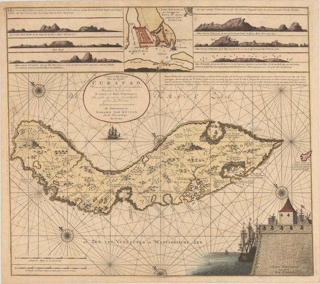
Auction 148, Lot 382
Subject: Curacao
Keulen, Gerard van
Nieuwe Afteekening van het Eyland Curacao..., 1728
Size: 23.3 x 20.6 inches (59.2 x 52.3 cm)
Estimate: $8,000 - $9,000
One of the Earliest Detailed Maps of Curacao
Unsold
Closed on 2/19/2014
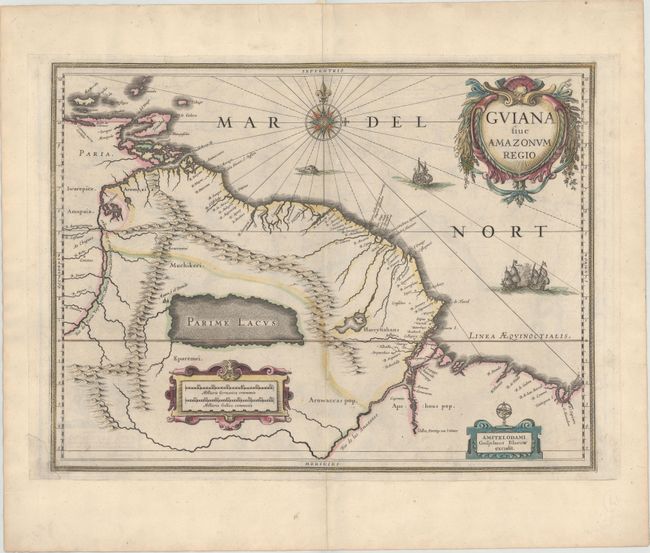
Auction 148, Lot 402
Subject: Guyana, Suriname, French Guiana
Blaeu, Willem
Guiana sive Amazonum Regio, 1642
Size: 19.4 x 14.7 inches (49.3 x 37.3 cm)
Estimate: $400 - $500
Unique Example with an Interesting Printing Error
Unsold
Closed on 2/19/2014
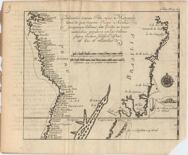
Auction 148, Lot 410
Subject: Central South America
Anon.
Delineatio Orarum Peru Cujus Metropolis Lima in qua Vicarius Regis Archiepiscopusque Habitant haec Civita ex Varys Nationibus Populosa est las Salinas..., 1725
Size: 6.6 x 5.4 inches (16.8 x 13.7 cm)
Estimate: $800 - $1,000
Rare Map Depicting Oliver van Noort's Voyage Around South America
Unsold
Closed on 2/19/2014
75 lots
Page 1 of 2