Subject: Western Hemisphere
Period: 1559 (published)
Publication: Cosmographia
Color: Black & White
Size:
13.4 x 10.6 inches
34 x 26.9 cm
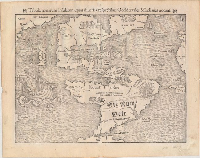
This map of the New World is often credited with popularizing the name America due to the popularity of Munster's Cosmographia and the numerous editions published in the sixteenth century. The influence of Marco Polo's 13th century explorations in Asia are evident with the 7448 islands in the North Pacific and Zipangri (Japan) shown only a short distance off the western coast of North America. The North American continent is very oddly shaped without a California landmass and the eastern region is nearly bisected by a body of water, known as the Sea of Verrazzano. The Yucatan is still shown as an island, Cozumel is named nearby as Cozumela, and the lake at Temistitan (not named in this state) is connected to the Gulf of Mexico. South America has a large bulge on the western coast, the Amazon River is very short, and cannibals inhabit the continent shown with the name Canibali next to a gruesome vignette with human limbs. The map is very decorative with Magellan's surviving ship Victoria appearing in the Pacific. The flags of Spain and Portugal depict their respective spheres of influence in the New World. This is the 10th state per Burden and the 9th state per Kershaw, without the place name Temistitan but with the lost stereotype Sciana now replaced in italics on the Caribbean island that holds the Royal Standard.
References: Burden #12, state 10; Kershaw #9.
Condition: A
Minor marginal soiling and a couple of small, insignificant spots.