Subject: Colonial Southeast United States
Period: 1673 (circa)
Publication:
Color: Black & White
Size:
21.3 x 16.3 inches
54.1 x 41.4 cm
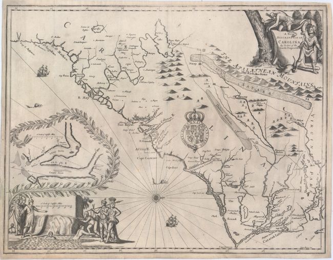
The first few printings of John Ogilby's America contained Montanus' map of the Carolinas, which was based on Blaeu's map circa 1638. Once it was resolved that America would be used as a promotional tool to encourage settlement in Maryland and the Carolinas, Ogilby decided that new maps of these two areas were required. Ogilby relied on numerous sources to ensure that his map of the Carolinas was the most up-to-date, including John Lederer, William Hilton, Robert Sandford, John Culpeper, and the Ashley-Cooper manuscript map (as evidenced in the inset map at far left). The interior of the map was heavily influenced by Lederer, including several misconceptions, such as the large lake named Ashley Lake, the Savanae (savanna) running the length of the Apalathean Mountains, and a desert named Deserta Arenola. It was chiefly through this popular map that Lederer's errors became quickly disseminated and so widely copied.
Much of the nomenclature on the map represents the names of the Lords Proprietors, including the Earl of Clarendon, the Duke of Albemarle, Sir George Carteret, Sir William Berkeley, and Anthony, Lord Ashley. In 1663 under the reign of Charles II, eight Lords Proprietors were granted control of the region between 31 and 36 degrees latitude, in the hopes of creating a new colony. Settlement was slow and more expeditions in the area were required to better understand the land. The Lords Proprietors organized expeditions of the region and sought ways to convince settlers to come to the fledgling colony. In 1670 Ogilby approached the Lords Proprietors both for assistance in mapping the Carolinas and for a written account of the area. The Lords Proprietors were eager to assist and supplied both cartographic material and a promotional account, which was apparently written by John Locke, the secretary of Lord Ashley. As a result of their involvement, this landmark map is known as the First Lords Proprietors Map.
Drawn and engraved by James Moxon, the map is also significant for the first appearance of the Pamlico (Pemptico) River and the Pasquotank (Paskotank) River. Despite the misconceptions copied from Lederer, the map presented a great improvement over previously published maps of the region. It served as the basis of Francis Lamb's map published in the final edition of Speed's Prospect… in 1676, as well as numerous other maps for another 30 years, despite the publication of Gascoyne's Second Lords Proprietors Map in 1682.
Oriented with north to the right, this scarce map is splendidly embellished with a title cartouche featuring two Native Americans, a distance scale surrounded by a group of natives, the arms of Charles II, a compass rose, ships and sea monsters. First published in Ogilby's America, the map was later included in a promotional tract by Samuel Wilson (the proprietor's secretary) titled An Account of the Province of Carolina in 1682, and was likely issued separately as well.
References: Burden #435; Cumming (SE) #70; Williams & Johnson #5.
Condition: B+
Issued folding, now flattened, on watermarked paper with a few separations and tiny tears along the bottom fold that have been professionally repaired. Tears that enter 1" into map at top left and bottom right have also been professionally repaired. There are a few minor printer's creases and faint soiling.