Subject: World
Period: 1511 (published)
Publication: Claudii Ptholemaei Alexandrini liber geographiae cum tabulis…
Color: Hand Color
Size:
22 x 16.3 inches
55.9 x 41.4 cm
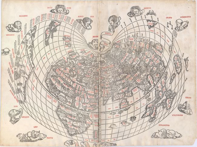
This rare and distinctive "modern" world map, from the 1511 edition of Ptolemy's Geograhia, is an extremely early example of 16th century Venetian cartography and one of the earliest maps obtainable by today's collectors. This Latin edition of Ptolemy was the first published in Venice, by Jacobus Pentius de Leucho, and was the first atlas to use two-color woodblock printing. The maps were printed in black with place names and headings printed in red ink by means of type set into the woodblock and applied with a second strike of the plate. The text was based on a Latin translation by Jacobus Angelus, with revised maps by Bernardus Sylvanus. Little is known of Sylvanus, a native of Southern Italy, although he is believed to have been a monk. Realizing that Ptolemy's maps were outdated, Sylvanus set out to update them with modern information, often from contemporary manuscript sources. The resulting effect was an unusual hybrid of classical and modern information. Sylvanus also introduced a new world map, depicted for the first time in a distinctive cordiform (heart-shaped) projection, which was adopted by several later cartographers and used for a number of important 16th century maps.
This world map was the first to show the newly discovered Americas in an edition of Ptolemy's Geograhia, and presents a fascinating view of the post-Columbian world. South America, of which only the eastern coast is shown, is named Terra Sanctae Crucis but bears no additional place names. The islands of Cuba and Hispanola appear overly large and surrounded by numerous small, unnamed islands. Further north and quite close to Ireland are the island Terra Laboratorus and a partially delineated region named Regalis Domus, resulting from the Portuguese explorations of the Corte Real brothers in 1501. On the opposite side of the map the island of Zampagv (Japan), which appears for only the second time on a printed map. The first appearance being on the Contarini/Rosselli map of 1506, of which there is only one known copy. The land masses are vigorously engraved with mountain ranges, rivers and place names, and the map is surrounded by decorative wind heads and signs of the zodiac. Printed on two sheets, joined.
References: Shirley #32; Lutz #2; Mickwitz & Miekkavaara #204-1.
Condition: B
A nice impression with light soiling, about 10 small worm holes (most only visible when held to light), and a couple of small chips along sheet edge at right, far from image. The bottom wind head has been partially cut off, apparently as issued as the top margin is quite ample. The two sheets have been professionally rejoined with about 1/4" wide strip of the image of the left-hand sheet missing along the joint.