Subject: Eastern United States
Period: 1784 (dated)
Publication:
Color: Hand Color
Size:
27.5 x 20 inches
69.9 x 50.8 cm
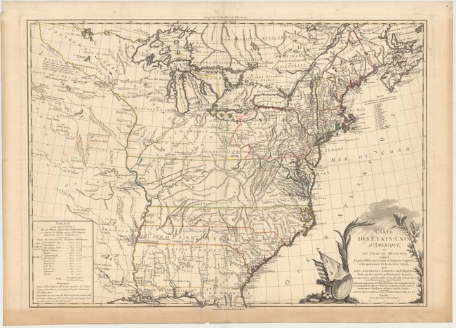
The Treaty of Paris, which ended the Revolutionary War, brought on the publication of a number of maps of the new United States and this map was among the earliest French maps to show the new nation. First published in 1783, this is the second state, dated 1784, but apparently unchanged from the first state. The map shows the nation's boundary on the Mississippi River, but extends to include considerable information on the Indian tribes on the western frontier as far as present-day Kansas (Kanfez). The states of Virginia, North Carolina, South Carolina and Georgia all have their western borders on the Mississippi River. There is excellent detail of early settlements, forts, and Indian villages with a list of 18 important forts in the New England region. A table at lower left gives the population for the original 13 states. A section of Virginia is named Indiana. This region was originally granted to a Philadelphia trading company by the Iroquois Confederacy in 1768. Then in 1776 it was sold to the Indiana Land Company, but was also claimed by the State of Virginia as a part of her original charter. The resulting battle between the private land company and Virginia resulted in the Eleventh Amendment to the U.S. Constitution and is one of the most interesting chapters in the history of the young United States. The large title cartouche is framed by a Liberty cap on a pikestaff, emblem of the Sons of Liberty, and the flags of the United States and France.
References: McCorkle #784.2; Sellers & Van Ee #746; Ristow, p. 63.
Condition: B+
Nice impression and original color on sturdy, watermarked paper. There is a faint horizontal extraneous crease where the map was folded, a few small spots in the image, and light toning primarily confined to the lower blank margin.