Showing Featured Lots(remove filter)
Filtered by Category:Canada(Show All Categories)
Catalog Archive
381 lots
Page 1 of 8
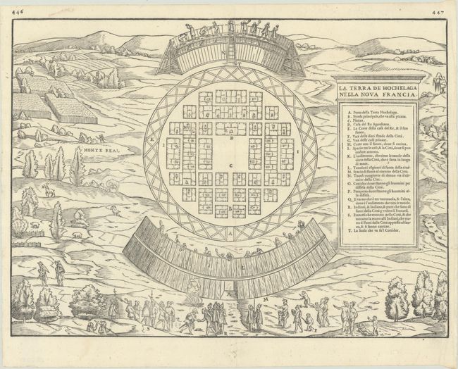
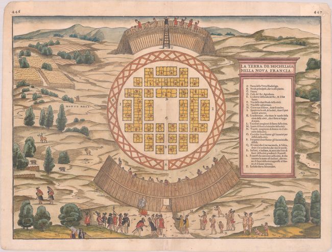
Auction 208, Lot 113
Subject: Montreal, Canada
Gastaldi/Ramusio
La Terra de Hochelaga nella Nova Francia, 1565
Size: 14.4 x 10.6 inches (36.6 x 26.9 cm)
Estimate: $3,000 - $3,750
The First Published Plan of a Settlement in North America
Sold for: $2,200
Closed on 4/22/2026
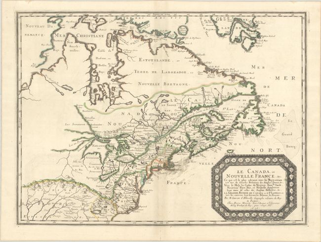
Auction 208, Lot 117
Subject: Colonial Eastern United States & Canada
Sanson/Mariette
Le Canada, ou Nouvelle France, &c. ce qui est le Plus Advance Vers le Septentrion est Tire de Diverses Relations des Anglois, Danois, &c..., 1656
Size: 21.4 x 15.9 inches (54.4 x 40.4 cm)
Estimate: $4,000 - $4,750
Keystone Map for Great Lakes Collections
Unsold
Closed on 4/22/2026
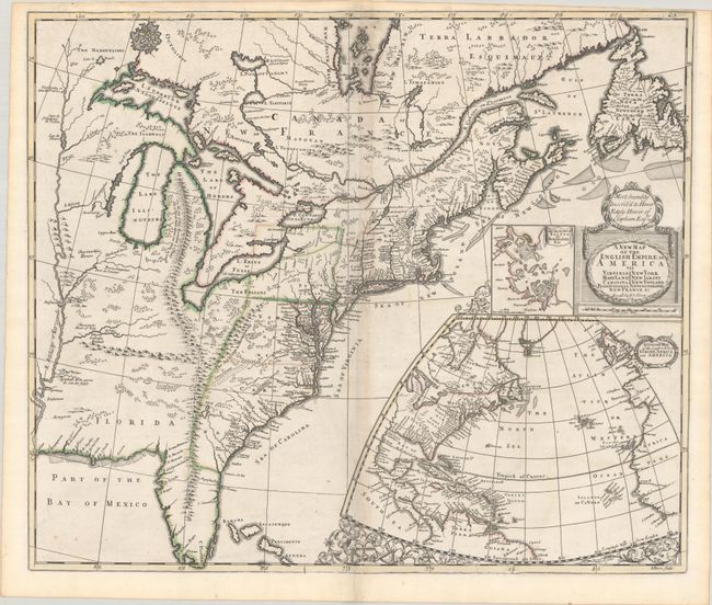
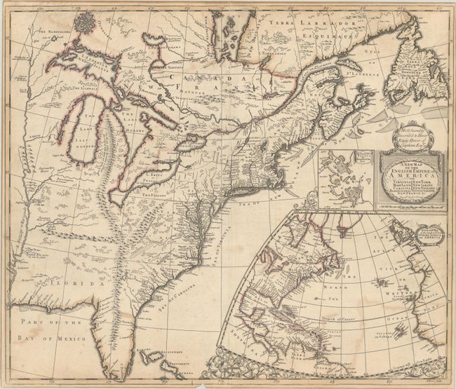
Auction 208, Lot 119
Subject: Colonial Eastern United States & Canada
Senex, John
A New Map of the English Empire in America viz Virginia Maryland Carolina Pennsylvania New York New Iarsey New England Newfoundland New France &c., 1719
Size: 22.9 x 19.6 inches (58.2 x 49.8 cm)
Estimate: $2,000 - $2,300
Senex's Important Map of the American Colonies
Sold for: $1,500
Closed on 4/22/2026
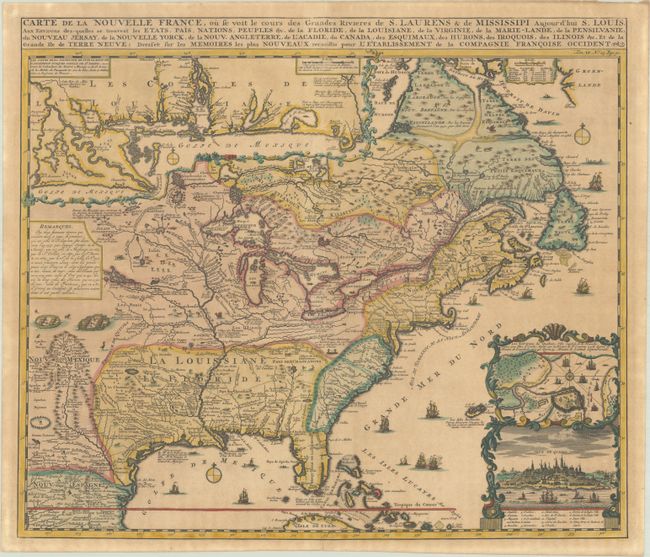
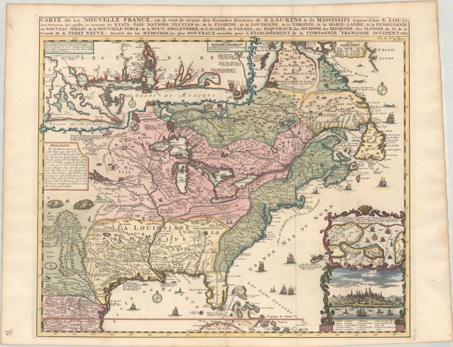
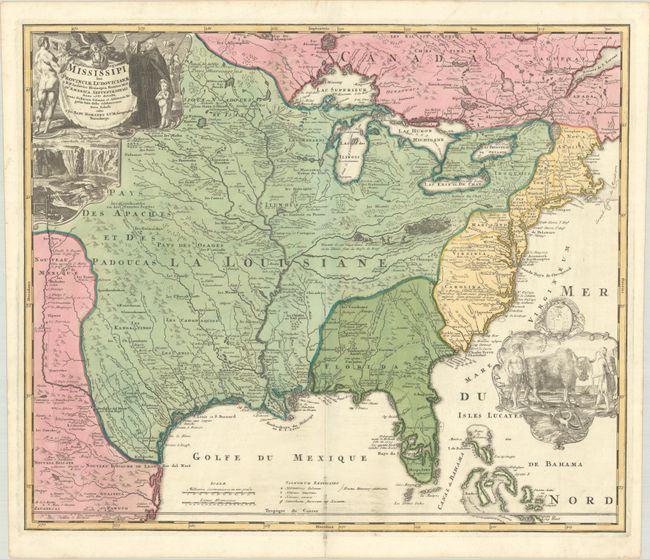
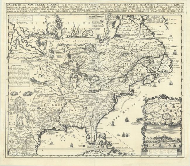
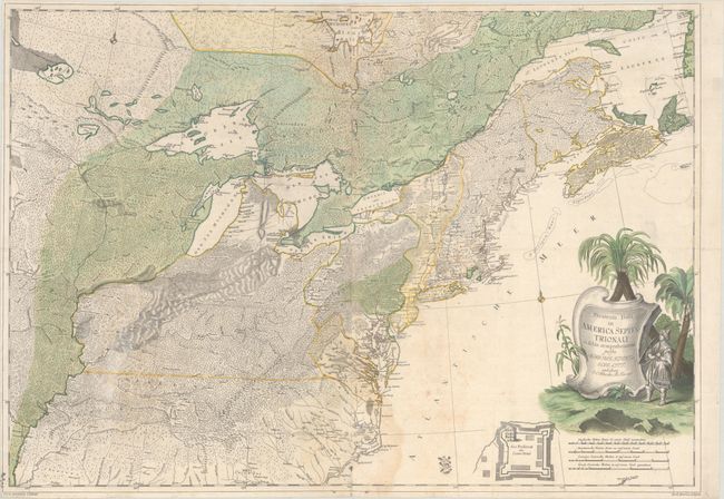
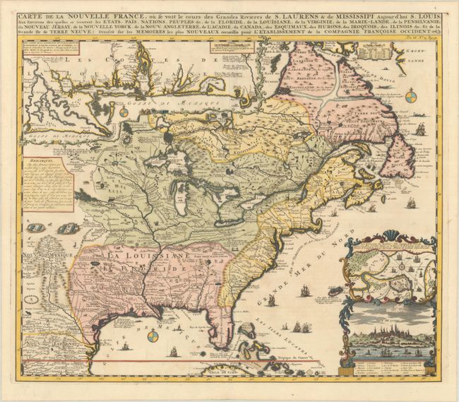
Auction 208, Lot 120
Subject: Colonial Eastern United States & Canada
Chatelain, Henry Abraham
Carte de la Nouvelle France, ou se voit les Cours des Grandes Rivieres de S. Laurens & de Mississipi Aujour d'hui S. Louis, aux Environs des-quelles se Trouvent les Etats, Pais, Nations, Peuples &c. de la Floride, de la Louisiane, de la Virginie..., 1719
Size: 19.4 x 16.6 inches (49.3 x 42.2 cm)
Estimate: $2,400 - $3,000
One of the Most Informative 18th-Century Maps of the French Possessions in North America
Unsold
Closed on 4/22/2026
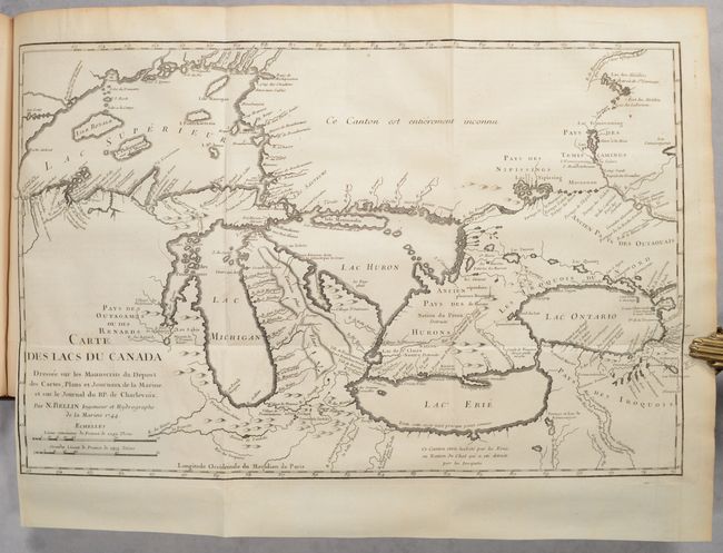
Auction 208, Lot 121
Subject: Colonial Eastern United States & Canada
Charlevoix, P. F. Xavier de
Journal d'un Voyage Fait par Ordre du Roi dans l'Amerique Septentrionale ... Tome Troisieme, 1744
Size: 8.5 x 10.6 inches (21.6 x 26.9 cm)
Estimate: $2,000 - $2,300
Volume III of Charlevoix's Travels Through Colonial North America, with Bellin's Important Map of the Great Lakes
Sold for: $1,500
Closed on 4/22/2026

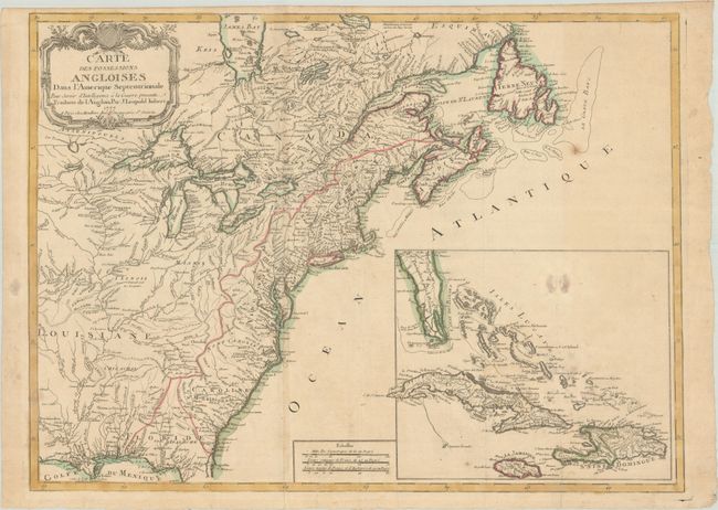
Auction 208, Lot 123
Subject: Colonial Eastern United States & Canada
Imbert, J. Leopold
Carte des Possessions Angloises dans l'Amerique Septentrionale pour Servir d'Intelligence a la Guerre Presente Traduite de l'Anglois, 1777
Size: 29 x 21.3 inches (73.7 x 54.1 cm)
Estimate: $1,500 - $1,800
First Edition of Important Revolutionary War Map
Unsold
Closed on 4/22/2026
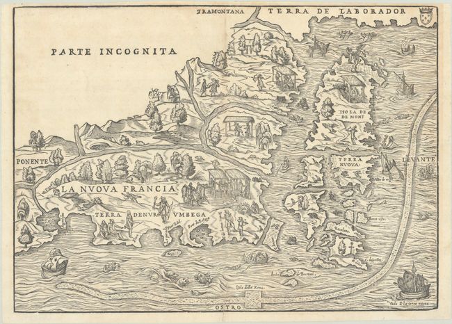
Auction 208, Lot 127
Subject: Colonial Northeastern United States & Canada
Gastaldi/Ramusio
La Nuova Francia, 1565
Size: 14.6 x 10.6 inches (37.1 x 26.9 cm)
Estimate: $4,500 - $5,500
The First Printed Map to Focus on New England and New France
Sold for: $4,250
Closed on 4/22/2026
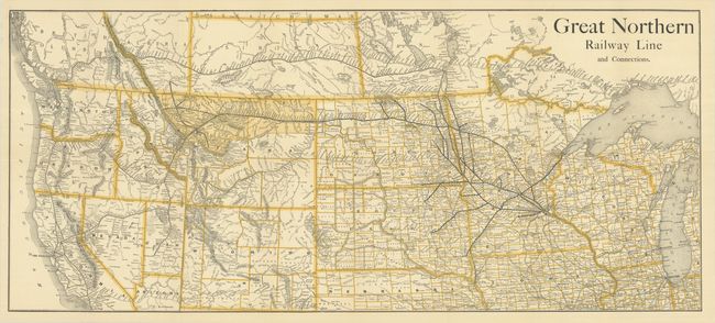
Auction 208, Lot 137
Subject: Western United States & Canada, Railroads
Railroad Companies, (Various)
Great Northern Railway Line and Connections, 1890
Size: 35.6 x 15.6 inches (90.4 x 39.6 cm)
Estimate: $250 - $325
Scarce Railroad Map with Bizarre Depictions of Montana and Wyoming. Colorado Is Off the Map!
Sold for: $180
Closed on 4/22/2026
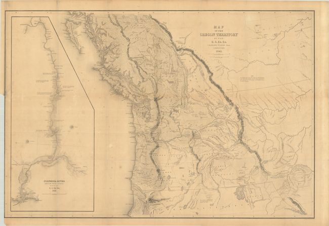
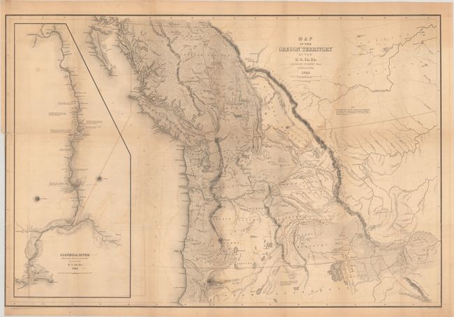
Auction 208, Lot 138
Subject: Northwestern United States & Canada
Wilkes, Charles
Map of the Oregon Territory by the U.S. Ex. Ex., 1841
Size: 34.3 x 23 inches (87.1 x 58.4 cm)
Estimate: $1,400 - $1,700
One of the Most Detailed and Important 19th-Century Maps of the American Northwest
Sold for: $1,000
Closed on 4/22/2026
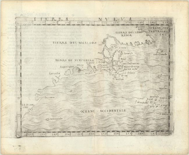
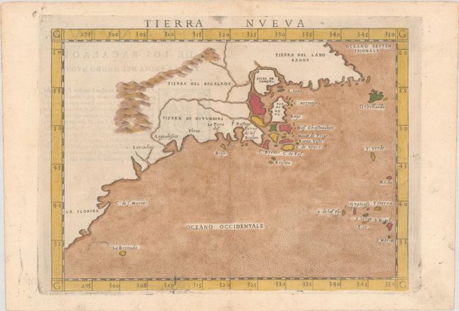
Auction 207, Lot 114
Subject: Eastern United States & Canada
Gastaldi, Giacomo
Tierra Nueva, 1548
Size: 6.8 x 5 inches (17.3 x 12.7 cm)
Estimate: $3,500 - $4,250
The First Published Map Devoted to the East Coast of North America
Sold for: $2,500
Closed on 2/11/2026
Auction 207, Lot 116
Subject: Colonial Eastern United States & Canada
Chatelain, Henry Abraham
Carte de la Nouvelle France, ou se Voit le Cours des Grandes Rivieres de S. Laurens & de Mississipi Aujour d'hui S. Louis, aux Environs des-quelles se Trouvent les Etats, Pais, Nations, Peuples &c. de la Floride, de la Louisiane, de la Virginie..., 1719
Size: 19.4 x 16.6 inches (49.3 x 42.2 cm)
Estimate: $2,300 - $2,750
One of the Most Informative 18th Century Maps of the French Possessions in North America
Sold for: $1,200
Closed on 2/11/2026
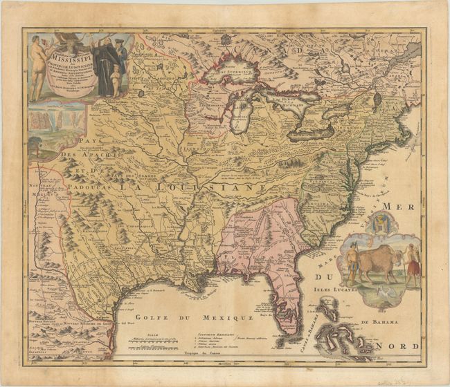
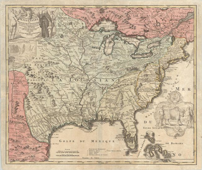
Auction 207, Lot 117
Subject: Colonial Eastern United States & Canada
Homann, Johann Baptist
Amplissimae Regionis Mississipi seu Provinciae Ludovicianae a R.P. Ludovico Hennepin Francisc Miss in America Septentrionali Anno 1687..., 1720
Size: 22.9 x 19.3 inches (58.2 x 49 cm)
Estimate: $2,000 - $2,300
Striking Map of Colonial America with Bison Vignette
Sold for: $1,100
Closed on 2/11/2026
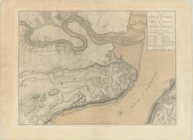
Auction 206, Lot 104
Subject: Quebec City, Canada
Faden, William
Plan of the City and Environs of Quebec, with Its Siege and Blockade by the Americans, from the 8th of December 1775 to the 13th of May 1776, 1776
Size: 24.3 x 17.4 inches (61.7 x 44.2 cm)
Estimate: $4,000 - $4,750
Important Revolutionary War Plan of Battle of Quebec in Contemporary Color
Sold for: $2,500
Closed on 11/12/2025

Auction 206, Lot 108
Subject: Colonial Eastern United States & Canada
Sanson/Mariette
Le Canada, ou Nouvelle France, &c. ce qui est le Plus Advance Vers le Septentrion est Tire de Diverses Relations des Anglois, Danois, &c..., 1656
Size: 21.4 x 15.9 inches (54.4 x 40.4 cm)
Estimate: $4,000 - $4,750
Keystone Map for Great Lakes Collections
Unsold
Closed on 11/12/2025

Auction 206, Lot 109
Subject: Colonial Eastern United States & Canada
Chatelain, Henry Abraham
Carte de la Nouvelle France, ou se Voit le Cours des Grandes Rivieres de S. Laurens & de Mississipi Aujour d'hui S. Louis, aux Environs des-quelles se Trouvent les Etats, Pais, Nations, Peuples, &c. de la Floride, de la Louisiane, de la Virginie..., 1719
Size: 19.3 x 16.7 inches (49 x 42.4 cm)
Estimate: $2,000 - $2,300
One of the Most Informative 18th Century Maps of the French Possessions in North America
Unsold
Closed on 11/12/2025

Auction 206, Lot 110
Subject: Colonial Eastern United States & Canada
Senex, John
A New Map of the English Empire in America viz Virginia Maryland Carolina Pennsylvania New York New Iarsey New England Newfoundland New France &c., 1719
Size: 22.9 x 19.6 inches (58.2 x 49.8 cm)
Estimate: $2,400 - $3,000
Senex's Important Map of the American Colonies
Unsold
Closed on 11/12/2025
Auction 206, Lot 111
Subject: Colonial Eastern United States & Canada
Homann, Johann Baptist
Amplissimae Regionis Mississipi seu Provinciae Ludovicianae a R.P. Ludovico Hennepin Francisc Miss. in America Septentrionali Anno 1687..., 1720
Size: 22.8 x 19.2 inches (57.9 x 48.8 cm)
Estimate: $2,200 - $2,500
Striking Map of Colonial America with Bison Vignette
Sold for: $2,500
Closed on 11/12/2025
Auction 206, Lot 115
Subject: Colonial Eastern United States & Canada
Imbert, J. Leopold
Carte des Possessions Angloises dans l'Amerique Septentrionale pour Servir d'Intelligence a la Guerre Presente Traduite de l'Anglois, 1777
Size: 29 x 21.3 inches (73.7 x 54.1 cm)
Estimate: $1,800 - $2,200
First Edition of Important Revolutionary War Map
Unsold
Closed on 11/12/2025
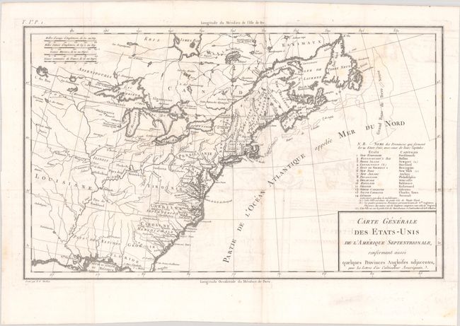
Auction 206, Lot 116
Subject: Eastern United States & Canada, Franklin
Crevecoeur, Michel Guillaume De
Carte Generale des Etats-Unis de l'Amerique Septentrionale, Renfermant Aussi Quelques Provinces Angloises Adjacentes, pour les Lettres d'un Cultivateur Ameriquain, 1787
Size: 16.9 x 10.3 inches (42.9 x 26.2 cm)
Estimate: $750 - $900
One of the Earliest Maps to Name Franklinia
Sold for: $475
Closed on 11/12/2025
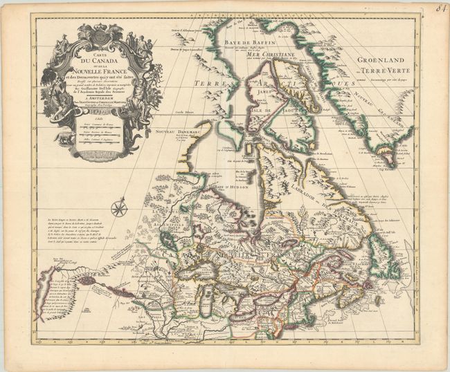
Auction 206, Lot 121
Subject: Colonial Northeastern United States & Canada
Delisle/Covens & Mortier
Carte du Canada ou de la Nouvelle France et des Decouvertes qui y ont ete Faites Dressee sur Plusieurs Observations et sur un Grand Nombre de Relations Imprimees ou Manuscrites, 1730
Size: 22.4 x 19.3 inches (56.9 x 49 cm)
Estimate: $1,200 - $1,500
One of the Most Influential Maps of Canada, Great Lakes & Upper Midwest
Sold for: $600
Closed on 11/12/2025
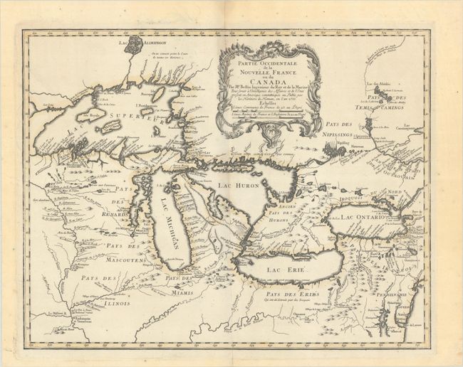
Auction 206, Lot 126
Subject: Colonial Great Lakes
Bellin/Homann Heirs
Partie Occidentale de la Nouvelle France ou du Canada, 1755
Size: 21.3 x 16.8 inches (54.1 x 42.7 cm)
Estimate: $1,500 - $1,800
Influential Map of the Great Lakes
Sold for: $1,000
Closed on 11/12/2025
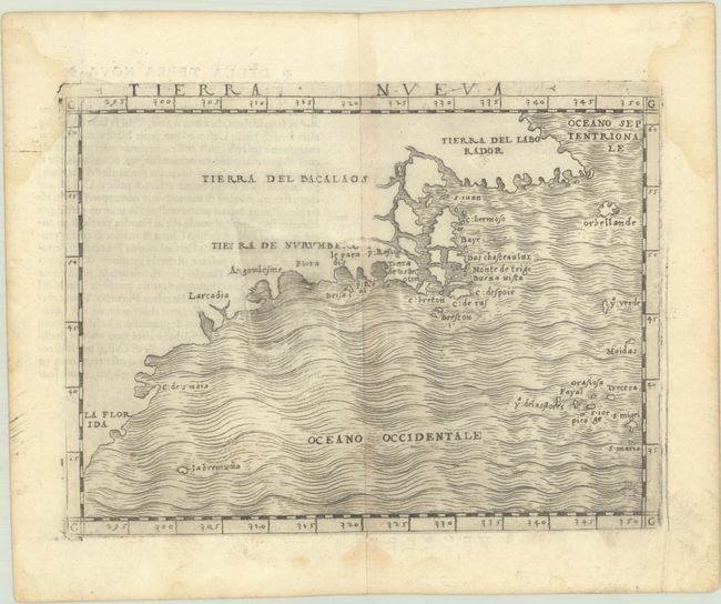
Auction 205, Lot 109
Subject: Eastern United States & Canada
Gastaldi, Giacomo
Tierra Nueva, 1548
Size: 6.8 x 5 inches (17.3 x 12.7 cm)
Estimate: $2,750 - $3,500
The First Published Map Devoted to the East Coast of North America
Sold for: $2,300
Closed on 9/10/2025
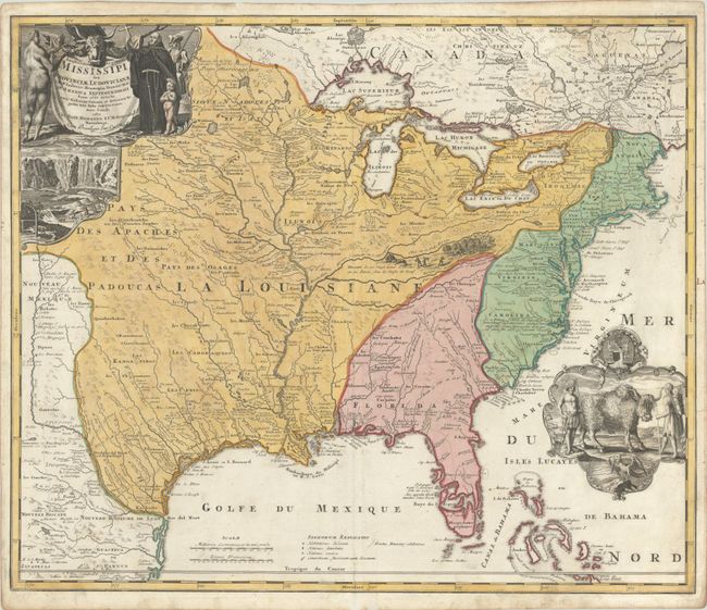
Auction 205, Lot 110
Subject: Colonial Eastern United States & Canada
Homann, Johann Baptist
Amplissimae Regionis Mississipi seu Provinciae Ludovicianae a R.P. Ludovico Hennepin Francisc Miss in America Septentrionali Anno 1687..., 1716
Size: 22.8 x 19.2 inches (57.9 x 48.8 cm)
Estimate: $2,200 - $2,500
Striking Map of Colonial America with Bison Vignette
Sold for: $1,600
Closed on 9/10/2025

Auction 205, Lot 111
Subject: Colonial Eastern United States & Canada
Chatelain, Henry Abraham
Carte de la Nouvelle France, ou se Voit le Cours des Grandes Rivieres de S. Laurens & de Mississipi Aujour d'hui S. Louis, aux Environs des-quelles se Trouvent les Etats, Pais, Nations, Peuples &c. de la Floride, de la Louisiane, de la Virginie..., 1719
Size: 19.4 x 16.6 inches (49.3 x 42.2 cm)
Estimate: $3,000 - $3,750
One of the Most Informative 18th Century Maps of the French Possessions in North America
Unsold
Closed on 9/10/2025
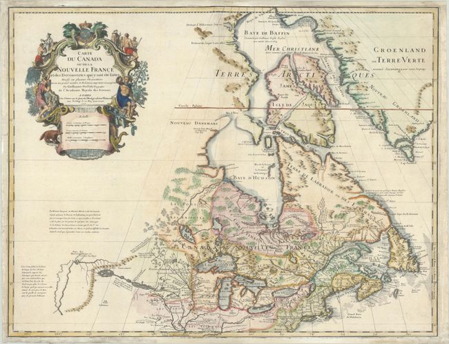
Auction 205, Lot 116
Subject: Colonial Northeastern United States & Canada, Great Lakes
Delisle, Guillaume
Carte du Canada ou de la Nouvelle France et des Decouvertes qui y ont ete Faites Dressee sur Plusieurs Observations et sur un Grand Nombre de Relations Imprimees ou Manuscrites, 1703
Size: 25.6 x 19.7 inches (65 x 50 cm)
Estimate: $1,900 - $2,200
Unrecorded State of Delisle's Seminal Map of Canada and the Great Lakes
Sold for: $1,400
Closed on 9/10/2025
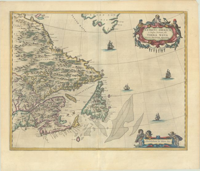
Auction 204, Lot 86
Subject: Eastern Canada
Blaeu, Johannes
Extrema Americae Versus Boream, ubi Terra Nova Nova Francia, Adjacentiaq, 1663
Size: 22.4 x 17.7 inches (56.9 x 45 cm)
Estimate: $1,800 - $2,100
Blaeu's Only Map of Canada, Showing the Canadian Maritimes
Sold for: $1,300
Closed on 6/18/2025
Auction 204, Lot 95
Subject: Colonial Eastern United States & Canada
Chatelain, Henry Abraham
Carte de la Nouvelle France, ou se Voit le Cours des Grandes Rivieres de S. Laurens & de Mississipi Aujour d'hui S. Louis, aux Environs des-quelles se Trouvent les Etats, Pais, Nations, Peuples, &c. de la Floride, de la Louisiane, de la Virginie..., 1719
Size: 19.3 x 16.7 inches (49 x 42.4 cm)
Estimate: $2,200 - $2,500
One of the Most Informative 18th Century Maps of the French Possessions in North America
Unsold
Closed on 6/18/2025
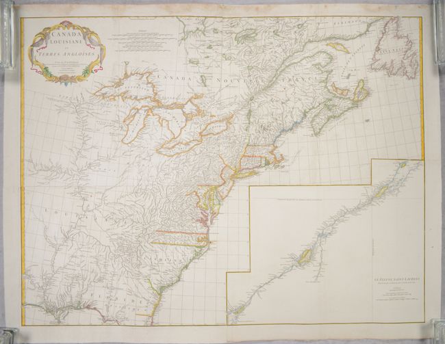
Auction 204, Lot 96
Subject: Colonial Eastern United States & Canada
Anville, Jean Baptiste Bourguignon d'
[On 4 Joined Sheets] Canada Louisiane et Terres Angloises, 1755
Size: 44.8 x 33.9 inches (113.8 x 86.1 cm)
Estimate: $1,400 - $1,700
D'Anville's Spectacular Map of Eastern Seaboard on 4 Joined Sheets
Sold for: $1,000
Closed on 6/18/2025

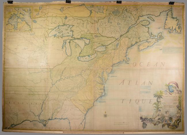
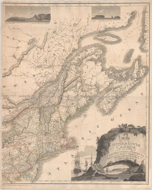
Auction 204, Lot 104
Subject: Northeastern United States & Canada
Bouchette, Joseph
[Eastern Sheet] Map of the Provinces of Upper & Lower Canada with the Adjacent Parts of the United States of America &c. Compiled from the Latest Surveys and Adjusted from the Most Recent and Approved Astronomical Observations, 1815
Size: 24.3 x 30 inches (61.7 x 76.2 cm)
Estimate: $2,400 - $3,000
Eastern Sheet of Bouchette's Rare Map Presenting Lower Canada and New England
Unsold
Closed on 6/18/2025

Auction 203, Lot 86
Subject: Colonial Eastern United States & Canada
Fer, Nicolas de
Carte de la Nouvelle France, ou se Voit le Cours des Grandes Rivieres de S. Laurens & de Mississipi Aujour d'hui S. Louis, aux Environs des-quelles se Trouvent les Etats, Pais, Nations, Peuples, &c. de la Floride, de la Louisiane, de la Virginie..., 1720
Size: 21.9 x 19.8 inches (55.6 x 50.3 cm)
Estimate: $2,750 - $3,500
Striking Map of French Colonial Possessions
Sold for: $2,200
Closed on 4/23/2025
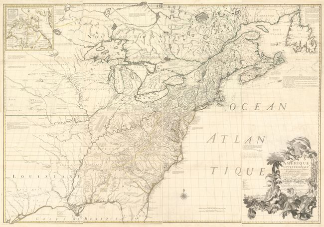
Auction 203, Lot 89
Subject: Colonial Eastern United States & Canada
Mitchell/Le Rouge
Amerique Septentrionale avec les Routes, Distances en Miles, Villages et Etablissements Francois et Anglois par le Docteur Mitchel, 1777
Size: 75 x 52.4 inches (190.5 x 133.1 cm)
Estimate: $9,500 - $12,000
Third French Edition of Mitchell's Monumental Map
Sold for: $5,000
Closed on 4/23/2025
Auction 203, Lot 95
Subject: Colonial Northeastern United States & Canada
Rhode, Johann Cristoph
Theatrum Belli in America Septentrionali II. Foiliis Comprehensum..., 1755
Size: 31.5 x 22 inches (80 x 55.9 cm)
Estimate: $8,000 - $9,500
Scarce German Map Illustrating the French & Indian War
Sold for: $5,000
Closed on 4/23/2025
Auction 203, Lot 103
Subject: Northwestern United States & Canada
Wilkes, Charles
Map of the Oregon Territory by the U.S. Ex. Ex., 1841
Size: 34.1 x 22.9 inches (86.6 x 58.2 cm)
Estimate: $1,400 - $1,700
One of the Most Detailed and Important 19th-Century Maps of the American Northwest
Sold for: $1,100
Closed on 4/23/2025
Auction 202, Lot 102
Subject: Colonial Eastern United States & Canada
Chatelain, Henry Abraham
Carte de la Nouvelle France, ou se voit les Cours des Grandes Rivieres de S. Laurens & de Mississipi Aujour d'hui S. Louis, aux Environs des quelles se Trouvent les Etats, Pais, Nations, Peuples &c. de la Floride, de la Louisiane, de la Virginie..., 1719
Size: 19 x 16.5 inches (48.3 x 41.9 cm)
Estimate: $3,000 - $3,750
One of the Most Informative 18th Century Maps of the French Possessions in North America
Sold for: $2,000
Closed on 2/12/2025
Auction 202, Lot 106
Subject: Northeastern United States & Canada
Bouchette, Joseph
[Eastern Sheet] Map of the Provinces of Upper & Lower Canada with the Adjacent Parts of the United States of America &c. Compiled from the Latest Surveys and Adjusted from the Most Recent and Approved Astronomical Observations, 1815
Size: 24.3 x 30 inches (61.7 x 76.2 cm)
Estimate: $2,750 - $3,500
Eastern Sheet of Bouchette's Rare Map Presenting Lower Canada and New England
Unsold
Closed on 2/12/2025
Auction 201, Lot 98
Subject: Montreal, Canada
Gastaldi/Ramusio
La Terra de Hochelaga Nella Nova Francia, 1556
Size: 15.1 x 10.9 inches (38.4 x 27.7 cm)
Estimate: $3,000 - $3,750
Rare First Edition of the First Published Plan of a Settlement in North America
Sold for: $4,750
Closed on 11/20/2024
Auction 201, Lot 105
Subject: Colonial Eastern United States & Canada
Fer, Nicolas de
Carte de la Nouvelle France, ou se Voit le Cours des Grandes Rivieres de S. Laurens & de Mississipi Aujour d'hui S. Louis, aux Environs des-quelles se Trouvent les Etats, Pais, Nations, Peuples, &c. de la Floride, de la Louisiane, de la Virginie..., 1720
Size: 21.9 x 19.8 inches (55.6 x 50.3 cm)
Estimate: $2,750 - $3,500
Striking Map of French Colonial Possessions
Unsold
Closed on 11/20/2024
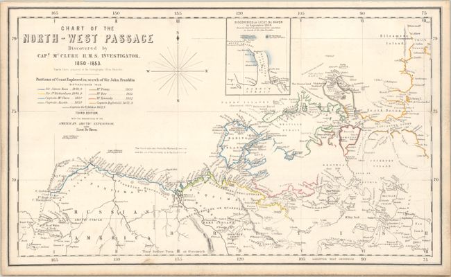
Auction 201, Lot 118
Subject: Canada & Alaska
Johnston, W. & A.K.
Chart of the North-West Passage Discovered by Capt. McClure H.M.S. Investigator, 1850-1853, 1855
Size: 20.5 x 12.2 inches (52.1 x 31 cm)
Estimate: $1,000 - $1,300
One of the First Maps to Depict the Northwest Passage and New Discoveries in the Arctic
Sold for: $2,200
Closed on 11/20/2024
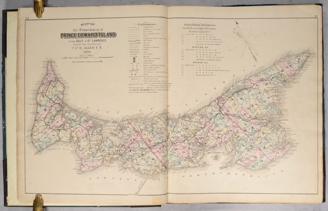
Auction 199, Lot 92
Subject: Prince Edward Island, Canada, Atlases
Illustrated Historical Atlas of the Province of Prince Edward Island..., 1880
Size: 14.6 x 17.8 inches (37.1 x 45.2 cm)
Estimate: $1,500 - $1,800
Highly Detailed Atlas of Prince Edward Island
Sold for: $750
Closed on 9/11/2024
Auction 199, Lot 101
Subject: Colonial Eastern United States & Canada
Senex, John
A New Map of the English Empire in America viz Virginia Maryland Carolina Pennsylvania New York New Iarsey New England Newfoundland New France &c., 1719
Size: 23.3 x 19.8 inches (59.2 x 50.3 cm)
Estimate: $2,400 - $3,000
Senex's Important Map of the American Colonies
Sold for: $1,800
Closed on 9/11/2024
Auction 199, Lot 105
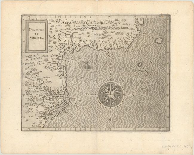
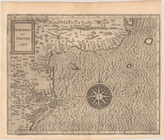
Subject: Colonial Northeastern United States & Canada
Wytfliet, Cornelis
Norumbega et Virginia, 1607
Size: 11.6 x 9.1 inches (29.5 x 23.1 cm)
Estimate: $2,750 - $3,500
Important, Early Map of the East Coast with Mythical City
Sold for: $2,000
Closed on 9/11/2024
Auction 198, Lot 90
Subject: Colonial Eastern United States & Canada
Homann, Johann Baptist
Amplissimae Regionis Mississipi seu Provinciae Ludovicianae a R.P. Ludovico Hennepin Francisc Miss in America Septentrionali Anno 1687..., 1720
Size: 23 x 19.4 inches (58.4 x 49.3 cm)
Estimate: $2,000 - $2,300
Striking Map of Colonial America with Bison Vignette
Sold for: $1,500
Closed on 6/19/2024

Auction 198, Lot 95
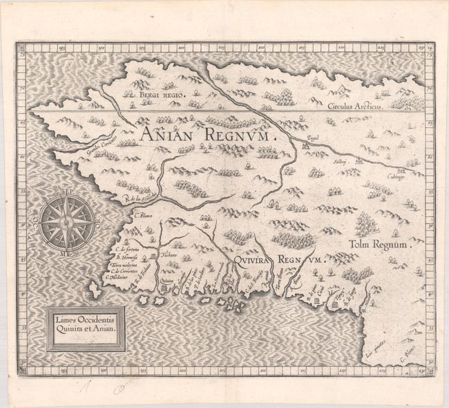
Subject: Alaska & Western Canada
Wytfliet, Cornelis
Limes Occidentis Quivira et Anian, 1607
Size: 11.6 x 9.3 inches (29.5 x 23.6 cm)
Estimate: $1,800 - $2,200
Early and Imaginary Map of Alaska and the Northwest Passage
Sold for: $1,000
Closed on 6/19/2024
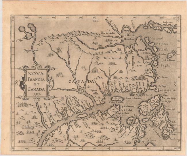
Auction 197, Lot 86
Subject: Eastern Canada
Wytfliet, Cornelis
Nova Francia et Canada, 1597
Size: 11.6 x 9.3 inches (29.5 x 23.6 cm)
Estimate: $2,000 - $2,300
First State of Wytfliet's Landmark Map of Eastern Canada
Sold for: $3,500
Closed on 4/24/2024
Auction 197, Lot 98
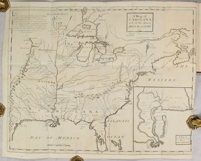
Subject: Colonial Eastern United States & Canada
Coxe, Daniel
[Map in Book] A Map of Carolana and of the River Meschacebe &c. [in] A Description of the English Province of Carolana. By the Spaniards Call'd Florida, and by the French, la Louisiane, 1741
Size: 21.5 x 16.8 inches (54.6 x 42.7 cm)
Estimate: $8,000 - $9,500
First English Depiction of the Mississippi Valley
Sold for: $7,500
Closed on 4/24/2024
Auction 197, Lot 100
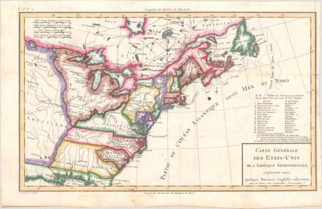
Subject: Eastern United States & Canada, Franklin
Crevecoeur, Michel Guillaume De
Carte Generale des Etats-Unis de l'Amerique Septentrionale, Renfermant Aussi Quelques Provinces Angloises Adjacentes, pour les Lettres d'un Cultivateur Ameriquain, 1787
Size: 16.9 x 10.2 inches (42.9 x 25.9 cm)
Estimate: $600 - $750
One of the Earliest Maps to Name Franklinia
Sold for: $450
Closed on 4/24/2024
Auction 196, Lot 123
Subject: Colonial Northeastern United States & Canada
Wytfliet, Cornelis
Norumbega et Virginia, 1597
Size: 11.6 x 9.1 inches (29.5 x 23.1 cm)
Estimate: $2,750 - $3,500
Important, Early Map of the East Coast with Mythical City
Sold for: $3,750
Closed on 2/7/2024
Auction 196, Lot 127
Subject: Alaska & Western Canada
Wytfliet, Cornelis
Limes Occidentis Quivira et Anian, 1607
Size: 11.6 x 9.3 inches (29.5 x 23.6 cm)
Estimate: $2,000 - $2,300
Early and Imaginary Map of Alaska and the Northwest Passage
Unsold
Closed on 2/7/2024
Auction 195, Lot 134
Subject: Eastern United States & Canada
Ruscelli, Girolamo
Tierra Nueva, 1574
Size: 9.7 x 7.1 inches (24.6 x 18 cm)
Estimate: $1,200 - $1,500
Ruscelli's Map of the East Coast
Sold for: $850
Closed on 11/15/2023
Auction 195, Lot 137
Subject: Colonial Eastern United States & Canada
Mitchell/Le Rouge
[On 8 Sheets] Amerique Septentrionale avec les Routes, Distances en Miles, Villages et Etablissements Francois et Anglois..., 1756
Size: 19 x 26.8 inches (48.3 x 68.1 cm)
Estimate: $10,000 - $13,000
French Edition of Mitchell's Monumental Map
Sold for: $7,500
Closed on 11/15/2023
381 lots
Page 1 of 8