Subject: Montreal, Canada
Period: 1556 (published)
Publication: Terzo Volume delle Navigationi et Viaggi
Color: Black & White
Size:
14.5 x 10.6 inches
36.8 x 26.9 cm
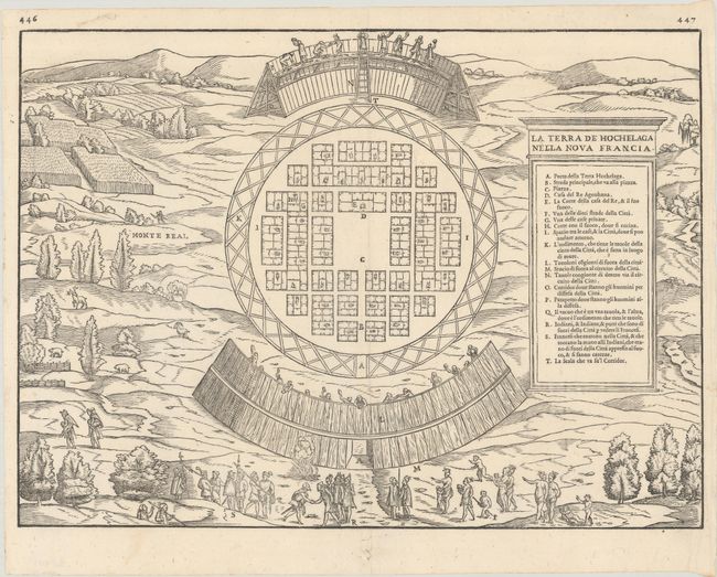
This is the first published plan of a settlement in North America, and the first plan of the site of Montreal showing the Indian settlement, Hochelaga, visited by Jacques Cartier in 1535-36. Cartier was a French explorer and is credited with being the first European to map the Gulf of St. Lawrence and the St. Lawrence River. During Cartier's first trip to the new world in 1534, he explored Newfoundland and the Gulf of St. Lawrence in an attempt to discover a western passage to Asia. On his second voyage in 1535-36, Cartier sailed up the St. Lawrence River reaching the Iroquoian capital of Stadacona, which later became Quebec City, and then continued further upriver to Hochelaga, arriving on October 2, 1535. Cartier described the Indian village as being near Mont Real, a great and fertile mountain surrounded by many types of trees, including oaks, elms, walnut, cedars, firs, and willows. The name Monte Real appears to the left of the village, and is the first appearance of the name on a map.
The village is laid out in a circular form and protected by wooden barriers. The house-like structures in the village are arranged in a geometrical pattern, with a fire depicted in the middle of each structure. Cartier and his crew are pictured in the foreground being greeted by their Indian hosts. Various types of trees are depicted, as well as several animals and what appears to be a corn field at top left.
This map was first published in Giovanni Battista Ramusio's Navigationi et Viaggi in 1556. The first woodblock was destroyed by fire in 1557, and this plan is the second edition from a new block with a "weeping willow" type tree in the upper right and the page numbers 446 and 447 above the neatline.
References: Goss #7; Kershaw #17a; Mickwitz & Miekkavaara #641 Vol. III #8; Schwartz & Ehrenberg, plt. 28; Shirley (BL Atlases) G.RAMU-2a #9.
Condition: A
A nice impression on a bright sheet with a small crown watermark, an archivally repaired tear in the bottom blank margin, and faint marginal soiling.