Showing Featured Lots(remove filter)
Filtered by Category:United States(Show All Categories)
Catalog Archive
2322 lots
Page 1 of 47
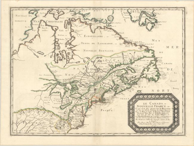
Auction 208, Lot 117
Subject: Colonial Eastern United States & Canada
Sanson/Mariette
Le Canada, ou Nouvelle France, &c. ce qui est le Plus Advance Vers le Septentrion est Tire de Diverses Relations des Anglois, Danois, &c..., 1656
Size: 21.4 x 15.9 inches (54.4 x 40.4 cm)
Estimate: $4,000 - $4,750
Keystone Map for Great Lakes Collections
Unsold
Closed on 4/22/2026
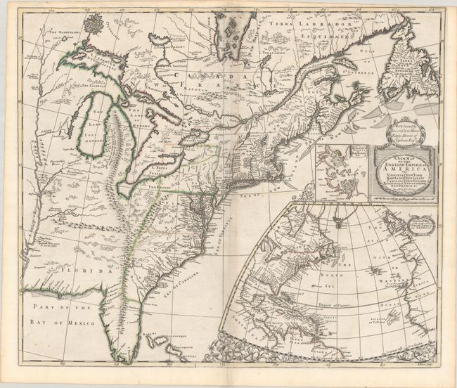
Auction 208, Lot 119
Subject: Colonial Eastern United States & Canada
Senex, John
A New Map of the English Empire in America viz Virginia Maryland Carolina Pennsylvania New York New Iarsey New England Newfoundland New France &c., 1719
Size: 22.9 x 19.6 inches (58.2 x 49.8 cm)
Estimate: $2,000 - $2,300
Senex's Important Map of the American Colonies
Sold for: $1,500
Closed on 4/22/2026
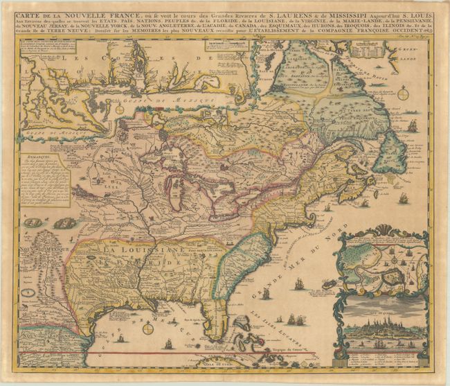
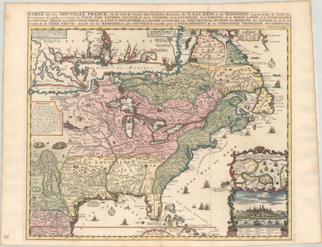
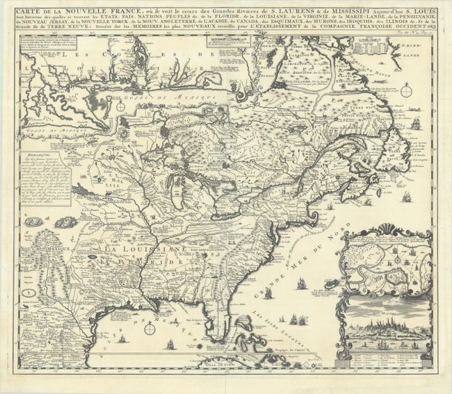
Auction 208, Lot 120
Subject: Colonial Eastern United States & Canada
Chatelain, Henry Abraham
Carte de la Nouvelle France, ou se voit les Cours des Grandes Rivieres de S. Laurens & de Mississipi Aujour d'hui S. Louis, aux Environs des-quelles se Trouvent les Etats, Pais, Nations, Peuples &c. de la Floride, de la Louisiane, de la Virginie..., 1719
Size: 19.4 x 16.6 inches (49.3 x 42.2 cm)
Estimate: $2,400 - $3,000
One of the Most Informative 18th-Century Maps of the French Possessions in North America
Unsold
Closed on 4/22/2026
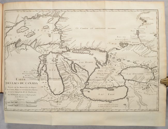
Auction 208, Lot 121
Subject: Colonial Eastern United States & Canada
Charlevoix, P. F. Xavier de
Journal d'un Voyage Fait par Ordre du Roi dans l'Amerique Septentrionale ... Tome Troisieme, 1744
Size: 8.5 x 10.6 inches (21.6 x 26.9 cm)
Estimate: $2,000 - $2,300
Volume III of Charlevoix's Travels Through Colonial North America, with Bellin's Important Map of the Great Lakes
Sold for: $1,500
Closed on 4/22/2026

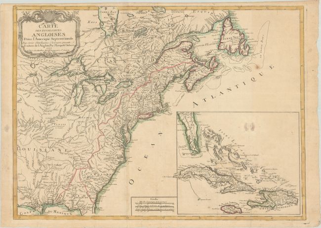
Auction 208, Lot 123
Subject: Colonial Eastern United States & Canada
Imbert, J. Leopold
Carte des Possessions Angloises dans l'Amerique Septentrionale pour Servir d'Intelligence a la Guerre Presente Traduite de l'Anglois, 1777
Size: 29 x 21.3 inches (73.7 x 54.1 cm)
Estimate: $1,500 - $1,800
First Edition of Important Revolutionary War Map
Unsold
Closed on 4/22/2026
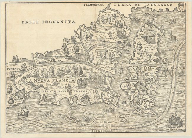
Auction 208, Lot 127
Subject: Colonial Northeastern United States & Canada
Gastaldi/Ramusio
La Nuova Francia, 1565
Size: 14.6 x 10.6 inches (37.1 x 26.9 cm)
Estimate: $4,500 - $5,500
The First Printed Map to Focus on New England and New France
Sold for: $4,250
Closed on 4/22/2026
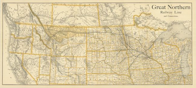
Auction 208, Lot 137
Subject: Western United States & Canada, Railroads
Railroad Companies, (Various)
Great Northern Railway Line and Connections, 1890
Size: 35.6 x 15.6 inches (90.4 x 39.6 cm)
Estimate: $250 - $325
Scarce Railroad Map with Bizarre Depictions of Montana and Wyoming. Colorado Is Off the Map!
Sold for: $180
Closed on 4/22/2026
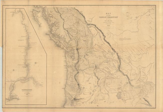
Auction 208, Lot 138
Subject: Northwestern United States & Canada
Wilkes, Charles
Map of the Oregon Territory by the U.S. Ex. Ex., 1841
Size: 34.3 x 23 inches (87.1 x 58.4 cm)
Estimate: $1,400 - $1,700
One of the Most Detailed and Important 19th-Century Maps of the American Northwest
Sold for: $1,000
Closed on 4/22/2026
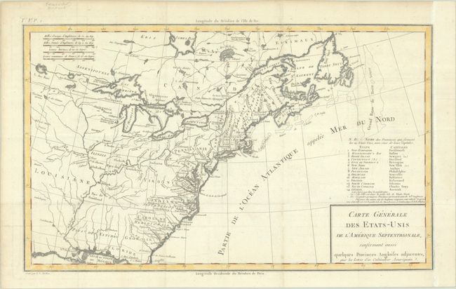
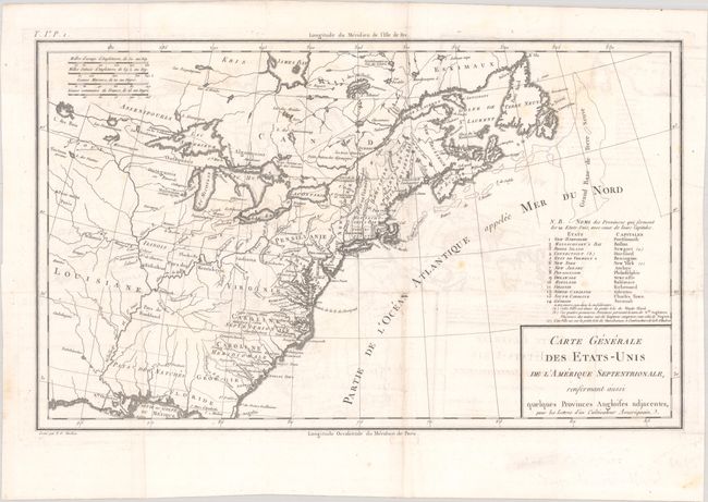
Auction 208, Lot 163
Subject: Eastern United States
Crevecoeur, Michel Guillaume De
Carte Generale des Etats-Unis de l'Amerique Septentrionale, Renfermant Aussi Quelques Provinces Angloises Adjacentes, pour les Lettres d'un Cultivateur Ameriquain, 1787
Size: 16.8 x 10.2 inches (42.7 x 25.9 cm)
Estimate: $750 - $900
One of the Earliest Maps to Name Franklinia
Sold for: $550
Closed on 4/22/2026
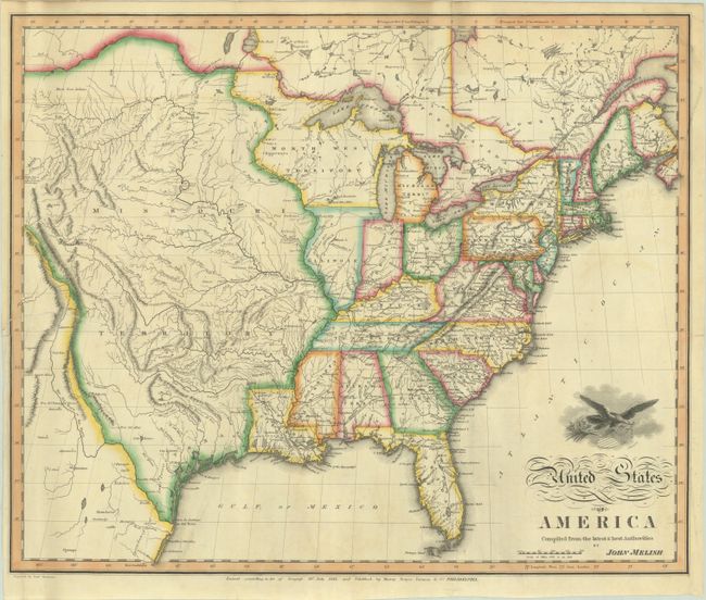
Auction 208, Lot 164
Subject: Eastern United States
Melish, John
United States of America Compiled from the Latest & Best Authorities, 1818
Size: 19.6 x 16.3 inches (49.8 x 41.4 cm)
Estimate: $2,000 - $2,750
Early & Separately Issued Version of Melish's Important Map
Sold for: $1,000
Closed on 4/22/2026
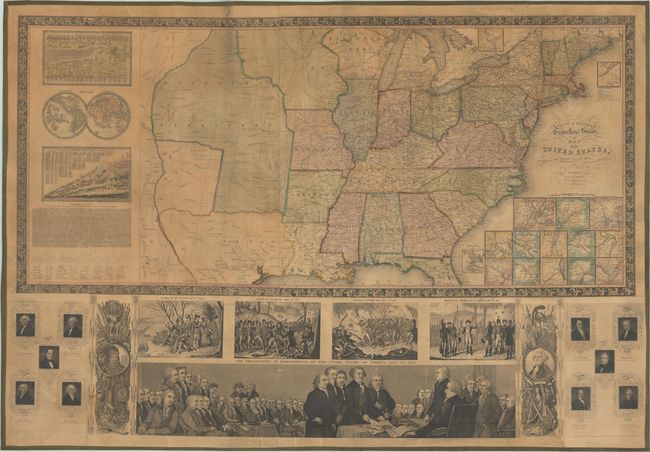
Auction 208, Lot 168
Subject: Eastern United States, Texas
Phelps & Ensign
Phelps & Ensign's Travellers' Guide, and Map of the United States, Containing the Roads, Distances, Steam Boat and Canal Routes &c., 1844
Size: 38.6 x 25.6 inches (98 x 65 cm)
Estimate: $1,600 - $1,900
Attractive Wall Map Featuring the Republic of Texas
Unsold
Closed on 4/22/2026

Auction 208, Lot 172
Subject: Colonial New England & Mid-Atlantic United States
Blaeu, (Family)
Nova Belgica et Anglia Nova, 1642
Size: 20 x 15.3 inches (50.8 x 38.9 cm)
Estimate: $1,800 - $2,100
Important Map of Colonial New England and the Mid-Atlantic - Full Contemporary Color
Unsold
Closed on 4/22/2026
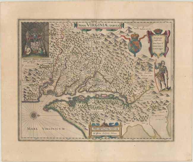
Auction 208, Lot 177
Subject: Colonial Mid-Atlantic United States
Hondius/Blaeu
Nova Virginiae Tabula, 1635
Size: 18.8 x 14.8 inches (47.8 x 37.6 cm)
Estimate: $1,900 - $2,200
One of the Most Important 17th Century Maps of the Chesapeake Bay in Full Contemporary Color
Sold for: $1,400
Closed on 4/22/2026
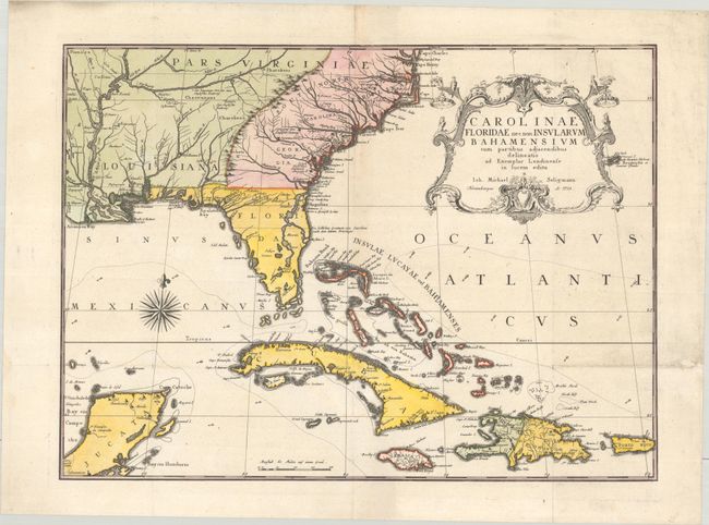
Auction 208, Lot 181
Subject: Colonial Southeastern United States, Bahamas & Greater Antilles
Seligmann, Johann Michael
Carolinae Floridae nec non Insularum Bahamensium cum Partibus Adjacendibus Delineatio ad Exemplar Londinense in Lucem Edita, 1755
Size: 23.2 x 16.9 inches (58.9 x 42.9 cm)
Estimate: $3,750 - $4,500
German Edition of Catesby's Scarce and Important Map of the Southeastern United States
Sold for: $1,900
Closed on 4/22/2026
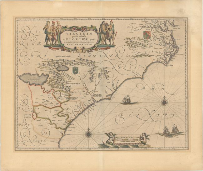
Auction 208, Lot 182
Subject: Colonial Southeastern United States
Blaeu, Willem
Virginiae Partis Australis, et Floridae Partis Orientalis, Interjacentiumq Regionum Nova Descriptio, 1643
Size: 19.9 x 15.2 inches (50.5 x 38.6 cm)
Estimate: $1,000 - $1,300
Blaeu's Decorative Map of the Southeast in Full Contemporary Color
Sold for: $750
Closed on 4/22/2026
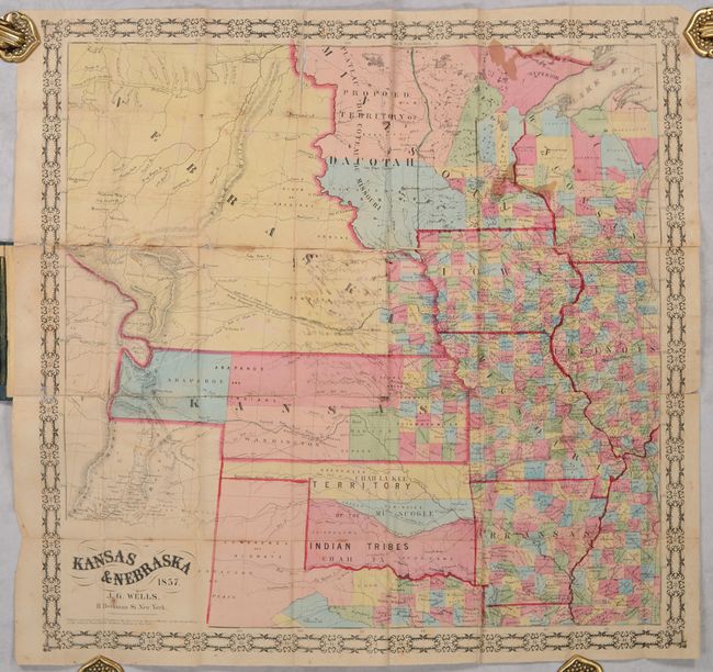
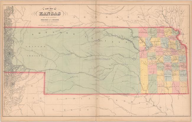
Auction 208, Lot 194
Subject: Central United States
Morse & Gaston
Kansas & Nebraska, 1857
Size: 20.6 x 20.6 inches (52.3 x 52.3 cm)
Estimate: $2,000 - $2,500
Early and Rare Map of Kansas & Nebraska Territories
Sold for: $2,000
Closed on 4/22/2026

Auction 208, Lot 214
Subject: Silicon Valley, California
Silicon Valley, 1984
Size: 23.3 x 34.8 inches (59.2 x 88.4 cm)
Estimate: $600 - $750
Rare Edition of View of the World from Silicon Valley
Unsold
Closed on 4/22/2026
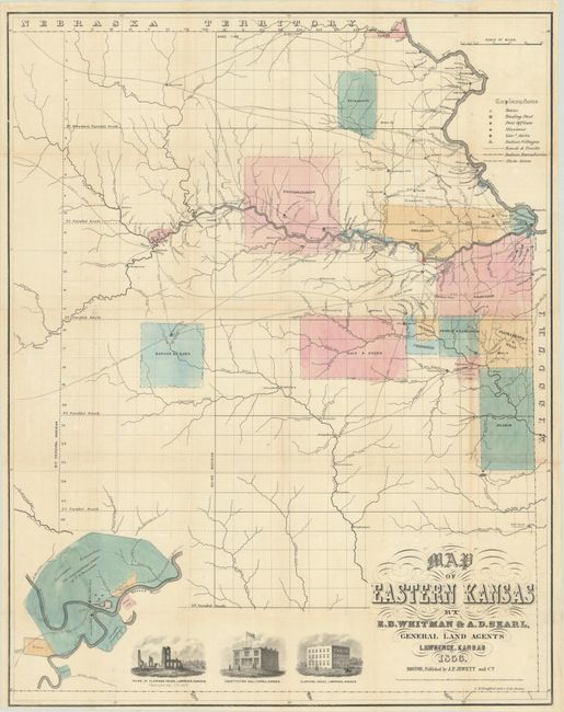
Auction 208, Lot 248
Subject: Eastern Kansas
Jewett & Co., J. P.
Map of Eastern Kansas, 1856
Size: 21.1 x 26.8 inches (53.6 x 68.1 cm)
Estimate: $1,100 - $1,400
Early Map of "Bleeding Kansas"
Sold for: $600
Closed on 4/22/2026
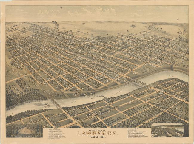
Auction 208, Lot 249
Subject: Lawrence, Kansas
Bird's Eye View of Lawrence. Kansas, 1880, 1880
Size: 30.6 x 22.1 inches (77.7 x 56.1 cm)
Estimate: $1,600 - $1,900
Striking Bird's-Eye View of Lawrence
Unsold
Closed on 4/22/2026
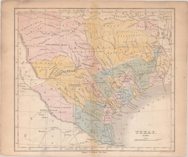
Auction 208, Lot 297
Subject: Texas
Kemble, W.
Texas. In 1836, 1848
Size: 9.4 x 8.4 inches (23.9 x 21.3 cm)
Estimate: $1,200 - $1,500
Republic of Texas with Land Grants
Sold for: $900
Closed on 4/22/2026
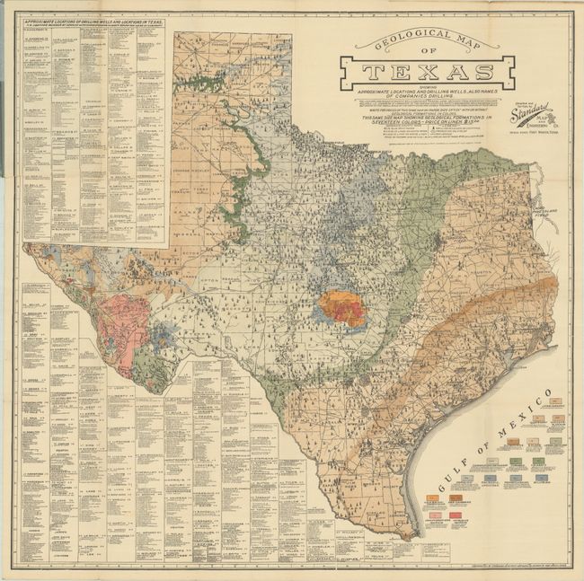
Auction 208, Lot 298
Subject: Texas, Oil
Geological Map of Texas Showing Approximate Locations and Drilling Wells, Also Names of Companies Drilling, 1920
Size: 25.1 x 25.1 inches (63.8 x 63.8 cm)
Estimate: $3,000 - $3,750
Rare Texas Oilfield Map
Sold for: $3,750
Closed on 4/22/2026
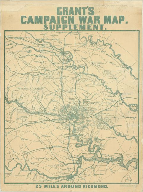
Auction 208, Lot 304
Subject: Richmond, Virginia
Bufford, J. H.
Grant's Campaign War Map. Supplement. 25 Miles Around Richmond, 1864
Size: 14.4 x 16.4 inches (36.6 x 41.7 cm)
Estimate: $750 - $900
Rare Civil War Broadside Showing Richmond and Vicinity in May 1864
Unsold
Closed on 4/22/2026
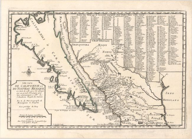
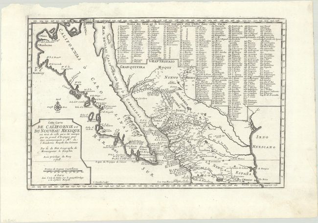
Auction 208, Lot 309
Subject: Southwestern United States & Mexico, California
Fer, Nicolas de
Cette Carte de Californie et du Nouveau Mexique, est Tiree de Celle qui a ete Envoyee par un Grand d'Espagne pour Etre Communiquee a Mrs. de l'Academie Royale des Sciences, 1700
Size: 13.6 x 9.1 inches (34.5 x 23.1 cm)
Estimate: $1,100 - $1,400
De Fer's Important Map of the Island of California - First State
Unsold
Closed on 4/22/2026
Auction 207, Lot 58
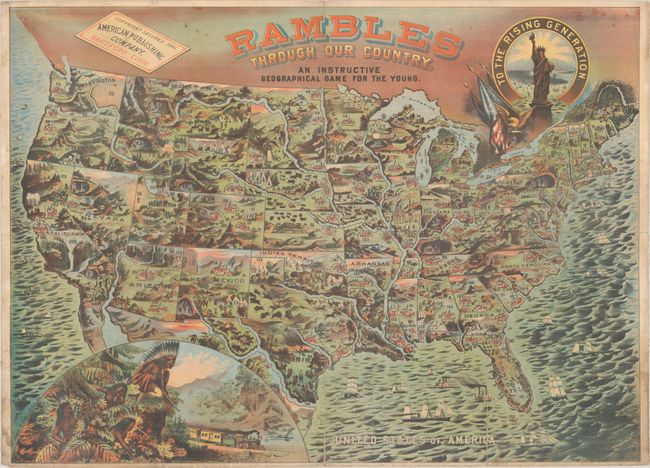
Subject: Cartographic Miscellany, Game, United States
American Publishing Company
Rambles Through Our Country. An Instructive Geographical Game for the Young, 1881
Size: 33.3 x 24.1 inches (84.6 x 61.2 cm)
Estimate: $2,000 - $2,300
Gorgeous Map That Doubles as a Game Board - First Edition
Sold for: $1,000
Closed on 2/11/2026
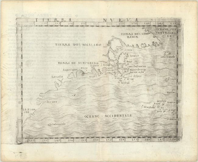
Auction 207, Lot 114
Subject: Eastern United States & Canada
Gastaldi, Giacomo
Tierra Nueva, 1548
Size: 6.8 x 5 inches (17.3 x 12.7 cm)
Estimate: $3,500 - $4,250
The First Published Map Devoted to the East Coast of North America
Sold for: $2,500
Closed on 2/11/2026
Auction 207, Lot 116
Subject: Colonial Eastern United States & Canada
Chatelain, Henry Abraham
Carte de la Nouvelle France, ou se Voit le Cours des Grandes Rivieres de S. Laurens & de Mississipi Aujour d'hui S. Louis, aux Environs des-quelles se Trouvent les Etats, Pais, Nations, Peuples &c. de la Floride, de la Louisiane, de la Virginie..., 1719
Size: 19.4 x 16.6 inches (49.3 x 42.2 cm)
Estimate: $2,300 - $2,750
One of the Most Informative 18th Century Maps of the French Possessions in North America
Sold for: $1,200
Closed on 2/11/2026
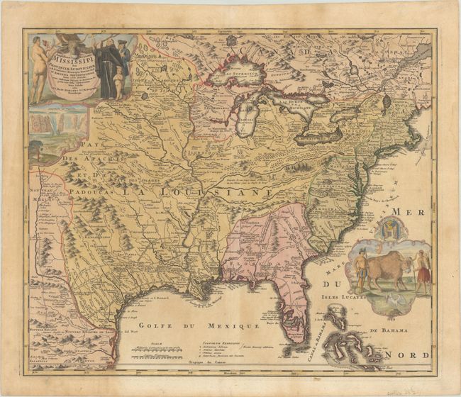
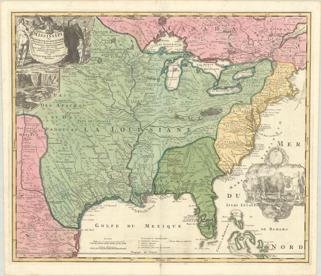
Auction 207, Lot 117
Subject: Colonial Eastern United States & Canada
Homann, Johann Baptist
Amplissimae Regionis Mississipi seu Provinciae Ludovicianae a R.P. Ludovico Hennepin Francisc Miss in America Septentrionali Anno 1687..., 1720
Size: 22.9 x 19.3 inches (58.2 x 49 cm)
Estimate: $2,000 - $2,300
Striking Map of Colonial America with Bison Vignette
Sold for: $1,100
Closed on 2/11/2026
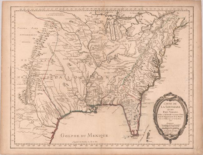
Auction 207, Lot 151
Subject: Colonial Eastern United States
Bellin, Jacques Nicolas
Carte de la Louisiane et des Pays Voisins Dediee a M. Rouille Secretaire d'Etat, ayant le Departement de la Marine, 1755
Size: 24.3 x 18.9 inches (61.7 x 48 cm)
Estimate: $1,600 - $1,900
Bellin's Scarce French and Indian War-Era Map of the Colonial United States
Sold for: $1,200
Closed on 2/11/2026
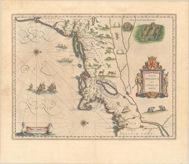
Auction 207, Lot 161
Subject: Colonial New England & Mid-Atlantic United States
Blaeu, (Family)
Nova Belgica et Anglia Nova, 1640
Size: 19.9 x 15.3 inches (50.5 x 38.9 cm)
Estimate: $1,800 - $2,100
Important Map of Colonial New England and the Mid-Atlantic - Full Contemporary Color
Sold for: $1,900
Closed on 2/11/2026
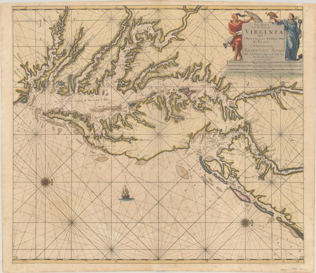
Auction 207, Lot 169
Subject: Colonial Mid-Atlantic United States, Chesapeake & Delaware Bays
Keulen, Johannes van
Pas Kaart van de Zee Kusten van Virginia Tusschen C Henry en t Hooge Land van Renselaars Hoek, 1695
Size: 22.6 x 20 inches (57.4 x 50.8 cm)
Estimate: $4,750 - $6,000
Price reduced by $250! One of the Earliest Maps to Show Philadelphia
Unsold
Closed on 2/11/2026
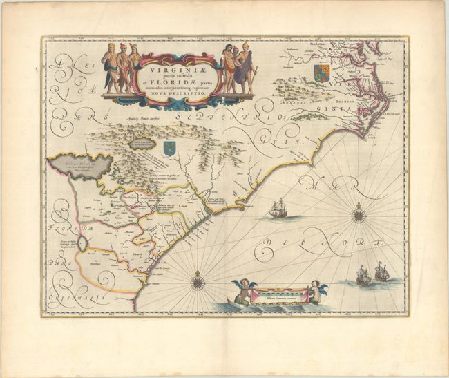
Auction 207, Lot 174
Subject: Colonial Southeastern United States
Blaeu, Willem
Virginiae Partis Australis, et Floridae Partis Orientalis, Interjacentiumq Regionum Nova Descriptio, 1640
Size: 19.9 x 15.2 inches (50.5 x 38.6 cm)
Estimate: $900 - $1,100
Blaeu's Decorative Map of the Southeast in Full Contemporary Color
Sold for: $600
Closed on 2/11/2026
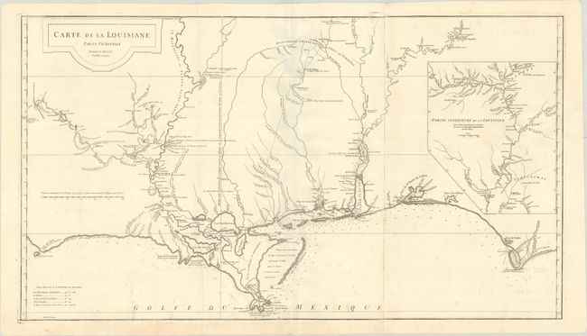
Auction 207, Lot 185
Subject: Colonial Gulf Coast
Anville, Jean Baptiste Bourguignon d'
Carte de la Louisiane, 1752
Size: 36.4 x 20.4 inches (92.5 x 51.8 cm)
Estimate: $1,500 - $1,800
An Early, Detailed Depiction of the Gulf Coast
Sold for: $1,100
Closed on 2/11/2026
Auction 207, Lot 192
Subject: Colorado & Kansas
Desilver, Charles
A New Map of Kansas by W.H. Holmes, 1859
Size: 27 x 16.1 inches (68.6 x 40.9 cm)
Estimate: $2,000 - $2,300
One of the Earliest Maps to Name Denver
Sold for: $2,200
Closed on 2/11/2026
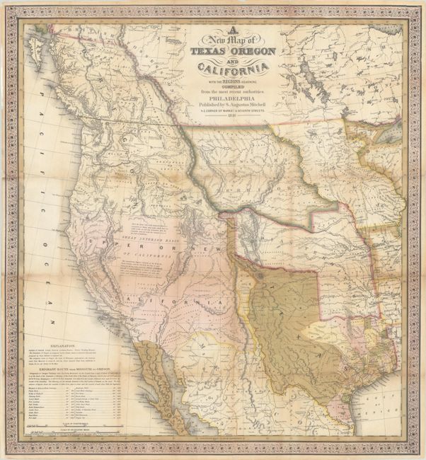
Auction 207, Lot 197
Subject: Western United States, Texas
Mitchell, Samuel Augustus
A New Map of Texas Oregon and California with the Regions Adjoining. Compiled from the Most Recent Authorities, 1846
Size: 20.6 x 22.3 inches (52.3 x 56.6 cm)
Estimate: $9,500 - $12,000
One of the Most Influential Maps of Westward Expansion
Sold for: $7,000
Closed on 2/11/2026
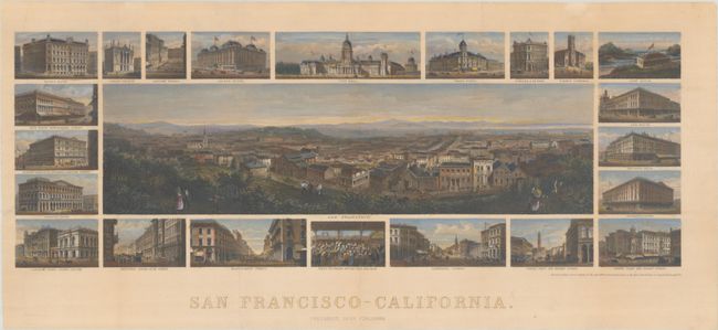
Auction 207, Lot 220
Subject: San Francisco, California
San Francisco - California, 1874
Size: 24.4 x 8.7 inches (62 x 22.1 cm)
Estimate: $2,200 - $2,500
A Fine, Early Rendering of San Francisco
Sold for: $1,600
Closed on 2/11/2026
Auction 207, Lot 233
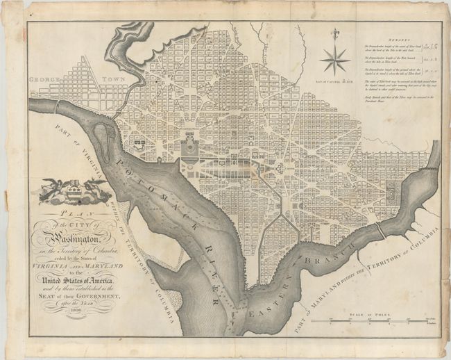
Subject: Washington, D.C.
Russell, John C.
Plan of the City of Washington, in the Territory of Columbia, Ceded by the States of Virginia and Maryland to the United States of America, and by Them Established as the Seat of Their Government, After the Year 1800, 1795
Size: 20.8 x 15.9 inches (52.8 x 40.4 cm)
Estimate: $1,600 - $1,900
Rare & Early, Large-Format Map of Washington D.C.
Sold for: $2,500
Closed on 2/11/2026
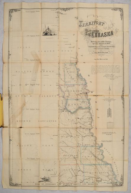
Auction 207, Lot 285
Subject: Nebraska
The Territory of Nebraska Embracing the Public Surveys Up to the Summer of 1857..., 1857
Size: 22.8 x 34.6 inches (57.9 x 87.9 cm)
Estimate: $4,000 - $5,000
Rare and Early Map of Nebraska Territory
Sold for: $6,000
Closed on 2/11/2026
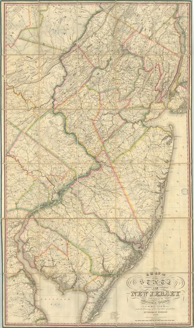
Auction 207, Lot 288
Subject: New Jersey
Gordon, Thomas F.
A Map of the State of New Jersey with Part of the Adjoining States Compiled Under the Patronage of the Legislature of Said State, 1828
Size: 32.6 x 56.7 inches (82.8 x 144 cm)
Estimate: $6,000 - $7,500
The First Official Map of New Jersey
Unsold
Closed on 2/11/2026
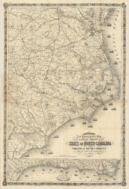
Auction 207, Lot 295
Subject: North Carolina, Civil War
Colton, Joseph Hutchins
Colton's New Topographical Map of the Eastern Portion of the State of North Carolina with Part of Virginia & South Carolina from the Latest and Best Authorities, 1863
Size: 27 x 39.9 inches (68.6 x 101.3 cm)
Estimate: $2,000 - $2,300
Scare Civil War Map of Eastern North Carolina
Sold for: $1,500
Closed on 2/11/2026
Auction 207, Lot 323
Subject: Southwestern United States & Mexico, California
Fer, Nicolas de
Cette Carte de Californie et du Nouveau Mexique, est Tiree de Celle qui a ete Envoyee par un Grand d'Espagne pour Etre Communiquee a Mrs. de l'Academie Royale des Sciences, 1705
Size: 13.4 x 8.9 inches (34 x 22.6 cm)
Estimate: $1,100 - $1,400
De Fer's Important Map of the Island of California
Sold for: $800
Closed on 2/11/2026
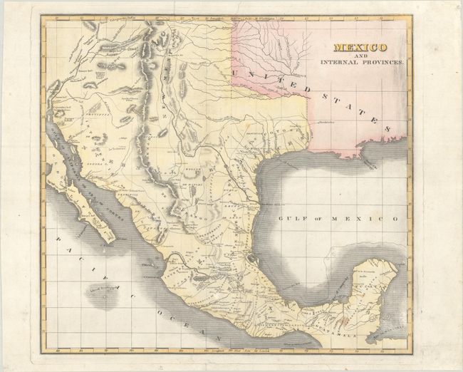
Auction 207, Lot 326
Subject: Southwestern United States & Mexico, Texas
Mexico and Internal Provinces, 1820
Size: 14.4 x 13.1 inches (36.6 x 33.3 cm)
Estimate: $700 - $850
Rare Map Featuring "Galverton", the "Brassos" River, and Southerly Flowing Rivers
Sold for: $1,200
Closed on 2/11/2026

Auction 206, Lot 108
Subject: Colonial Eastern United States & Canada
Sanson/Mariette
Le Canada, ou Nouvelle France, &c. ce qui est le Plus Advance Vers le Septentrion est Tire de Diverses Relations des Anglois, Danois, &c..., 1656
Size: 21.4 x 15.9 inches (54.4 x 40.4 cm)
Estimate: $4,000 - $4,750
Keystone Map for Great Lakes Collections
Unsold
Closed on 11/12/2025
Auction 206, Lot 109
Subject: Colonial Eastern United States & Canada
Chatelain, Henry Abraham
Carte de la Nouvelle France, ou se Voit le Cours des Grandes Rivieres de S. Laurens & de Mississipi Aujour d'hui S. Louis, aux Environs des-quelles se Trouvent les Etats, Pais, Nations, Peuples, &c. de la Floride, de la Louisiane, de la Virginie..., 1719
Size: 19.3 x 16.7 inches (49 x 42.4 cm)
Estimate: $2,000 - $2,300
One of the Most Informative 18th Century Maps of the French Possessions in North America
Unsold
Closed on 11/12/2025

Auction 206, Lot 110
Subject: Colonial Eastern United States & Canada
Senex, John
A New Map of the English Empire in America viz Virginia Maryland Carolina Pennsylvania New York New Iarsey New England Newfoundland New France &c., 1719
Size: 22.9 x 19.6 inches (58.2 x 49.8 cm)
Estimate: $2,400 - $3,000
Senex's Important Map of the American Colonies
Unsold
Closed on 11/12/2025
Auction 206, Lot 111
Subject: Colonial Eastern United States & Canada
Homann, Johann Baptist
Amplissimae Regionis Mississipi seu Provinciae Ludovicianae a R.P. Ludovico Hennepin Francisc Miss. in America Septentrionali Anno 1687..., 1720
Size: 22.8 x 19.2 inches (57.9 x 48.8 cm)
Estimate: $2,200 - $2,500
Striking Map of Colonial America with Bison Vignette
Sold for: $2,500
Closed on 11/12/2025
Auction 206, Lot 115
Subject: Colonial Eastern United States & Canada
Imbert, J. Leopold
Carte des Possessions Angloises dans l'Amerique Septentrionale pour Servir d'Intelligence a la Guerre Presente Traduite de l'Anglois, 1777
Size: 29 x 21.3 inches (73.7 x 54.1 cm)
Estimate: $1,800 - $2,200
First Edition of Important Revolutionary War Map
Unsold
Closed on 11/12/2025
Auction 206, Lot 116
Subject: Eastern United States & Canada, Franklin
Crevecoeur, Michel Guillaume De
Carte Generale des Etats-Unis de l'Amerique Septentrionale, Renfermant Aussi Quelques Provinces Angloises Adjacentes, pour les Lettres d'un Cultivateur Ameriquain, 1787
Size: 16.9 x 10.3 inches (42.9 x 26.2 cm)
Estimate: $750 - $900
One of the Earliest Maps to Name Franklinia
Sold for: $475
Closed on 11/12/2025
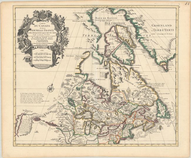
Auction 206, Lot 121
Subject: Colonial Northeastern United States & Canada
Delisle/Covens & Mortier
Carte du Canada ou de la Nouvelle France et des Decouvertes qui y ont ete Faites Dressee sur Plusieurs Observations et sur un Grand Nombre de Relations Imprimees ou Manuscrites, 1730
Size: 22.4 x 19.3 inches (56.9 x 49 cm)
Estimate: $1,200 - $1,500
One of the Most Influential Maps of Canada, Great Lakes & Upper Midwest
Sold for: $600
Closed on 11/12/2025
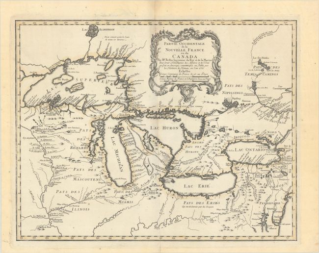
Auction 206, Lot 126
Subject: Colonial Great Lakes
Bellin/Homann Heirs
Partie Occidentale de la Nouvelle France ou du Canada, 1755
Size: 21.3 x 16.8 inches (54.1 x 42.7 cm)
Estimate: $1,500 - $1,800
Influential Map of the Great Lakes
Sold for: $1,000
Closed on 11/12/2025
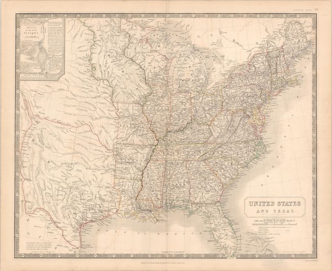
Auction 206, Lot 144
Subject: Eastern United States, Texas
Johnston, W. & A.K.
United States and Texas, 1842
Size: 24.3 x 19.8 inches (61.7 x 50.3 cm)
Estimate: $1,200 - $1,500
Scottish Atlas Map Featuring the Independent Republic of Texas
Sold for: $950
Closed on 11/12/2025
2322 lots
Page 1 of 47